General Observations
Severe weather was the story of the past week across the state. It has been a very weak severe weather season, but that all changed once we entered June. Daily tracking of severe weather reports from the Storm Prediction Center (SPC) indicates that Nebraska experienced severe weather every day from June 2nd, through the 7th, which is the end of this analysis period.
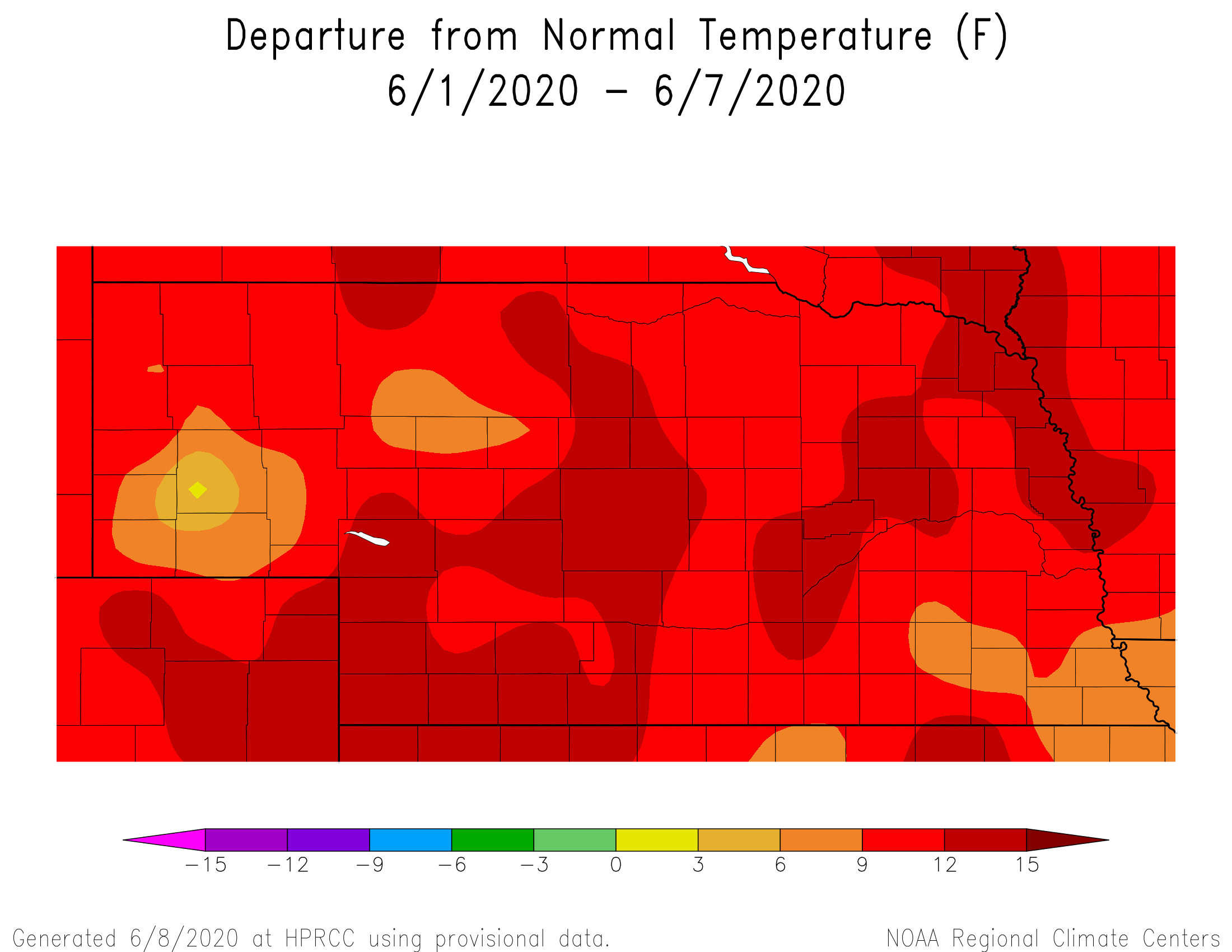
The leading cause of this severe weather outbreak can be summed up by energy moving in a northwest flow aloft during the first half of the period, switching to a large upper air trough across the western U.S. during the second half of the period. This led to very warm conditions during the period, with average temperatures ranging from6 to 12 F above normal (insert fig1-2004.png).. With the heat and energy moving through the region on a daily basis, severe weather was inevitable.
SPC indicated a preliminary total of 39 hail and 98 wind reports from June 2-7. No tornadoes were reported, continuing the trend of low tornadic activity this season across the state. So far, 4 tornadoes have been reported none more than a brief touchdown. The most significant severe weather outbreak occurred on June 6th when 7 hail and 46 wind events were reported. Peak wind gusts in the range of 60-80 mph were reported across the Panhandle and north central Nebraska.
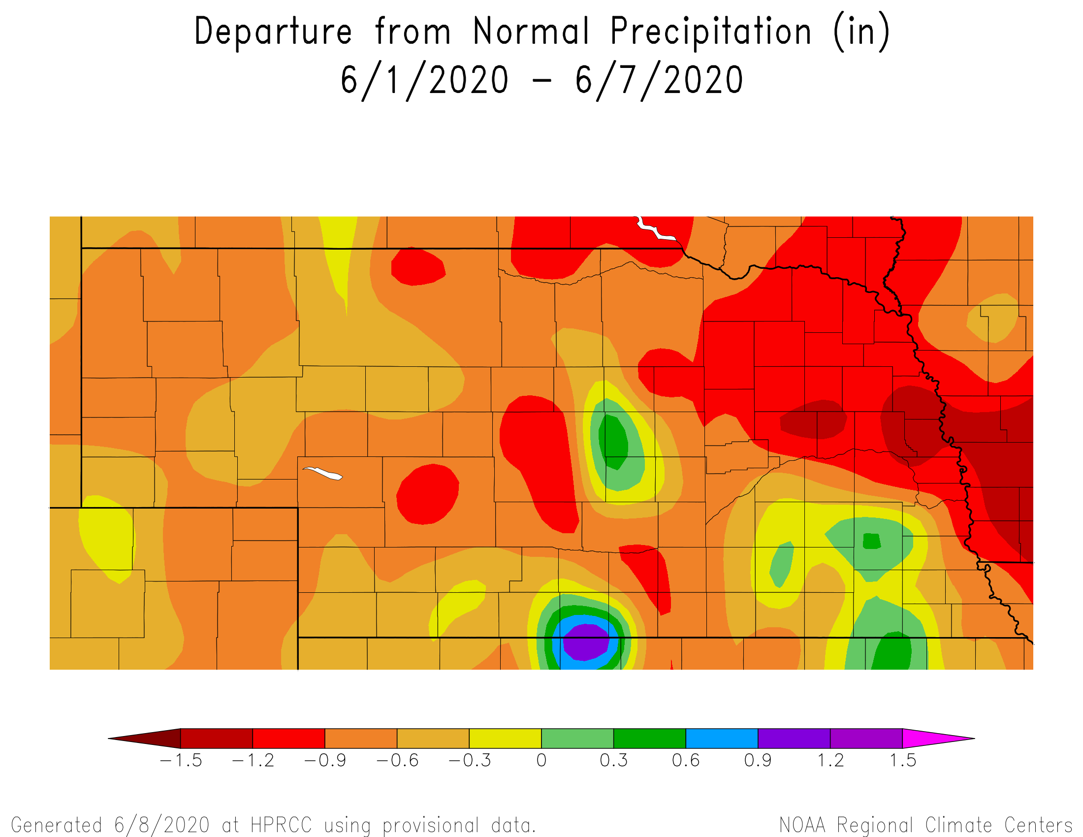
Even with such active weather across the state, precipitation this past week has been variable, with the vast majority of the state receiving below normal moisture. Figure 2 (insert fig2-2004.png) shows the precipitation departures from normal from June 2-7 were greatest across northeast and the northern half of east central Nebraska. Above normal moisture was limited to pockets of central, east central, and southeastern Nebraska.
Crop Progress
According the Nebraska Agricultural Statistics Service (NASS), pasture conditions as of June 7 stood at 2% very poor, 4% poor, 17% fair, 69% good, and 8% excellent. The monthly university beef specialist teleconference call indicated that dry conditions and declining pasture growth were a major concern, especially after a week of high winds and temperatures consistently in 90’s statewide.
So far, subsoil and light precipitation events have sustained grasslands, but deterioration was being noticed according to Extension experts. The major western U.S. trough was moving into the central U.S. at the end of this analysis period, representing the best chances for significant moisture over the next 7-10 days. Unfortunately, weather models largely project that the vast majority of moisture with this eastward moving up air trough will fall across the eastern 2/3 of the state. Further deterioration of pastures is likely with this less than optimistic outlook for areas west of North Platte.
Corn and soybean rating released by NASS ending on June 7 show corn at 20% excellent and 63% good, while soybeans were rated at 17% excellent and 65% good. According to Growing Degree Day tracking on https://cropwatch.unl.edu/gdd-etdata, corn that emerged the first week of May has reached the 6-8 leaf stage statewide and daily water use the past week averaged 0.08 to 0.10 inches per day. Corn that emerged in mid-May averaged 6 leaves, with daily water use this past week estimated at 0.06 to 0.08 inches per day.
Although short and long term dryness issues are becoming a real concern, corn and soybeans are early in their growth stages and water demands are still low. This will change dramatically over the next couple weeks as corn begins to approach full water use. Therefore, there is opportunity to replenish top soils before crop water use demands begin to exceed a quarter inch a day, if the atmosphere can cooperate.
Outlook May 8-14
The most active period during this period is forecasted to occur June 8-9 as the slow moving upper air trough crosses the central Plains and merges with the remnants of Tropical storm Cristobal over the central corn belt. This is expected to deepen the upper air trough and bring widespread moderate to heavy precipitation to the eastern half of Nebraska on June 9, before drier and seasonable weather builds into the central U.S. for the remainder of the work week.
Areas east of Nebraska will feel the brunt of Cristobal’s remnants, as widespread 2-4 inches totals area expected from the central Gulf coast regions northward into the western Great Lakes. Localized totals exceeding 6 inches are possible across portions of Missouri and southern Illinois. There will likely be an extended period of windy weather as the entire complex moves east-northeast, along with the severe weather one would expect when a strong cold front plows through the region in June.
By next week we will have a good idea of the precipitation coverage and its impacts to crops. Flooding could become a real issue and its impacts on crops that have been battling wet conditions this spring. Many of these locations have begun to dry out from the significant moisture event of mid-May and there is little available storage room in the upper profile for widespread heavy rainfall. This is particularly true for areas of southern Michigan and Wisconsin, as well as pockets of Illinois, Missouri, and Indiana).
After the frontal boundary moves through the state June8-9, seasonal temperatures will return June 10-12 under the influence of a cool Canadian air mass. Another upper air trough will build into the Pacific Northwest this coming weekend, forcing upper air ridging to take place over the central U.S. Temperatures will likely return to the 90’s until energy from this trough starts to move toward the northern Plains.
There is some evidence that during the June 13-18 period may see precipitation chances return to the central U.S., but widespread moisture is not currently forecasted. If this period turns out to be a bust, then it is likely that the next significant moisture chance will not occur until the final few days of June.
Source: Al Dutcher at Nebraska State Climate Office