March Weather Ag Impacts
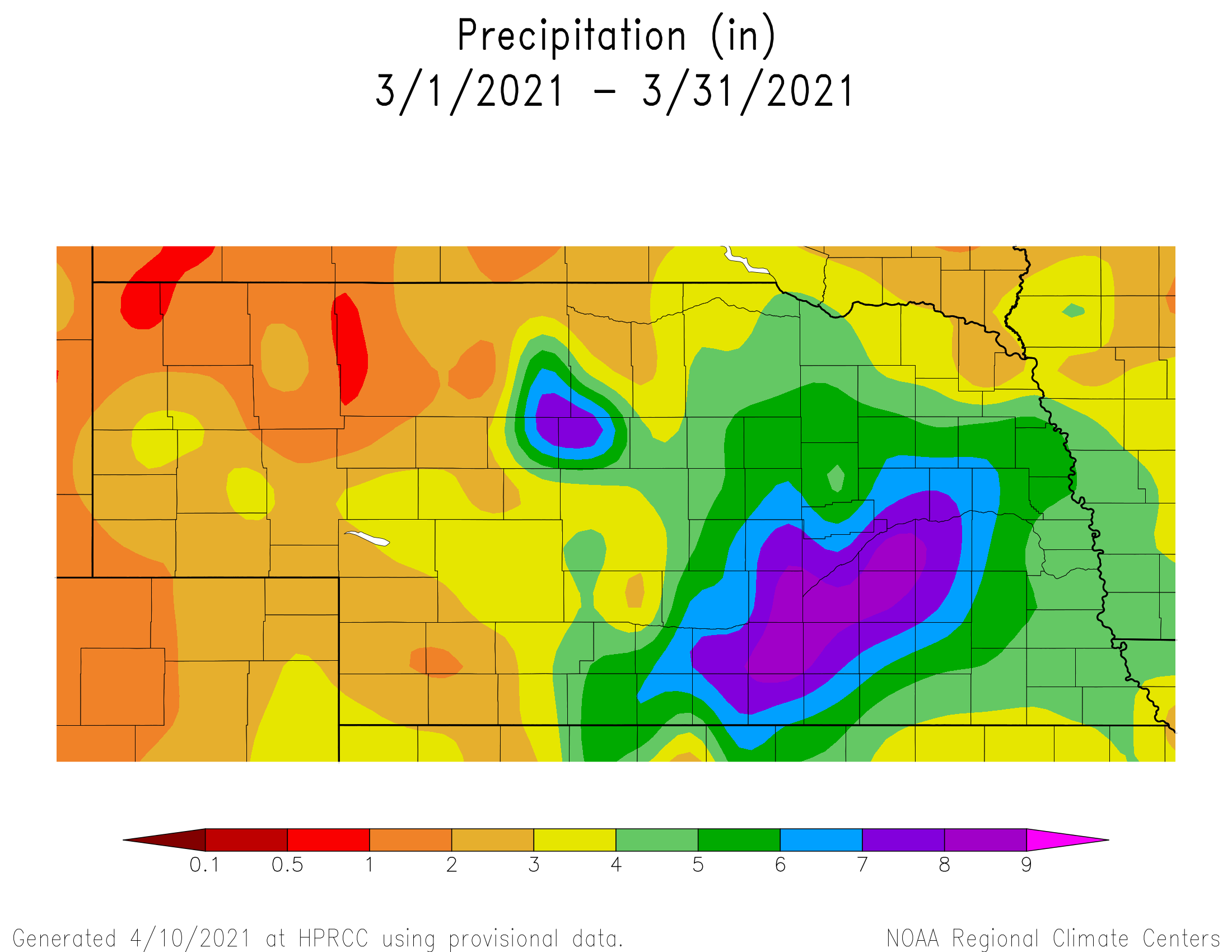
The two major storms that crossed Nebraska during March provided widespread moisture, abundantly so across central and eastern Nebraska. Blizzard conditions developed across the western Panhandle during the March 13-15th storm, while 3-8 inches of rainfall blanketed the central Platte and upper Big Blue river basins. The second storm system crossed the state March 22-23 which brought another 1-4 inches of rainfall to the eastern ½ of the state.
Figure 1 depicts the total precipitation received during the month of March. A large area of 5-9 inches of precipitation was reported from south central Nebraska east-north east through the western half of east central Nebraska. Isolated locations within this area unofficially recorded over 11 inches of precipitation. To put this moisture in context, total March moisture was the equivalent moisture normally received during the March-April (low end) or March-May (high end).
Surplus moisture during March was sufficient to eliminate precipitation deficits accumulated since October 1 across the eastern 2/3 of the state. Figure 2 shows the precipitation anomalies for March and it becomes apparent why precipitation deficits accumulated last fall were eliminated by these wet conditions. Surplus moisture of 1.50 to 7.50 inches occurred east of the Panhandle, and where these surpluses exceeded three inches, soil profiles had reached field capacity in the top 4 feet of the profile.
The benefits of the moisture received during March cannot be understated. Substantial soil moisture improvements were realized. However, the excessive moisture now puts central through eastern Nebraska in a position of potential planting delays if an active moisture pattern continues during the next 6 weeks.
Although western Nebraska moisture was beneficial, this was the first month of widespread above normal moisture since last spring. Drought conditions continue, although weakened, and several additional precipitation events will need to materialize before warm season crop planting commences to feel comfortable that the worst of the drought conditions are in the rear view mirror.
Crop Conditions – Early April Impacts
'The first days of April could characterized as warm, dry, and windy as an upper level ridge dominated the central Plains, which continued a trend established the final 5 days of March. This stretch of dry weather and above normal temperatures helped dry out wet soil surfaces and promoted cool season grass dormancy break statewide. Across the southern half of the state, trees also began leaf break by the second full weekend of the month.
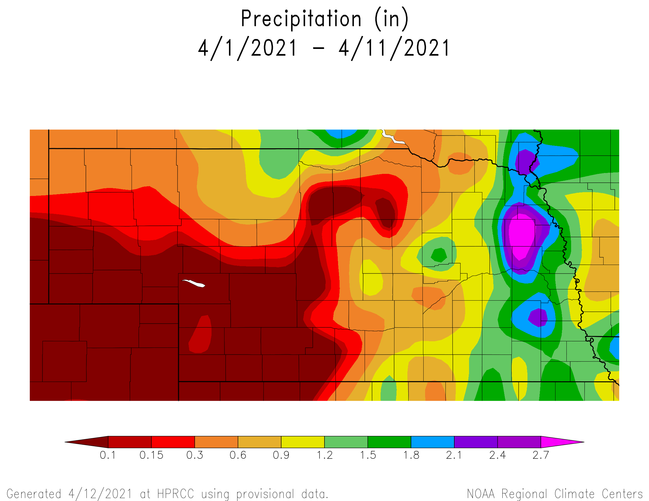
Another upper air low brought crossed the state April 6-8, which brought an end to the anomalous warmth. Figure 3 shows the precipitation impacts from this storm. One to two inches of rain was reported across the eastern ¼ of the state, with 0.25-1.00 inches from the northern Panhandle southeastward through central Nebraska. Row crop soil surfaces across the eastern ¼ of the state received enough moisture to delay field activities for 3-5 days.
The University of Nebraska monthly Beef Extension call April 12th reported that pastures were greening up statewide and there is enough moisture in the top profile for limited early season growth. Additional moisture events will be needed on a timely basis to sustain this growth into the summer. With all of the moisture during March and early April, eastern and central Nebraska feedlots are reporting that the wind and warm temperatures were drying out lots quickly and limiting muddy conditions.
Since the early corn planting insurance date for the southeastern 2/3 of the state was April 10th, there has been little planting activity reported by Nebraska Agricultural Statistics Service (NASS). Even though temperatures in Figure 4 have averaged 3-10 F above normal for the month, the April 6-8 low pressure system pulled below normal temperatures into the state the past 3 days. High temperatures have struggled to break the 65 F mark and low temperatures were consistently in the upper 20’s to mid 30’s.
The only planting that has broken the one percent mark are oats and NASS reports that as of April 11 that 40% of the crop has been sown. This compares to 30% last year and the 5-year average of 33 percent. Eight percent of the crop has emerged, which compares to 4% last year and the 5-year average of 5 percent.
NASS only issued two condition reports this week, soil moisture and winter wheat conditions. Winter wheat as of April 11th is reported as 6% very poor, 13% poor, 38% fair, 41% good, and 2% excellent. Wheat conditions are poorest across the southwest and southern Panhandle.
Statewide topsoil moisture is rated 5% very short, 15% short, 74% adequate, and 6% surplus. Subsoil moisture is rated 9% very short, 24% short, 65% adequate, and 2% surplus. The southwest and panhandle regions represent the vast majority of area contributing to the very short and short categories in the topsoil and subsoil ratings by NASS.
Weather Outlook
The cool air that is in place currently across the central and northern Plains is expected to continue through this weekend. Unfortunately, as the upper air low over the northern Plains drifts eastward toward the Great Lakes, a piece of energy rotating around this low will drop into the central Rockies and cutoff. This low is expected to slowly move east-southeast into the southern plains this weekend.
The path of this upper air low will be dictated by how quickly the upper air low over the Great Lakes moves toward the northeastern United States. Currently the GFS model indicates that the precipitation shield with the upper air low over Colorado will primarily impact the southern Panhandle and southwest Nebraska with 0.50-1.25 inches of moisture. Precipitation totals are projected to tail off to less than a quarter inch or less east of south central Nebraska.
The GFS model is currently indicating that upper air ridging will build into the central United States April 18-22. High temperatures should return to the mid 60’s to mid 70’s during this period, with the coolest highs occurring across the northeastern corner of the state. Several glancing blows of cool air will southward along the front side of the upper air ridge, giving a glancing blow of cool Canadian air with no appreciable moisture expected.
Considerable uncertainty exists in regards to the upper air pattern beginning April 23 and running through the end of the month. The GFS model has been advertising the past couple of days that there will be a system crossing the state the April 23-24, then bringing warm and dry conditions for the remainder of the month. This morning GFS model run has now flipped to a wetter and colder pattern developing during the final 7 days of the month.
The GFS model now moves the April 23-24 trough east of the state and replaces it with another trough over the central Rockies. This system begins to move east across the central Plains April 25-27 according to the GFS and develops widespread moisture across the entire state. The GFS then indicates that a surge of cold air will move south out of Canada to end the month, with possible frost/freeze conditions developing across the Dakota’s and the northern half of Nebraska.
If the current GFS forecast verifies, the best widespread planting conditions will likely be from April 18-23, before rainfall and cool temperatures bring less than ideal planting conditions the final week of the month. However, if the GFS reverts back to the forecast the past few days, then warm and dry conditions (perfect planting weather) will dominate the western corn belt into early May.
Al Dutcher, Agricultural Extension Climatologist, Nebraska State Climate Office


