Weather Update
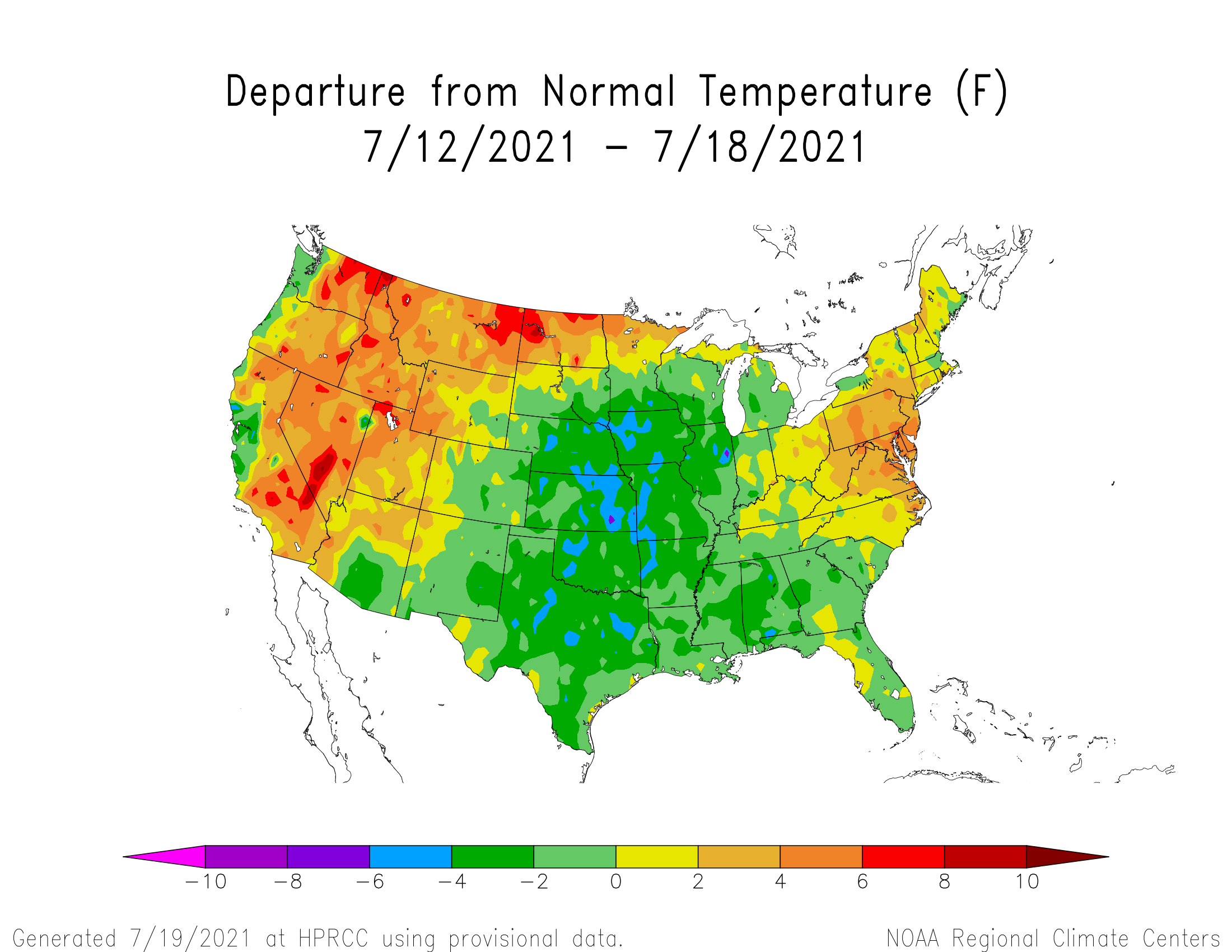
Atmospheric ridging dominated the western United States, with a broad upper air trough situated over the northern Plains and western Great Lakes. As this ridge slowly shifted eastward, above normal temperatures returned to the Panhandle during the second half of last week. Further east, above normal temperatures held off until this past weekend. Average temperatures for the July 12-18 period were below normal outside of the extreme northwestern corner of the Panhandle (Figure 1).
As this ridge slowly built eastward, impulses of energy moved along the intersection of ridge and trough which resulted in several rounds of thunderstorms that hit portions of drought stricken north central and northeast Nebraska. One to 3 inches of moisture was reported in the northeastern Sandhill region and the eastern Niobrara river valley. However, long term deficits (9 -12 months) are in the 6-12 inch range and deep subsoil moisture is nonexistent. If high temperatures and below normal moisture are realized over the next two weeks, there will likely be corn pollination and early grain fill issues.
According to the NeRain observers, In addition to the northeastern Nebraska thunderstorm activity, weekly precipitation totals of 2-4 inches fell in small areas south and east of Beatrice, between Maxwell and Farnum, in the immediate Holdrege area, as well as south and west of Yankton, South Dakota. What is notable from the NeRain data is these precipitation events exhibited high variabity over short distances and above normal moisture was limited to north central, northeast, central, and south central Nebraska (Figure 2).
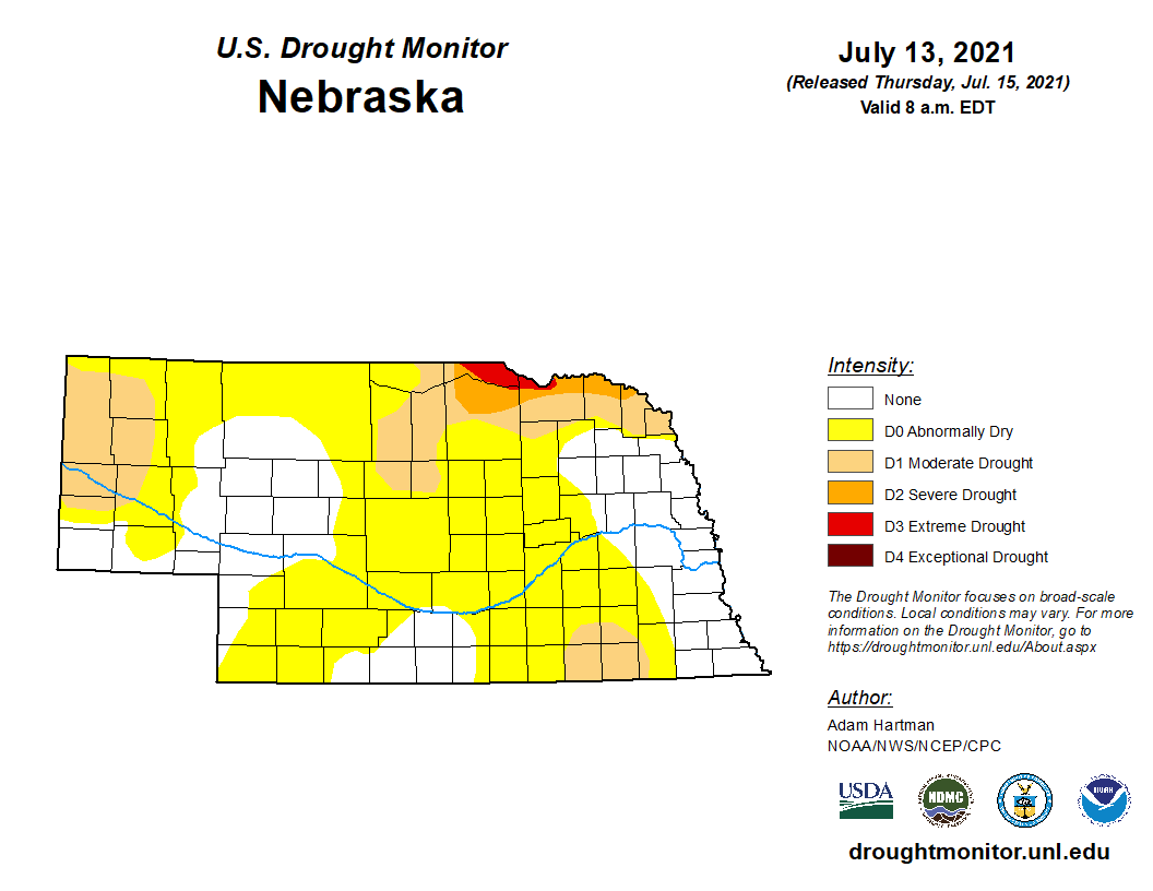
The latest Drought Monitor depiction for Nebraska (Figure 3) which reflects conditions as of July 13 show pockets of moderate drought (D1) across the west central and northwest Panhandle, the northeastern Sandhill region, the South Dakota border counties along the Missouri river and the Fairbury to Hebron area. Severe (D2) to extreme (D3) drought is currently confined to eastern Niobrara river valley, primarily north of the river and the northern 1/3 of the South Dakota border counties of northeast Nebraska.
Warm season crops are now in their maximum water use phase as crops begin to enter pollination and/or the early grain fill period. Typical daily water use during this time of the year ranges from 0.25 inches/day across eastern Nebraska to 0.30 inches/day for the western half of the state. If maximum temperatures are consistently in the upper 90’s and low 100’s, an additional 0.05 to 0.10 inches/day can be added on to these daily water requirements.
Precipitation during late July averages between 0.75 inches (west) to 1.25 inches (southeast). Even with normal moisture, crop water demands under average conditions will deplete stored soil moisture (without supplemental irrigation) an average of 0.75 inches/week (southeast) to 1.25 inches/week (western 1/3 of Nebraska). With a less than promising precipitation forecast over the next two weeks and a high probability of maximum temperatures consistently above 95 through much of the remainder of July, a rapid expansion of abnormal dryness to moderate drought conditions will likely develop west of a line from Sioux City to McCook.
On a more optimistic note, the monsoon season in the southwestern desert region has been strong and may be the wild card in the outlook for precipitation heading into the beginning of August. If the northern extent of the high pressure ridge projected to dominate the western corn belt for the next 10 days gets pushed southward in response to an atmospheric trough moving across the northern Plains, then monsoon moistures will lift northeast around the ridge periphery toward the central High Plains (northern ½ of Kansas to the southern ½ of South Dakota.
Crop Progress
With above normal moisture reported during the past week across north central and northeast Nebraska, as well as pockets of central and south central Nebraska, warm season crop conditions improved slightly. Nebraska Agricultural Statistics Service (NASS) reports that as of July 18 the corn crop was rated 78% good to excellent compared to 77% last week. Soybeans were rated 81% good to excellent compared to 79% last week and sorghum was rated 81% good to excellent compared to 80% last week.
NASS reports that 54% of the corn crop had reached the silk stage compared to 19% last week. A year ago 55% of the crop had reached the silk stage and the 5-year average stands at 55 percent. The majority of the corn crop that has not reached the silk stage is located across the northwestern ½ of Nebraska.
Seventy-four percent of the soybean crop had reached the bloom stage as of July 18th according to NASS. Last year 72% of the crop had reached this stage and the 5-year average stands at 62 percent. In addition, soybeans setting pods was 16% compared to 12% last year and the 5-year average of 4 percent. An overwhelming majority of the sorghum crop was still in the vegetative stage, but NASS reports that 3% of the crop was now headed compared to 11% last year and the 5-year average of 9 percent.
The above normal rainfall during the last week across northern, as well as parts of central and south central Nebraska resulted in a sizeable improvement in topsoil moisture conditions. NASS reports that 4% of the state topsoil moisture is very short, 27% short, 67% adequate and 2% surplus. There was a 4 percentage point reduction in the very short category from last week and a 5 percentage point reduction in the short category. The percentage of topsoil that NASS classifies as having adequate soil moisture improved 10 percentage points.
Subsoil moisture rating improvements were not as significant topsoil ratings over the past week, but there were improvement none the less. NASS reports that 7% of the subsoil across the state was classified as very short, 34% was short, 58% was adequate and 1% was surplus. Compared to last week, the very short category improved one percentage point, the short ratings declined 4 percentage points, the adequate rating improved 5 percentage points and the surplus rating remained unchanged.
The winter wheat harvest was 23% complete as of July 18 according to NASS, which compares to 45% last year and the 5-year average of 40 percent. Crop condition ratings have shown little movement during the past couple weeks as most of the crop is now mature and waiting to be combined. NASS reports that 2% of the crop is very poor, 8% poor, 30% fair, 59% good and 10% excellent.
If the GFS model in correct in its depiction of temperatures and precipitation through the first full week of August, then crop ratings declines are likely for corn as it attempts to pollinate and begin the early grain fill process, The portion of the corn crop that will be most vulnerable to heat and dryness over the next two weeks includes northeast Nebraska along the South Dakota border and in the Fairbury to Hebron region. However, pivot corners and corn under irrigation where well output is less than 600 gallons per minute will also be vulnerable to soil moisture declines and as crop water use exceeds what manmade and natural moisture fail to provide.
Weather Outlook
The GFS model forecast from July 21 – August 6 indicates that the atmospheric ridge that began to shift toward the central Plains during the second half of last week will become firmly entrenched over the central and northern High Plains this week. The GFS does indicate that a couple of shortwave troughs will move across the northern Plains and slightly deform the northern portion of the ridge southward July 25th, July 29th and August 1-2. In each instance, air temperatures are projected to decrease 5-10 F for little more than a day at a time.
The GFS model currently projects maximum temperatures will consistently reach the upper 80’s to low 90’s across eastern Nebraska July 21-26, with low to upper 90’s west. Maximum temperatures are likely to exceed 100 F July 23-24th in pockets of western Nebraska. Slight cooling is projected July 25-26 east in response to a short wave moving across the northern Plains, then builds it southward as it reaches the western Great Lakes. This would lead to a brief visit to the upper 80's across the northeastern 1/4 of the state.
From July 27-31, the GFS model indicates that the 588 millibar thickness level (used to identify areas likely to exceed 100 F) will be situated over southwest through central Nebraska. Widespread upper 90’s to low 100’s are likely for most of the state based upon current model output. The GFS model does indicate a slight cool down August 1-4 of 5-7 F before the 588 millibar thickness line is forecast to return to the western 1/3 of the state. Thus a return to maximum temperatures in the upper 90’s to low 100’s is possible. Eastern Nebraska will be slightly cooler according to the GFS model and high temperatures are forecast to cool back into the upper 80’s to low 90’s.
Unfortunately, precipitation looks weak to nonexistent for much of this forecast period. Naturally, the best opportunities for moisture will exist when short wave troughs move across the northern Plains. Any convection that is able to break the atmospheric cap will quickly become severe, with hail and high winds the primary threats. Dew point temperatures will move into the 70’s over eastern Nebraska this weekend, with upper 50’s to low 60’s across the western 1/3 of the state. Any thunderstorms that do develop will be capable of producing heavy rainfall over short periods of time.
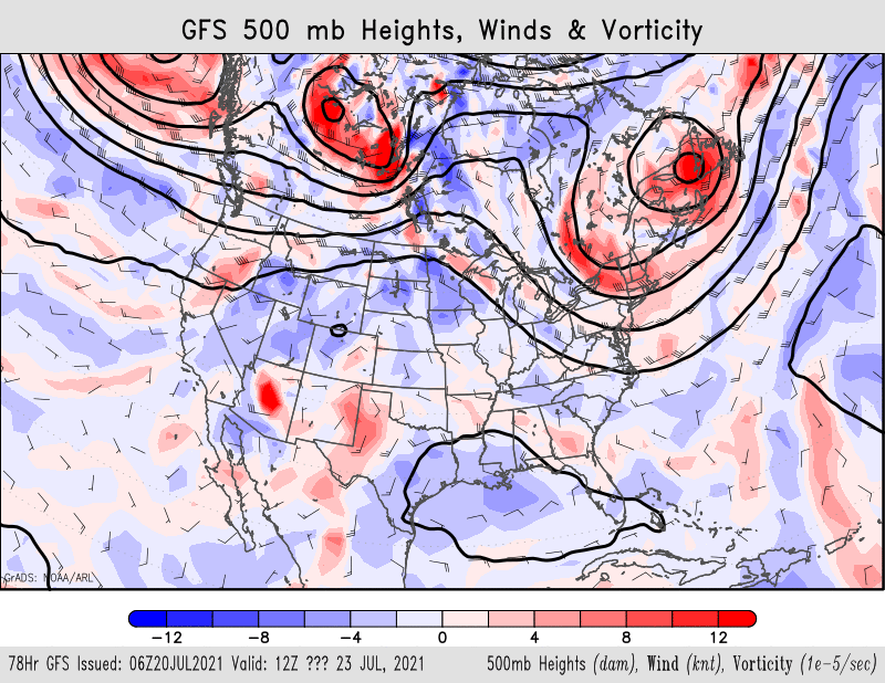
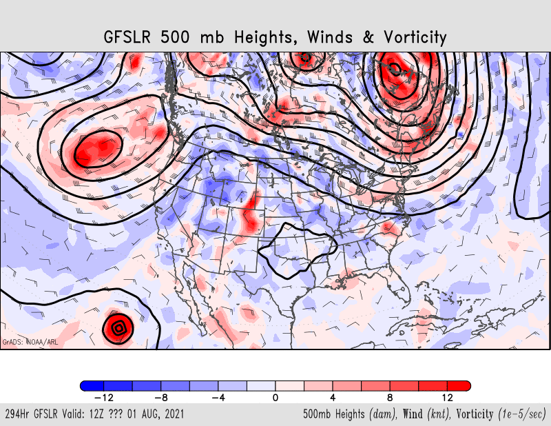
Figures 4 and 5 show the GFS upper air pattern for the morning of July 23 and August 1. In both figures, the atmospheric ridge is positioned close to Nebraska with the biggest difference being that August 1 ridge position would allow for monsoon moisture to be lifted northeastward toward the back side of the surface high associated with the upper air ridge. With a large atmospheric trough pushing into the west coast, there should be an increase in monsoon moisture moving northeast into the central Rockies ahead of this trough. If this does happen, there may be a glimmer of hope that the first week of August will become more active then currently depicted by the GFS model.
One thing that has a high probability of occurring is that oppressive heat will build into the central Plains during the next 7-10 days and dew point temperatures will consistently exceed 70 F over the eastern half of the state. Heat indices for humans and cattle will likely approach or exceed 115 F on days where maximum temperature reach the upper 90’s or beyond.
The dew point may actually rise into the middle to upper 70’s across the eastern half of the state July 28-30, which may keep nighttime low temperatures above 75 F across the eastern 1/3 of the state July 26-29.. If nighttime temperatures are consistently above the low 70’s, corn doesn’t respire efficiently during the nighttime hours. Thus, the grain fill period progresses faster than normal and yields usually responded negatively.
Al Dutcher, Agricultural Extension Climatologist, Nebraska State Climate Office


