Highlights
August 2023 in Nebraska was around average for precipitation and slightly above average for temperature. That sentence is true from a statistical standpoint but also isn't close to the whole story. During the month, we managed to have drought relief in eastern Nebraska, an early taste of fall, a record setting heat wave, and a perfect late summer night in Lincoln for the world record crowd at the volleyball match on the 30th. At the beginning of the month, temperatures were mild over most of the state and precipitation was bountiful in northeastern Nebraska and southwestern Nebraska. After the 14th of August, much of the state went bone dry. Exceptions were the panhandle and most of south central and southeastern NE , which had a significant amount of rain late on the 25th into the morning hours on the 26th.
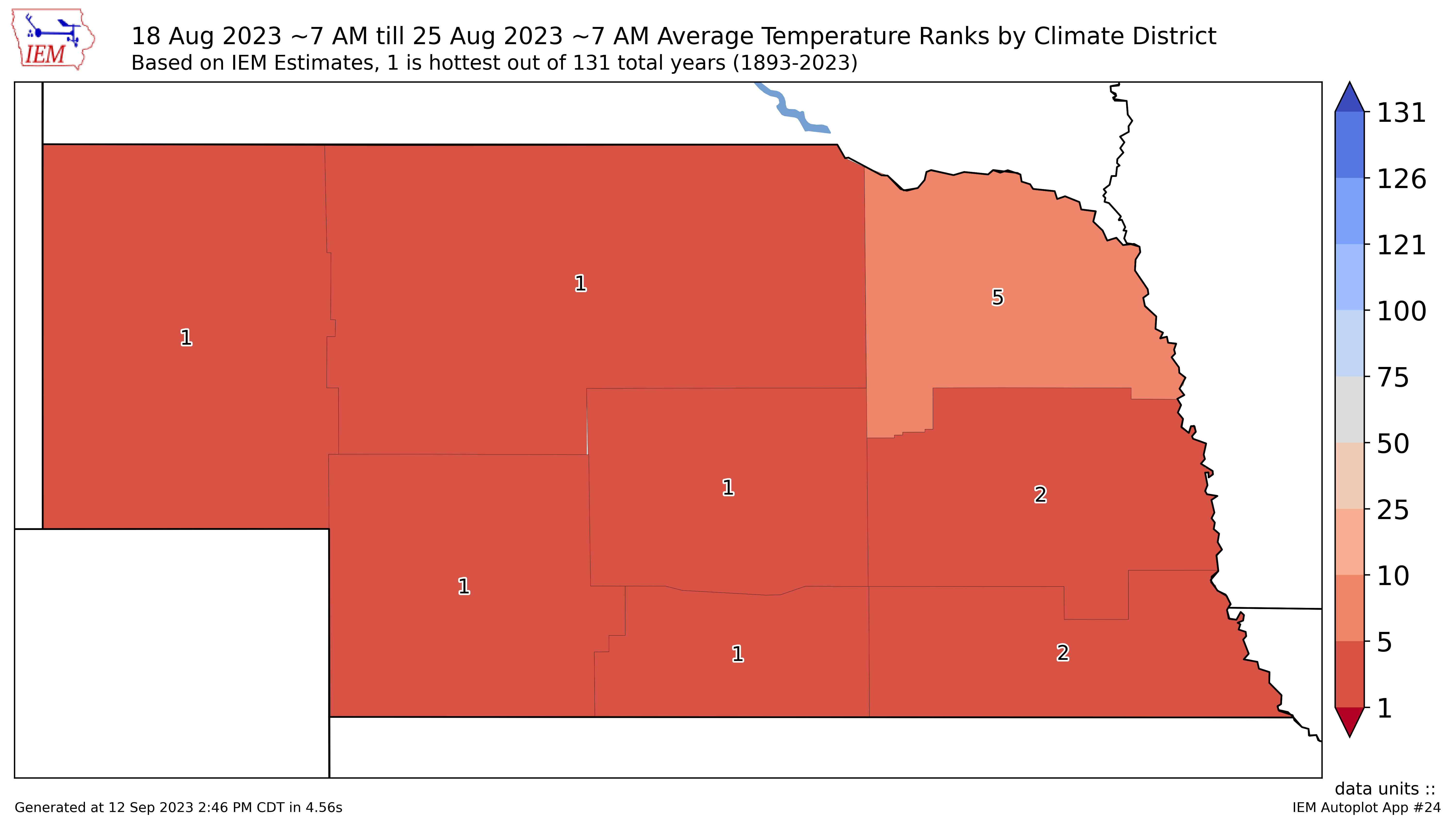
The heat started ramping up in western Nebraska on the 16th and encompassed the whole state by the 19th. The week of August 19-25th was the hottest week for the state in many years, with most locations hitting or exceeding 100F on multiple days. In the eastern section of the state, these abnormally high temperatures and full sunshine were combined with high humidity and low wind speeds to create very dangerous conditions for humans and livestock alike. The cattle comfort index (CCI) reached the extreme danger category on at least one day at almost every Nebraska Mesonet station along and south of I-80 (Kearney east) and 3-4 days at stations in York, Saline, Lancaster, and Johnson counties. Heat index values were over 110F were common in the afternoon and evening for several days and Omaha had its highest daily average heat index on August 22nd (101.8F). Lincoln's was a close second on the 22nd. This heat wave was brought on by a record strong mid-level ridge of high pressure, which helped keep that hot, crop-aided moist air in place near the surface for several days.
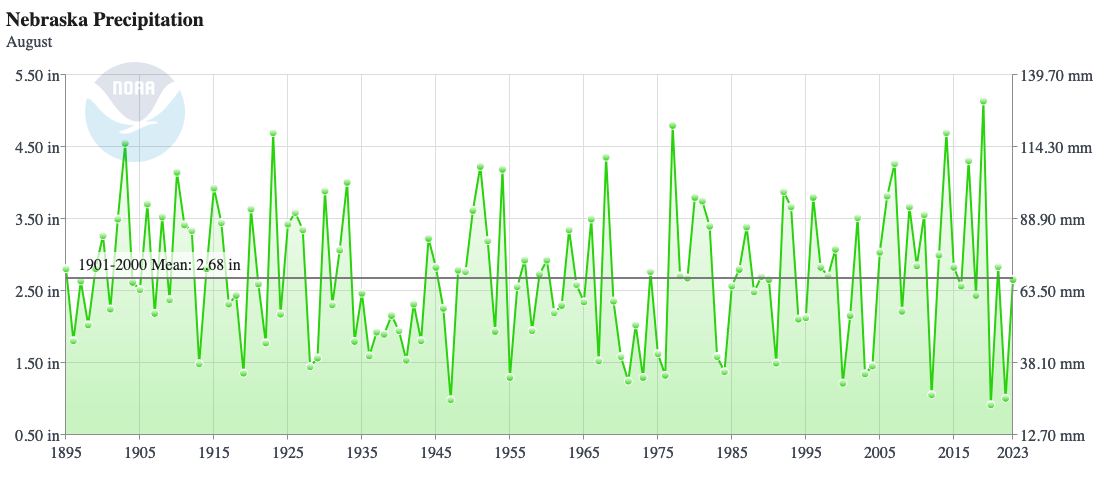
Precipitation
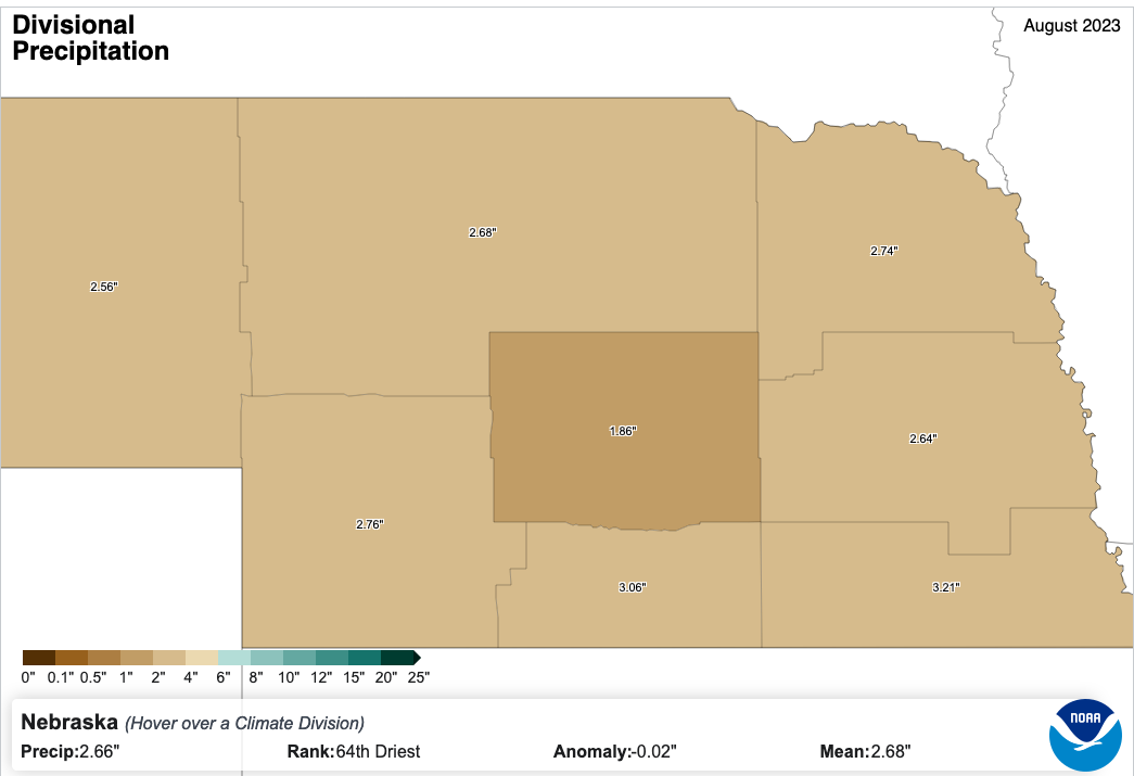
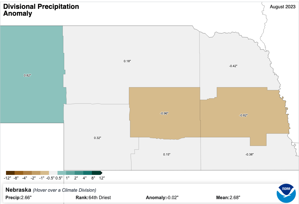
Statewide precipitation was essentially right at the long-term average in 2023 with no climate divisions having anomalies greater than an inch (positive or negative). But precipitation in the month was not evenly distributed temporally. For most of the northern half of the state, it was very dry from August 15th through the end of the month with many places not picking up any rainfall. The precipitation that occurred in the first half of the month was enough to bring improvement on the U.S. Drought Monitor for sections of north central and northeastern Nebraska. Remnants of Tropical Storm Harold interacted with the slow moving cold front that ended the heat wave late on the 25th and 26th to produce a mesoscale convective vortex, which led to widespread 1.5-3" rainfall totals for much of south central and southeastern Nebraska. This allowed for additional drought relief and removal in southeastern Nebraska. By the end of the month, only half of the state was in drought and 30 percent was free of drought and abnormal dryness.
Below are divisional average precipitation totals and anomalies. Largest positive anomalies were found in the Panhandle climate division and central Nebraska was the driest relative to long-term normals. No climate division had a top-10 wettest or driest August.
Panhandle 2.56" (+0.82")
North Central 2.68" (+0.18")
Southwest 2.76" (+0.32")
Central 1.86" (-0.96")
South Central 3.06" (+0.15")
Northeast 2.74" (-0.42")
East Central 2.64" (-0.82")
Southeast 3.21" (-0.38")
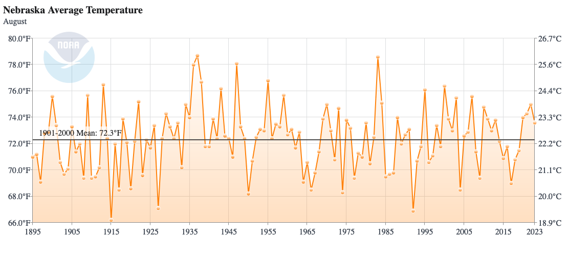
Temperature
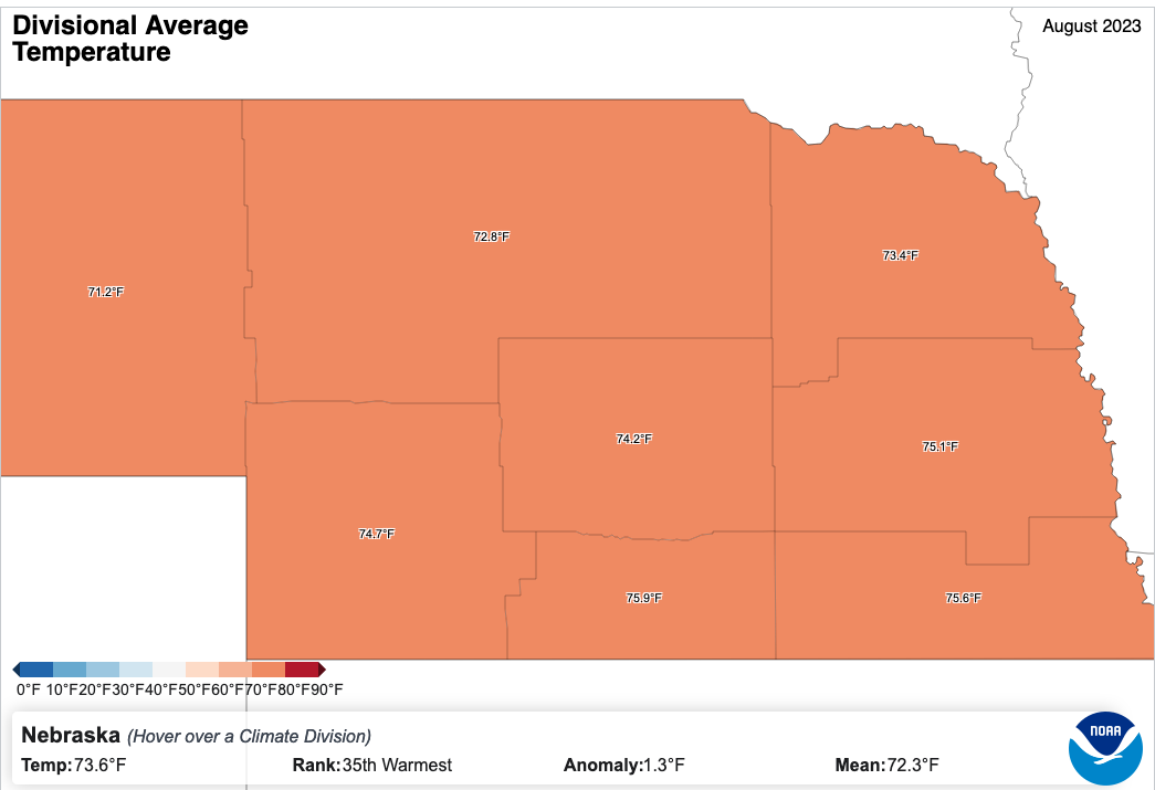
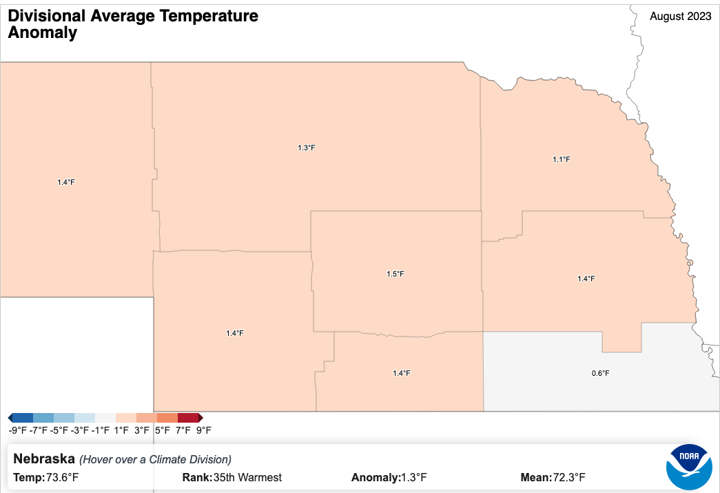
Temperatures were above long-term normals in August but nowhere close to record levels. Temperatures across the state were above normal largely because of the week of August 19-25th and what a 7-day period that was. It was the hottest common period on record (1893-present) for the Panhandle, Central, North Central, Southwest, and South Central climate divisions. The eastern districts came in 2nd or 5th. Prior to the heat wave, most of northern and eastern Nebraska enjoyed a brief taste of fall weather with highs in the 70's and lows in the 40's and low 50's. Some parts of eastern Nebraska went from lows in the 40s on the morning of the 18th to heat index values around 120F less than 36 hours later on the 19th. Otherwise temperatures in the state generally remained within 5 degrees of seasonal averages most days in August 2023 outside the aforementioned periods.
All climate divisions were above long-term averages, with every division but Southeast Nebraska coming in at +1.0-1.5F. No division had a top 10 warmest August.
Panhandle 71.2 F (+1.4 F)
North Central 72.8 F (+1.3 F)
Southwest 74.7 F (+1.4 F)
Central 74.2 F (+1.5 F)
South Central 75.9 F (+1.4 F)
Northeast 73.4 F (+1.1 F)
East Central 75.1 F (+1.4 F)
Southeast 75.6 F (+0.6 F)
Agricultural Update
While the month did bring drought relief to parts of the state, the last 10 days of the month took a toll on crops and livestock across almost all of the state. The heat wave starting in mid-August and dry finish to the month for much of northeastern and central Nebraska brought down condition ratings on corn and soybean. This was evident on the VegDRI maps, which showed deteriorating conditions in the last part of August after several weeks of depicting improving vegetation conditions prior to the heat wave. The heat accelerated the reproductive stages of corn and soybean with corn starting to mature in parts of Nebraska by the end of the month. Pasture condition ratings improved in the first half of the month, a continuation of a trend that started in May, but started to slide late in the month. USDA estimates released on August 11th put corn and soybean yields in Nebraska at 185 and 58 bpa respectively. Those numbers are likely quite optimistic given the rough finish but corn is still likely to finish above 2022 levels. Soybean likely will come in around last year's numbers on yield.
August Mesonet Extremes
Highest Air Temperature: 106 F Guide Rock 3E (21st)
Lowest Air Temperature: 41 F Harrisburg 1 N (14th)
Highest Heat Index Temperature: 129 F Rulo 5SW (19th)
Lowest Wind Chill Temperature: 38 F Harrisburg 1 N (14th)
Maximum Wind Gust (3 meters): 57 mph Alliance 6NW (4th)
Maximum Wind Gust (10 meters): 64 mph Wilber 1W (6th)
Highest Daily Precipitation: 2.67 inches Oakland 4W (3rd)
Highest 4 Inch Soil Temperature: 102 F Lincoln 1500 N 45th (24th)
Lowest 4 Inch Soil Temperature: 60F Whitman 5NE (29th)
CoCoRaHS Extremes
Maximum and minimum precipitation in the state in August 2023 as reported CoCoRaHS observers. Note that only observers with 100% data completeness for the month were considered
Maximum precipitation: 7.42" at chey025 in Cheyenne County
Minimum precipitation: 0.79" at NE-MP-1 in McPherson County
Eric Hunt, University of Nebraska Extension and Nebraska State Climate Office