Highlights
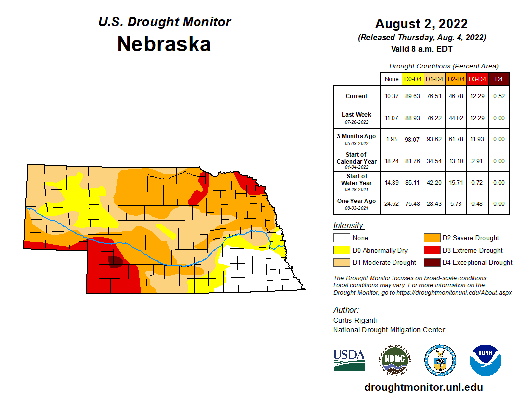
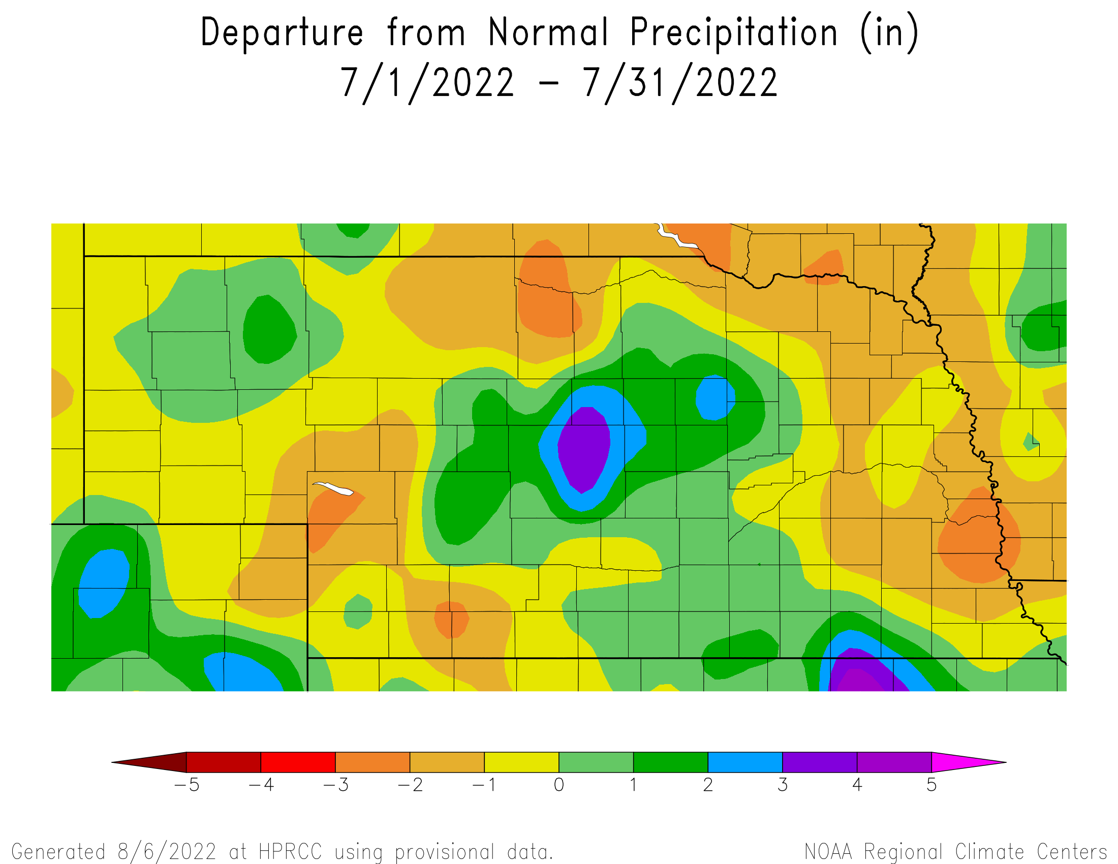
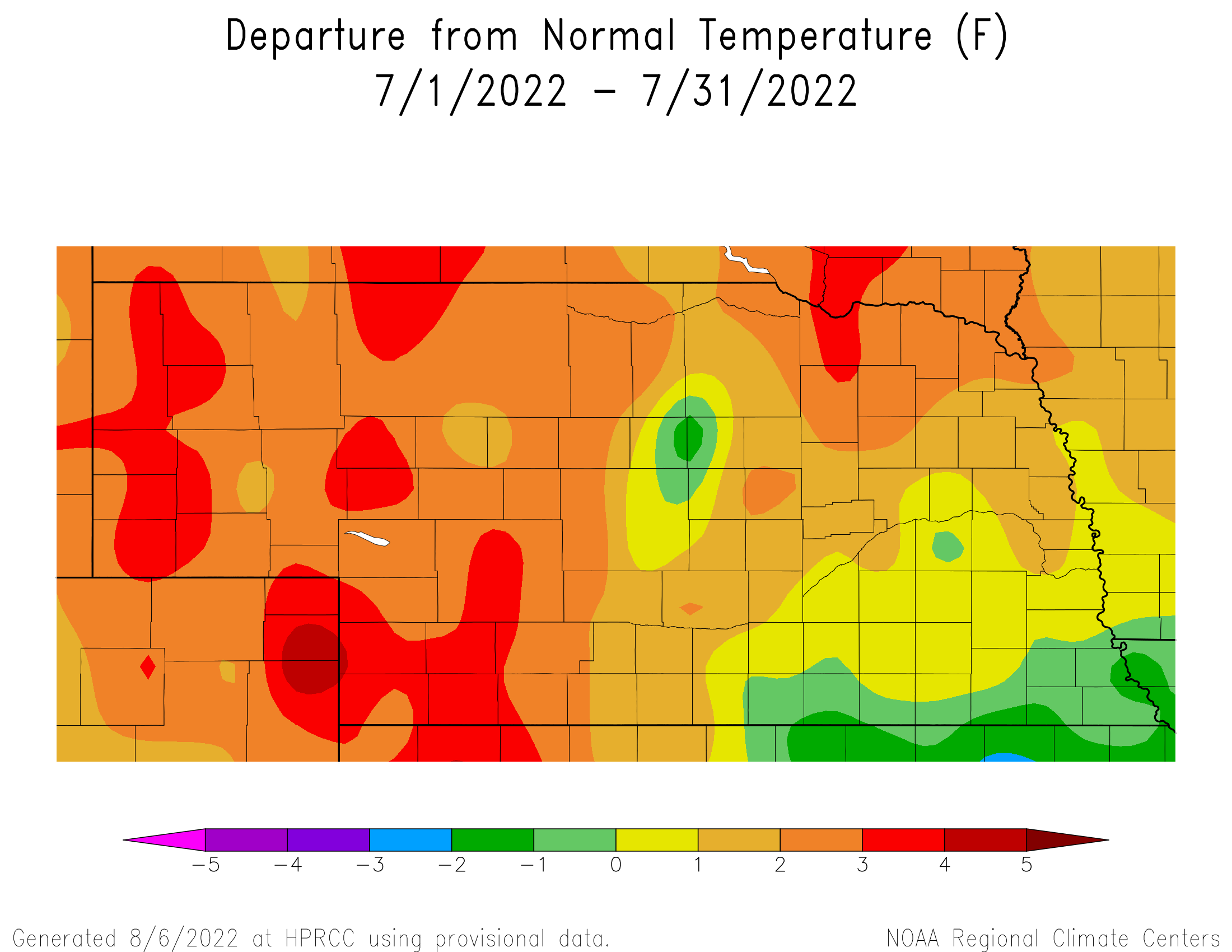
Nebraska started August with 76% of the state in drought conditions, according to the U.S. Drought Monitor. Conditions vary across the state as the far southeast remains drought free, for now, while the southwest and northeast corners are bearing the brunt of the highest precipitation deficits. For July on the whole, rainfall was above normal for a portion of the northwest, central and southeast. Elsewhere, conditions were half inch to two inches less than normal. Temperature departures were highest in the west and northeast at three degrees above normal. Aside from this, temperatures were in the near normal range.
Precipitation and Drought
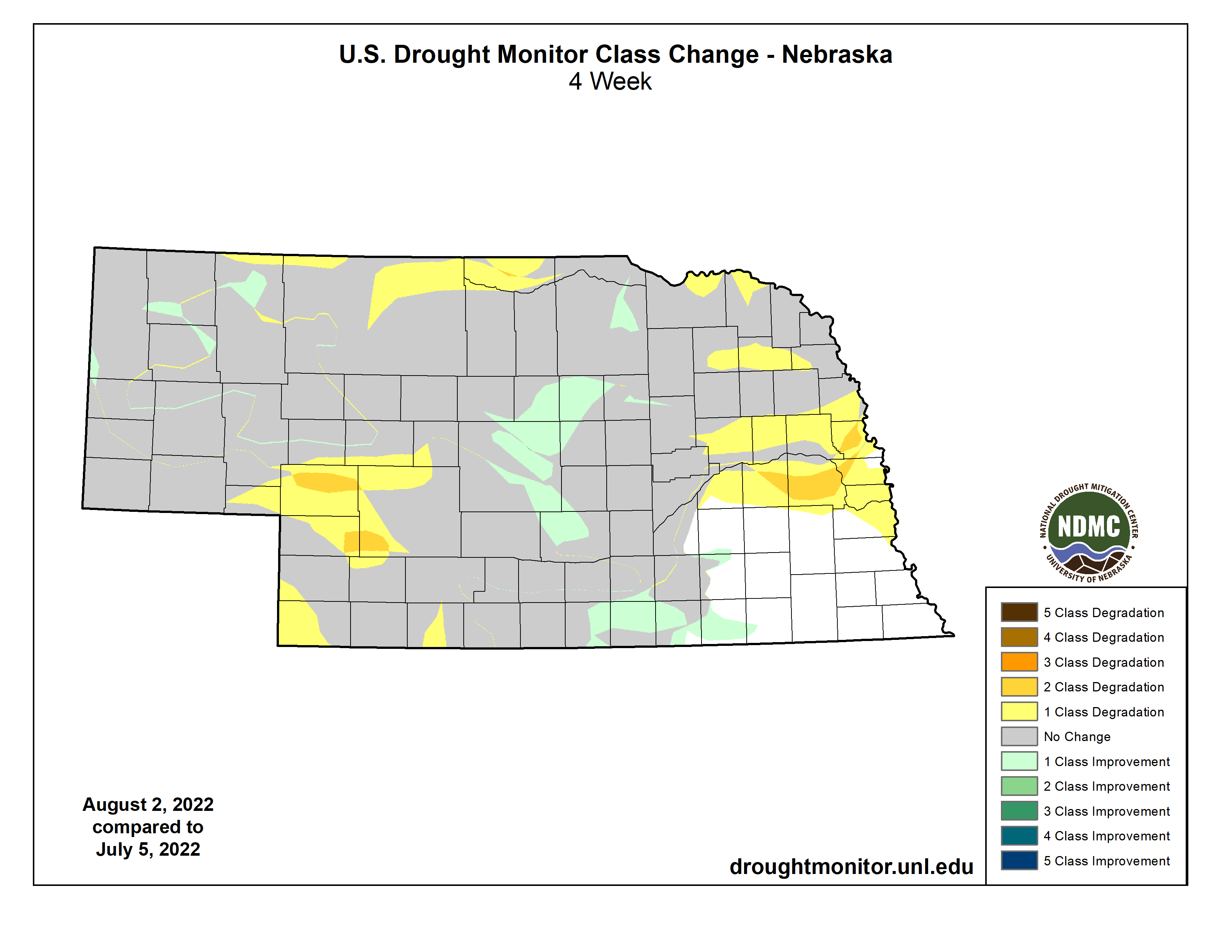
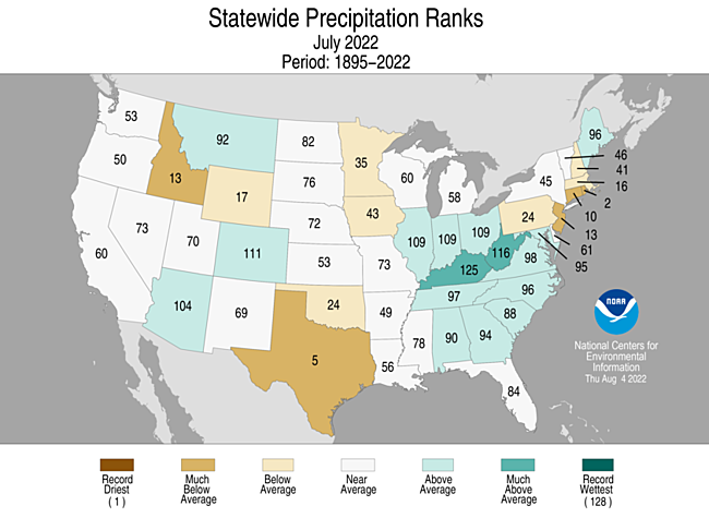
Rainfall conditions were mixed around Nebraska this July. Some localized areas of heavy precipitation fell in central and southeast portions. Observers south of Fairbury reported more than eight inches, with 8.72 reported at Superior. Central Nebraska, generally around the Broken Bow area, received greater than six inches. Anselmo, Berwyn and Ord reported 7.3 to 7.5 inches. On the dry side, locations in Sarpy, Cass and Otoe counties in the southeast, Wayne and Stanton counties in the northeast, and areas of the southwest, west and north central all reported an inch or less rainfall for the month. On a statewide basis, the average precipitation totaled three inches, which is a little less than a quarter inch below normal for July. The past thirty years have generally seen a decreasing trend in rainfall, with the long-term trend over the last century holding relatively steady. Drought conditions overall have worsened during July, particularly for the east and west central. In these areas, we have seen one and two class degradations in the U.S. Drought Monitor classification. Year to date precipitation deficits for areas with severe drought or worse (D2) are in the six to ten inch range, or about half of normal precipitation thus far in 2022.
Temperature
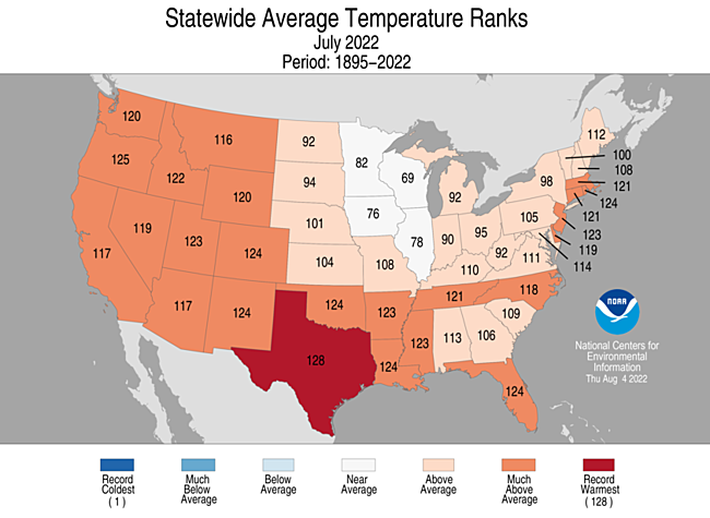
The most notable aspect for temperatures this July was the relative propensity of triple digit heat. Areas in southwest Nebraska topped out above the 100 degree mark for nearly two weeks. Benkelman, Culbertson, McCook, Imperial and a few other locations reported high temperatures above 100 for 10 - 13 days, and above 105 for five days. Few daily high temperature records were broken, however, 108°F on the 18th at Valentine being one. The high for the month was 111°F, observed at several locations around the west. All reporting stations reached at least 95°F. The monthly statewide low of 43°F was reported in northwest Nebraska, though the low for most locations was in the 50s. The statewide average temperature of 76.4°F is two degrees above normal for July and is several degrees behind the 80°F average of 2012. Over the past century, temperatures in July have not changed significantly. Though in recent decades, temperatures have generally trended warmer.
Severe Weather
Compared to June, severe weather during July across Nebraska was nothing less than subdued. Preliminary statistics from the Storm Prediction Center indicates that there were 36 hail and 113 wind storm reports issued by trained spotters during July. Two tornados were observed, one near Grand Island and one near Roscoe. In comparison to last month, the SPC storm data base indicated that 292 hail, 196 wind storm and 10 tornado reports were submitted. Naturally, when storm reports drop this dramatically from one month to the next, it is very likely that there has been a reduction in systems moving through the central United States that would provide a focal point for severe weather development. This is also a convoluted way of saying that reduced precipitation activity, coupled with above normal temperatures increased drought stress as the month progressed.
Agricultural Update
Using the Nebraska Agricultural Statistics Service (NASS) crop condition report comparisons, corn in good to excellent condition dropped from 62% July 3rd to 54% on July 31st. Soybeans were a little more resilient as the amount of crop in good to excellent condition dropped from 61% to 57% over the same time period. The state sorghum crop appears to have suffered the greatest declines in crop health of the warm season crops grown in Nebraska. NASS reports that 63% of the crop was rated good to excellent on July 3rd, but dropped to 36% on July 31st. Southwest Nebraska is the largest sorghum growing region in the state and currently has the largest area of D3 (extreme) drought of any area of the state. Pasture conditions were already severely impacted from dry conditions at the beginning of July when NASS reported that 56% of crop was estimated to be in poor to very poor condition. By July 31st, the percentage of the crop listed as poor to very poor had increased to 62 percent. Topsoil and subsoil moisture readings rated good to excellent on July 3rd was 40% and 41%, respectively. These numbers decreased 25% by the end of the month with good to excellent conditions for topsoil estimated to be 30% and subsoil was estimated to be 31 percent.
Outlook
The Climate Prediction Center (CPC) issued their official August temperature and precipitation outlooks for the United States on July 31st. Nebraska is currently forecast to receive above normal temperatures and below normal precipitation during the upcoming month. Compared to their preliminary August temperature outlook issued July 21st, CPC has increased the odd of above normal temperatures across the northeast _ of Nebraska, while decreasing odds slightly for western Nebraska. The northeast 2/3 of the state ae depicted as having 50-60% odds of above normal temperatures, 33% odds of normal temperatures and 7-17% odds of below normal temperatures. Except for the southwestern corner of the Panhandle, the remainder of the state has been assigned above normal temperature odds of 40-50%, normal temperature odds of 33% and below normal temperature odds of 17-27 percent. There is a 33-40% likelihood of above normal temperatures across the southwestern corner of the Panhandle.
The August official precipitation outlook is closely aligned with CPC’s preliminary outlook, which calls for a 33-40% chance of below normal moisture, a 33% chance of normal moisture and a 27-33% chance for above normal moisture. Only the southwest corner of the Panhandle has equal chance to receive above normal, normal or above normal precipitation. CPC has increased their odds for above normal moisture for the southern Great Basin due to a continuation of a strong monsoon moisture season. At the same time, they shifted their highest probability of below normal moisture in their preliminary August outlook from the central corn belt and western Great Lakes region to the southern High Plains region centered on western Arkansas, northeastern Texas and the eastern 2/3 of Oklahoma.