
Highlights
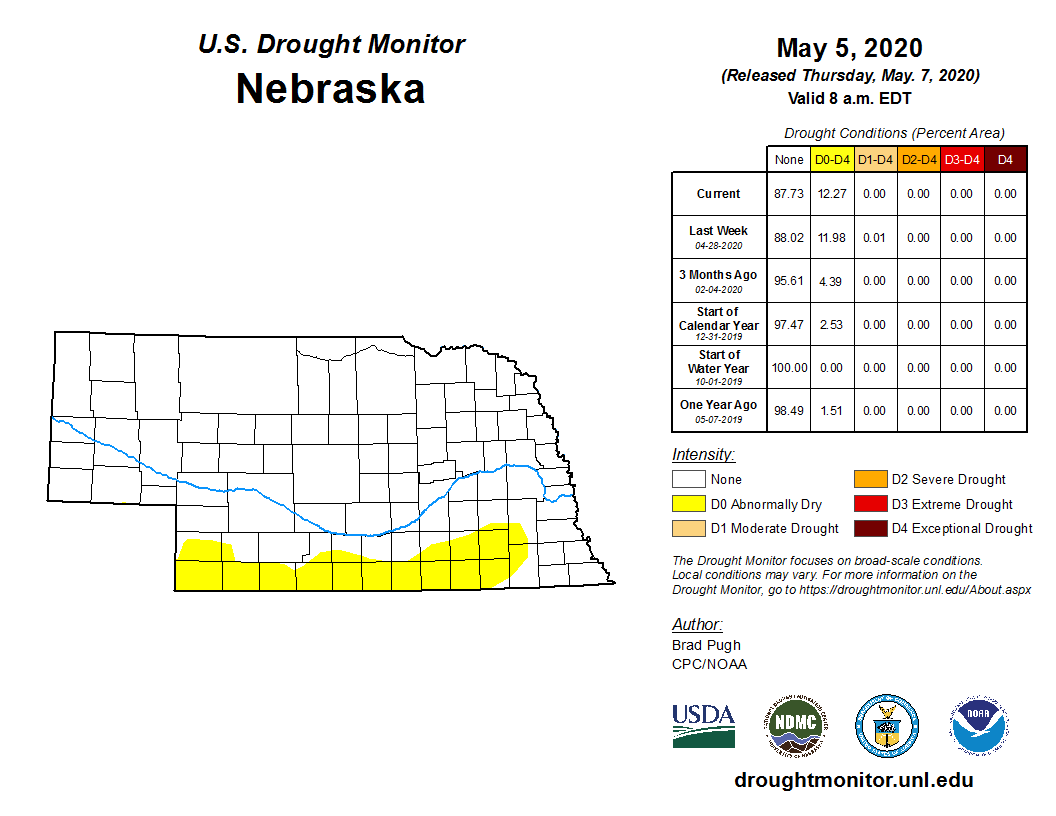
Nebraska had its sixth-driest April since modern record-keeping began (1895). The statewide monthly average of 0.71 inches was nearly an inch-and-a-quarter less than normal. The streak of dryness helped prompt U.S. Drought Monitor authors to expand abnormal dryness into a large swath of southern Nebraska counties. Temperatures ran relatively cool, particularly for nighttime lows, which averaged 30.5 degrees Fahrenheit and ranks as 12th coldest on record. Some significant snowfall amounts fell during the month but were short-lived.
Temperature
As is typical for spring, temperatures ran hot and cold this April and daily high and low temperature records were set at various locations around Nebraska. Three record high temperatures were set on April 7 (Omaha, 86 degrees; Lincoln, 87 degrees; Grand Island, 86 degrees) in an early month warm spell and then on the April 30 (Alliance, 87 degrees). In fact, the Chadron and Scottsbluff airports reached 90 degrees. Chadron also hit -10 degrees during the month – a 100-degree difference between highest and lowest temperature (Nebraska, honestly, it’s not for everyone). Elsewhere, teens and single digits were the lowest observed temperatures. Record daily low temperatures were set in mid-April at locations from Omaha to Scottsbluff. Overall, low temperatures were quite cool compared to normal (12th coldest). The monthly statewide average temperature of 45.9 degrees was 2.4 degrees below normal.
Precipitation
April was punctuated by a few snowstorms leaving short-lived fingerprints on the spring landscape. Bushnell came in with nearly a 14-inch total for the month. Relatively heavy swaths occurred in the southwest, northeast, and around the Platte River in the eastern half of the state. Omaha (5 inches on April 16), Lincoln (4 inches on April 16) and Grand Island (3.8 inches on April 17) all had record daily snowfalls.
Aside from the far southeast corner, rainfall was scant this month in Nebraska. Total precipitation (liquid plus snow water equivalent) in the southeast was about 2 inches, with Auburn coming in at 2.65 inches, the highest statewide. Elsewhere, totals were generally in the half inch to inch range, with lesser amounts in northern and far southern areas. Statewide average precipitation was sixth lowest on record (0.71 inches).
Soils, Agriculture and Impacts
April was split into three distinct periods that had major impacts on agricultural operations during the month. The month opened up warm and dry, only to see record cold, snow, high winds, and generally miserable conditions during the middle third of the month. Welcome warmth and below normal moisture the final third of the month resulted in widespread planting of summer crops.
Daily average soil temperatures from the Nebraska Mesonet reached the low 60s across southern Nebraska by April 7, with upper 40s reported across the northern quarter of the state. Significant snow and well below normal temperatures during the April 10-17 period dropped average daily soil temperatures into the low 30s north to low 40s south by April 17. Above normal temperatures the final 10 days of the month rapidly warmed soil temperatures into the acceptable corn planting range of 55 degrees or greater by April 21.
The dry conditions at the beginning of the month allowed producers to begin planting oats and start field preparation work. It was a welcome respite for cattle producers during the heart of calving season. Field activity came to a grinding halt with the outbreak of cold air and snow events, but the moisture that fell with the snow should have benefited producers in eastern and parts of southern Nebraska who were indicating that dry surface conditions were inhibiting herbicide applications. Most of this moisture missed south central and southwest Nebraska and producers were reporting that they were having to plant deeper to reach adequate moisture for germination.
The warm and drier than normal conditions the final third of the month promoted rapid planting, as precipitation events that did occur were insufficient to cause significant planting delays. The last crop report release during April from the Nebraska Agricultural Statistical Service (NASS) indicated 20% of the corn had been planted as of April 26, ahead of last year’s pace of 12% and the five-year average of 16%. Soybean planting stood at 8% completed, four times the five-year average. With the warm and dry conditions experienced the final four days of the month, it is entirely possible that over half of the corn acreage could be planted by the time NASS releases its first May planting progress statistics. The exception was across parts of central and north central Nebraska, where high water tables from excessive moisture the past three years were preventing producers from planting. If prevent planting options are taken this year in Nebraska, this area of the state will likely be epicenter of problems this spring.
Outlook
The Climate Prediction Center’s (CPC) two-week outlook for May released April 16 called for above normal temperatures along the U.S. coastal states, with equal chances of above, below, or normal temperatures for the interior. The updated May forecast has switched to favoring above normal temperatures across the western United States, including a slight chance for above normal temperatures over the southwestern third of Nebraska. Below normal temperatures were indicated for the Great Lakes and Northeastern states. For the remainder of Nebraska, there are equal chances of above normal, normal, or below normal temperatures.
The CPC precipitation outlook indicated a broad area of above normal precipitation from the northern Plains south-southeastward through the lower Mississippi River valley. The updated outlook issued at the end of April now depicts below normal precipitation for the Great Lakes region, with the southwestern flank of this region touching extreme northeastern Nebraska. Above normal precipitation is forecasted from eastern Texas northward to the extreme southeastern corner of Nebraska. This area of above normal precipitation includes most of the lower Missouri and Mississippi River valleys. Below normal precipitation is also forecasted for just west of the state with a below normal moisture indicated for portions of the central Rockies, including the southwestern half of Wyoming and the northwestern third of Colorado.
April Extremes
Nebraska’s statewide weather network operated by the Nebraska Mesonet of the Nebraska State Climate Office cataloged the following extremes this April:
Highest air temperature: 89.13°F on the 7th at Nebraska City 3NW
Lowest air temperature: -1.89°F on the 3rd at Alliance 6NW
Greatest 24-hour temperature change: -58.18°F from the 1st to the 2nd at Naper 12SW
Greatest 12-hour temperature change: 54.50°F from the 10th at Champion 5SE
Highest 4-inch bare soil temperature: 81.61°F on the 27th at Guide Rock 3E
Lowest 4-inch bare soil temperature: 27.60°F on the 3rd at Ainsworth 2NE
Highest one-day liquid precipitation event: 1.38 inches on the 25th at Rulo 5SW
Highest 5-second wind gust: 62.23 mph on the 28th at Long Pine 20S
Highest mean sea level pressure: 1042.31mb on the 3rd at Harrison 4NW
Lowest mean sea level pressure: 994.99mb on the 11th at Champion 5SE
Wind chill: -15.25°F on the 3rd at Harrison 4NW
Source: The Nebraska Mesonet at Nebraska State Climate Office
