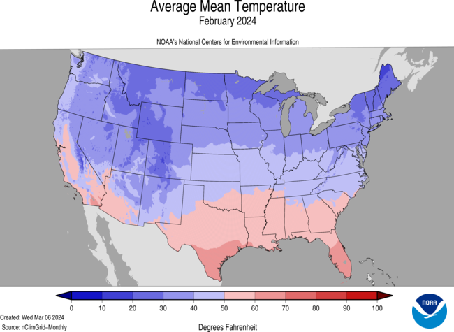
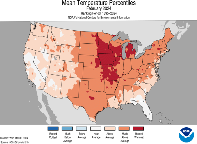
2nd warmest February on record
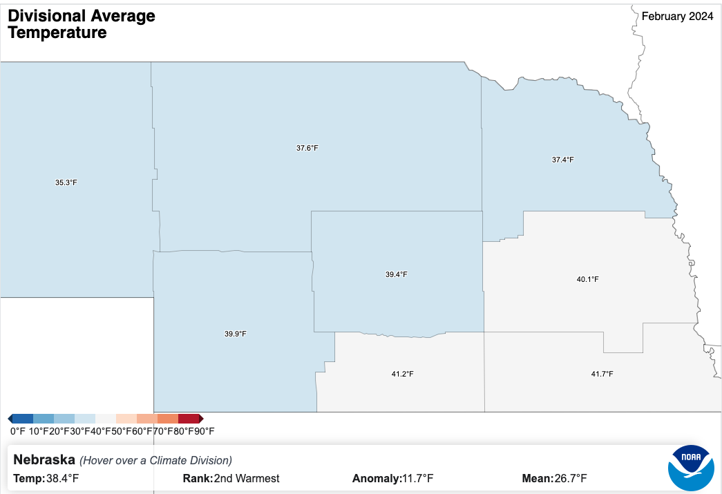
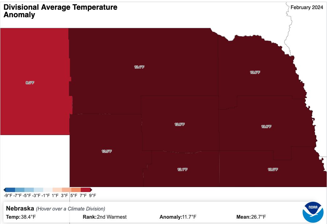
The statewide average temperature of 38.4F in February 2024 was 11.7F above average and made it the second warmest February on record in Nebraska, cooler only than February 1954 (40.2F). For the eastern crop reporting districts, it was the warmest February on record and only the Panhandle was not in the top 5 warmest. Anomalies were north of 10F for all crop reporting districts in the state except the Panhandle. Strongest warm anomalies were found in the Northeast and East Central crop reporting districts with both checking in at +13.8F
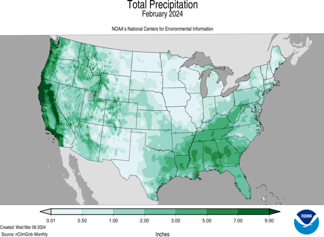
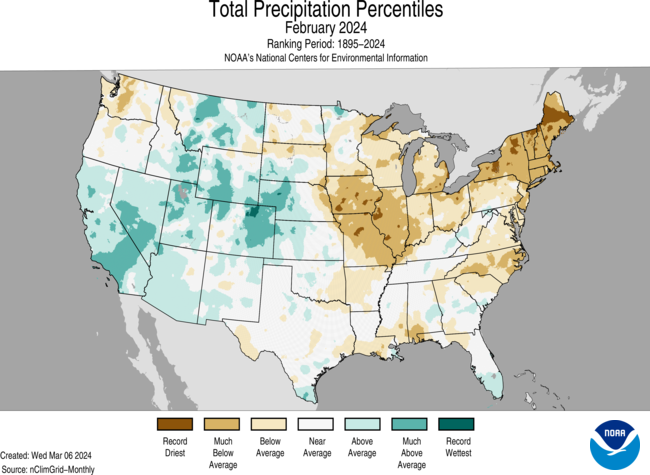
Precipitation slightly above average
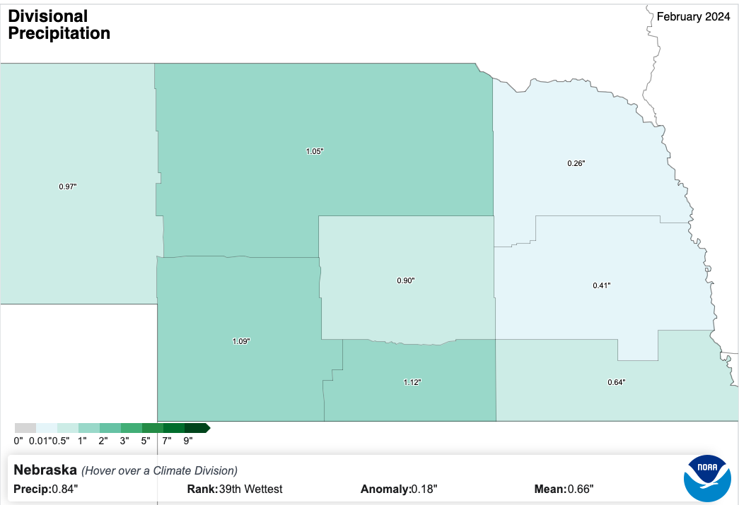
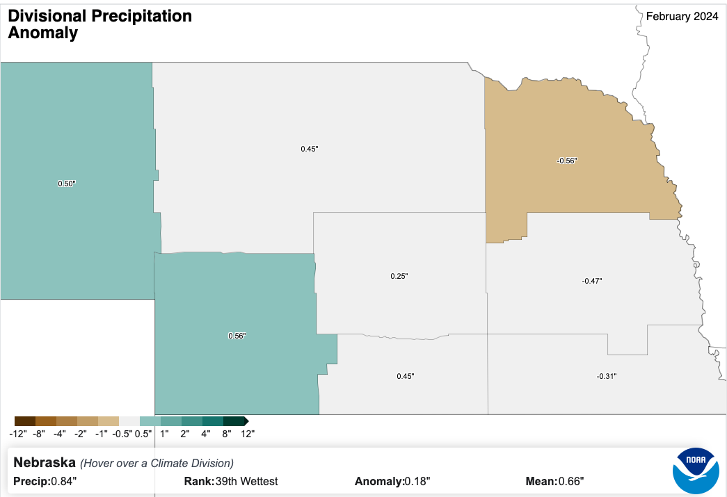
The statewide average precipitation was 0.84", 0.18" above average. For the Panhandle, the average of 0.97" was the 10th wettest on record and precipitation was also above average for the North Central, Southwest, South Central, and Central crop reporting districts. Precipitation was below average in eastern Nebraska and was particularly below average in northeast Nebraska, where it was the 18th driest February on record. Most of the precipitation that did occur in the central and eastern sections of the state fell in the first weekend, with heaviest rain totals found over the central section of the state from Broken Bow to Holdrege, where totals over an inch were common. After the first weekend in February, most of the precipitation in the state occurred in the Panhandle and North Central sections of the state. Much of this was in the form of snow, with stations/observers around Scottsbluff and Alliance reporting 12"+ of snow for the month. The moisture in the Panhandle was welcome after a dry January.
Snowfall Inequality
While sections of the Panhandle had over a foot of snow in the month of February, most locations had less than 3" and several locations along and south of I-80 in central and eastern Nebraska had no measurable snowfall all month. This set or tied record low snowfall for the month of February in those locations with no measurable snowfall.
Bruce Springsteen moves "I'm On Fire" to his Nebraska album
While the entire month was well-above average statewide, the 26th of February deserves the title of a 1980's Bruce Springsteen song as a headline. Rationale: Temperatures hit or exceeded 80 for the first time in February for much of southeastern Nebraska and were well into the 70's in central and northeastern Nebraska. The warm temperatures were also accompanied by stronger winds and very low humidity. This combined with a high fuel load in dormant vegetation meant that conditions were ripe for wildfires. Unfortunately there was a large fire in west central Nebraska in an area known as Betty's Way. Over 70,000 acres burned and took several days to fully contain. No one was injured but homes and a lot of agriculture infrastructure were destroyed in the fire.
Catch Me I'm Falling
Sticking with music from the 80's in this summary, the all-time record temperatures in eastern Nebraska were replaced by a quick blast of winter. Temperature drops between the afternoon of the 26th and 27th were over 40F statewide and approached or hit drops of 60F in northeastern Nebraska. For Norfolk, the drop from 75F to 15F between the 1556 CST observations on the 26th and 27th was a new all-time temperature drop. For Valentine, the 58F drop from 68F to 10F was good for third place. Temperature drops of 54F and 53F in Omaha and Lincoln respectively were also good for third place all-time.
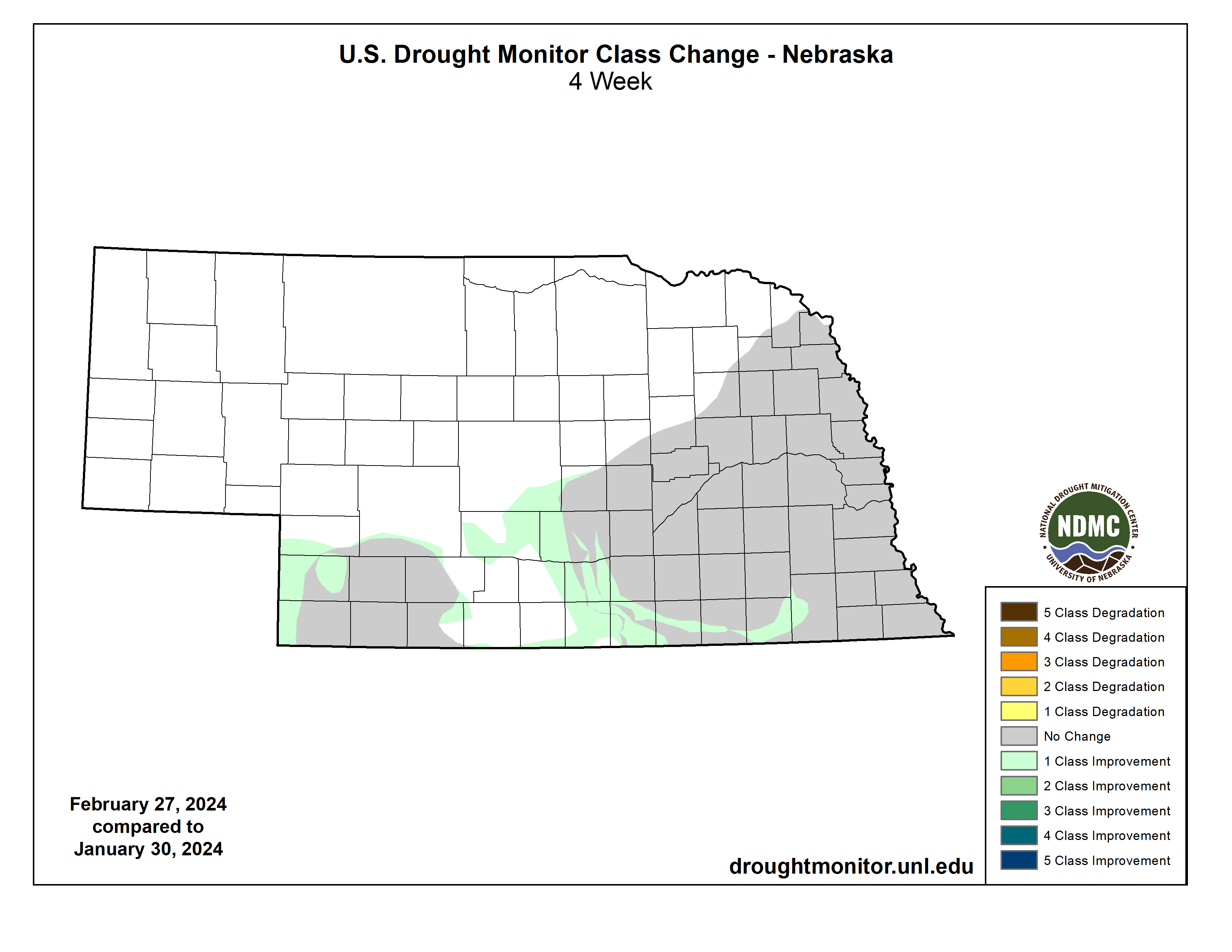
Drought Update
There was some improvement early in the month across southern portions of the state, with a slight decrease in the overall percentage of the state in drought (26 vs. 25 percent) at the end of February compared to the beginning of the month. This continues a positive trend in drought removal that began last spring.
Precipitation Summary by Crop Reporting District
Panhandle 0.97" (+0.50"), 10th wettest
North Central 1.05" (+0.45")
Northeast 0.26" (-0.56")
Central 0.90" (+0.25")
East Central 0.41" (-0.47")
Southwest 1.09" (+0.56")
South Central 1.12" (+0.45")
Southeast 0.64" (-0.31")
Temperature Summary by Crop Reporting District
Panhandle 35.3 F (+8.0 F), 6th warmest
North Central 37.6 F (+12.4 F), 2nd warmest
Northeast 37.4 F (+13.8 F), Warmest
Central 39.4 F (+12.8 F), 2nd warmest
East Central 40.1 F (+13.8 F), Warmest
Southwest 39.9 F (+10.5 F), 2nd warmest
South Central 41.2 F (+12.1 F), 3rd warmest
Southeast 41.7 F (+13.2 F), Warmest
Monthly Max/Min Snowfall, Precipitation, Temperature
Max Snowfall: BUSHNELL 15S with 14.2"
Max Precipitation: CALLAWAY 0.2 S with 2.08"
Max Temperature: FALLS CITY BRENNER FIELD with 82F
Min Temperature: AGATE 3 E with -11F
Eric Hunt, University of Nebraska Extension