Nebraska finally saw a bit of a reprieve from the incessant rainfall. While some portions of the state, primarily the southeast quarter, did receive rain totaling more than 4 inches for June, the rest of the state received anywhere from 1 to 3 inches. We began the month on the warm side and cooled down during the second and third weeks with even a few record-low temperatures reported. Conditions warmed back up to round out June with highs topping out in the triple digits at some locations around the state; southwest Nebraska recorded 105°F. The heat was a welcome trend for growers across the state as late planted crops were finally getting some necessary heat units.
Precipitation
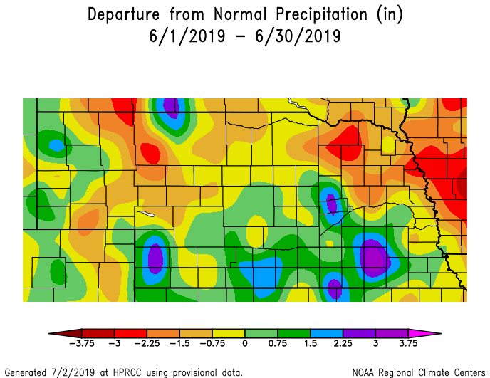
Rain was above normal for much of southern Nebraska. In the southwest some areas saw more than 4 inches and in the southeast more than 7 inches fell in isolated areas. Some 4-inch monthly totals were reported in the Sandhills but generally rainfall was in the 1.5- to 3-inch range. The statewide average rainfall for June was 3.6 inches, which is 0.09 below normal.
Anywhere from one-third to half of the days in June had measurable rainfall. Quite a few locations around the state saw at least one daily rainfall amount totaling 1 inch or more. The highest daily rain observation was 4.04 inches near the town of Max in Dundy county. Several locations reported a daily rain amount of 3 inches or more. The Nebraska Mesonet site near Guide Rock received 3.8 inches of rain in one hour on June 15 (ending at 5 p.m.). These intense, convective rain events were not uncommon during June. The nearly 4-inch rain in one hour near Guide Rock was accompanied by a 70 mph wind gust later that evening due to the passage of a storm.
The seven-day average streamflow at the end of June showed that conditions were above normal to much above normal for most areas of Nebraska, aside from the Republican River. The Missouri River at Plattsmouth and points south were above flood stage at the start of July.
Temperatures
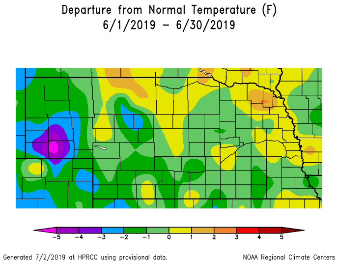
In general, temperatures started the month warm, transitioned to cool for the second and third weeks of the month, and ended warmer than normal with triple digit heat in some areas. In fact, several record low temperatures were reported during June. The Grand Island airport reported a record low high temperature of 65°F on June 23. North Platte set a new record low of 43°F on June 24 and Alliance almost got down to the freezing mark with a low of 33°F on June 10. High temperatures topped out in the mid-90s for most locations. However, scattered areas around the state did reach 100°F or warmer and a 105°F report at Culbertson, west of McCook.
Aside from northcentral and northeast Nebraska, temperatures for the month averaged on the cool side during June. The statewide average temperature of 67.9°F was 0.4 degrees cooler than normal.
One tornado was confirmed during June. It occurred on June 22 in southwest Nebraska, 10 miles north of Kimball. Hail was reported nearly every day somewhere in Nebraska during June for a total of 108 reports. June 24 was quite active with 31 hail reports on this date. High wind reports were most plentiful on June 20 with 60 reports made as a series of storms moved across the state.
Agriculture
During the first half of June, agricultural producers continued to battle cool and wet conditions, which had dominated most of the month of May and delayed or preventing crop planting.
Hot and humid conditions developed during the last 10 days of June, with daytime temperatures consistently in the 95°F to 103°F range, while overnight lows dropped only into the low to middle 70s. Corn responded with rapid growth, but remained behind normal when compared to crop growth stages.
Extension educators indicated corn planted late in the season was showing signs of stress, or leaf rolling, likely because the plant’s root base wasn’t developed enough to handle the late June heat. They said if July started to warm and dry, early planted crops would likely stress as well heading into the pollination season.
Pasture growth, on the other hand, was phenomenal over the spring though hay harvest was still delayed due to excessive moisture.
Wet spring conditions also led to an explosion of the Thistle caterpillar (painted lady butterflies) across the state. Soybean defoliation was reported statewide, but entomologists said few fields met the 30% defoliation threshold recommended for insecticide treatment yet.
Drought
It is no surprise that Nebraska remains without any drought or abnormal dryness. Our neighboring states are similarly blank on the U.S. Drought Monitor map. The only areas of concern in the Plains is a swath of abnormal dryness in northern North Dakota and Minnesota, with a pocket of D1 and D2 in northcentral North Dakota.
Outlook
The climate outlooks issued at the end of June from the Climate Prediction Center indicate a continuation of the general trend toward cooler- and wetter-than-normal conditions for July in Nebraska. Cooler-than-normal temperatures are favored for the central plains, portions of the Midwest and extending up through the great lakes region. A large portion of the central U.S. lies in an increased probability of wetter-than-normal conditions. It is important to note that this outlook is for the general tendency and does not indicate the magnitude. Going forward into the July through September timeframe, the pattern of cooler and wetter than normal continues.
Extremes
Nebraska’s statewide weather network operated by the Nebraska Mesonet at the University of Nebraska-Lincoln cataloged the following extremes this June:Highest air temperature: 102°F on June 29 at Brule 6SW
Lowest air temperature: 32°F on June 10 at Arthur 8S
Highest 4-inch bare soil temperature: 100°F on June 30 at Emmet 2E
Lowest 4-inch bare soil temperature: 51 on June 24 at Dickens 9N
Highest 5-second wind gust: 70 mph on June 15 at Guide Rock 3E
Highest 1-day rain event: 3.9 inches on June 15 at Guide Rock 3E
Source: The Nebraska Mesonet at Nebraska State Climate Office, University of Nebraska-Lincoln


