Highlights
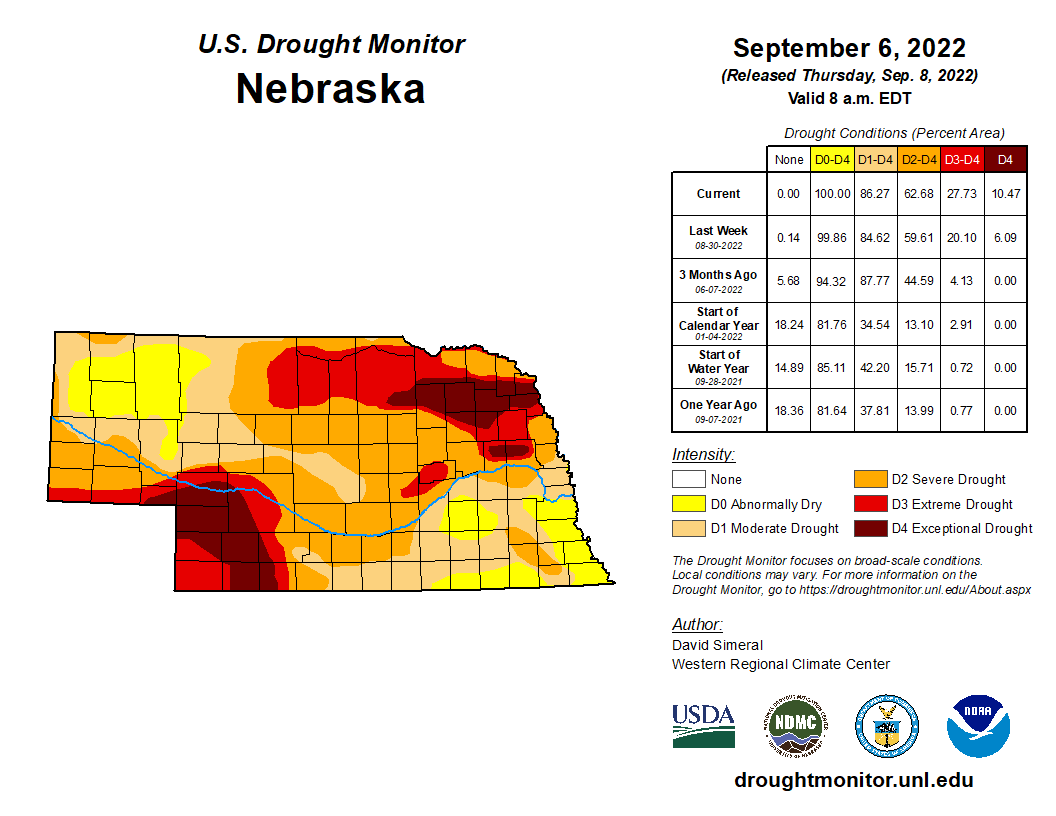
Nebraska experienced the second driest August on record (0.94 inches), just two years after the driest August on record in 2020 and a mere three years since the wettest on record (5.14 inches in 2019). We were on the warm side of normal for the month. Incidentally, warmer and drier than normal conditions were predicted. Drought conditions degraded for much of the state and we start fall with all of Nebraska at least abnormally dry and 86% in drought. The most recent crop condition report from the National Agricultural Statistics Service has 78% of pasture and range conditions in the poor to very poor categories. Subsoil moisture supplies show 80% of Nebraska in the very short to short category illustrating the extent of dryness. The official September outlook has all of Nebraska in the warmer than normal probability category and much of the state also with a probability of drier than normal conditions. As such, drought conditions would be expected to worsen overall, higher than normal fire danger on high wind days and continued water level declines.
Precipitation and Drought
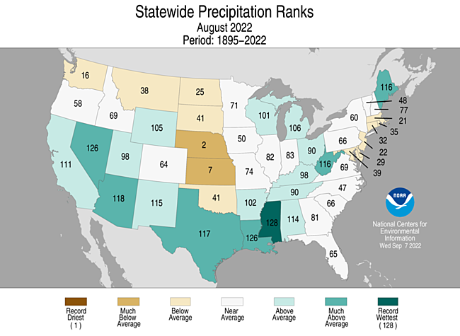
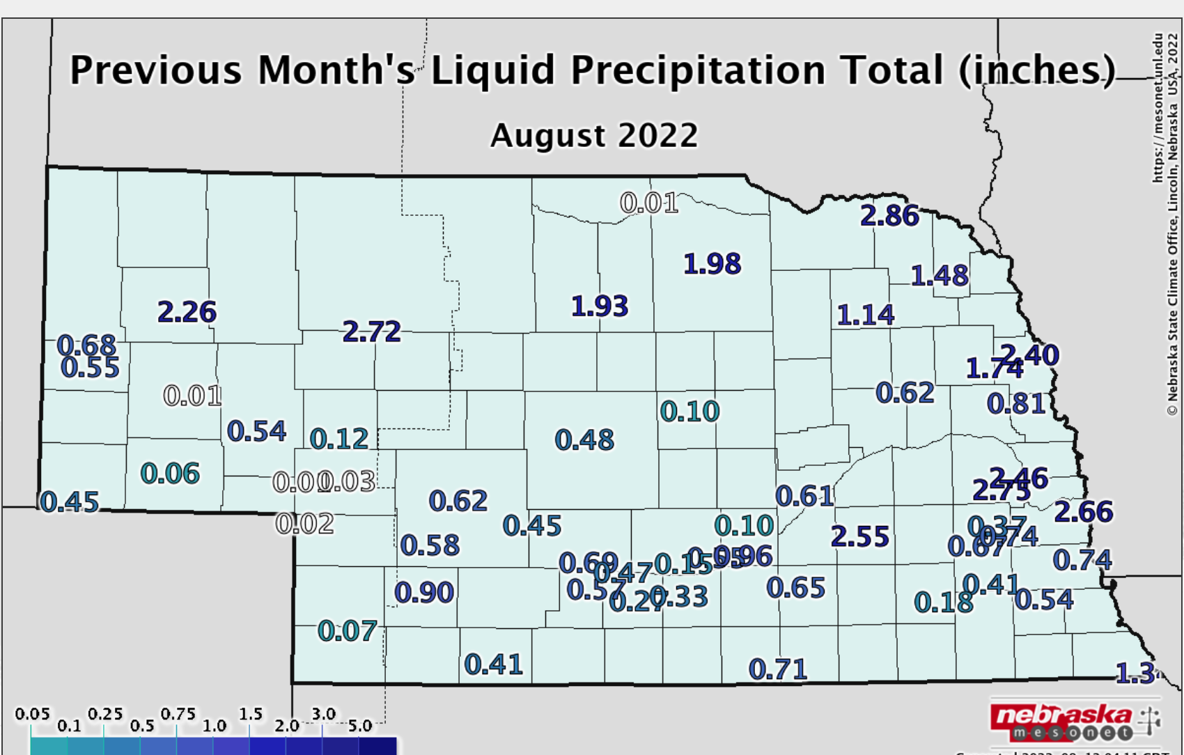
The statewide average precipitation of 0.94 inches ranks as second driest on record, eclipsed only by 2020 when 0.92 inches were reported. This monthly total is 1.92 inches below average and caps off our third driest summer on record (5.80 inches for the statewide average). The climate trend of the past three decades is an overall drying by about 1.25 inches for summer precipitation. A few isolated areas of relative wetness occurred around the state. The southern Omaha metro area reported around four inches of rain during August with Papillion observing 4.92 for the month. Areas in the northeast such as Crofton, Hartington reported near 3.5 inches. A pocket of relatively heavy rain was observed in a narrow band from Agate through Gordon with 2 – 4 inches. An area from York to about Milford also reported 2 – 4 inches. The remainder of Nebraska received less than two inches.
Drought conditions worsened for much of the state with on to two class degradations, according to the U.S. Drought Monitor. Improvements were seen in the areas mentioned above that received appreciable moisture. The most recent depiction of the Drought Monitor shows 86% of Nebraska in moderate or worse drought and 14% abnormally dry. Exceptional drought (D4) is found in the northeast and southwest and covering an area of about 10.5%. These areas are running precipitation deficits greater than 10 inches for their year to date totals (50% of normal or less).
Temperature
It was the 20th warmest August in Nebraska this year with an average statewide temperature of 74.9°F, which is 2.6°F above normal. Many observing locations reached triple digits during the month with a high of 111°F on the 3rd near Springview in north central Nebraska. The Nebraska Mesonet station north of Fordyce observed a heat index temperature of 116°F on August 2nd. High temperatures at or above 100°F occurred on 5 or greater days for about a dozen locations around the state – Chadron area, Verdel and Springview, and a swath in southwest Nebraska. The lowest statewide temperature was 39°F reported near Agate on the 31st. In our climate history, temperatures have not experienced a strong warming or cooling trend during August here in Nebraska.
Severe weather reports were occurred on seven days during the month with zero tornados, 32 hail and 7 high wind reports. The Nebraska Mesonet station near Hayes Center reported a 55 mph wind gust on the 1st of August.
Outlook
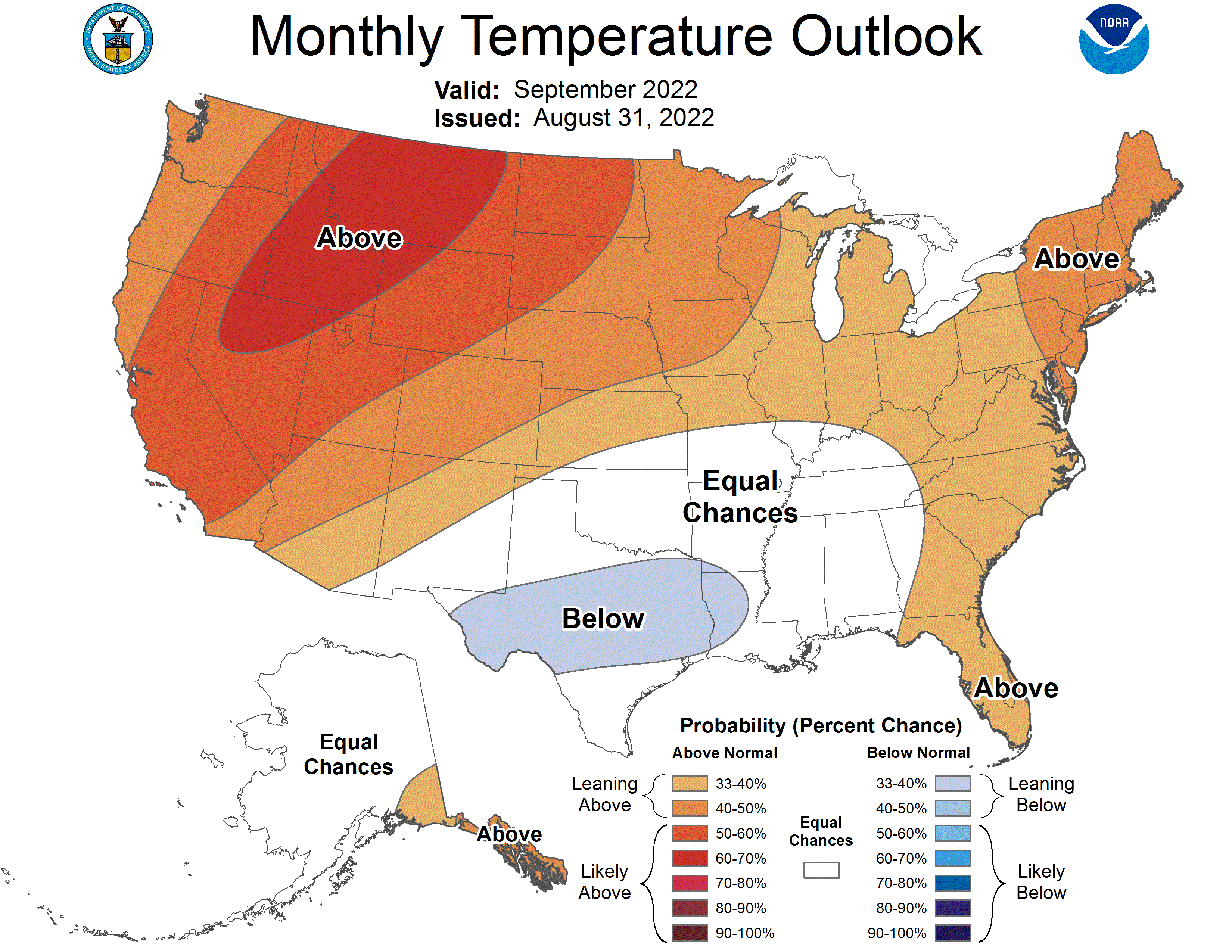
The Climate Prediction Center (CPC) issued their official August temperature and precipitation outlooks for the United States on August 31st. The September temperature outlook for Nebraska is tilted toward above normal temperatures. The northwestern Panhandle has been assigned a 60-70 percent probability of receiving above normal temperatures, while the southeastern corner has been assigned a 33-40 percent chance for the same condition. The remainder of the state has been assigned probability odds of 50-60% for above normal temperatures. The probability for below normal temperatures are 7 percent or less for the northwest Panhandle, 17-27% for the southeast corner of the state and 7-17% for the remainder of Nebraska.
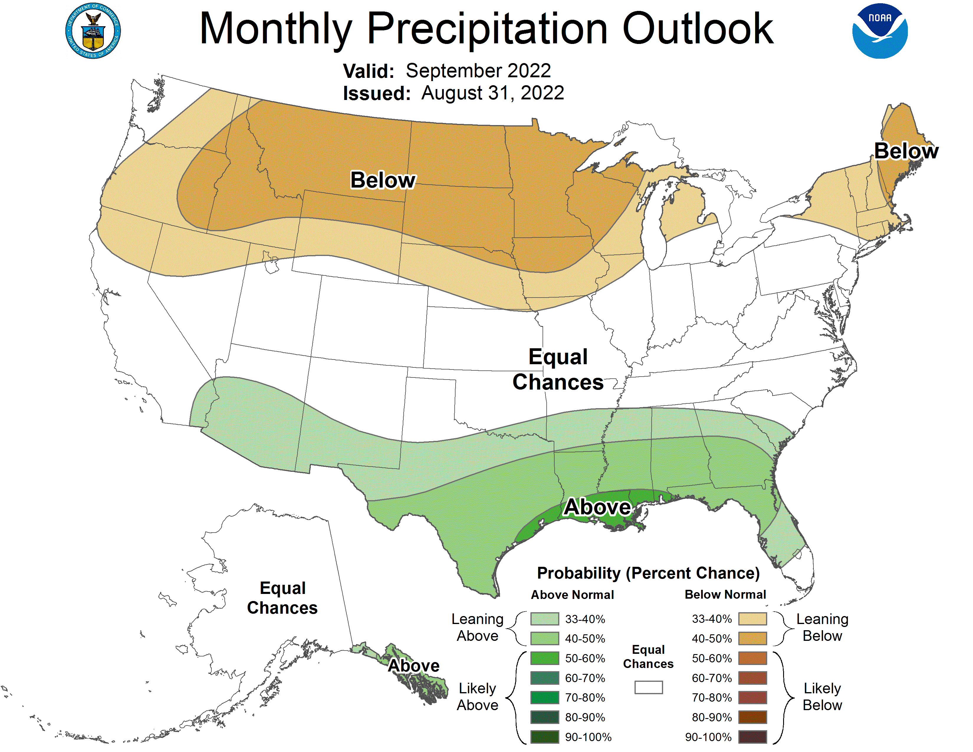
Nebraska’s September precipitation outlook is tilted to drier than normal conditions for most of the state. CPC has assigned equal chances of above normal, normal or below normal precipitation for the southwestern corner of the Panhandle and the western half of the southwestern corner of the state. The highest probability of below normal moisture has been assigned to Niobrara River valley where the probability of below normal precipitation is between 40 and 50 percent. The remainder of the state has a slight tendency for below normal moisture with a 33-40% chance of occurrence. The probability for normal moisture across Nebraska is 33%, while the odds for above normal moisture is 33% for the southwest corner and southwestern Panhandle, 17-27% for the Niobrara River valley and 27-33% for the remainder of the state.
Agricultural Update
The heat and dryness from July dominated August across Nebraska. The lack of widespread moisture led to significant crop rating declines according to the Nebraska Agricultural Statistics Service (NASS). Although not perfect, crop ratings at the end of August can offer a glimpse into the production potential of agricultural crops grown across the state. The good and excellent crop rating percentages combined offer a glimpse of how widespread the best-looking crops are across the state. The latest good to excellent crop condition ratings through August 28th as reported by NASS show corn at 39%, soybeans at 43%, sorghum at 20% and pastures at 7%. The last July crop report of conditions through the 31st had corn at 54% good to excellent, 59% for soybeans, 36% for sorghum and 13% for pastures.
Extension Educators have reported that some corn fields were harvested the final week of August in parts of central Nebraska because widespread heat and the lack of moisture caused fields to mature several weeks earlier than normal. Production fields that have already completed insurance claims are being cut for silage/earlage (corn), baled for hay (soybeans) or baled for stalks (corn). Ranchers are hoping for widespread fall rains to promote fall green up to help extend limited feed supplies this coming winter season. Topsoil moisture is very short or completely lacking across the southern half of the Panhandle and the southwest corner of the state. Wheat planting usually begins during September and there is concern that there will not be enough moisture to seed the crop and/or establish a healthy stand prior to the winter dormancy period.
August Mesonet Extremes:
Highest air temperature: Naper 12SW , 107°F, 2ndLowest air temperature: Whitman 5NE , 41°F, 30th
Highest heat index temperature: Fordyce 4N , 116°F, 2nd
Max wind gust (9ft): Hayes Center 3N , 55 mph, 1st
Highest daily precipitation: Fordyce 4N, 2.29 inches, 16th
Highest 4inch soil temperature: Dickens 1NE, 107°F, 13th
Lowest 4inch soil temperature: Lincoln 1500 N 45th , 62°F, 17th
Source: The Nebraska Mesonet at Nebraska State Climate Office