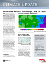
Cooler-than-normal weather prevailed across much of the country this November. The strongest temperature departures occurred in a swath east of Nebraska, covering the midsection of the U.S. Nebraska averaged from 5° to 8°F below normal for the eastern third of the state and about 3 degrees below normal in the central and west. Some record low temperatures were observed during the second week of the month. Omaha (14°F), Lincoln (11°F), Norfolk (4°F), and Grand Island (7°F) airports each set or tied records on Nov. 9. The lowest observed temperatures for the month were in the single digits statewide, with the lowest at Bridgeport (-9°F) and the Nebraska Mesonet station in Scottsbluff (-9°F).
The month was not without warm weather, however. The highest temperatures this November in Nebraska occurred around Thanksgiving with a few locations reporting temperatures of 70°F or higher. In fact, Valentine reported a new record high of 74°F on Nov. 22.
The monthly average temperature was 33.1°F, which is 3.6°F cooler than normal and ranks as 26th coldest (out of 124). Looking at year-to-date temperatures, all but a handful of locations around Nebraska are trending anywhere from 0.5 to 2.5°F cooler than normal. Incidentally, temperatures have been progressively increasing in Nebraska during November (a warming of 2.4°F since 1895). Five of the top 10 warmest Novembers have occurred in the past 20 years.
Soils are seasonally cooling, and by the start of December, the weekly average bare soil temperature was in the mid-30s. Daily average values can be tracked on our Mesonet site.
Precipitation
Conditions were dry, compared to normal, in eastern Nebraska (around 75 percent of normal) and relatively wet (150 percent of normal) in the west. Precipitation totals ranged from 0.3 to 1.3 inches around the state. The statewide monthly total precipitation was 0.83 inches, a few tenths of an inch below normal.
Snow was plentiful at some locations during November with several swaths of 10 inches or more for the monthly total. Thanks in large part to a Thanksgiving weekend blizzard impacting southeast Nebraska, Tecumseh reported 16 inches for November and an area from Fairbury, Beatrice, Auburn and Nebraska City reported a foot. Incidentally, the Nebraska Mesonet weather station near Guide Rock reported a wind gust of 51 mph during this event. The Holdrege, Minden area reported 10 inches for November, an area in the southwest also received 10 inches and a foot was reported in portions of the Panhandle. The snowfall totals are off to a jumpstart this year with portions of southcentral and southeast Nebraska already received half or greater of their average total for the entire season.
There were a few daily precipitation records during November. A daily snowfall of 3.6 inches was a new record for Nov. 8 at the Grand Island Airport observing station. Also during November was a daily record precipitation – 0.33 inches at the North Platte Airport on Nov. 25.
Drought
Continuing a three-month trend, there were no changes in drought classification for November, according to the U.S. Drought Monitor. Most areas of the country experienced improvements in drought conditions. Exceptions were for portions of Florida, Oklahoma, Wyoming, California, Nevada and Washington that saw dryness concerns worsen.
For year-to-date precipitation, most of Nebraska is in a surplus condition. Soil moisture observations taken at Nebraska Mesonet locations indicate the same with some areas close to saturation. A few areas around the state remain in a long-term precipitation deficit, including areas in the southeast, southwest, and Panhandle.
Agriculture
Concerns remain in the western third of Nebraska where the 30- to 90-day precipitation has shown a dry trend. The worst of the dryness is across the southern Panhandle, an area that will be watched for potential degradation during the upcoming winter season. Wet soils are limiting combine activity, but overall, harvest was wrapped up for more than 95 percent of producers. Soybeans left in the field still have moisture content between 15 percent to 25 percent, which is high enough producers face significant drying costs to offset moisture dockage from elevators.
Snow impact reports to agriculture have been limited, but feedlots have been battling muddy conditions the past four to eight weeks (location dependent). This trend will continue if large temperature swings continue and will bear watching when spring precipitation events return with surplus topsoil moisture across eastern portions of the state. Feed costs haven’t been excessive considering the amount of snow that has fallen so far this season.
Outlook
An El Nino watch remains in effect. Oceanic conditions indicate a warming in the equatorial Pacific, however atmospheric conditions are yet to be fully realized. The winter outlooks from the Climate Prediction Center are indicative of an El Nino pattern across the U.S. An increased chance for wetter-than-normal weather across the southern U.S., extending into Colorado and just reaching into the southern Panhandle of Nebraska. Temperature outlook has the odds tilted for a warmer-than-normal winter. This is predicted to be a weak event, however, and other atmospheric patterns could override the “typical” El Nino signature.
November Extremes
Nebraska's statewide weather network operated by the Nebraska Mesonet cataloged the following extremes this November:
Highest air temperature: 70°F on November 22 at Sparks 5NE
Lowest air temperature: -9°F on November 18 at Scottsbluff 2NW
Highest precipitation: 0.59 inches on November 4 at Oakland 4W
Highest wind gust: 51 mph on November 25 at Guide Rock 3E
Highest soil temperature: 61°F on November 1 at Central City 3W
Lowest soil temperature: 24°F on November 13 at Ainsworth 2NE
