
Highlights
Precipitation continued the trend of a general lack of moisture during the first month of fall. Our monthly statewide total came in at 27th driest and makes for the 12th driest three-month (July – September) period on record. At the start of October, nearly all of Nebraska is in a drought category, according to the US Drought Monitor. Portions of the northeast and southwest are in exceptional drought (D4). Temperatures averaged above normal for September and quite a few new daily high temperature records were set, most in the triple digits. The October outlook doesn’t appear to have much relief in sight with a higher than average probability of the warmth and dryness to continue. Given the dryness, fire danger will be high particularly on windy days.
Precipitation and Drought
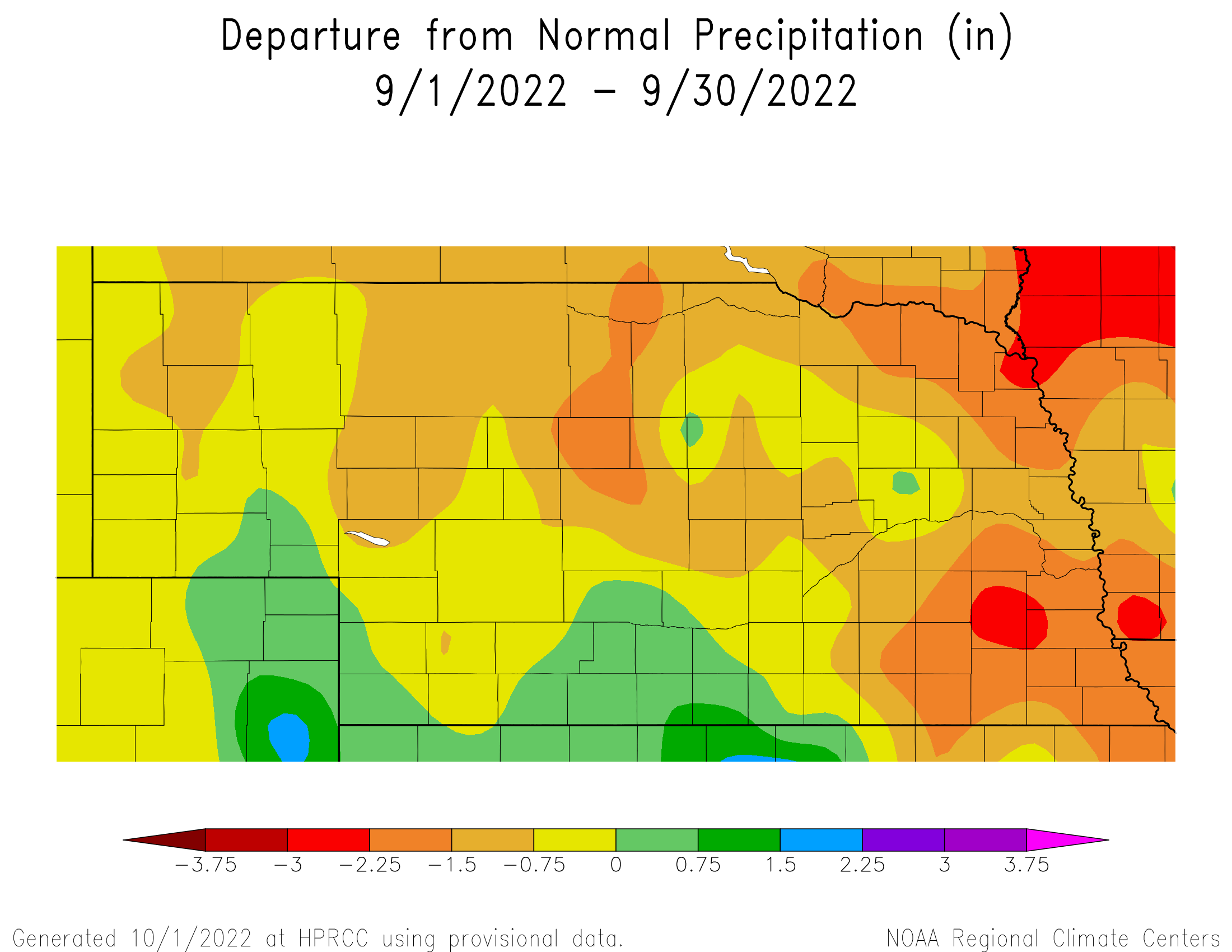
The average statewide precipitation totaled 1.27 inches, which is 0.84 less than normal and ranks in the driest 25% of all September precipitation totals going back to 1895. The highest totals were reported in southcentral Nebraska and portions of the northeast with more than two inches for the month. Dry pockets were found in much of the west at an inch or less, which is half or less of normal. There was a daily precipitation record set at Norfolk of 0.79 inch on the 17th. After the third driest summer on record, sixth driest year-to-date (Jan – Sep), and long-term dryness plaguing portions of the state, drought conditions generally worsened after another dry month. According to the U.S. Drought Monitor, 98% of Nebraska is currently in drought. Extreme and exception drought covers a combined 32%, primarily in the northeast and southwest. In these areas, precipitation over the past three years is half to 70% of normal with 36 month deficits in the 16 – 20 inch range. Soil moisture reserves here are low and without appreciable precipitation over the winter and spring, the next growing season will begin quite dry.
Temperature
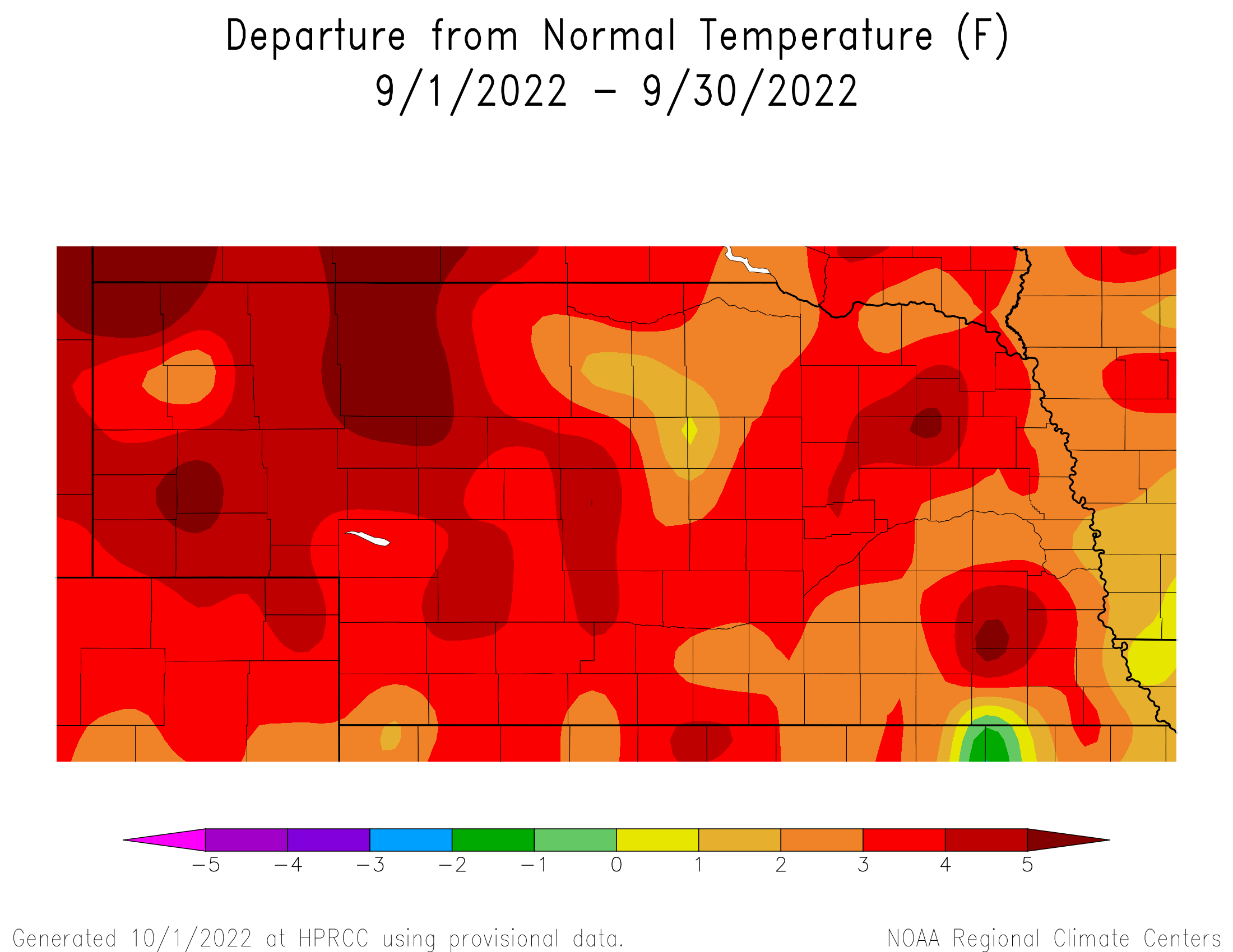
Many locations had triple digit heat during September and several records were broken. The highest statewide temperatures were above 105°F. There were five days at or above 100°F for Curtis, Scottsbluff, Chadron and Valentine, and above 95°F for five or more days for much of western Nebraska. A few scattered below freezing temperatures were observed at high elevations of the western panhandle, elsewhere the lowest temperatures were in the 30s and low 40s. The average monthly temperature of 67.4°F was 3.6°F warmer than normal. September temperatures have been trending warmer over time, gaining nearly 4°F since 1991.
Outlook
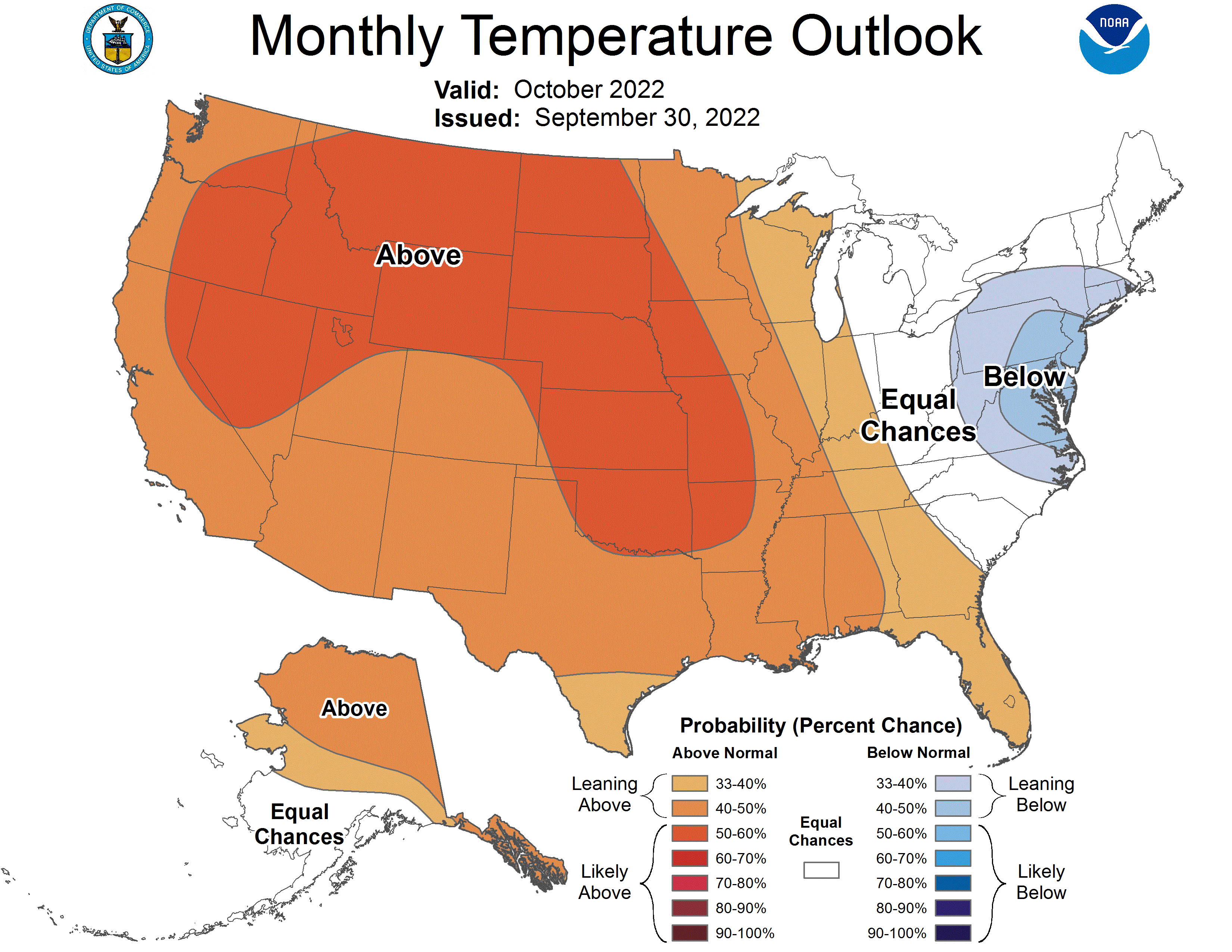
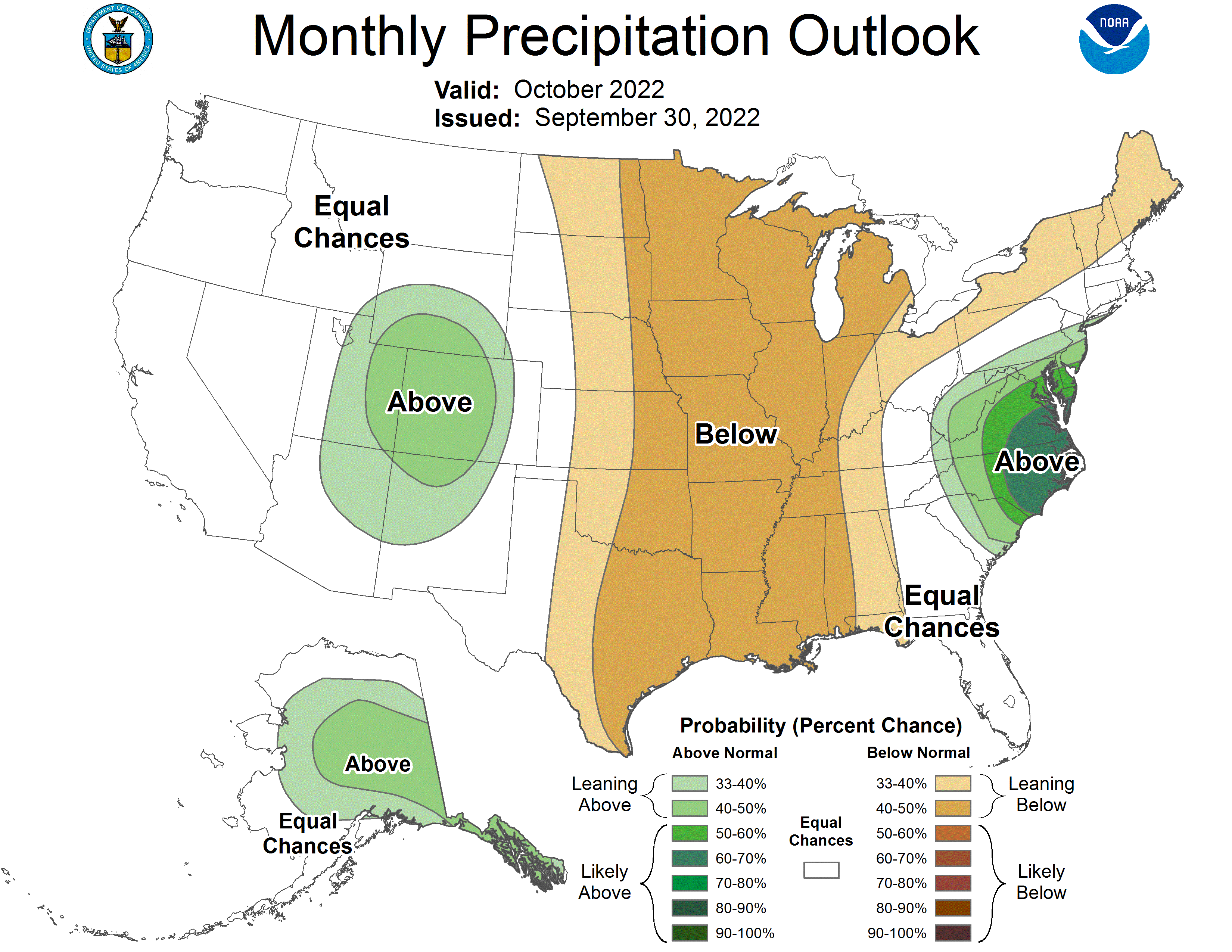
The preliminary October temperature and precipitation outlook issued September 17th indicates that above normal temperature are expected statewide, while the eastern 2/3 of the state is projected to receive below normal moisture during the month. October marks the official start to the offseason soil moisture building period that last until the end of April. If the current preliminary forecast verifies, soil moisture reserves would begin the 2023 crop production season below normal. The CPC national temperature forecast indicates above normal temperature are likely across the northern Great Basin, northern Rockies, and the High Plains region from North Dakota southward through Oklahoma. There is a slight to moderate risk of above normal temperatures for the western 2/3 of the United States surrounding the highest risk areas. The CPC national precipitation forecast indicates a moderate risk for below normal temperatures for an area from eastern North Dakota southward through the eastern half of Texas on the western periphery and from Michigan southward through the western half of Alabama on the eastern periphery. On a positive note, Colorado is directly underneath a predicted area of above normal precipitation, which includes the headwater region of the Platte River system that has been drawn down the past three years due to ongoing drought issues and high irrigation demand.
Agricultural Update
There was some limited relief to the persistent dry conditions that have encompassed Nebraska this growing season across parts of southwest, south central and central Nebraska. NERain observations indicated that the southern tier of counties from McCook to Red Cloud received 1.50-2.50 inches of moisture for the month. Monthly totals of 2.50 – 4.00 inches were reported in pockets of central and south central Nebraska. Unfortunately, a large portion of the east central Nebraska failed to receive an inch of moisture for the month of September. The state corn, soybean and sorghum crop all reached at least 85% maturity by the end of the month. Harvest activity was just beginning to ramp up by month’s end and preliminary dryland yields are below last year and trend adjusted expectations. This comes as no surprise considering the lack of moisture since the middle of July, coupled with average temperature running 4 to 6°F above normal across the western half of the state and 2 to 4°F across the eastern half of Nebraska. The first freezing temperatures of the fall were reported in the Alliance area the morning of the 12th when the Airport reached 31°F. Scattered light frost was reported across the Panhandle and north central Nebraska September 25th to 26th when air temperatures dropped into the low 30’s. There may have been some scattered light frost across northeast Nebraska the morning of the 28th with the Wayne airport reporting a low of 33°F. Preliminary data suggest that hard freeze conditions (low temperature equal to or less than 28°F) was observed at the Whitman 5NE Nebraska Mesonet station on the 26th.
September Mesonet Extremes:
Highest air temperature: Big Springs 8NE, 106°F, 8thLowest air temperature: Whitman 5NE , 28°F, 26th
Highest heat index temperature: Cook 4SW, 105°F, 20th
Max wind gust (9ft): Bushnell 12SE, 45 mph, 9th
Highest daily precipitation: Decatur 7S, 1.63 inches, 18th
Highest 4inch soil temperature: Dickens 1NE, 99°F, 6th
Source: The Nebraska Mesonet at Nebraska State Climate Office