


BLUF
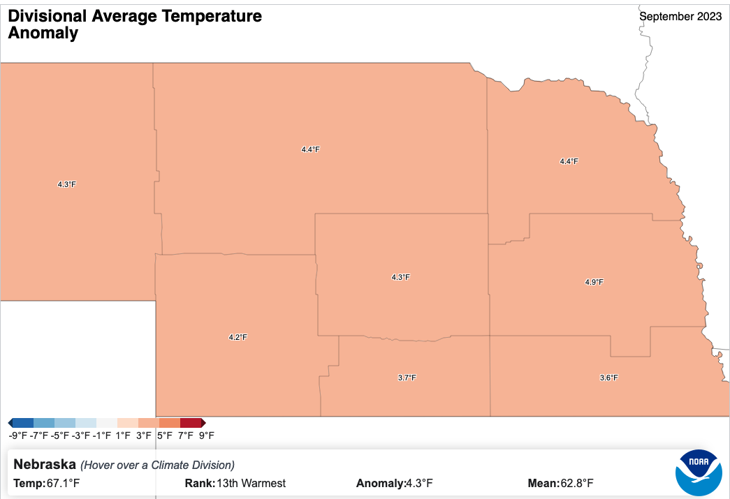
The average temperature for September 2023 in Nebraska was 67.1F, 4.3F above the 20th century average and the 13th warmest September on record. Precipitation averaged 2.19" statewide, 0.04" above average and the 54th wettest on record.
Summary
The calendar may have said it was September for 30 days but for significant chunks of the month the weather seemed closer to August than it did a traditional September. Hence the headline "August Lite". But we were not special in being warm! The entire globe was well above average. In fact it appears it was the warmest September on record by a country mile. On a happier note- Mother Nature was generous during the week of Husker Harvest Days as all three days in Grand Island featured high temperatures in the 70s and cool mornings. Ok so there was a bit of a breeze at times but come on it's central Nebraska; we would be perplexed if the wind wasn't blowing at least one of the days!
September 2023 featured some commonalities across the state and some big differences. Let's start with where we had consensus. Temperatures were well above the 20th century average statewide with all crop reporting districts (or climate divisions) being at least 3.5F above average. Most were more than 4.0F above average and the East Central district had a top 10 warmest September. All other districts came in the top 20 warmest except the Southeast, which came in at 21st warmest. Anomalies were a bit stronger on maximum temperatures than on minimum temperatures. This is mostly a reflection of the upper level ridging that was prominent throughout the month but also the dry landscape that allowed for daytime temperatures to "overachieve" more than they would have with a wetter landscape. While the whole month outside the period around Husker Harvest Days was generally warm, it was the bookends of the month that really drove the anomalies to be 3.5-5.0F above average.
In the first spell, which occurred over Labor Day weekend, temperatures exceeded 90 statewide and topped 100-102 in a few spots near the Kansas border and at a few spots in northeast Nebraska. This was generally just shy of record heat but it was likely the last straw for struggling rainfed crops and contributed to a worsening of existing drought conditions in parts of central and eastern Nebraska. The last stretch of heat occurred over the month's final days and was most pronounced in the eastern 2/3 of the state, where the air mass was warmest and where mixing was best. Western Nebraska was west of the warmest "nose" and had less wind but still had seasonally warm conditions. While temperatures were a bit lower than at the beginning of the month, the anomalies were even more impressive and several record high maximum and record high minimum records were set. Record high maximums were set on the 29th in Grand Island (95), Lincoln (96), Norfolk(95), and Omaha (95) and on the 30th in Lincoln (96) and Omaha (94). Record high minimums were set on the 29th in Grand Island (70), Hastings (68), Norfolk (64), and Omaha (68) and on the 30th in Hastings (67) and Omaha (74). Note that in Lincoln maximum temperatures at the two Mesonet sites were under the airport temperatures but were warmer for minimum temperatures.
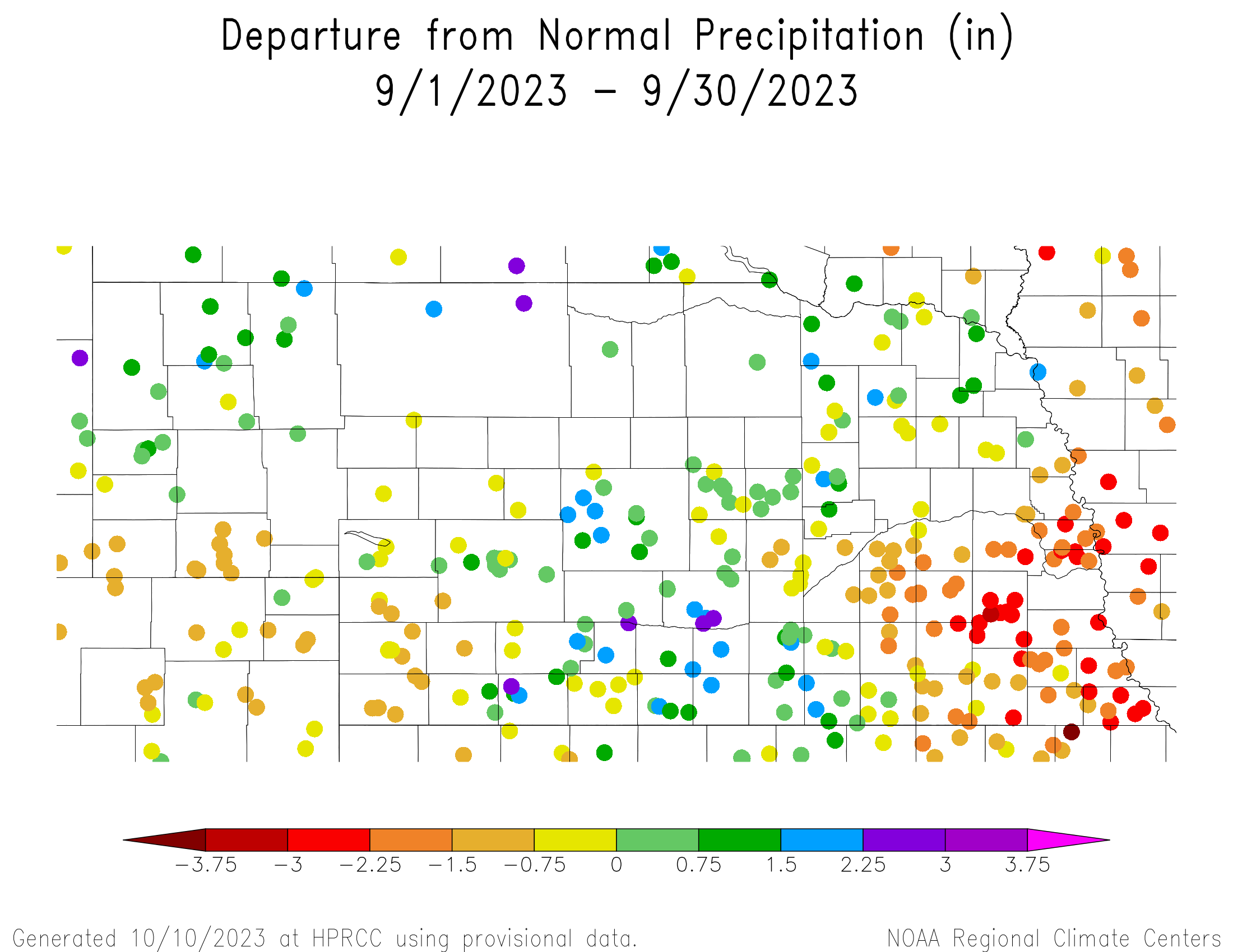
Now let's focus on where there were differences: precipitation. While the spread between amounts was significantly less than in May, some parts of the state had a wetter than average September and some places were considerably drier than average. The places that were drier than average were confined to the far southwest and to portions of east central and far southeast Nebraska where total amounts for the month were mostly under an inch. The rest of the state was around or above average for the month. The difference between the haves and have-nots wasn't necessarily frequency of precipitation so much as the amounts that fell when it did rain. In other words, there were one or two big rainfall events in much of north central, northeastern, and south central Nebraska that brought the monthly totals above long-term averages. Conversely, when it did rain in the drier areas, the amounts tended to be a quarter inch at best.
Precipitation was infrequent the first week of the month with only the western Panhandle picking up over a quarter of an inch. In the second week of the month, a storm system traversed the state that brought rain to almost everyone but it was most substantial in the southwestern and central sections of the state. Heaviest amounts fell over Custer County on the 10th. The third week brought significant precipitation to most of south central and northeast Nebraska with many places picking up over 1.5" and some locations picking up over 3" from separate storm clusters. The same mesoscale complex that soaked south central Nebraska early on the morning of the 22nd affected the southeastern quadrant of the state too but it had weakened considerably by the time it arrived and thus amounts were generally under half an inch in east central and southeastern Nebraska. In parts of northeast Nebraska, this was the first time in several weeks that significant rainfall had occurred. The last week of the month was dry, with only a few places in the far northeast part of the state receiving more than a tenth of an inch of moisture.
Drought Monitor changes
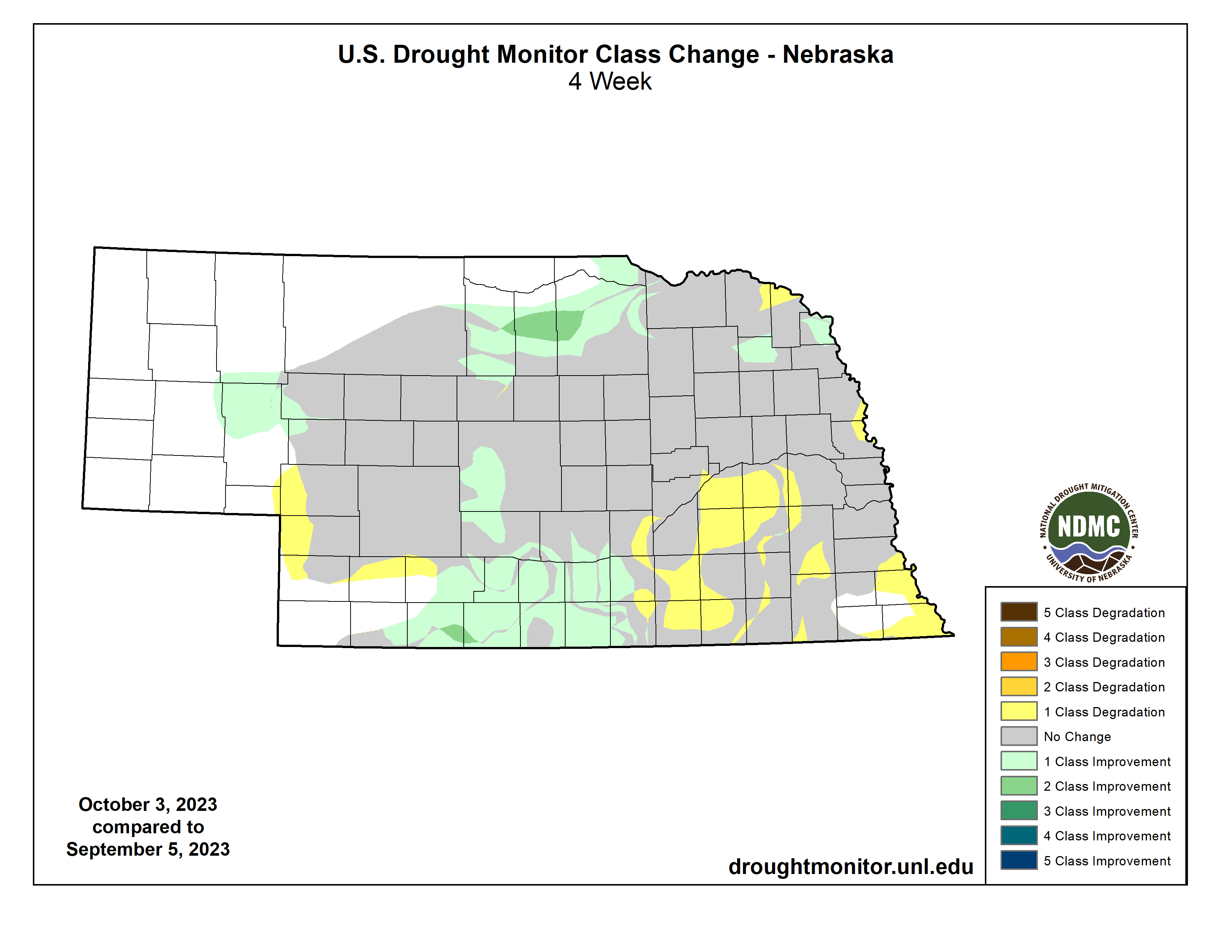
The places that did receive 2+" of rain saw improvement on the Drought Monitor in the last week of September. Areas that were driest saw degradation. This includes the western parts of Keith and Perkins counties, which has generally have missed out on the bounty that Mother Nature provided most of the rest of western Nebraska this summer. It also includes some of the hardest hit areas of central and eastern Nebraska (York, Clay, Polk, Butler, Nuckolls, Seward, and Thayer counties) and the far southeast around Falls City, which had its driest Septembers on record.Precipitation Summary by Crop Reporting District
Panhandle 1.84" (+0.42")
North Central 2.73" (+0.90")
Northeast 2.74" (-0.42")
Central 2.61" (+0.38")
East Central 1.47" (-1.55")
Southwest 1.43" (-0.24")
South Central 2.85" (+0.58")
Southeast 1.82" (-1.54")
Temperature Summary by Crop Reporting District
Panhandle 64.2 F (+4.3 F)
North Central 66.1 F (+4.4 F)
Northeast 67.5 F (+4.4 F)
Central 67.6 F (+4.3 F)
East Central 69.7 F (+4.9 F)
Southwest 68.0 F (+4.2 F)
South Central 68.9 F (+3.7 F)
Southeast 69.7 F (+3.6 F)
CoCoRaHS Extremes
Maximum and minimum precipitation in the state in September 2023 as reported CoCoRaHS observers. Note that only observers with 100% data completeness for the month were considered.
Maximum precipitation: 4.10" at red019 in Red Willow County
Minimum precipitation: 0.17" at chas036 in Chase County
Eric Hunt, University of Nebraska Extension and Nebraska State Climate Office