General Observations
This past week was a classic example of the haves and have nots. Severe thunderstorm activity occurred every day somewhere in the state this past week (7/7-7/13), except on July 11th. At least 4 convective complexes crossed the state resulting in widespread wind damage from excessive wind gusts. Peak wind gusts reported to the Storm Prediction Center (SPC) including a 94 mile/hour gust at Sidney on 7/8, 91 mph at McCook on 7/10, 100 mph estimated wind at Broken Bow on 7/12, and 87 mph at the North Platte Airport on July 13th.
The most widespread severe weather outbreak occurred July 8th when 13 tornado reports were submitted from Perkins, Thomas, and Cherry counties. An additional 11 hail reports and 93 wind reports were also submitted, with the most concentrated area of high winds falling along and south of the I-80 corridor. With the corn crop approaching the silk stage, high winds have led to green snap issues, although damage assessments are still ongoing.
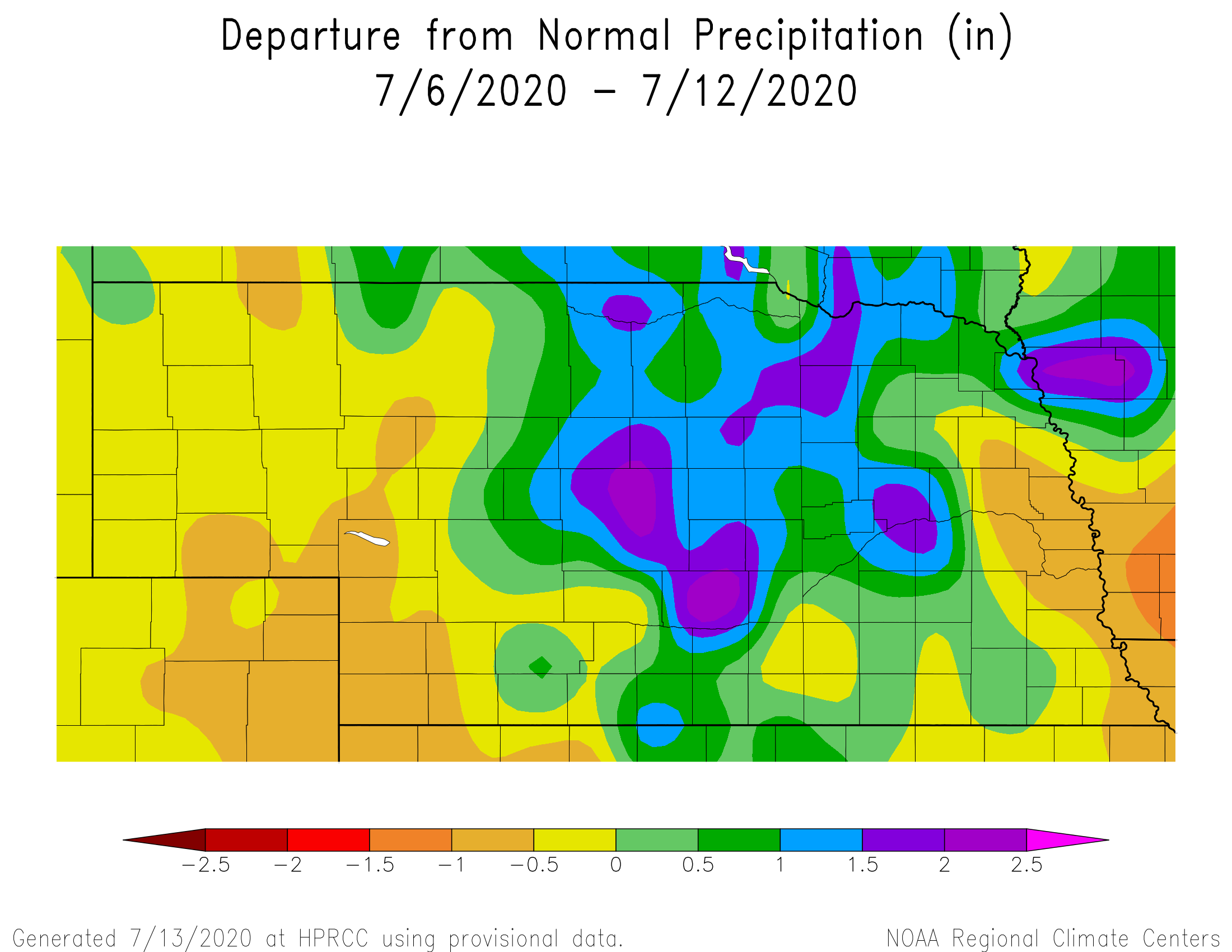
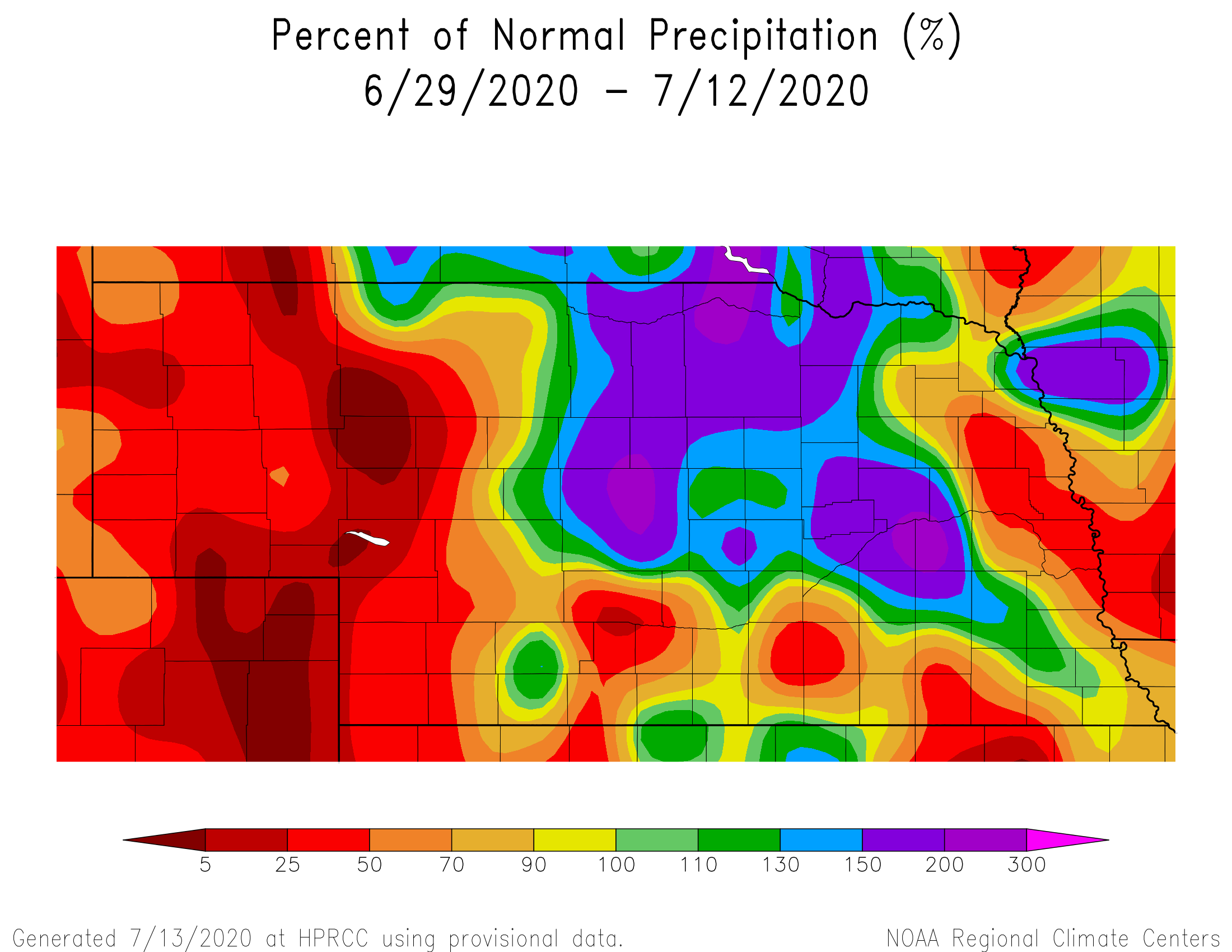
With all of the active weather across the state during the past week, precipitation across the eastern and western third of the state was below normal. However, a widespread area of central and north central Nebraska received normal to 300 percent of normal moisture. Areas receiving over 200 percent of normal caught multiple rounds of convection from systems crossing the state.
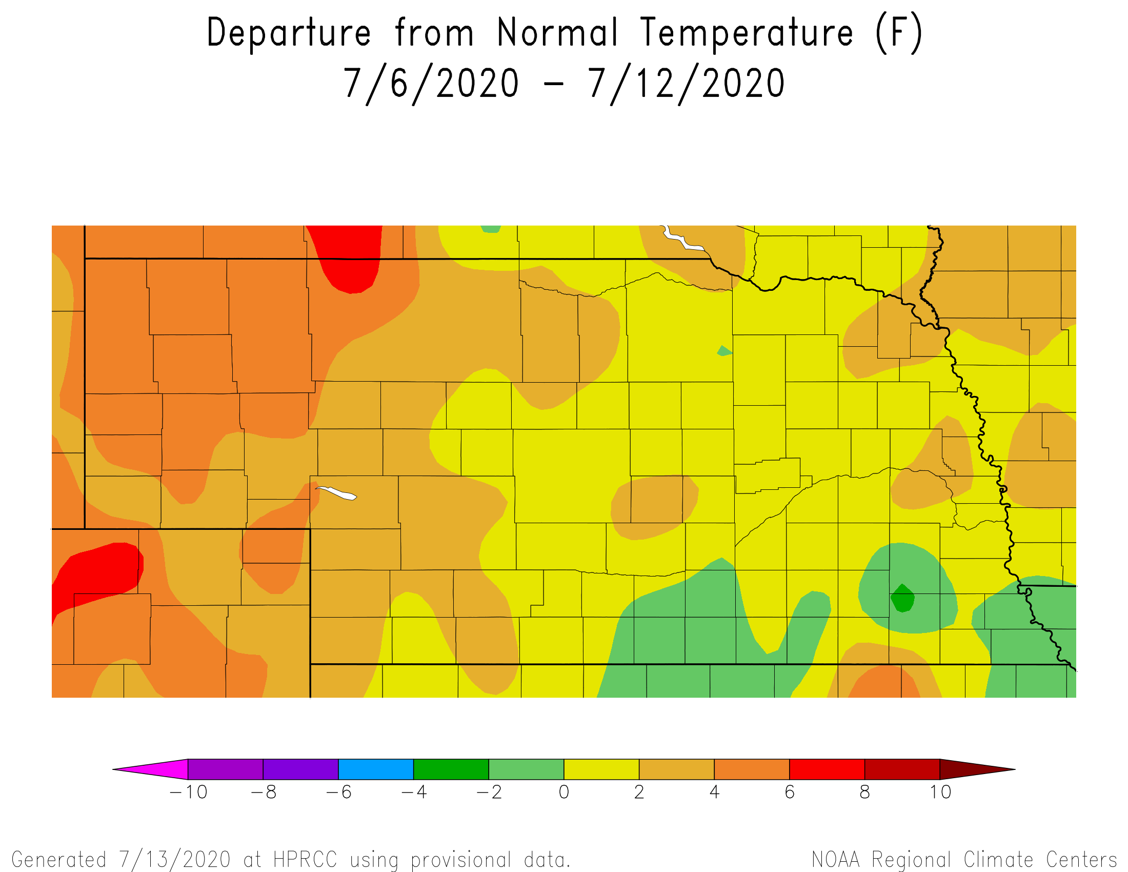
Temperatures were above normal this past week, with the western 1/3 of the state averaging at 2-4 4 F above normal, with the greatest departures from normal occurring over the northern ¾ of the Panhandle region. Temperatures were closer to normal across the eastern 1/3 of the state. The combination of above normal temperatures across the western third of the state couple with below normal precipitation led to a reduction in pasture health and an expansion of drought conditions.
Crop Progress
According to the Nebraska Agricultural Statistics Service (NASS) state crop conditions declined for all crop types reported on a weekly basis. NASS reports the corn condition declined from the previous week as the good/excellent rating fell from74 % to 70%. Corn reaching the silk stage was reported to be 19%, compared to 8% last year, and the 5-year average of 29 percent. Soybean condition dropped 3 points from 76% to 73% good to excellent. NASS reported that 57% of the soybeans were blooming, compared to 23% last year, and the 5-year average of 43 percent.
The largest crop rating declines reported by NASS were for pastures and wheat. The hot and dry weather across much of the western 1/3 of the state came during the final two weeks of grain fill, likely lowering yields. Wheat was rated 45% good to excellent, a drop of 11 percentage points in the last two weeks. Rangeland conditions followed a similar response with NASS reporting that 48% of the crop was in good to excellent condition, a drop of 18% points over the last 14 days.
Of course, with declining crop ratings, top soil and subsoil ratings also declined. According to NASS, topsoil conditions declined to 53 percent adequate and 1% surplus. Subsoil ratings stood at 46% good and 1% surplus. During the past 14 days, topsoil moisture in the adequate to surplus category dropped only 2 percentage points, but subsoil moisture ratings dropped 22 percentage points. During the past 30 days, much of the eastern and southern Panhandle region has received less than 50% of normal.
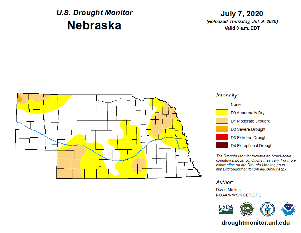
The persistent dryness has resulted in an expansion of “abnormally dry” and “moderate drought conditions on the latest U.S. Drought Monitor issued July 9 based on condition through 8:00 am July 7. Moderate drought conditions now encompass areas of the northwestern Panhandle, southwestern Nebraska, as well as parts of south central and northeast Nebraska. Rainfall during the last week will likely lead to improvements for parts of central, south central, and northeast Nebraska, while expansion is likely across the Panhandle where Extension Specialists with the University of Nebraska indicate rangeland hay yield declines of 40-75%.
Outlook
The GFS 500 mb model run for the morning of July 14 featured an upper air low center over the southern Canadian Prairie region. This upper air low is projected to slide east-northeast toward southern Ontario, only to be replaced by another upper air low moving southeastward from British Columbia, Canada during the July 14-22 period. Although there appears to be several days where temperatures move into the mid 90’s and above, they are quickly replaced with several days of normal to slightly below normal temperatures.
Heat currently doesn’t return to the central United States with any longevity until July 23 when the upper air low over south central Canada pushes east and allows for upper air high pressure to build northward from the southeast and southern Plains. If the GFS is correct, this may represent the longest stretch of 90 plus high temperatures of the season. It also represents the best chance in the model run for 100 plus temperatures to occur, especially July 25-28.
Narrowing down the daily weather forecasts during the July 14-29 period, perhaps the greatest precipitation chances occurring statewide is forecasted by the GFS model to occur July 21-23, as the upper air trough currently positioned over south central Canada is pushed east and replaced by another upper air low. This will drive cooler air into the region and place Nebraska on the southern periphery of active weather forecasted for the northern Plains and upper Mississippi river valley.
Lesser chances of moisture are forecasted to occur July 15-17 as the cold front that moved through the state July 13 stalls out across northern Kansas and returns northward as a warm front. Thunderstorm chances appear to be greatest across north central and central Nebraska during the overnight hours of July 14th into the morning hours of July 15th, with areas south of I-80 having the best odds for measurable moisture July 15th into the first half of July 16th. The GFS model also points toward a chance of moisture across north central Nebraska July 17, but less than a quarter inch of moisture is forecasted for most of the region.
Temperatures will return to the 90’s July 18-20 as ridging aloft builds into the central U.S. prior to the next upper air low moving into south central Canada. After a cool down July 21-23, the GFS model develops a strong ridging pattern across the southern and central Plains, along with much of the Rocky Mountain region from New Mexico through Wyoming.
If the GFS model verifies, widespread 90’s are likely east, with several days of upper 90’s to low 100’s likely for the western 1/3 of the state. Little to no moisture is projected for the state, outside of slight chance over north central Nebraska the evening of July 28 through the morning of July 29th. Dew point temperatures are expected to return to the upper 60’s to low 70’s east of the Panhandle creating uncomfortable conditions for humans and livestock.
Further out into the future, the Climate Prediction Center (CPC) will be issuing their August and August-October outlooks February 16. With CPC issuing a La Nina alert last week, it will be interesting to see whether dry and hot conditions will be depicted for the southern and central Plains region. This area has a strong relationship to La Nina episodes, when dryness generally prevails due to a weaker southern jet stream from the fall through spring period. CPC increased the odds of the event from40-45% last month to the currently issued odds of 50-55 percent.
Source: Al Dutcher at Nebraska State Climate Office