General Observations
The warm conditions Nebraska experienced during the first half of June came to a sudden halt as a strong upper air trough pushed through the central Plains. Severe thunderstorms developed over north central and northwest Nebraska June 18th as the surface cold front pushed slowly eastward. These storms dissipated before reaching central Nebraska during the post dawn hours. Severe thunderstorms developed along the front during the late afternoon of June 19th across southeastern Nebraska, largely bypassing the central part of the state.
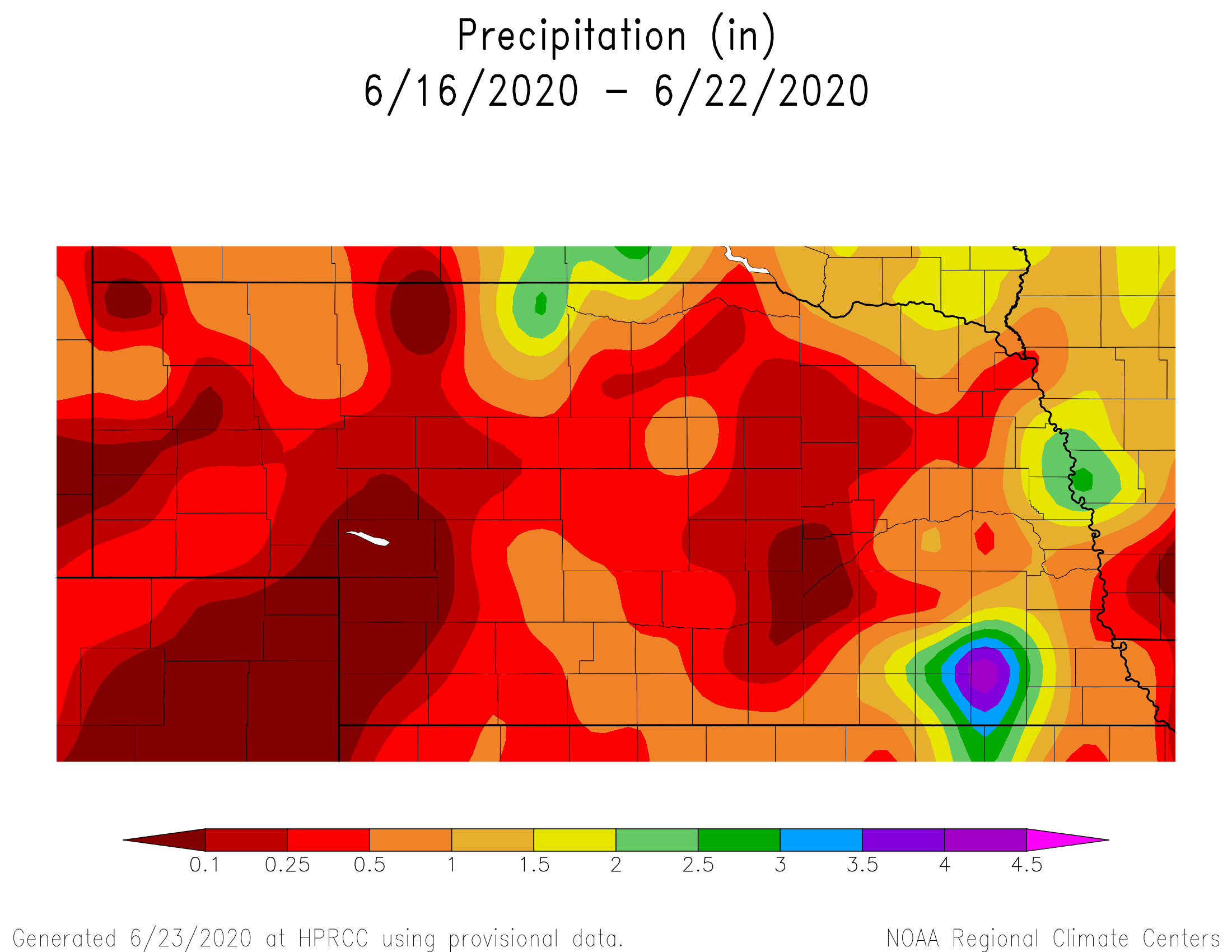
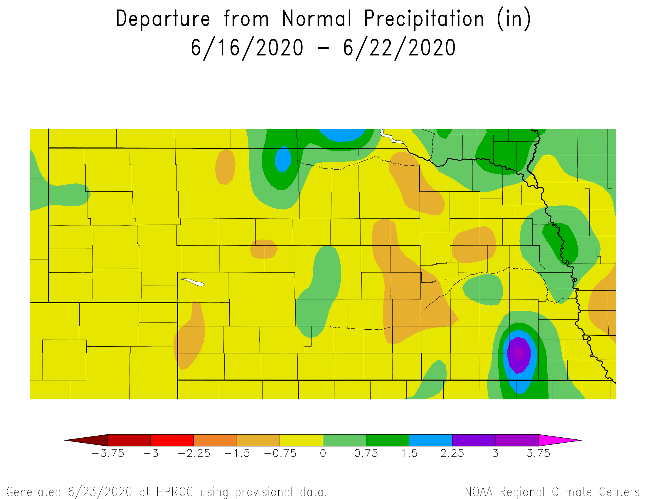
The June 19th severe weather outbreak across southeastern Nebraska dropped a concentrated area of 3 to 8 inches of rainfall over a four county area including northeastern half of Jefferson county, the southern third of Lancaster county, southeastern quarter of Otoe county, and all of Gage county. A concentrated area of 4 to 8 inches fell across extreme northwestern Jefferson county, extreme southeast Saline county, the northern third of Gage county and the southwestern corner of Otoe county. Damage assessments have not been received yet, but widespread lowland flooding and some crop losses should be expected.
Grassland conditions likely remained steady due to limited precipitation and cooler temperatures. A widespread rainfall event delivering several inches of moisture would help replenish depleted soil moisture, especially on lighter soils. If forecasted precipitation events over the next 10 days fail to materialize and temperatures return to the 90s, significant declines in pasture conditions during July would be expected.
Crop specific water use calculations indicate that evapotranspiration rates were below normal this past week, due to much cooler temperatures and several days of cloudy conditions, especially across the eastern half of the state. Corn crop water use should approach 0.20 inches/day for early May emerged crops by the end of this week and 0.25 inches/day by July 4th. Subsoil reserves are still adequate for most dryland crops as roots search deeper into the soil. However, below normal moisture with temperatures returning to the upper 80s or greater will quickly deplete these reserves.
Crop Progress
According the Nebraska Agricultural Statistics Service (NASS), corn ratings improved a few percentage points from last week, 71 to 74% good to excellent. This likely reflects recent scattered rainfall and a break from 90°F plus daily highs. Soybean condition decreased 1 percentage point from 78 to 77 percent good to excellent, essentially indicating a steady crop rating from last week.
The break from extended hot, dry, and windy conditions was welcomed by producers. Although rainfall was reported at most locations statewide this past week, large variations were noted over short distances. The most concentrated area of excessive moisture was across southeastern Nebraska, while western Nebraska wasn’t as fortunate.
Soil moisture data from NASS indicated that there remains a sizeable percentage of soils that are short of moisture at the surface and down deeper. Topsoil conditions statewide were reported to be 8% very short and 30% short. Subsoil moisture was rated 4% very short and 21% short. With crops approaching the point of full water use (most within the next 2 weeks), timely moisture will be needed to advert additional declines going forward.
Outlook
The GFS model forecast over the next two weeks indicates several decent opportunities for moisture statewide, with the temperature roller coaster likely to continue. The first opportunity for widespread moisture occurs during June 25th – 27th in response to an upper air trough moving through the central United States.
Gulf of Mexico moisture will surge northward and interact with the slow moving cold front to create widespread thunderstorm activity across the state. Currently, the GFS indicates scattered thunderstorms developing across western Nebraska, with more organized convection likely June 26th. Eastern Nebraska will likely see convection move into the area during the evening of June 26th and linger through the next day until the cold front pushes east.
This upper air trough is expected to weaken as it heads toward the Great Lakes in response to high pressure aloft building over the northern Great lakes and southern Ontario. At the same time, another strong upper air low will move into the Pacific Northwest. This will help build a ridge of high pressure over the central U.S., resulting in warmer temperatures (upper 80s to low 90s) from June 28th - July 1st. With weak northwest flow aloft, it is possible that energy dropping southeast along the front side of the ridge may generate daily chances of isolated storms, especially across eastern Nebraska.
The GFS model pushes the northwestern U.S. upper air low eastward during the July 2-5 period, Temperature will warm during the period, with upper 80’s and low 90’s developing into the 4th of July weekend under temporary ridging aloft. The upper air trough is forecasted to move into the northern Plains, leading to a stormy forecast period from July 6-8 for the northern Plains, including the northwestern half of the state.
Eastern Nebraska is also projected to receive moisture with this system, potentially heavy on July 7th and 8th. From July 9th – 12th, the GFS begins to build an upper air ridge over the southern and central Plains, potentially pointing to a return to widespread 90s July 11th and 12th. Since the ridge is forecasted to build into the region at the end of the model forecast period, it is likely that the upper air ridge will hold for several more days, at a bare minimum.
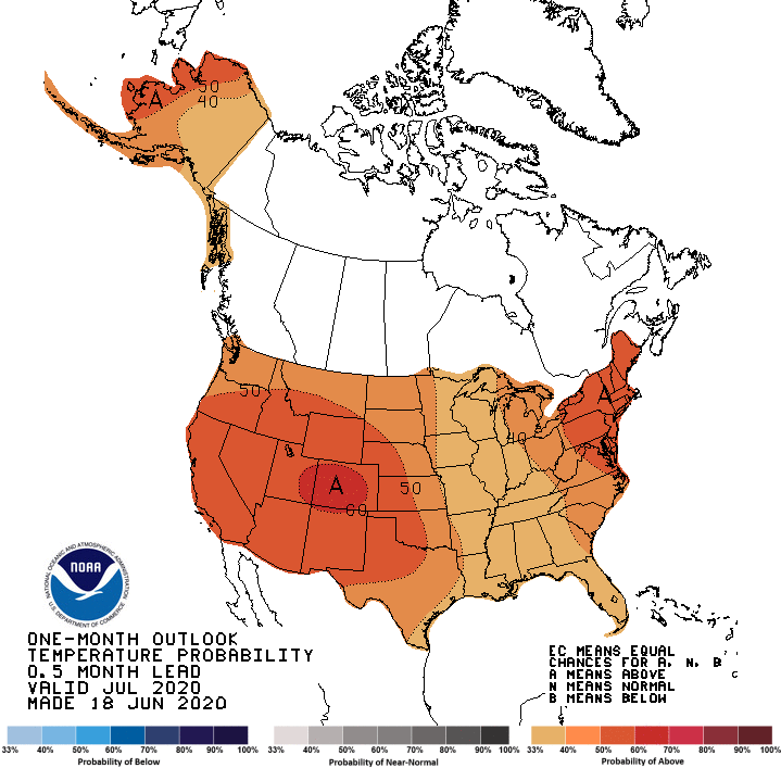
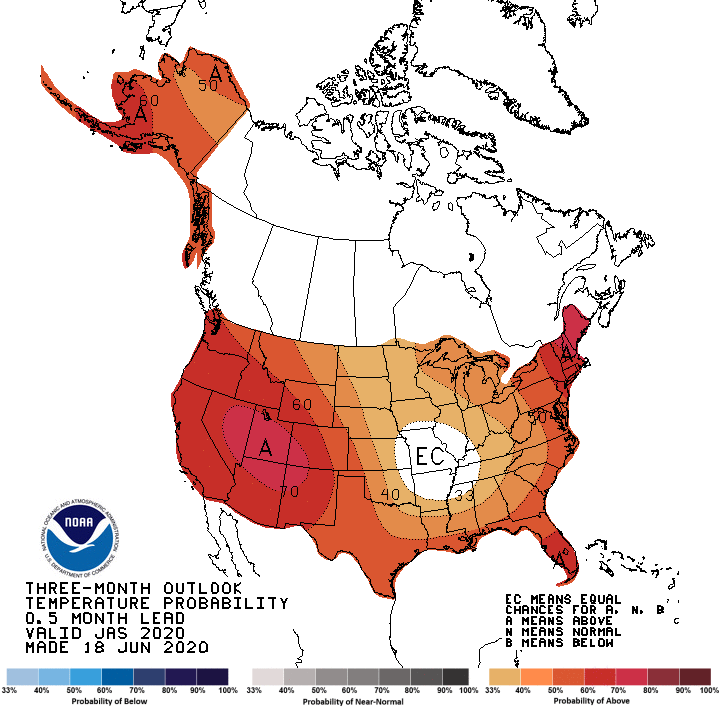
Further out, the Climate Prediction Center (CPC) issued their preliminary one month and three month seasonal outlooks last Thursday (June 18). Looking at the July and July through September periods, the most consistent part of their outlook is for above normal temperatures with high probabilities across the western half of the United States.
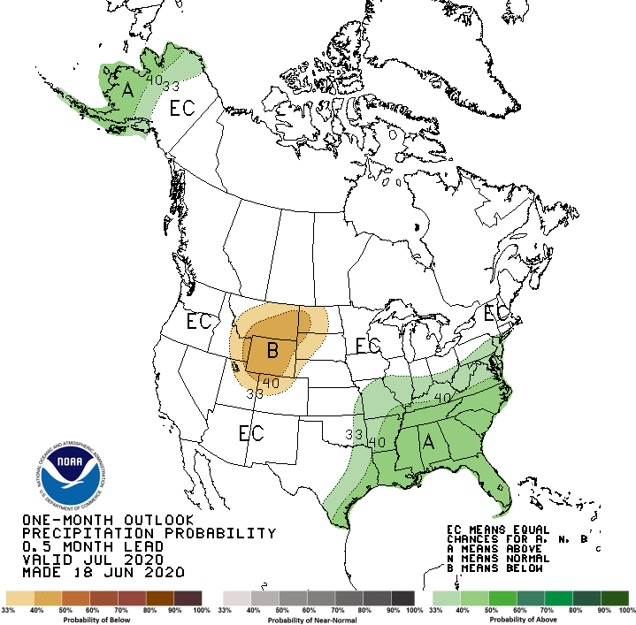
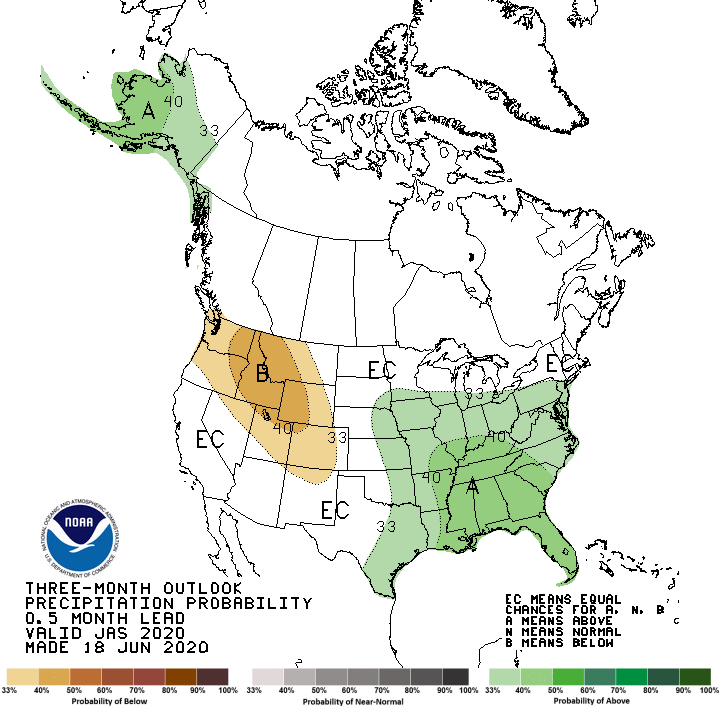
For Nebraska specifically, CPC indicates above normal temperatures are favored, with the highest odds assigned to the western half of the state. CPC’s precipitation outlook calls for below normal precipitation over the northern Rockies. This area extends into the northwestern half of the Panhandle region, although the odds are weakly tilted toward the dry side. Elsewhere, there are equal chances of experiencing above normal, normal, or below normal precipitation.
The 3-month outlook from CPC indicates that below normal precipitation is favored for most of the Rocky Mountain region, with the highest probabilities assigned to the northern Rockies. Above normal precipitation is favored for the eastern half of Nebraska, while no defined trend was predicted for the western half of the state. However, the central/northern Rockies dryness area is brought right up to the western Nebraska border.
It appears that CPC’s outlook indicates they believe the western U.S. will be strongly influenced by an upper air ridge, with an upper air trough positioned over the central/eastern corn belt. If their above normal temperature and below normal precipitation outlooks verify, it should lead to above normal temperatures and a tendency toward below normal moisture for the western half of the state due to the lack of thunderstorm development along the front range of the Rockies.
Source: Al Dutcher at Nebraska State Climate Office