Warm and dry weekend
Upper level ridging will prevail across the north central U.S. and Helene's remnants will remain well to our southeast. Therefore, sunshine will be the rule, temperatures will remain in the 80's in the afternoons and pleasant at night this weekend. Temperatures are likely to get above 90 in parts of the Panhandle where we have the worst drought conditions.
Football forecast
The football team will be in West Lafayette, IN this weekend to play Purdue. Remnants of Helene will play a role Saturday across that region with showers probable during the game. Nebraska should bounce back for a win after last Friday night's disappointing loss. Camille is less confident than me in our chance of winning by a big margin:
Eric's prediction: Nebraska 38 Purdue 17
Camille's prediction: Nebraska 28 Purdue 25
Manic Monday
The Bangles weren't singing about the weather in their 1986 hit but Monday will likely feature very high fire danger in western and north central Nebraska. The culprit is a cold front that will be traversing the state during the day. It won't be be bringing any rain but the front will usher in gusty winds from the northwest and low relative humidity, especially in north central and western Nebraska. Given how dry the land surface is across the state, any fires that start on Monday would spread easily where wind speeds are higher. So please be careful Monday afternoon. Temperatures will drop behind the front and frost will be likely on Tuesday morning over the Sand Hills and eastern Panhandle if winds calm down enough. Frost is unlikely east of Highway 183. Highs behind the front will be seasonal in the upper 60's to mid 70's on Tuesday before bouncing back into the 80's on Wednesday.
Harvest Window
Temperatures will drop back to the 70's later next week after another (mostly) dry frontal passage on Wednesday night into Thursday morning. There will be a slight chance of showers in northeast and east central sections of the state. Any rain that does fall will be a tenth of an inch or less. Right now it appears temperatures will remain a bit above seasonal levels in the mid 70's to lower 80's next weekend. Should be very nice for the festivities in Lincoln next Saturday. Harvest should progress along nicely next week too and that harvest window looks to extend into at least the first week of October.
Fortnight
When will we have a chance of significant rain next? For that question, perhaps Taylor Swift has the best answer: Fortnight. Ok, she wasn't singing about the prospect of drought getting worse in Nebraska. But weather did get a mention in the tune and Camille is a Swiftie. So the song title is worthy of an appearance in the update.
Back to the topic at hand: The warm, dry weather looks likely to persist through at least the first full week of October. I am suspicious that will be the rule for the majority of the month of October. But the ECMWF AI does have a decent upper level low entering the Central Plains on October 10th, which would set up the eastern half of Nebraska for a shot at meaningful rainfall. We would definitely need the moisture by then. Don't recommend betting any money on that moisture just yet though. The better bet is on not getting any meaningful moisture for at least a fortnight and possibly even longer.
Drought Update
Since last week's forecast ended up being dead wrong for all but southeast Nebraska (where 1-2 inches of rain was common), we not only didn't see any drought improvement across the state, we saw more degradation. A bit over 40 percent of the state is now in drought on the current U.S. Drought Monitor (up from 35 percent last week), with northeastern Nebraska seeing the largest expansion of moderate drought (D1) over the past week. Additionally, conditions warranted a degradation to severe drought (D2) in southeastern Holt, southwestern Knox and northern Antelope counties where drought. Additional degradation occurred over the past week in the Sand Hills and in northern Lancaster County.
Given the warm, dry forecast favored by the CPC in the next few weeks and the acute lack of soil moisture, it is reasonable to project that 50 percent of the state (or more) will be in drought by the middle of October. A quick comparison of current root zone soil moisture percentiles from SPoRT LIS with those from this time two years ago shows that conditions are just as bad if not worse across most of Nebraska and western Iowa. The warm, dry weather will be a bonus in getting crops dried down naturally and quickly. But it also increases the risk of wildfires and it also means that we are likely to have some part of the state entering the cold season in severe drought (or worse) for the fifth consecutive season.
Temperature and Precipitation Summaries
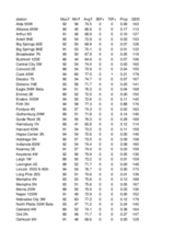
Attached are pdf's containing the maximum/minimum temperature, average temperature, number of days with maximum temperatures ≥95F, minimum temperatures ≥70F, degree days, and total precipitation for each Mesonet station over the period from September 15-21.
Below are the temperature and precipitation extremes around the state over the past week:
Maximum Daily High Temperature: 99F, Chadron Municipal Airport
Minimum Daily High Temperature: 57F, Imperial
Minimum Daily Low Temperature: 28F, Agate 3 E
Maximum Daily Low Temperature: 72F, Falls City Brenner Field
Maximum Weekly Precipitation: 2.50", Falls City 5.5 NE
Minimum Weekly Precipitation: 0.00", Multiple Locations
Eric Hunt, University of Nebraska Extension
Camille Shifrin, Nebraska State Climate Office


