End of growing season possible this weekend
Mother Nature acted like the first few days of October were the first few days of August. Then over the course of the last 24 hours a frontal passage brought much of the state needed moisture and dropped our temperatures back to more seasonal levels. But in terms of temperature decline, this frontal passage was just the appetizer. The main course is entering the state tomorrow in the form a sharp upper trough and associated surface cold front that will give us our first true chill of the season (for most of the state). There is a good chance of showers along the front across the northern half of the state overnight Thursday and across the southern half of the state Friday morning. Rainfall amounts should mostly be under a quarter inch but with strong NW winds, it won't be a refreshing summer rain.
Winds will remain strong from the northwest on Friday afternoon and skies should start to clear along with a drop in relative humidity. Thus, even with a quick shower on Friday morning, there will still be some enhanced fire risk due to the higher winds and lower humidity levels. By Friday night winds will start to back off and temperatures will start to drop into territory we haven't seen yet this season. The question is how chilly do we get.
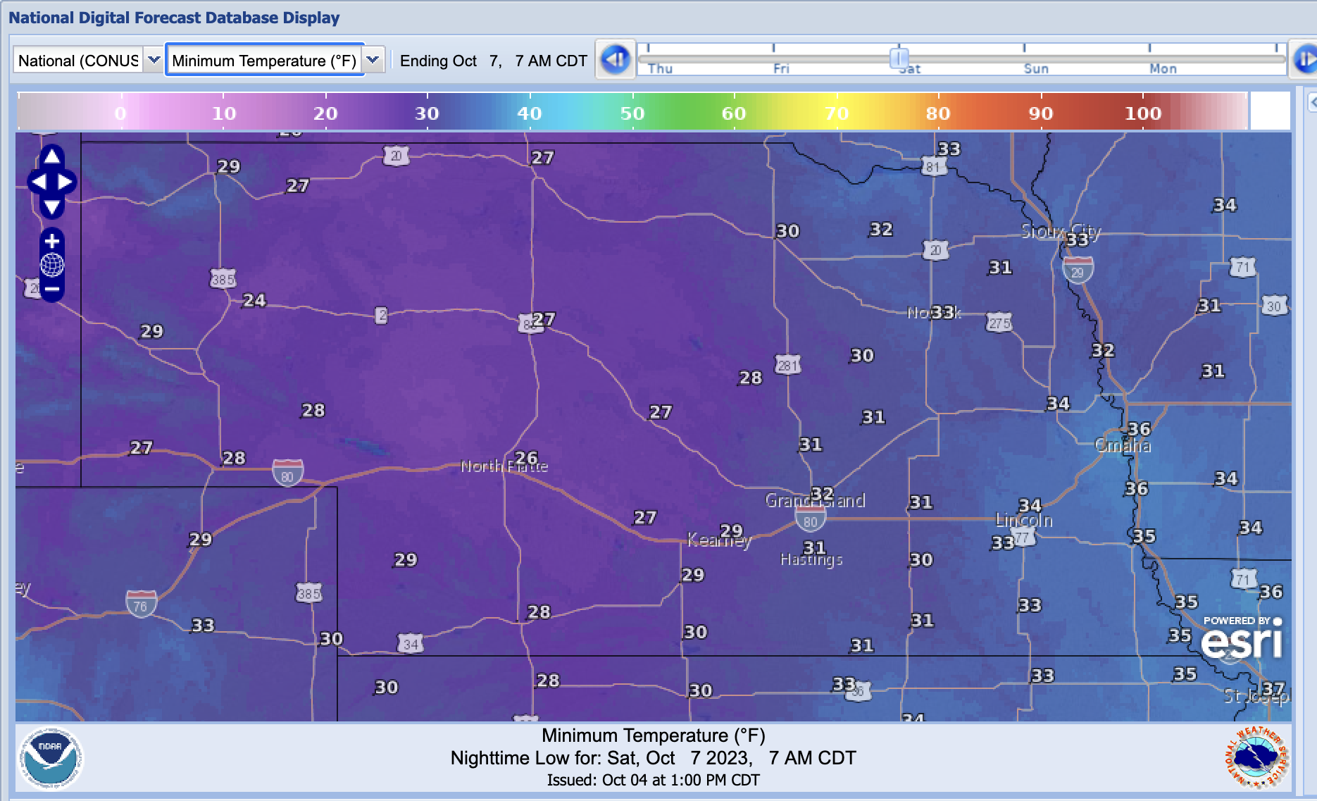
Current forecast is for temperatures to be sub-freezing on Saturday morning for all but the southeastern quadrant of the state
The surface high will be displaced to our south by later Friday night so winds will not likely be dead calm for most of the state. Cloud cover isn't expected but any unexpected stratus formation would limit the temperatures from crashing as much as currently forecast. Nevertheless, this air mass looks to be cool and dry enough for temperatures to easily drop below 40 statewide and much of north central and western Nebraska are quite likely to have a light freeze Friday night. A light freeze is also somewhat likely in portions of northeast Nebraska and southwestern Nebraska as well under this scenario. The Lincoln and Omaha metros are more likely to be in the 34-37 range but that is chilly enough for some frost if winds are light enough. Be warned though that if winds do go perfectly calm between 3 and 6 AM on Saturday morning, the air mass will be dry enough to let temperatures drop below freezing for all but the very far southeast corner of the state and for temperatures to be in the 26-28 range as far southeast as Wahoo or Lincoln.
So my best advice is to follow the local forecast carefully in the next 48 hours and take appropriate measures with sensitive vegetation. For much of north central and western Nebraska, a light freeze has often occurred by now and it's definitely not unusual to have already had a light freeze from Grand Island to Omaha in the first week of October either. So this is certainly not an historically cool air mass. It just is going to be a bit of a shock given how warm it was for most of the last week for most of the state. Temperatures look to rebound nicely by Sunday though the eastern sixth of the state may get a light dessert next Monday in the form of a glancing blow from another cold front. For more information on the frost/freeze climatology, visit the following page from the Midwest Regional Climate Center: https://mrcc.purdue.edu/VIP/frz_maps/freeze_maps#frzMaps
Eric Hunt, University of Nebraska Extension