Summary
A storm system will be moving from the southwestern U.S. into the central U.S. early next week and could spell trouble for much of the region on Monday and Tuesday. At this point, the potential for significant travel impacts appears to be highest across the southeastern quadrant of Nebraska and lowest west of North Platte.
What we know:
1) A potent system is coming out of the southwest and will be moving northeast into the central U.S. by Monday
2) An extended period of precipitation is possible starting Sunday night in the eastern half of Nebraska. Heavy snow amounts are possible in a band from Kansas and Nebraska into the Great Lakes region.
3) It will be cold next week and possibly very cold by MLK weekend over the entire state
What we don't know:
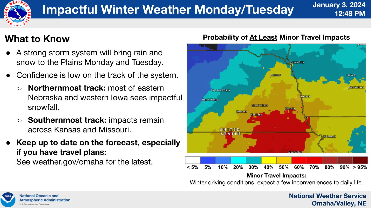
1) Exact storm track: Since we are still more than 4 days out, the exact storm track is still uncertain. As always, this will have an impact on how much snow we get in parts of the state and if there is any period of rain or freezing rain/sleet first. Right now the surface low is expected to track from the Texas Panhandle and Oklahoma northeast toward the St. Louis area from Monday into Tuesday with the 500-mb trailing closely behind. This setup is favorable for central and eastern Nebraska to be in the moist sector for several hours and there appears to be a decent fetch of moisture from the Gulf of Mexico. So there is certainly a possibility for several inches of snow in the southeastern quadrant of Nebraska and some snow for everyone east of North Platte. A more northerly track will mean more impactful snow and wind.
2) Snow amounts: There is a potential for this storm to produce a foot of snow in the southeast quadrant of Nebraska. But I think it's too early to get excited for a repeat of the January 2021 snow amounts as we would need the track to be further north than what is currently forecast for that to be the case. Nevertheless, I'd plan on maybe 1-3" in Broken Bow and Kearney, 3-6" in Grand Island and Norfolk, and 5-8" in York, Lincoln, Omaha, Nebraska City, and Columbus. We will also need to watch for the possibility of a "warm nose" of air aloft into the eastern section of the state, which could mean a period of sleet or freezing rain. This is not the current forecast but it is something to keep an eye on. A period of sleet or freezing rain would cut down on snow accumulations, as we saw in parts of southeast Nebraska last January.
3) Additional snow next week: It appears that Monday is the main course but Mother Nature may treat most of the state to 1-2 additional rounds of snow next week. They do not appear to be significant snow producing systems but everyone other than maybe parts of the Panhandle may get a few more inches.
Best advice:
As always the best option is to stay on top of the forecast and be prepared to possibly need to remove several inches of snow if you live east of Grand Island and south of Norfolk. I would suspect we will have a much better idea who is in for what by Friday night into Saturday morning.
Eric Hunt, University of Nebraska Extension