
Outlook
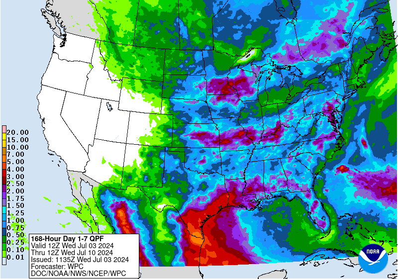
With the 4th of July holiday tomorrow, this week's outlook/update will be short. Biggest stories will be chances for storms across the eastern 3/4 of the state in the next 24 hours and then again on Saturday night in the eastern half of the state. Severe weather is possible later today in the west central and central sections of the state and in eastern Nebraska on Saturday. WPC shows most of the state getting between 0.50-1.25" over the next week, except in the western Panhandle where minimal precipitation is expected. Only concern is that the WPC may be underestimating precipitation in eastern Nebraska as it is possible to get nighttime convection with the northwest flow regime we'll be in early next week. Sometimes models struggle to pick that up more than a few days out. Temperatures will be predominantly below seasonal averages statewide for the next few days and will remain below average in eastern NE through the middle of next week. Ideal weather for pollination. Temperatures likely will be back into the upper 80's and 90's by late next week and the back end of next week is likely to be dry statewide.
Moisture and Drought Update
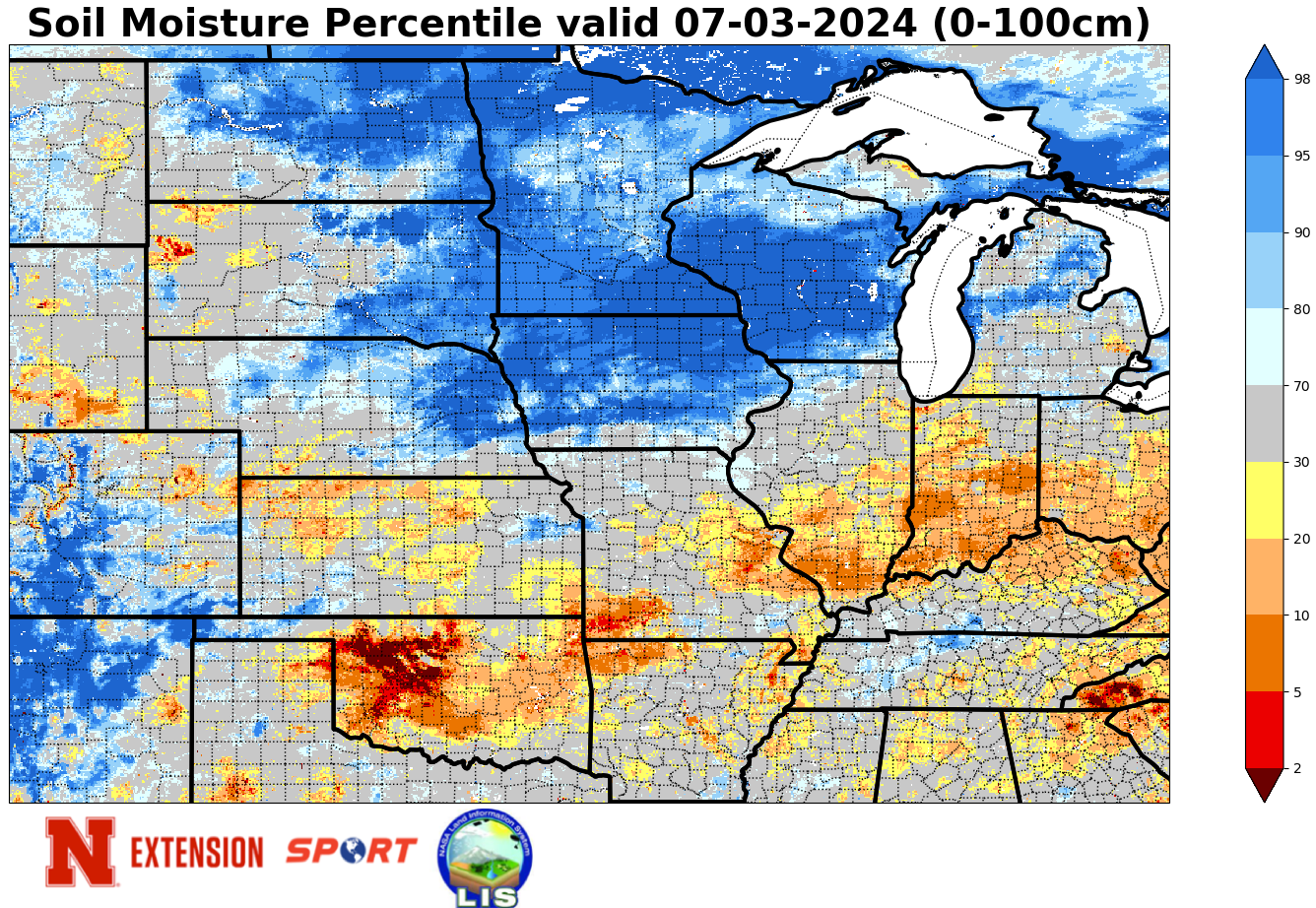
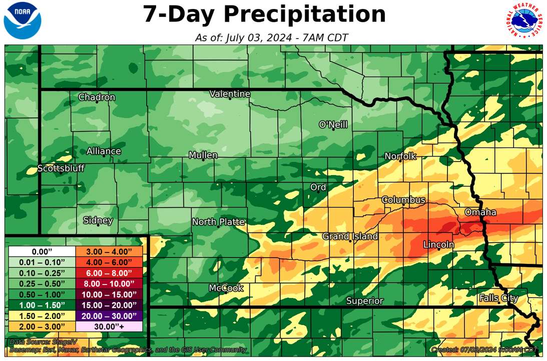
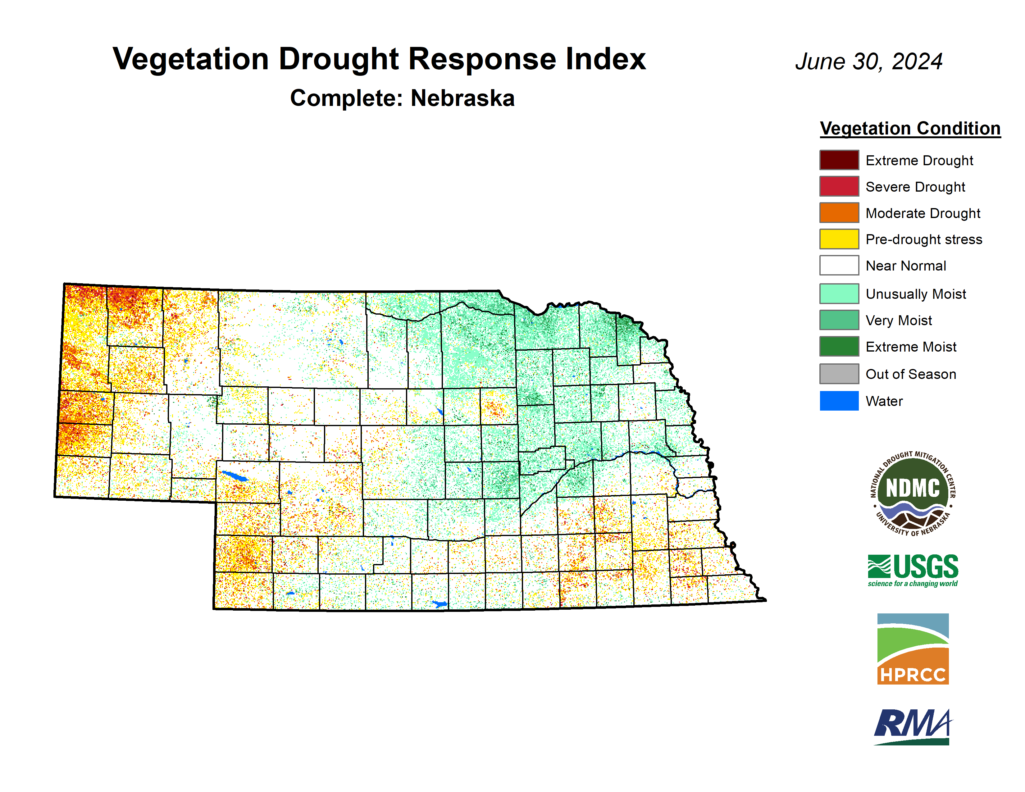
The past two days brought precipitation to much of the state, with most of central and eastern sections in the state getting over an inch. Heaviest precipitation was along the I-80 corridor from Seward to Sarpy counties where 4-7" of rain was common. This led to some flash flooding issues and will put additional pressure on the Missouri. Thankfully this was an area that had not been as wet (in some cases a bit dry in the previous month) so the ground was able to hold more of it than had this occurred further north where excessive rainfall had occurred in the second half of June. Soil moisture percentiles are currently over the 70th percentile for most of eastern and north central Nebraska and in many areas over the 90th. So there is no concern for moisture going into pollination this year for most of our major corn/soybean areas. Some of the area long the Kansas border from Hebron to Fairbury where abnormal dryness is still depicted on the USDM might be the exception. Speaking of drought, much of the remaining abnormal dryness (D0) in eastern and south central on the Drought Monitor was taken out this week. Abnormal dryness was introduced to the area southwest of North Platte where precipitation has been less reliable the past few months. Soil moisture percentiles also reflect the recent dryness, hence my recommendation for the USDM author to add the D0. Status quo in the Panhandle where a pocket of moderate drought persists.
NASS Crop Progress update
Condition ratings for corn came in at 80 percent good-excellent (G-E) against 4 percent poor-very poor (P-VP) while soybean checked in again at 78 percent G-E and 4 percent P-VP. Sorghum is rated at 84 percent G-E against 0 percent P-VP. Winter wheat harvest is progressing ahead of average (13 percent complete) and checked in at 67 percent G-E against 8 percent P-VP. Good yields are anticipated this year. 90 percent of oats have headed and are rated as 77 percent G-E and 3 percent P-VP. Pasture ratings of the season show 68 percent G-E against 6 percent P-VP. That is an improvement in conditions over a week ago. VegDRI continues to depict very good pasture conditions in the northern and eastern Sand Hills regions but poorer conditions in parts of the Panhandle where drought has developed. VegDRI also shows good conditions on crops across much of the state, except in the western Panhandle where VegDRI indicates more severe levels of water stress.
Temperature and Precipitation Roundup
Below are the temperature and precipitation extremes around the state over the past week.
Maximum Daily High Temperature: 99F, Scottsbluff W B Heilig Field
Minimum Daily High Temperature: 68F, Hayes Center
Minimum Daily Low Temperature: 43F, Alliance Municipal Airprot
Maximum Daily Low Temperature: 74F, Nebraska City 2NW
Maximum Weekly Precipitation: 7.89", Davey 1.2 NNW
Minimum Precipitation: 0.00", Multiple locations
Eric Hunt, University of Nebraska Extension