Weather Review
It is not unusual to experience strong temperature changes during the second half of the fall whenever an Arctic intrusion event pushes across the state of Nebraska. Such was the case this past week as a powerful upper air trough moved from the southern Rockies into the northern High Plains. Southerly winds of 30-40 mph ahead of this trough pushed high temperatures into the middle to upper 70’s November 9-10, before a strong cold front dropped high temperatures over 30 F on November 11th.
Mesonet stations operated by the state climate office showed a 40 F temperature difference over a 30 miles transect ahead of and behind the surface cold front across northeast Nebraska. In fact, the first sub-zero low temperatures this fall were reported the morning of November 12th based upon observations recorded at airport locations across the state. The Chadron airport reported -1 F and the Valentine airport reached -7 F. It is almost a certainty that National Weather Service cooperative observer locations across the northern Panhandle and northwest Sandhill region also recorded their first sub-zero readings this fall.
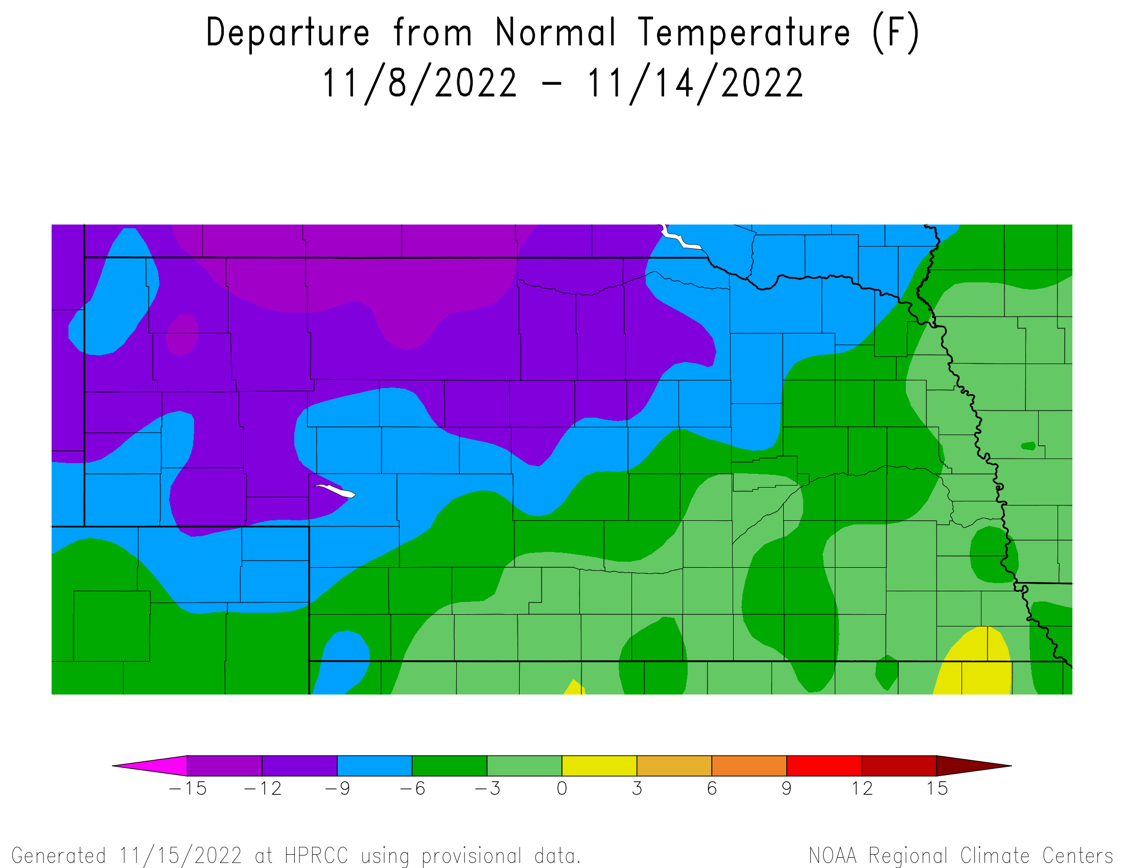
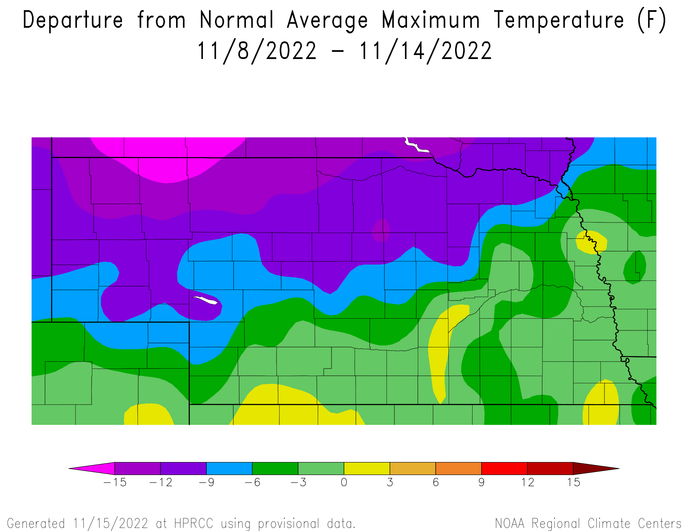
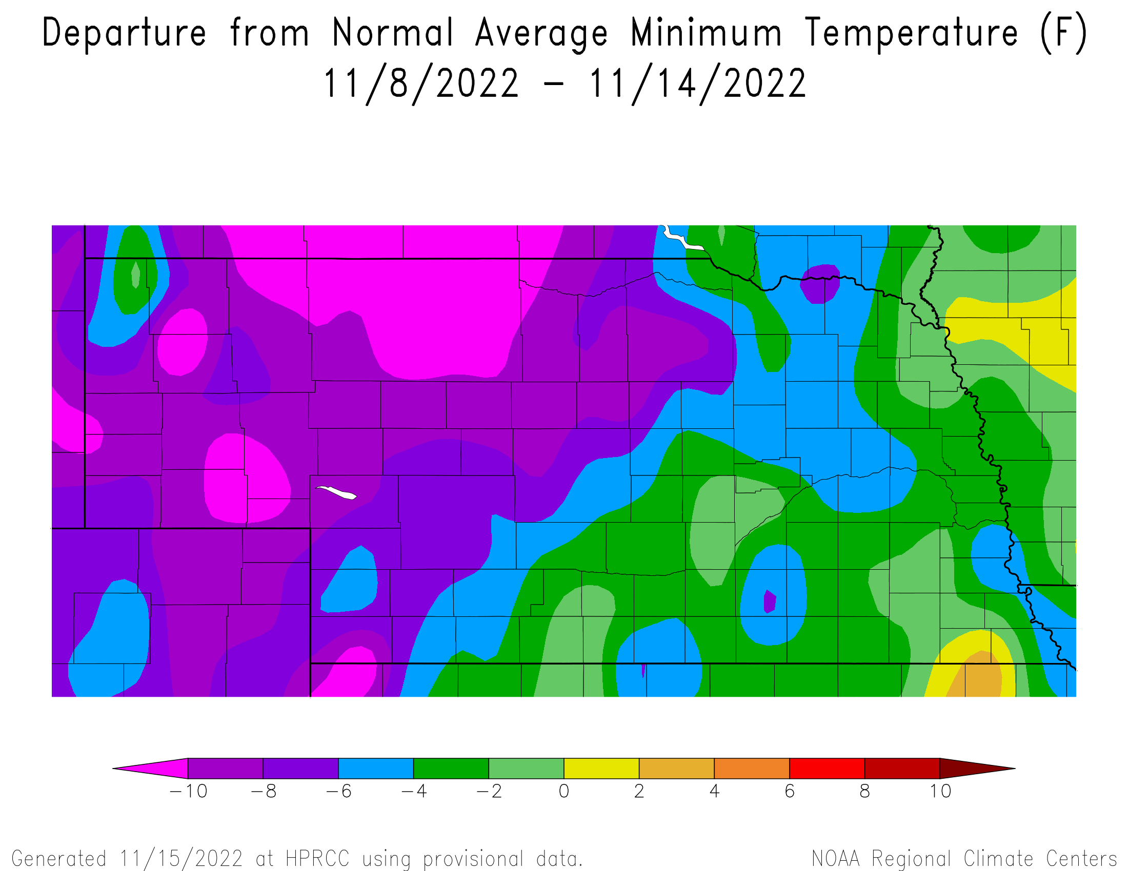
The cumulative impacts of the strong Arctic air surge can be seen in Figures 1-3, which detail anomalies for average temperatures, maximum temperatures and minimum temperatures. Average temperature anomalies in Figure 1 ranged from 6-15 F below normal across the northwestern 2/3 of the state and 2-6 F across the southeastern 1/3 of Nebraska. Figure 2 depicts maximum temperature anomalies from last week and their range is similar to average temperature anomalies, but each of the individual contour intervals covers more surface area across the northern half of the state. Minimum temperature anomalies in Figure 3 were approximately 5 F warmer statewide than the maximum temperature anomalies recorded last week.
The daily maximum temperature extremes for airport locations reported by the National Weather Service (NWS) are as follows: 11/7 (57 F: Falls City, Lincoln), 11/8 (77 F: McCook, Ogallala), 11/9 (80 F: McCook), 11/10 (71 F: Falls City), 11/11 (41 F: Scottsbluff), 11/12 (47 F: Scottsbluff, Sidney), 11/13 (51 F: McCook).
The daily minimum temperature extremes for airport locations reported by the NWS are as follows: 11/7 (21 F: Wayne), 11/8 (27 F: Kimball), 11/9 (19 F: Gordon), 11/10 (14 F: Sidney), 11/11 (1 F: Alliance), 11/12 (-7 F: Valentine), 11/13 (4 F: Tekamah).
Precipitation during this past week as reported by NERain observers indicates that the highest 24-hour total occurred 3.1 miles southwest of Hubbard between the morning of the 8th and 9th. Precipitation across northeast Nebraska developed ahead of a warm front pushing northward that was associated with a powerful snowstorm over North Dakota and eastern Montana. The remainder of NERain observers across the northern 1/3 of the state reported trace amounts of moisture, with most of it coming in the form of light freezing drizzle/rain. Icing was more significant across the eastern half of South Dakota, with multiple location in the northeastern quarter of the state reporting 0.25 to 0.50 inches of ice accumulation, coupled with downed trees and power lines. Light precipitation accumulations (under 0.15 inches) were reported across parts of central Nebraska November 10th and 11th as the surface cold front associated with the North Dakota event pushed through eastern Nebraska.
Figure 4 shows the cumulative moisture received last week across the state and only extreme northeast Nebraska had widespread totals exceeding 0.25 inches of moisture. Unfortunately, the western ½ of the state failed to received measurable moisture, as well as parts of south central, east central and southeast Nebraska. Until a significant precipitation event materializes, it should be expected that high fire danger days will develop on days where wind speeds exceed 20 mph and relative humidity levels drop below 20 percent.
The daily maximum precipitation values reported from NERain observers are as follows: 11/7 (0.38 inches: Hartington 0.5 NW), 11/8 (0.12 inches: Trumbull 0.3 SE), 11/9 (0.60 inches: Hubbard 3.1 SW), 11/10 (0.30 inches: Minden 2.2 ESE), 11/11 (0.12 inches: Craig 6.2 S), 11/12 (0.01 inches: Stanton 0.5 NW), 11/13 (0.00 inches: all stations).
Crop Progress
Harvest activity for warm season crops are on the verge of completion according to the Nebraska Agricultural Statistics Service (NASS) crop progress report issued on November 14th. As of November 13th, NASS estimates that the soybean harvest is complete, corn is 95% complete and sorghum is 93% complete. For comparison, a week ago (November 6th) NASS estimated that the soybean harvest was complete, corn was 90 percent complete and sorghum was 87% complete. Last year at this time, corn was 89% complete and sorghum was 90% complete. The corn harvest is 9 percentage points ahead of the 5-year average, while sorghum is 6 percentage points ahead of the long term average. Based upon current weather forecasts, the corn harvest should approach 97% completion and the sorghum harvest should reach 95% completion when NASS releases their next crop report on conditions through November 20th.
According to NERain observations this past week, most of the measurable precipitation reports received were located across extreme northeastern Nebraska with cumulative totals between 0.25 and 0.50 inches. Although the lack of precipitation has resulted in a rapid harvest of warm season crops this year, it has been insufficient to improve the condition of 2023 hard red winter wheat crop. NASS reports that as of November 14th, Nebraska's hard red winter wheat was rated 19% very poor, 19% poor, 40% fair, 20% good and 2% excellent. Compared to conditions a week prior, wheat rated "very poor" increased 2 percentage points, while wheat reported as "good" or "excellent" shrank one percentage point each.
There was a subtle improvement in the conditions of pastures and rangeland from a week prior according to NASS. As of November 13th, pastures and rangeland were estimated to be 45% very poor, 32% poor, 18% fair, 4% good and 1% excellent. Compared to November 6th conditions, "very poor" conditions decreased 2 percentage points, while "poor" conditions expanded an equal amount. The total percentage of pastures and rangeland rated very poor to poor remained unchanged from the prior week at 77 percent.
Topsoil and subsoil moisture estimates have yet to show significant recovery this fall from drought impacts during this year’s growing season. As of November 13th, NASS estimates topsoil moisture at 48% very short, 38% short, 14% adequate and 0% surplus. Compared to a week prior, there was a 2 percentage point expansion of the “very short” category and a 2 percentage point reduction in the “adequate” category. NASS currently estimates subsoil moisture at 50% very short, 40% short, 10% adequate and 0% surplus. Compared to a week prior, the “very short” category shrank 1 percentage point, the “short” category expanded 3 percentage points and the “adequate” category shrank 2 percentage points. Overall, the percentage of subsoil moisture rated either “very short” or “short” this week is 90 percent, an increase of 2 percentage points from conditions one week prior.
Outlook
There have been dramatic changes over the last 24-hours in respect to the 16-day forecast depicted by the GFS model. Yesterday, the GFS model indicated that 4 weather systems would move through the central Plains including today’s event, another on the 23rd, followed by two more waves on the 28th and 30th. Each of these waves were depicted as weak. Atmospheric ridging was also forecast to briefly follow the first 3 waves. The final wave (November 30th) was forecast to be followed by a strong upper air ridge and a return to above normal temperatures for the first week of December. With this morning’s GFS model run, the 23rd, 28th and 30th upper air troughs have been combined into a single storm system that would produce significant precipitation event across the state of Nebraska.
Since these weather model changes have occurred over such a brief period of time, I wouldn’t be surprised to see the GFS weather model issued this morning to change solutions over the next couple of days. That being said, we are at a time of the year (late fall to early winter) where weather systems can rapidly gain strength, especially when large temperature swings exist between Arctic air to our north and early fall like temperatures to our south. The extent of soil freezing with our current Arctic air intrusion will determine how effective this event will in regards to topsoil moisture recharge. High temperatures are forecast to return into the 40’s prior to the arrival of this system, which should reduce/eliminate any frost that is currently developing.
The upper air trough responsible for light snowfall across southeastern Nebraska is forecast to shift east of the state by this evening, but will pull a renewed push of Arctic air into the region. High temperatures are forecast to be in the middle 20’s north to lower 30’s south November 16-17, with single digit to negative single digit lows north to middle teens south. Another wave is forecast to rotate around the eastern U.S. upper air trough and to push through the state during the second half of November 17th into the first half of November 18th. The GFS model indicates that some light snowfall may be possible across the western 1/3 of the state, with liquid equivalent moisture forecast to be less than a tenth of an inch. High temperatures may drop into the low 20’s north to upper 20’s south November 18th, warming into the upper 20’s north to middle 30’s south November 19th.
The eastern U.S. upper air trough is forecast to begin weakening on November 20th, which will allow an upper air ridge from the west to build eastward into the central Plains. At the same time, an upper air trough is currently forecast to move into the western U.S. and slowly push toward the central/southern Rocky mountain region by November 23rd. High temperatures across Nebraska are forecast to warm into the middle 30’s northeast to lower 40’s southwest November 20th, potentially reaching the lower 40’s northeast to lower 50’s southwest November 23rd.
The GFS model then moves the upper air trough into the southern Plains November 24th and eventually into the western Great Lakes by November 26th. If the current GFS model depiction verifies, moderate to heavy rainfall would develop across the eastern 1/3 of the state on Thanksgiving, with wet snowfall likely across the western 2/3 of the state. The GFS model pulls Arctic air southward behind the surface cold front on November 25th, which would result in snowfall statewide. Because air temperatures are forecast to drop into the lower 20’s, snowfall will have less water content, but has the potential to produce more than six inches of snow accumulation across the central 1/3 of the state in addition to what may accumulate on Thanksgiving. The GFS model moves the storm east of Nebraska during the second half of November 26th, so snowfall accumulations would still be possible across the eastern 1/3 of the state.
After this storm system moves east of Nebraska, the GFS model hints at a return to above normal temperatures as we enter the first week of December. Another strong upper air trough will approach the west coast, which will push an upper air ridge over the High Plains region (Texas to North Dakota). How long this period of dry and warm weather lasts will be determined by how quickly the western upper air trough can progress eastward. Right now the GFS holds this trough along the west coast through December 3rd and past history of strong west coast upper air troughs would suggest at least 5 days before the system would begin to impact the High Plains region.
Al Dutcher, Agricultural Extension Climatologist, Nebraska State Climate Office


