The Heat Is on
After a brief return to seasonal temperatures today, tomorrow starts a warming trend and we get our first taste of late spring/early summer weather this weekend. Temperatures will likely hit or exceed 80F statewide on Saturday and Sunday and will make a good run at the 80's on Monday in the eastern half of the state. Warmest day is going to be Sunday when temperatures should cross the 30C (86F) mark over most of east central and southeastern sections of the state and the remainder of the state should be in the lower 80's. Areas along the Kansas border between Superior and Fairbury could make a run at 90F. By Monday temperatures will be a bit lower but that warmth will also have some humidity in eastern Nebraska so it likely will feel more like early June than mid-April. With breezy conditions and lower humidity levels on Saturday, there is an elevated fire risk. This risk should start abating a bit by Sunday as humidity starts ticking up and by Monday there will be other things to worry about. This includes filing taxes for procrastinators and the risk of severe storms.
Severe Storm Risk
By Monday afternoon, a reasonably strong trough will be entering the High Plains region and make a turn toward the northeast. Exact details are still a bit fuzzy this far out. But the Storm Prediction Center already is concerned about the threat of severe weather in the Western Corn Belt and the Central and Southern Plains. There will be decent low-level moisture to work with (much more so than last weekend) as dewpoints look to climb into the 50's into central portions of Nebraska and into the lower 60's across the eastern Nebraska. The sharp trough will ensure there is a lifting mechanism and dynamics for the possibility of thunderstorms. My initial hunch is this more of a tornado threat down in southern Kansas and Oklahoma and more of a large hail threat in the central Plains and western Corn Belt. Recommend paying close attention to the forecast later this weekend and keeping the weather radio nearby on Monday night.
The upside to the storms is most of central and eastern Nebraska should get some moisture. The WPC currently shows eastern portions of the state in the half inch to three quarters of an inch range and the ECMWF ensemble is more bullish on the probabilities of an inch early next week in the northeastern and north central sections where a longer period of moderate rain is more likely on Tuesday morning. The wild card is the southeastern quadrant of the state. A stormy scenario means locations around Columbus, York, Lincoln, Plattsmouth, Nebraska City, Wahoo, and Falls City have a good chance at 1" or more of precipitation. If storms don't materialize like currently projected or are much more isolated, then there is a risk of central and eastern Nebraska being left high and dry from this. In a fair world, Nebraska would have won a few NCAA tournament games in March and we could get the rain without the risk of severe weather. Alas!
Touch of... February?
The CPC currently shows most of Nebraska being in the near-normal temperature range later next week with some chance of below average temperatures across northwestern Nebraska. There is a good chance this is optimistically warm. Over the past few days there has been growing signal in the models for a sharper trough moving into the central U.S. from southern Canada. This will bring a shot of precipitation late Wednesday into Thursday and cooler, possibly sharply cooler, temperatures to the state. For places east of North Platte precipitation *should* be in the form of rain. In the Panhandle and the western Sand Hills, snow is probable. Higher elevations in the western Panhandle have a chance at upwards of 6" of snow. Not exactly the best news for calving but it would be good moisture for pastures.
Exactly how cool it will be next Thursday-Friday is still a bit uncertain but saying it won't be shorts and t-shirt weather seems a safe bet. Right now it looks possible that most of the state will be stuck in the 40's for highs on Thursday with temperatures not being much warmer on Friday. Perhaps more importantly is there is a risk of frost (the freezing kind - not the former football coach coming back) and freezing temperatures in most areas on Friday and/or Saturday morning. Areas west of Seward are most likely to spend more than an hour below 32 and temperatures may drop into the 20's as far east as Grand Island and as far south as north central Kansas. This could be problematic for early planted crops that start emerging very early and for trees that flower out when Mother Nature tricks them into thinking it's June. Temperatures should moderate closer to seasonal values by Saturday and may be back into the 70's by early next week.
Soil Temperature Update
With seasonally warm temperatures this week across most of the state (sorry Panhandle) and an increasing sun angle, soil temperatures have warmed safely into the 50's across almost all of the eastern and southern halves of the state. They likely are headed for the 60's in eastern NE where we will be 20F above average for three straight days. Perhaps the more important question is how much they drop off later next week.
Recent Precipitation, Soil Moisture and Drought Update
The storm system last week brought plenty of wind for all and moisture for most. Across central and eastern sections of Nebraska, most places picked up moisture but generally less than what was hoped for. A couple of spots east of Lincoln and in Johnson County picked up an inch and parts of Saunders and western Lancaster counties picked up over half an inch. But for the most part, rainfall totals last weekend were under a half inch across central and eastern Nebraska. The southwestern section of the state generally had less than a tenth of an inch of moisture and many locations had a mere trace or nothing. This moisture in the east was welcome and we are in better shape in the eastern half of the state than we were a year ago. But soil moisture percentiles are going the wrong direction across southeastern, east central, and southwest Nebraska. The forecast is more promising for improving soil moisture in the former two but not necessarily the latter. Thus, it is an area to watch for in the coming weeks for degradation on the U.S. Drought Monitor. Thankfully we saw no degradation (or any changes) on the USDM this week.
While the rainfall totals were generally under a half inch in the central and eastern sections of Nebraska, precipitation was much more generous in the Panhandle. Most locations had over an inch and there were several reports of 2+" of precipitation in Dawes and Sioux County in the northern part of the Panhandle. In the higher elevations, precipitation started as rain and then turned to snow. Highest snowfall totals were around Harrison, which had a foot of snow and plenty of wind. This caused issues with ranchers who are in calving season and there were numerous power outages. The good news is it will be closer to 80 this weekend. The bad news is more snow is probable in that area next week. But then again mid-April in the Panhandle is very, very different than mid-April in far southeast Nebraska where people are already planting soybean. Speaking of crops, NASS doesn't officially show any corn or soybean planted yet. Winter wheat condition checks in at 68 percent good-excellent and 6 percent poor- very poor.
Weekly Temperature and Precipitation Roundup
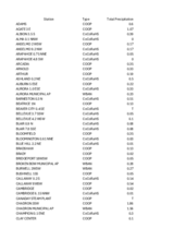
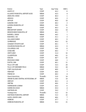
Attached are .pdf's containing the average temperature, growing degree days, and total precipitation for each station that had no missing days over the last week. Includes CoCoRaHS observer reports. Below are the temperature and precipitation extremes around the state over the past week
Maximum High Temperature: 77F, Tekamah Airport
Minimum High Temperature: 36F, Harrison 20 SSE
Minimum Low Temperature: 17F, Bushnell 15S
Maximum Low Temperature: 48F, Omaha Eppley Airfield
Max Precipitation: 3.25", Plainsview Ranch
Max Snowfall: 12.0", Harrison 0.2 NE
Eric Hunt, University of Nebraska Extension


