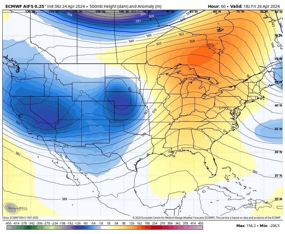
A Tale of Two Troughs
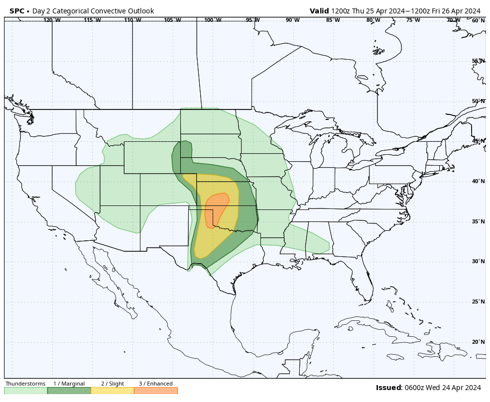
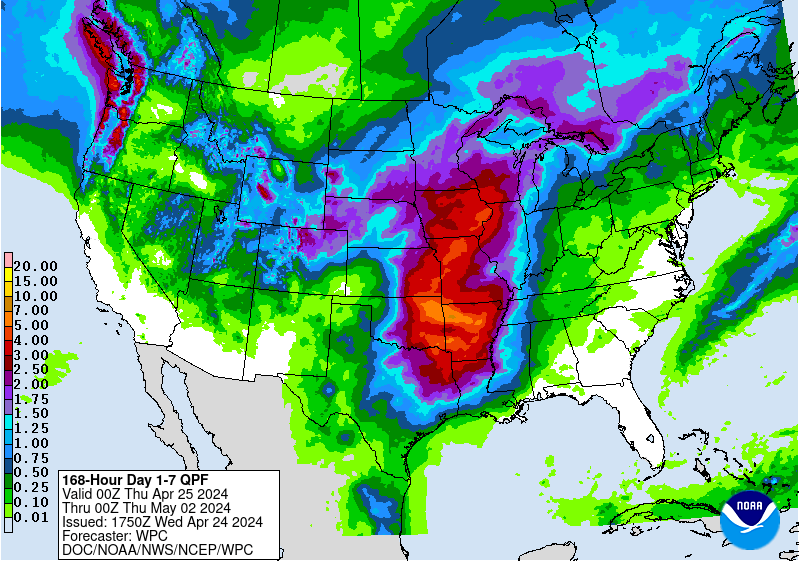
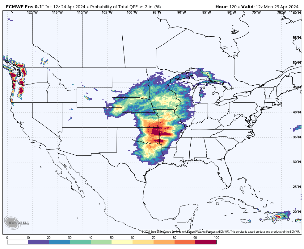
The big question in the next week is not whether we see precipitation across the state but how much as we move into an active period. Over the next several days, we will be visited by two different troughs coming in from the southwest. The first trough will be making its way into the central Plains during the day on Friday while the second trough will be coming in Saturday night through Sunday. Both will be tapping into moisture and instability to produce widespread showers and storms across the state. The first round may begin as early as tomorrow morning across far southern Nebraska though heaviest precipitation is likely to remain in Kansas. Showers and storms will increase in coverage statewide Thursday night with rain lingering into the day on Friday in much of western Nebraska. The SPC does have portions of southwestern and south central Nebraska in the slight risk category for severe storms tomorrow and the eastern 1/6 of the state is in a slight risk on Friday. The risk on Friday afternoon and evening may be higher or lower depending on what happens in eastern NE earlier in the day. If there is sufficient clearing, there may be an enhanced risk of severe storms in places like Pawnee City, Nebraska City, Omaha, and Macy. There will be a chance of 1" rain everywhere in the state between Thursday and Friday but highest chances appear to be across the Panhandle and across northeastern Nebraska. Best chance of not picking up a half inch currently between Thursday and Friday looks to be between Lincoln and Auburn.
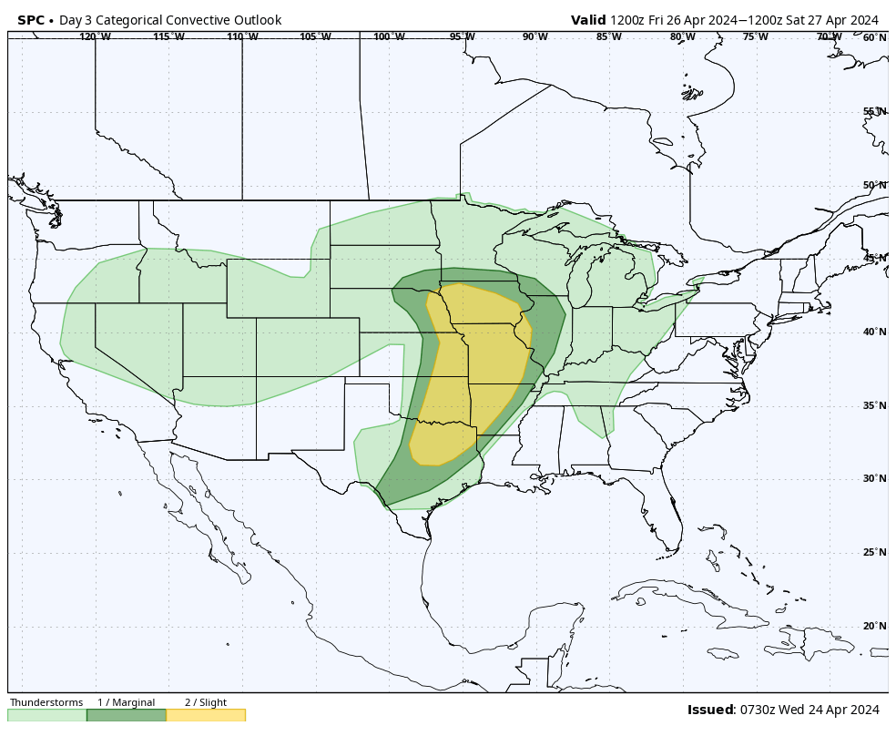
There will be ~24 hour break in precipitation so Saturday currently looks dry and the state will be split by a near-stationary frontal boundary. On the warm side in eastern and south central NE, temperatures are likely to be well into the 70's, possibly climbing up to 82-85 along and south of I-80 in eastern NE. On the cool side expect temperatures to hold in the 50's and low 60's with upper 40's more likely up around Harrison. If that boundary ends up being a bit further east or west, your Saturday high temperatures will look much different than what is currently projected. By Saturday evening the second trough will be making its way into our area, bringing additional showers and storms, with severe storms possible in southeast Nebraska. Heavy rainfall may be possible across the southeastern quadrant of the state on Saturday night into Sunday morning. So places that don't get as much Thursday night into Friday night have a shot at getting more, perhaps a lot more, on Saturday night into Sunday. Sunday also looks a good bit cooler than Saturday in the eastern half of the state as we will be on the cool side of the storm by mid-morning. There is a slight chance precipitation could fall as snow in the Panhandle into the northern Sand Hills on Sunday morning but no major accumulations are expected at this time.
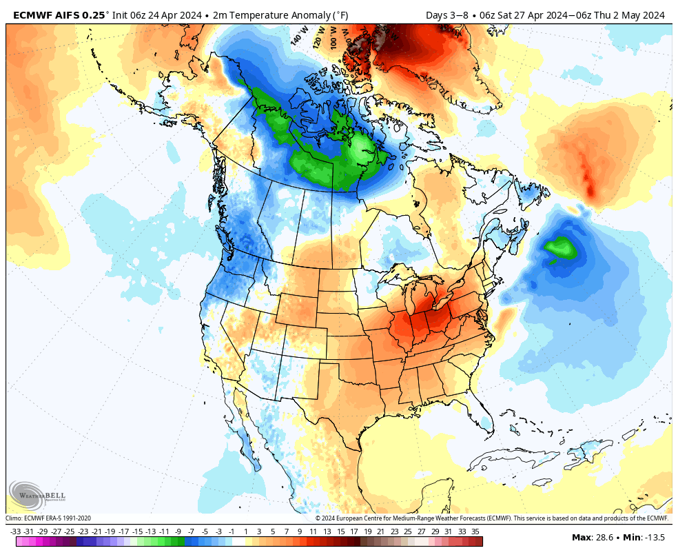
The start of the work week looks dry with seasonal temperatures in the east and a return to warmer temperatures in western NE. Temperatures look to bounce back to the 70's statewide by Tuesday and possibly in the upper 70's to mid 80's by next Wednesday. Another potent storm system may be paying us a visit just in time for the following weekend bringing additional chances for rain. But that is a little ways out.
Moisture and Temperature Update
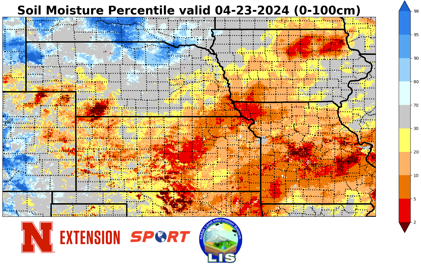
Last Wednesday night, the southeastern corner of state saw showers and storms develop off a near-stationary boundary and some areas picked up beneficial rain. Amounts over an inch were reported in Richardson County. Around that same time, a shortwave brought moisture to north central and northeastern Nebraska, mostly between 0.25-0.50". Additional storms developed over far southeastern Nebraska on Monday evening but amounts were generally under a quarter inch. In parts of the Panhandle and far southwestern Nebraska, light snow fell last Saturday but amounts were light. A quick look at soil moisture percentiles shows that much of east central, southeastern, and southwestern Nebraska are at or below the 30th percentile for 0-1 meter soil moisture so rainfall in those areas the next 3-4 days would be very welcomed.
With the strong frontal passages late last week, temperatures were below average the last third of last week and were well below average last Saturday in western Nebraska. A couple of sites in Kimball County (where the elevation is over 5000 feet) didn't even manage to get above 30 last Saturday. Almost everyone in the state went below freezing at some point last weekend (congrats to Hebron for avoiding it) and much of north central and western Nebraska saw temperatures dip into the mid 20's. For the southeastern quadrant of the state it is possible, perhaps probable, that it was the last light freeze until next fall.
Crop Update
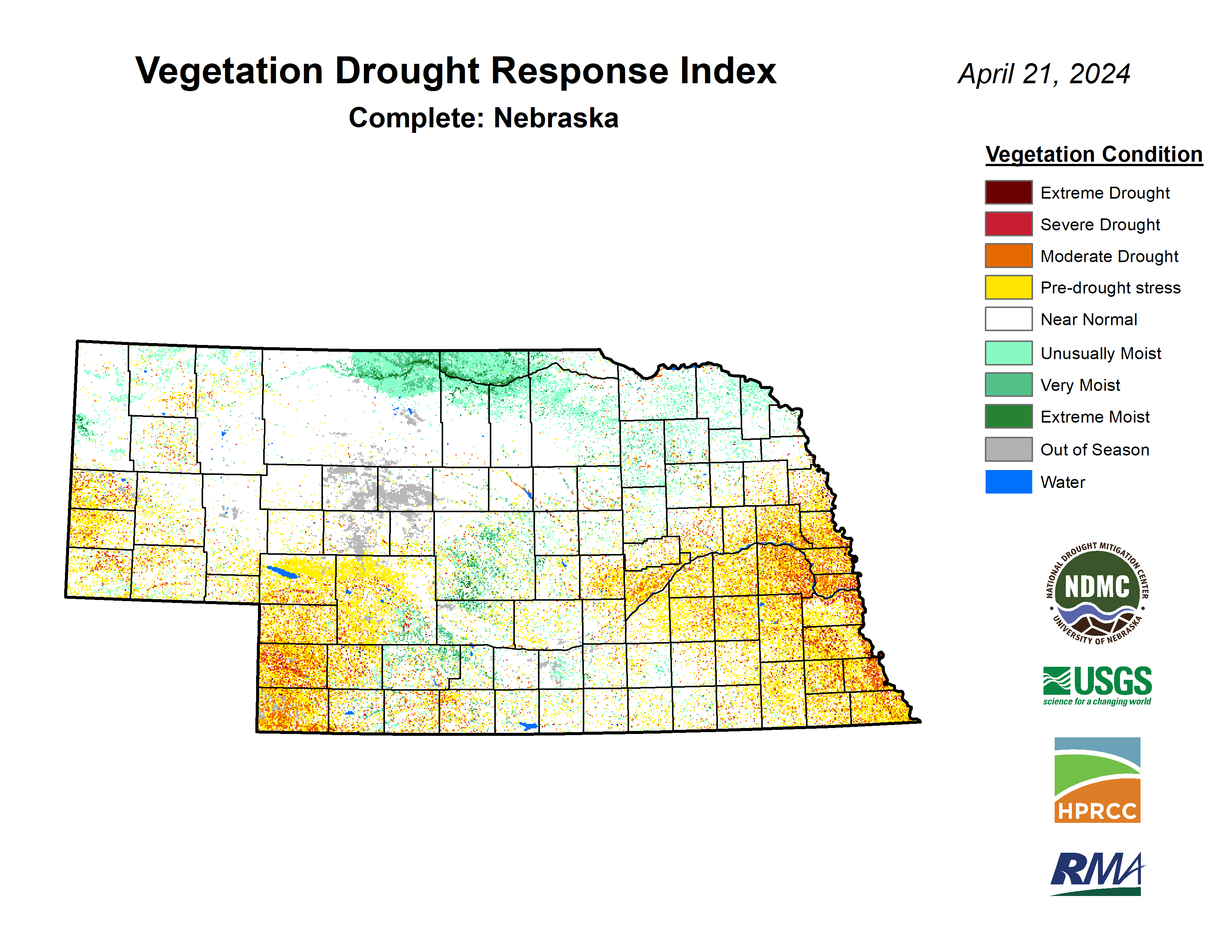
The latest Crop Progress Report shows corn and soybean planting were at 5 and 2 percent respectively at the end of last week, around average for the time of year. It's likely additional planting has occurred since the beginning of the week with the warmer, drier weather. It is also likely that farmers are going to be sidelined for a while starting later tomorrow. Winter wheat checks in at 68 percent good to excellent against 5 percent poor to very poor. Pasture ratings are not available yet (May 1 is often the first reporting date for that) but the VegDRI Rangeland specific map shows that most of the pasture in the state is in reasonable shape for this time of year. Exception being in Dundy and Chase counties where VegDRI indicates moderate levels of stress.
Temperature and Precipitation Roundup
Attached are .pdf's containing the average temperature, growing degree days, and total precipitation for each station that had no missing days over the last week. Includes CoCoRaHS observer reports. Below are the temperature and precipitation extremes around the state over the past week
Maximum High Temperature: 81F, Tekamah Municipal Airport
Minimum High Temperature: 28F, Bushnell 15S
Minimum Low Temperature: 11F, Harrisburg 12WNW
Maximum Low Temperature: 52F, Falls City 4NE
Max Precipitation: 1.59", Shubert 2SW
Max Snowfall: 2.4", Bushnell 15S
Eric Hunt, University of Nebraska Extension


