


Earth, Wind and Fire
It is currently a beautiful day across the state with ample sunshine, mild to warm temperatures , and lighter winds. I recommend enjoying the lighter wind speeds because those will be picking up tomorrow and then will blowing at near gale forces on Saturday, especially in central and eastern Nebraska. The responsible culprit is a surface low that is expected to develop in the lee of the Rockies and move northward into western Nebraska during the day on Saturday. The upper level trough responsible for the surface low will be digging into California and the southwestern U.S. in the next 24 hours and then will eject out into the High Plains on Saturday. With a stronger area of high pressure at the surface off to the northeast in Ontario, the development of the low pressure will mean an increasing pressure gradient and increased wind speeds ahead of the low pressure area. The fire danger won't be as critical as it may have been a month ago under the expected wind speeds thanks to greening grasses (reducing fuel load) and relative humidity levels staying in the 35-45 percent range. Nevertheless with wind gusts from the south-southeast possibly exceeding 50 mph on Saturday in areas east of Ogallala, extreme caution should be heeded with any outdoor burning. Best to save it for early next week. It will not be an ideal day for travel across I-80.
I Wish It Would Rain Down
By Saturday afternoon, a line of showers and thunderstorms is expected to develop across south central Nebraska and extend down into Kansas to the east of the surface low and an area of rain and rain mixed with snow will be developing to the north and west. The showers and storms will then move off to the east and will affect the eastern portion of the state during the evening hours Saturday into early Sunday. At this point the severe risk looks marginal but it will be worth keeping an eye on. If the moisture return is a little better than currently projected, the instability may be sufficient for a more intense line of storms with a damaging wind and hail threat.
On the other back side of the low, a colder rain will be the rule with some chance of measurable snow in the northern part of the Panhandle on Saturday night into Sunday. During the day on Saturday, the low will slowly wander to the ENE through north central and northeastern Nebraska. This will allow additional chances for showers across the state on Sunday, particularly in the northern section of the state. A period of sunshine further to the southeast in east central and southeast Nebraska could help with instability, which may lead to brief downpours with small hail in places like Columbus, Wahoo, Lincoln and Omaha. In any event, almost all of central and eastern Nebraska will get a nice shot of moisture- likely between 0.50-1.00"- between Saturday afternoon and Sunday evening. This may not move the drought needle in a lot of places but it will be needed moisture going into the ground before planting. Total precipitation amounts are likely to be over an inch in the Panhandle with the northern portion of the Sand Hills also expected to get ample moisture in the 0.75-1.50" range as well. The southwest is likely to have the least amount from this system, though places like Imperial and McCook are likely to pick up more moisture than last weekend.
Total Eclipse of the... Sun?
Nebraska is well to the northwest of the path for the total solar eclipse on Monday so the parody of Bonnie Tyler's song doesn't quite fit here. Go to Evansville, IN for that. But the eastern side of the state will be in the 80% solar eclipse range. If the aforementioned area of low pressure moves off to the east by Monday morning, there should be enough clearing for eclipse viewing. But that is certainly no guarantee. Don't be shocked if the clouds hang around for most of the day Monday, especially in the east. Personally I would rather have an eclipse in late July when the sun taking an hour lunch break would be welcomed.
Mostly Quiet week
After the storm system starts exits to our east on Monday, we will be entering a period more dominated by mid and upper level ridging. That will help keep temperatures seasonal to mild and precipitation chances lower for much of the week ahead. Our region is expected to be well to the north of a slow moving trough, which will bring generous precipitation to the Southern Plains (which is needed). But a bit of a northward shift would mean chances for rain across the southern and eastern portions of the state on Wednesday into Thursday. Temperatures should be mostly seasonal across the state in the upcoming week with better chances for temperatures exceeding the 70F threshold by next weekend.
Early Planting Window?
The current outlook is trending toward favoring an early planting window in the core production areas of the state with drier conditions likely most of next week into the week of the 15th. It also is expected to be relatively warm during much of the period from the 14th-19th. 4" bare soil temperatures are currently in the mid 40's across most of the state and with warmer weather expected heading into mid-April, soil temperatures should easily exceed 50F by the 15th. At this point it is too early to rule out a decent freeze in the last part of April or early May in south central and eastern sections of the state. But there is also no clear signal for a significant cold spell coming into our region of the country later this month either.
Soil, Recent Precipitation, and Drought Update
Soil temperatures are generally in the 40's across the state, with upper 40's being more common in southeast NE, mid 40's across Central, South Central, and Panhandle sections of NE, and lower 40's in North Central and Northeast Nebraska. Soil temperatures are already over 50F in the southwestern corner of the state where it has been warmer and drier of late. Soil moisture percentiles are generally in the near normal range across the state. Exceptions on the high percentiles side are north central and northwestern areas where more robust precipitation fell last weekend and early this week. On the low percentiles side would be southwest NE and southeast NE. There is also some creeping dryness showing up in parts of east central Nebraska over the last week with the lack of moisture and windier conditions.
Precipitation amounts exceeded an inch late last week over parts of the Panhandle and the northern Sand Hills with a broad area of western and northern Nebraska picking up a half inch of moisture. Areas of the state with long-term drought conditions or residual abnormal dryness generally received under a quarter inch over the previous week (many places had less than 0.05"), which was not enough to move the needle, especially now that we are entering a wetter time of year. In more plain terms, our weeks will need to be wetter in an absolute sense going forward to get the drought improvement that is needed and desired.
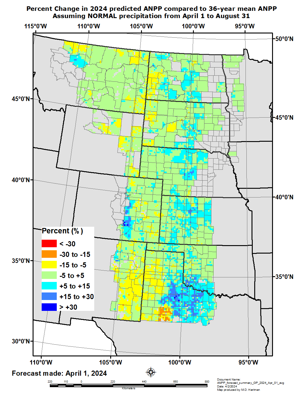
Winter Wheat Update and GrassCast Outlook
The latest NASS Crop Progress Report shows 65 percent of winter wheat in the state in the good to excellent (G-E) category against just 5 percent in the poor to very poor category (P-VP). This is the best shape winter wheat has been in based on a statewide average since 2020. The first GrassCast maps of forage production potential for 2024 were released earlier in the week. The good news is that forage production is expected to be near or above normal in western Nebraska this coming season even under just a normal rainfall scenario.
Eric Hunt, University of Nebraska Extension