Storms possible this evening and tomorrow
The SPC has much of eastern Nebraska in a slight risk for severe storms later this afternoon and evening. Biggest threats would be hail and localized flooding from heavy rainfall, especially in the Omaha metro where several inches of rain have fallen already this week. There is some disagreement in the models on how far west storms will develop but the farther east one goes, the better the chances are of seeing storms. Storm development is most likely after 6:00 this evening and the greatest threat is between 7PM and midnight. Another shortwave will be moving into the northern part of the state tomorrow, which will bring a shot of additional showers and storms to north central, northeast, and east central sections of the state tomorrow evening. Severe risk is more marginal tomorrow but small hail and gusty winds can't be ruled out.
I wish it would rain down
The general synoptic pattern over the next week will feature an amplified pattern with troughing off the Pacific Northwest, ridging across the southwestern U.S., and a trough over the Great Lakes. That pattern will keep Nebraska under west-northwest flow for much of the week. Embedded shortwaves in that flow will help bring chances for showers and storms at various points in time over the next week. At the moment, there appears to be a good chance for showers and thunderstorms across central Nebraska on Saturday night, with a chance they make their way over toward Norfolk, Columbus, and Seward. Chances for storms Sunday and Monday are highest across western sections of the state, across the central and eastern sections of the state on Tuesday night and across eastern Nebraska on Friday. Some areas could stand to pick up additional beneficial precipitation next week but after Friday, things may be pretty dry across the state for the following 5-7 days as the ridge builds north and east.
Seasonal temperatures. But heat is coming
Temperatures next week will be seasonal- highs mostly in the 80's and possibly low 90's by Saturday, though any lingering convection or cloud cover could keep temperatures down in the 70's. Temperatures will generally be a bit cooler earlier in the week than later in the week, especially in eastern NE where an early week cold front will bring in another shot of cooler and slightly drier air to start to the week. Overnight lows are likely to be elevated in the second half of the week as it will be humid. All in all, nothing too atypical for August, but the warm low temperatures should lead to next week being a bit over climatological norms overall for most of the state. The real heat may be coming the week after next as the ECMWF AI is suggesting chances for that southern ridge to build north and bring a few days of intense heat to the Central Plains and Western Corn Belt. Triple digit heat may not be done with areas of western and southern Nebraska just yet. The CPC is in agreement with it being above average in the 8-14 day period and the worst of the heat is possibly just beyond that.
Beneficial moisture
The past week has been generous to much of the southern Panhandle and southwestern NE where most places have received over an inch and several locations have picked up over 2". Not all of this soaked in (perhaps not even a majority in some cases) but it was still very welcomed moisture in an area that had been pretty dry over the previous several weeks. The Highway 30 corridor from Columbus to the Omaha metro area also picked up 1.5-4" of rain over the past several days, with some locations in Sarpy County closing in on 5" since Sunday evening. Other areas in eastern Nebraska picked up between half an inch and inch between Sunday night and last night. Exception is parts of southeast Nebraska (e.g., around Beatrice) where some locations had less than a tenth of an inch and are seeing rainfall deficits start to accumulate again. The Highway 136 corridor between Fairbury and Johnson is an area to watch for flash drought if rain doesn't materialize soon.
Coolest August week on record
After a very warm start to the month with record heat in the Panhandle, temperatures dropped sharply in central and eastern NE last Tuesday and then later in the week in western NE. In fact, the previous seven days featured the coolest average temperature for the common period on record (Aug. 7-13) for the central, south central, east central, and southeast climate divisions. Temperatures were especially cool across the state last Friday with some areas in the western Panhandle not getting out of the 50's and much of central NE spending the weekend socked in with clouds and maximum temperatures in the 60's. Overnight lows dipped into the upper 40's and low 50's last Friday morning and into the mid 50's on Saturday and Sunday mornings in the eastern side of the state. Combined with maximum temperatures staying in the low to mid 70's for several days, average temperatures were in the mid 60's for several days. The cooler weather has set heat unit accumulation back and parts of central and northeast NE are getting close to being behind the curve on GDD's or heat units. This isn't necessarily a cause for concern though given the heat that is likely to be present later in the month.
Temperature and Precipitation Summaries
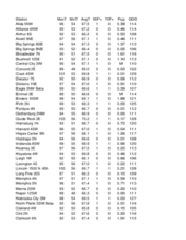
Attached are pdf's containing the maximum/minimum temperature, average temperature, number of days with maximum temperatures ≥95F, minimum temperatures ≥70F, degree days, and total precipitation for each Mesonet station over the period from August 4-August 10. /p>
Below are the temperature and precipitation extremes around the state over the past week:
Maximum Daily High Temperature: 96, Scottsbluff 1E
Minimum Daily High Temperature: 54, Bushnell 15S
Minimum Daily Low Temperature: 45, Springview 2 NW
Maximum Daily Low Temperature: 67, Falls City Brenner Field
Maximum Weekly Precipitation: 2.99, Champion 2.6 SW
Minimum Precipitation: 0.00, Multiple Locations
Eric Hunt, University of Nebraska Extension


