High Fire Danger Saturday and Sunday
Precipitation is moving out of the state and clouds are starting to clear across the northern portion of the state. The next several days will be dry but there will be some up and downs in temperature and it will also be rather windy over the weekend as a cold front moves through. Relative humidity values will also be low as dewpoints drop into the teens statewide. The combination of wind, mostly dormant vegetation, and lower relative humidity means that fire danger will be high statewide. It will be particularly high in northeast Nebraska where there has been the least amount of recent precipitation. Please be careful both days.
The Lamb
Monday through Wednesday looks beautiful with ample sunshine, mild temperatures in the 60's to low 70's statewide, and a bit of a breeze. I recommend enjoying it.
The Lion?
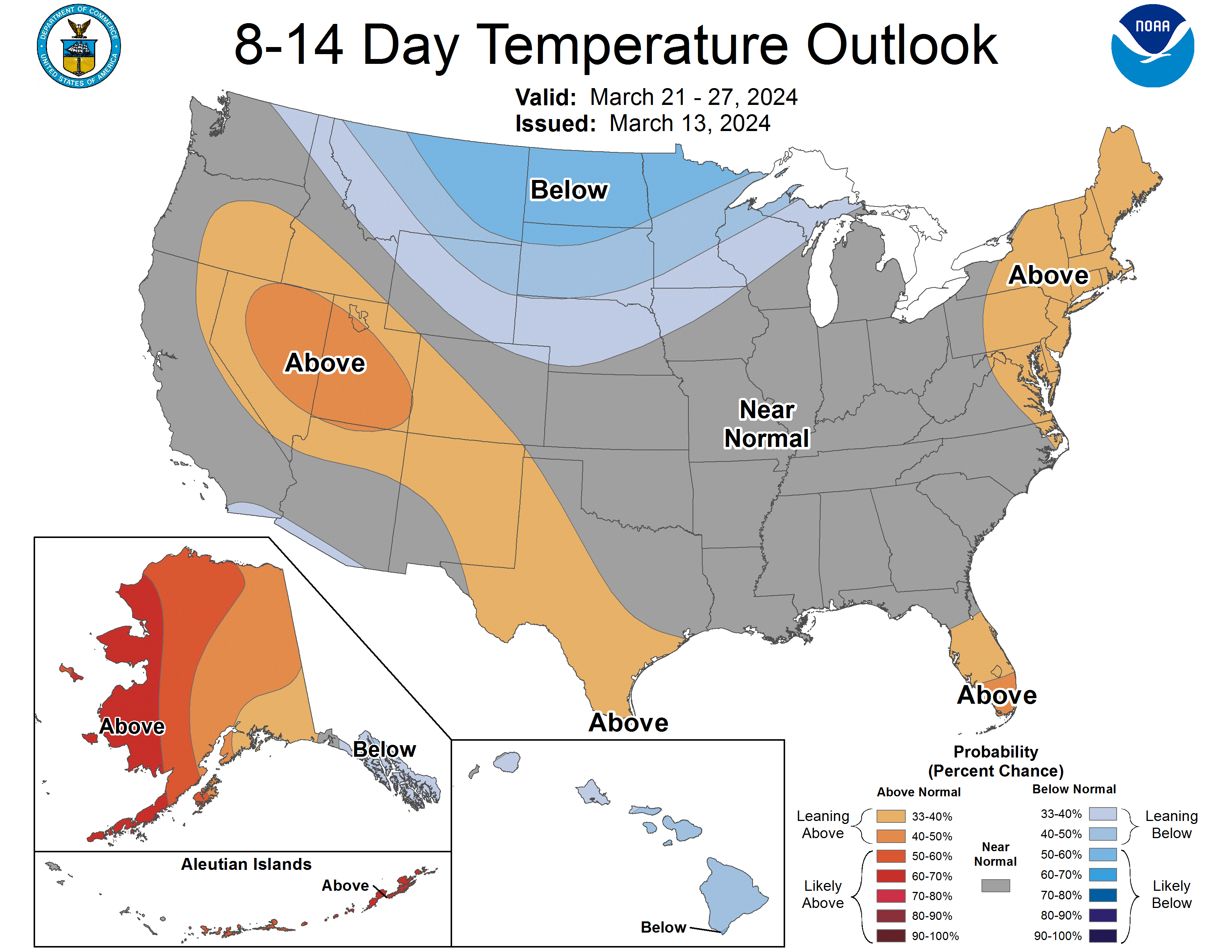
Things will begin to change later in the week. A shortwave will move into the region early Thursday bringing a chance of showers and storms to the southern portion of the state. Severe risk looks low at the moment but may be worth monitoring more carefully as time gets closer. By the end of the work week, a sharp trough will be entering the western U.S. and a strong cold front will be starting its journey through the state. After the front passes through, temperatures will be considerably colder and possibly cold enough to allow for precipitation to fall as snow.
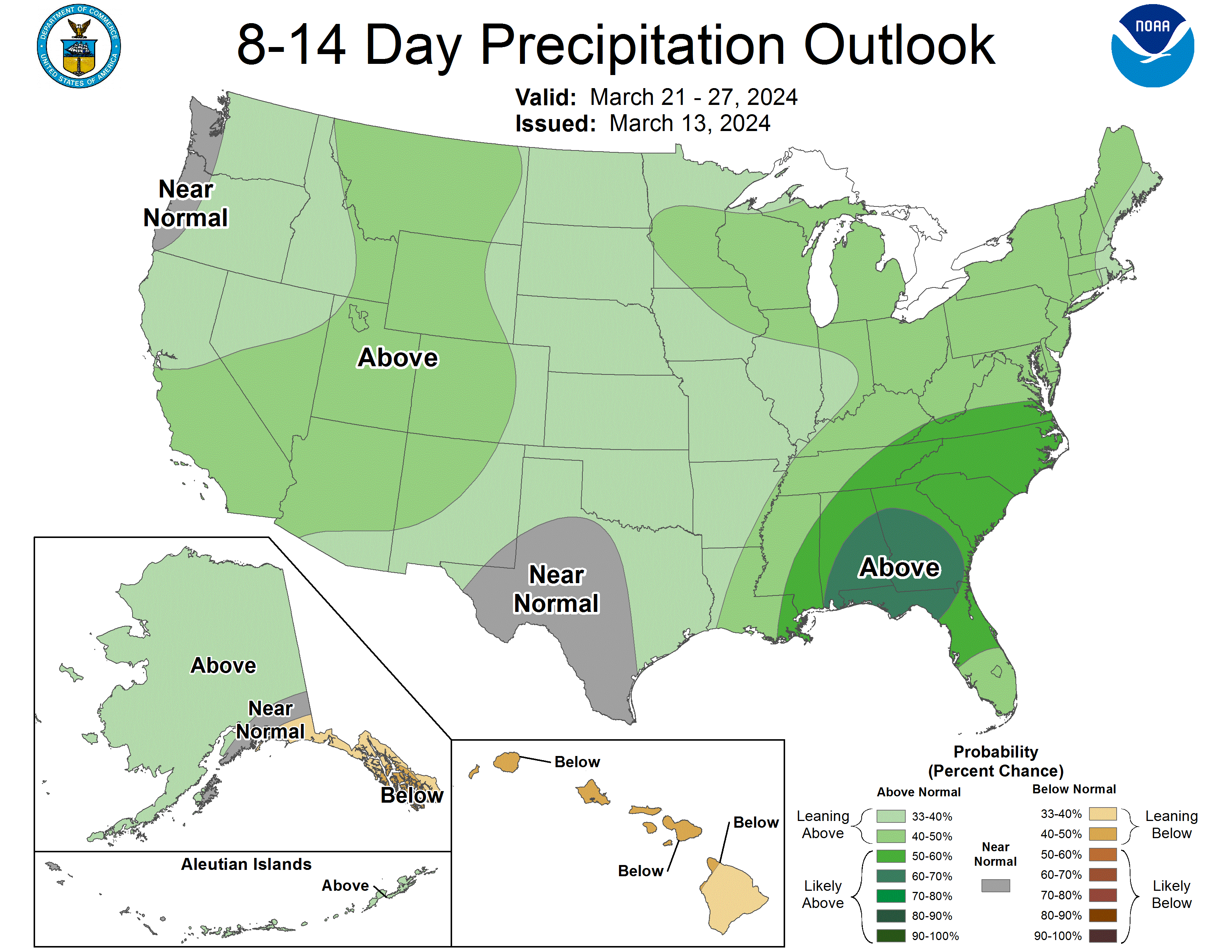
I bring snow up because we will need to watch what develops later next week into the week of the 24th. Right now there is signal in the models for an area of low pressure to develop on the eastern side (lee) of the Rockies and move into the Plains by next weekend. Depending on the strength and track of the system(s), some areas in Nebraska could be in for a lot of rain, a lot of snow, or some mix. Right now the track would favor precipitation across the state but keep the bulk of it east of North Platte and southeast of Burwell. Right now it is too early to pin down exact amounts of precipitation or snowfall amounts or the exact timing. But this could be a system that produces around an inch of moisture in the south central section of Nebraska and over 1.5" in eastern Nebraska between next Saturday and the 25th. There is also historical precedent for heavy snowfall in central and eastern Nebraska in the back half of March in years following a very mild winter (1987 and 2006 are good examples). Best advice for now is to prepare for the possibility of impactful weather next weekend and pay attention to the forecast to see how things evolve.
Moisture Update
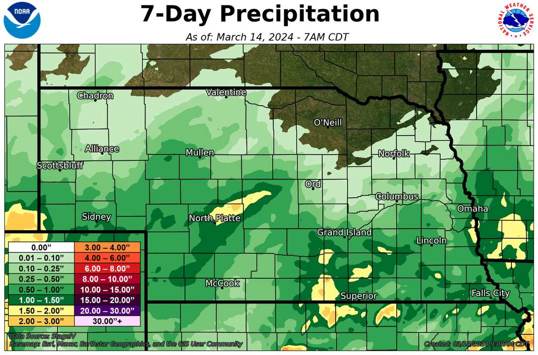
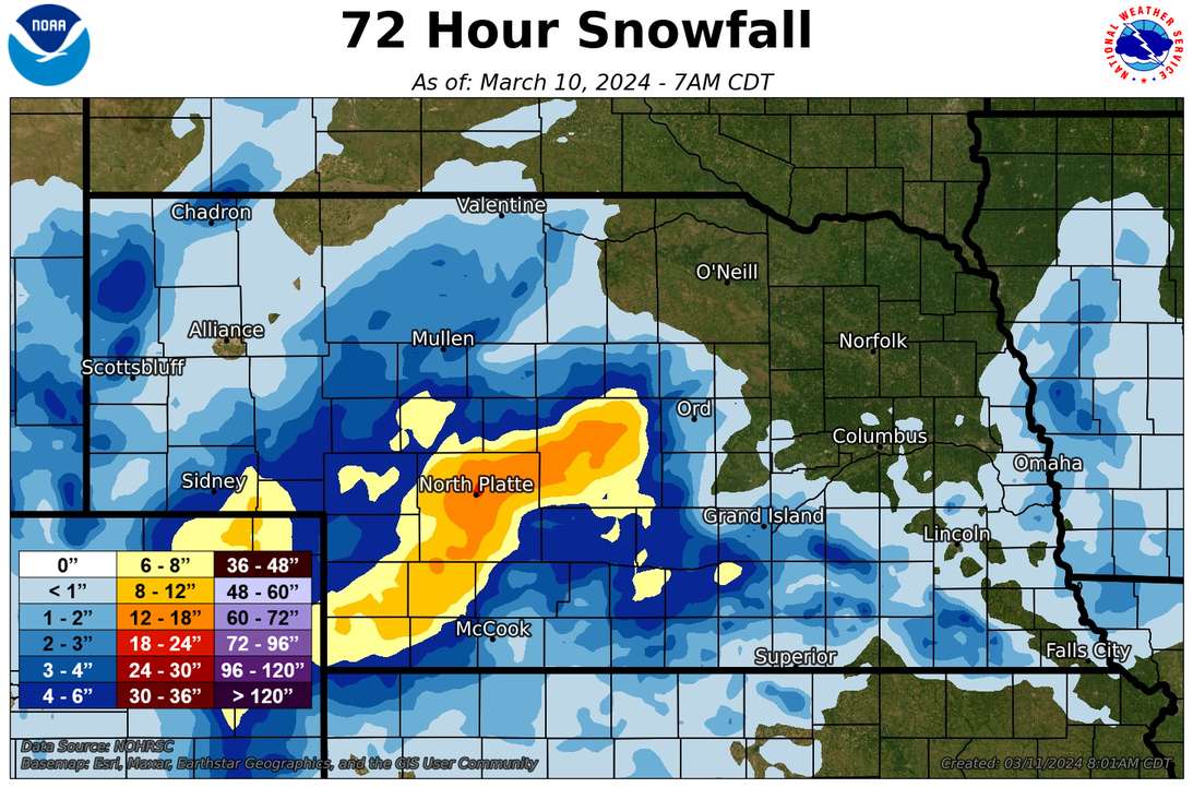
For the first time in several weeks, most of the state received meaningful precipitation over the past seven days. For western Nebraska, this came in the form of snow and lots of it in some cases last Thursday. Large sections of Lincoln and Custer counties received over a foot of snow and a couple of CoCoRaHS observers in North Platte reported almost 20". Further east there was a mix of rain and snow last Thursday night into Friday morning. For parts of east central and southeastern Nebraska, it was the first precipitation of any consequence in a month. Unfortunately most of northeastern Nebraska missed out on the precipitation.
The next round of precipitation came in late last night and this morning compliments of a warm front and surface low that has moved into Iowa. Heaviest precipitation fell over the southeastern quadrant of Nebraska, where some locations have picked up over an inch and amounts of 0.5-0.75" are common. Unfortunately for the northeastern section of the state, precipitation was marginal- generally under a tenth of an inch.
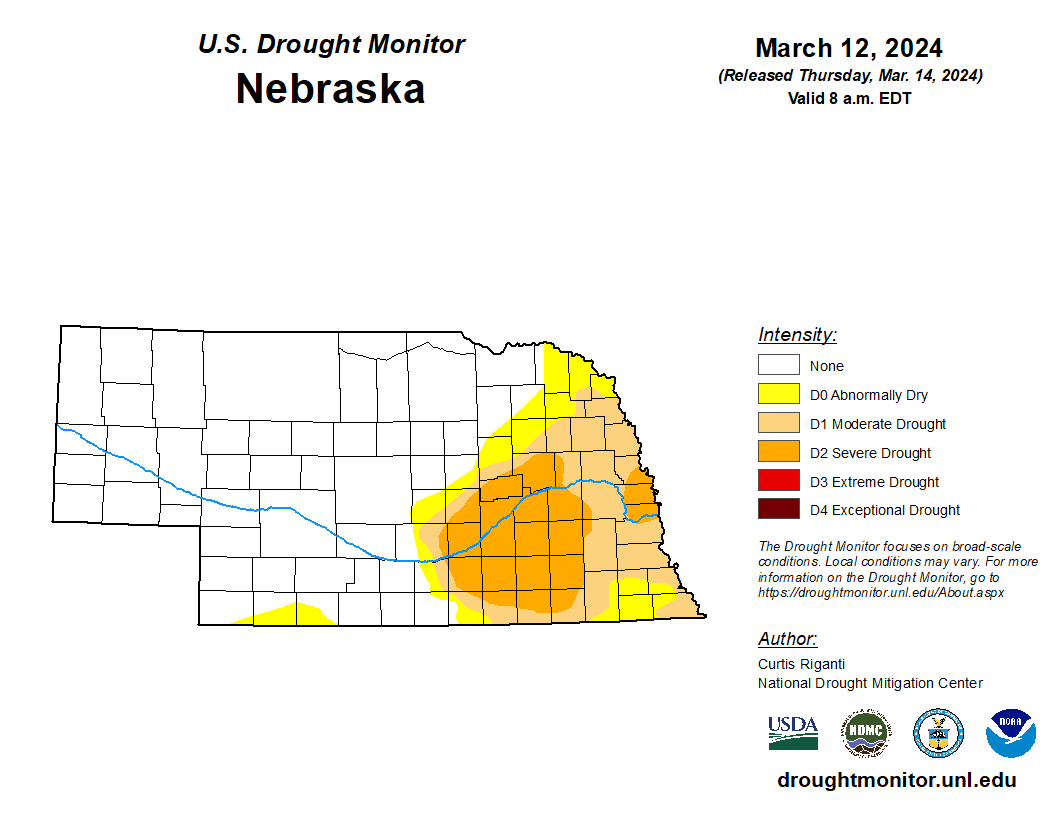
Drought Update
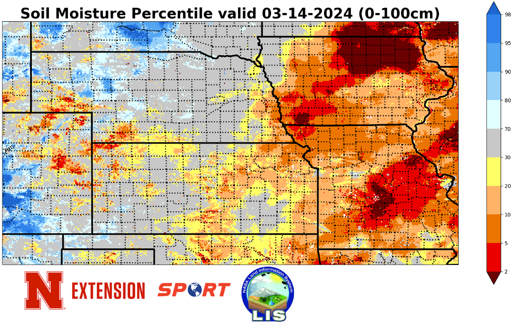
The lack of precipitation over the past 45 days led to the introduction of abnormal dryness (D0) across northeastern Nebraska from Albion to Hartington. This area is still in much better shape than a year ago but some of the soil moisture gains from fall and the first half of the winter are starting to go away, particularly in the top-soil. One good storm could correct most of the recent dryness but that moisture is necessary soon. There was good news on the drought front though. The precipitation last week was sufficient enough to lead to removal of D0 in parts of eight counties in the southwestern corner of the state. In aggregate, there was a decrease in the percent of the state in abnormal dryness or drought, which now stands at 31 percent and the lowest since June 2020.
Near-record warm February and winter
February came in as the second warmest on record statewide and was the warmest in the eastern crop reporting districts. For the winter as a whole, it was the fifth warmest statewide. Only catching the brunt of the the polar vortex stretching in mid-January kept it from being the warmest winter on record.
Eric Hunt, University of Nebraska Extension