Happy Fall
Meteorological fall started this past Sunday and for the eastern half of the state, it actually felt more like fall earlier in the week. A cold front has pushed through the state over the past 24 hours, bringing much needed relief from the heat and a few scattered showers western Nebraska yesterday and is currently bringing a few scattered showers to central and eastern Nebraska. A peak at rainfall totals today at Mesonet sites shows that precipitation amounts have been generally under 0.05". Any precipitation that manages to fall later today in eastern Nebraska likely won't do anything than tease plants and spot up your windshield. Just isn't any decent moisture return at the moment.
An additional shot of cooler air will be arriving tomorrow morning for the eastern two-thirds of the state. High temperatures likely will be in the 70's (possibly upper 60's in northeast NE) the next few days with lows getting into the 40's over much of northern and eastern Nebraska on Saturday morning. A few spots in northeast and east central sections of Nebraska may dip into the upper 30's briefly. Frost is not expected. Temperatures will be cool on Sunday morning as well in eastern Nebraska but high temperatures will be back to average levels in the lower 80's. Over the western and north central section of the state, temperatures will be well into the 80's by Sunday afternoon.
Football forecast
Weather for the football game on Saturday evening looks ideal with a large area of surface high pressure off to our east. Afternoon highs in Lincoln should be in the low to mid 70's and kickoff temperatures should be around 68. Winds will be light from the southeast. Our forecast for the game itself:
Eric's prediction: Nebraska 31 Colorado 21
Camille's prediction: Nebraska 38 Colorado 20
It never rains... in Nebraska?
A large ridge will be in place over the north central section of the continent next week with troughing off both coasts and the possibility for some tropical development in the Bay of Campeche. While the latter will be worth watching for southeast Texas and Louisiana, there is currently just a slight chance it makes a trip due north and gives the eastern side of the state some rain. What we are most likely going to get is a warm, breezy week with temperatures generally running 7-14F above average for the second week of September. Thus, expect temperatures well into the 80's across northeast Nebraska, lower 90's for southeastern and central Nebraska, and mid to upper 90's for the western third of the state for much of the week. Good chance of 100-102 again around Chadron on Monday and Tuesday. Temperatures should cool off a little statewide later in the week, especially if there is more cloud cover or precipitation than what is currently projected. Humidity values will be lower, especially earlier in the week, so heat advisories are not expected.
There will be a chance of showers and thunderstorms next Friday night into Saturday, especially across western and central sections of Nebraska. But I'd like to see more agreement in the models on the placement of shortwave energy in the western U.S. that would help bring that possibility of needed rainfall to fruition. Same with whatever develops in the Bay of Campeche/Gulf of Mexico next week as that would have a potential to bring southeast Nebraska some moisture. Right now my confidence is rather low that most places in the state receive any meaningful precipitation over the next 7-10 days. Furthermore, there is some possibility that some areas of eastern NE may not have measurable rainfall for the month of September until after astronomical fall sets in on the 22nd. Not necessarily my official forecast- just a worst case scenario given the upper air pattern that may be "stuck" for a spell.
Worsening conditions
If we had been super wet the past month, the current forecast of warm and dry would be a blessing. Unfortunately, many locations outside of the southern Panhandle, southwestern Nebraska, and isolated pockets in eastern Nebraska have been dry to very dry over the past several weeks. Thus, drought is increasingly becoming a concern. The latest Drought Monitor shows that over a quarter of the state is now in drought (up from 1 percent three months ago) and an additional 40 percent of the state is in abnormal dryness. D0 (abnormal dryness) isn't quite drought but it is a warning that it is coming unless it gets wet again. The best thing I could say at this point is that we are lucky that this is a late season onset of dryness and drought as the impacts to this season's crops will be more modest than if it had started a month earlier. The warmer, drier conditions may also allow for an earlier harvest of rainfed crops that have started maturing. That's my positive take on something that is not going in the right direction overall.
If we remain warm and dry deep into September, there is a very good chance that we will see over half of the state in drought by the time we get into October. There is, of course, some possibility we start getting more robust precipitation later in the month and the drought concern abates for a while. But given the bullishness of models on the likelihood of remaining in the current upper air configuration for the next few weeks (and possibly beyond that) and recent precedent for dry Septembers, there is a real possibility we see drought become a bigger problem as we head into the fall. A look at the change in soil moisture percentiles, while not a literal accurate reflection, does show how much the Central Plains and Western Corn Belt have dried out over the past several weeks. The lack of top soil and deeper moisture will lead to more challenges for wheat and cover crop establishment and it will also lead to increasing risks of wildfire as we move deeper into fall. We're better off moisture wise than at this time in 2022 for most places but that gap is narrowing.
Temperature and Precipitation Summaries
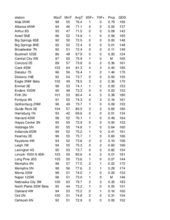
Attached are pdf's containing the maximum/minimum temperature, average temperature, number of days with maximum temperatures ≥95F, minimum temperatures ≥70F, degree days, and total precipitation for each Mesonet station over the period from August 25-August 31.
Below are the temperature and precipitation extremes around the state over the past week:
Maximum Daily High Temperature: 102F, Chadron
Minimum Daily High Temperature: 73F, Culbertson
Minimum Daily Low Temperature: 34F, Harrison
Maximum Daily Low Temperature: 71F, Falls City
Maximum Weekly Precipitation: 3.66", Wakefield 3NW
Minimum Weekly Precipitation: 0.00", Multiple Locations
Eric Hunt, University of Nebraska Extension
Camille Shifrin, Nebraska State Climate Office


