

Drought Update
Mostly good news to report this week. The percentage of the state in drought is down to 66 percent. While this is still high, this is a significant decline from three months ago when that number was closer to 99 percent. Even better news is that over 20 percent and a majority of the panhandle is free of drought and abnormal dryness. Further east there was additional improvement as well. While portions of eastern and central Nebraska unfortunately remain in exceptional drought (D4), there was a 1-category improvement to extreme drought (D3) in places such as Norfolk, Columbus, David City, and Seward. Further southeast, much of Lancaster (and all of Lincoln) has seen an upgrade to severe drought. This area has done particularly well with rain over the past two weeks, with upwards of 6” in many places. The long-term deficits are still acute but the short-term indicators in this area are now positive for the first time in at least a year. Recent precipitation has also taken much of Richardson, Pawnee and Nemaha counties out of drought after a relatively short stay in moderate drought (D1).
There was some degradation to report this week. The southern portions of Thayer and Nuckolls counties have mostly missed the recent rains and saw a downgrade to extreme drought. There was also some degradation to extreme drought introduced into parts of Cass County. But this area was in extreme drought on the last map in June, saw improvement to severe drought on last week’s map and went back to extreme drought. So that degradation is probably best viewed as a technicality of author interpretation. Regardless drought absolutely still exists in that area, as it does over almost all of central and eastern Nebraska and there is still a long way to go before it’s over.
Precipitation Update
Precipitation was generally less robust over the state over the last week compared to the previous week. Nevertheless, most places received precipitation and most of the Highway 81 corridor between Stromsburg and the Missouri River picked up over 2” of rain, which helped bring much of the area out of exceptional drought. Heaviest precipitation over the last week was found in southern Antelope County, with a CoCoRaHS observer reporting almost 4.5” in Elgin. Much of the Omaha area picked up over 2” in the past week.
Vegetation and Crop Condition Update
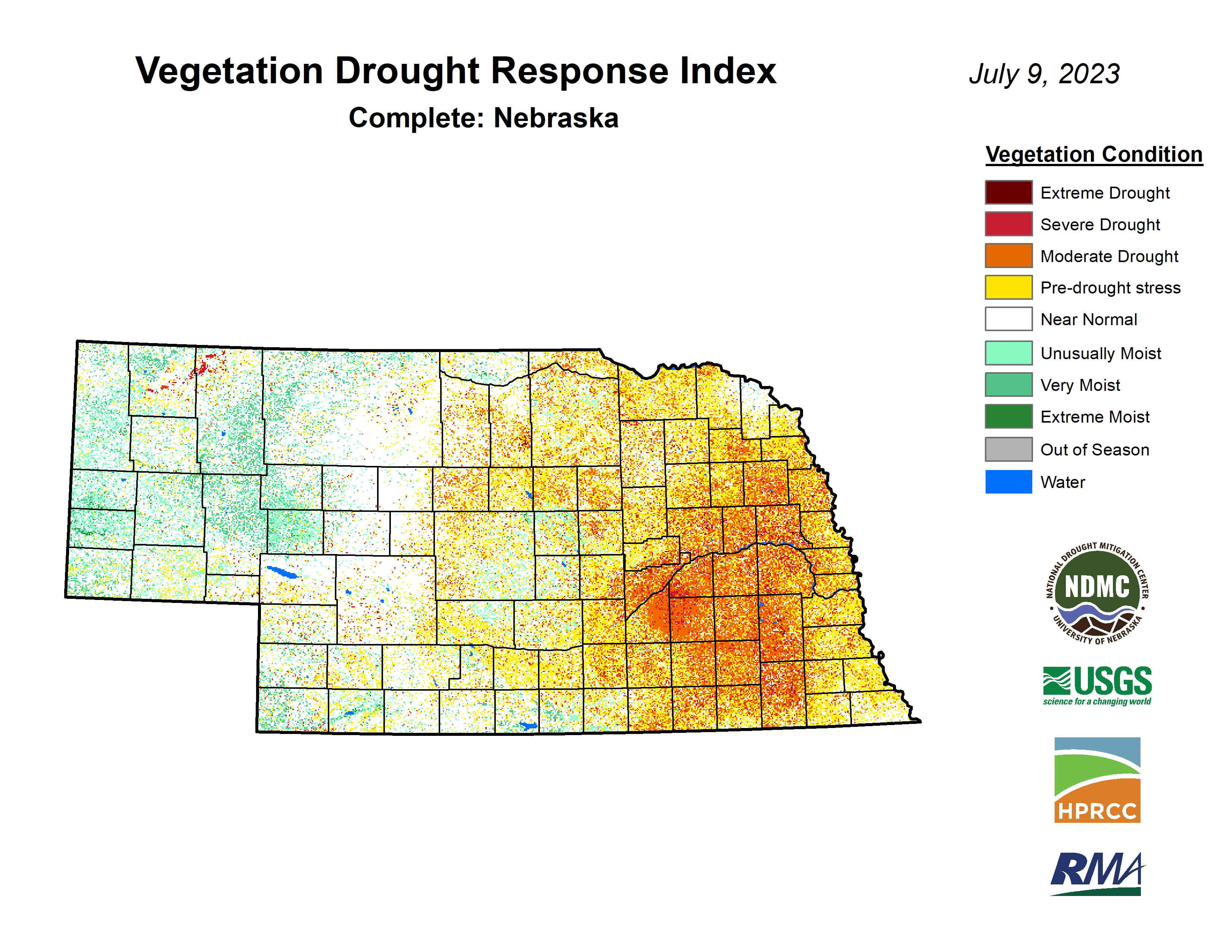
The latest VegDRI map continues to be in good agreement with the U.S. Drought Monitor map, which shows the worst conditions in the area between Aurora and Seward and down into Saline County. Hopefully the recent rains will help rainfed crops have a chance at a decent season but it’s likely that it was too late for some of the rainfed crops. It will be interesting to see how quickly pastures recover over eastern Nebraska in the coming weeks if rain continues.
Pastures continue to improve slowly and the percentage of pasture statewide in poor to very poor condition is at 14%, lowest in several months. Better news still is that over half of statewide pasture is in good to excellent condition. Expect that number to improve if rain continues to fall in eastern Nebraska. Corn and soybean came in at 15% and 19% poor-very poor respectively on the latest NASS update. Those numbers are slightly better than last week’s report and while poor for this time of year, it is considerably better than at the same point in 2002 or 2012. There are likely fields that aren’t going to produce much this year due to the acute dryness through late June, particularly in the area around York, but there is definitely potential on rainfed crops further east in Nebraska.
Corn has started getting into the reproductive stage with 21 percent at silking. This is a bit above the 5-year average of 15 percent. About half of soybean in the state is considered to be in the blooming stage and a small percentage (3%) are setting pods. Sorghum is starting to head and is in reasonably good shape with 67 percent considered good-excellent. The wetter conditions over the past two weeks have hampered an accelerated wheat harvest, with only 12 percent harvested as of now. This is over 20 points behind last year at this time. In discussions with fellow Extension Educator Nathan Mueller, there are some truly awful wheat yields in the worst affected drought areas of Saline, Gage, and Jefferson counties. Expect most wheat yields in the eastern half of Nebraska will be quite low this year.
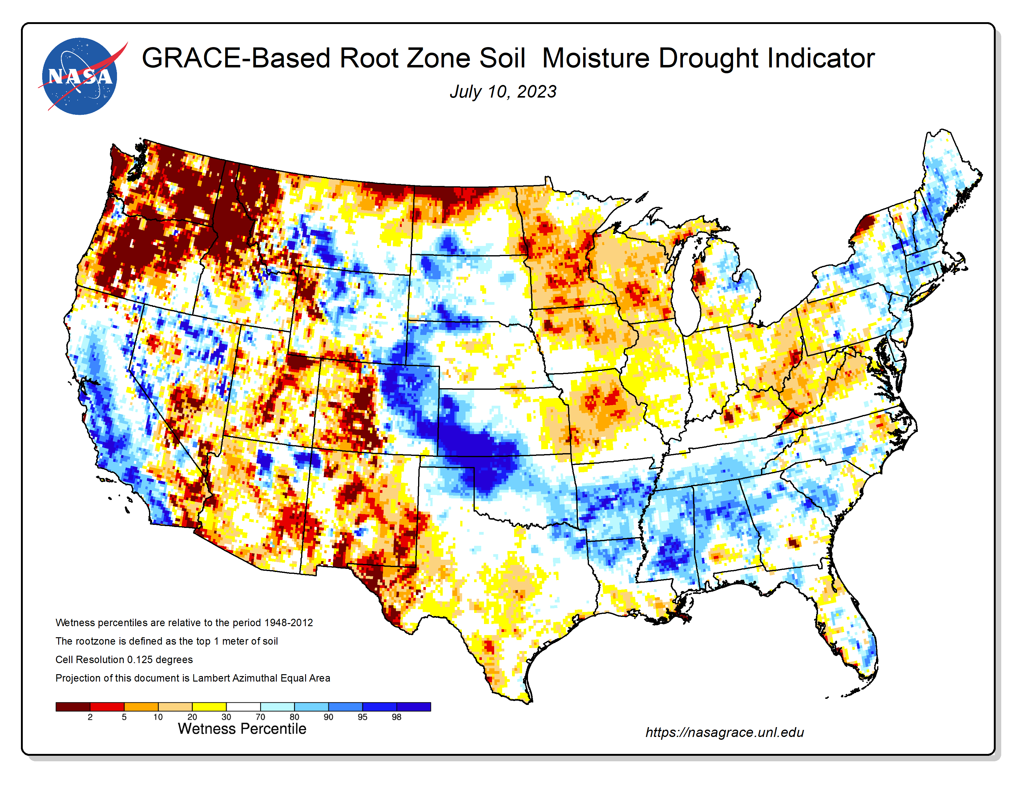
The good news is that many areas now probably have a bit of reserve moisture to help the corn and soybean crops through pollination and pod setting. According to the latest GRACE-based soil moisture map, the top meter of soil in much of the state is about typical for this time year. This map may not be literally true everywhere but it is a good reflection that there is considerably more soil moisture now compared to three weeks ago. We can confirm a good improvement in soil moisture at the Mesonet sites in eastern NE.
Eric Hunt, University of Nebraska Extension and Nebraska State Climate Office