
Drought Monitor Update
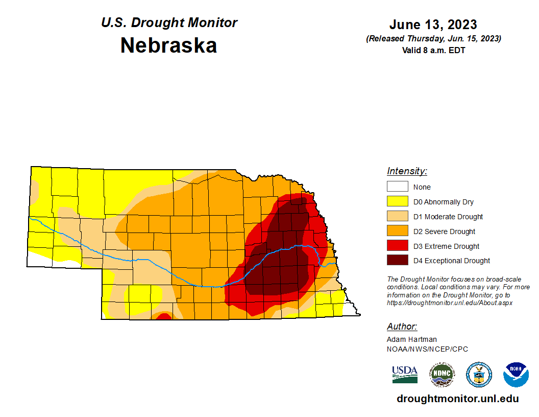
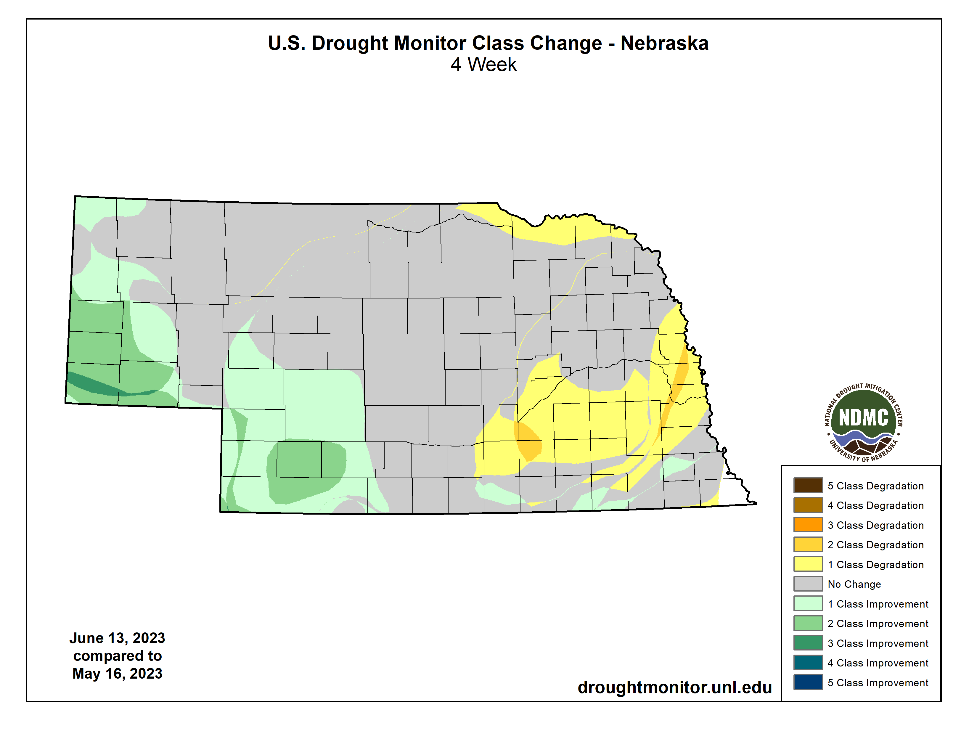
Roughly one quarter of Nebraska is now free of drought, though less than 2 percent of the state is free of drought and abnormal dryness. There is some good news in the latest update. First, there was no additional expansion of extreme (D3) or exceptional (D4) drought in the state and there was more improvement in the Panhandle region. Second, some of those areas in D3 and D4 did receive adequate precipitation late last week. It was not enough to warrant improvement, but it perhaps was the first small step to recovery.
Precipitation Update
On Friday morning a thunderstorm complex moved through northeastern Nebraska and dumped considerable precipitation in Cedar, Cuming, Dixon, Madison, Stanton, and Wayne counties. Many places received at least 1.5” and some places picked up more than 2”. This was also the most precipitation most of this area has received in a single day since 2021 and Norfolk ended its record setting streak of days with less than an inch of precipitation at 590 days. Those are the types of streaks we like to see end. While it is likely that a portion of that rain in northeast Nebraska didn’t infiltrate, it was still a godsend for rainfed producers. On Friday evening significant precipitation fell across portions of central Nebraska, with precipitation in excess of 2 inches in parts of Custer, Loup, and Buffalo counties along a stalled out “backdoor” cold front that had entered the state on Wednesday.
Then on Saturday a decent frontal passage began its progress through the north central U.S. and was accompanied by a decent area of low pressure to aid in “lift”. This led to widespread precipitation for a majority of eastern Nebraska and was the best rain in two months for many areas. Parts of Lancaster and Cass counties received more than 2 inches and likely was a crop saving rain for many rainfed farmers in Lancaster County. However, not all of eastern Nebraska was able to cash in on the rain. Precipitation in Polk, Seward, and York counties was negligible. It is possible the next rain may be too late for some rainfed farmers in Polk and York counties, where Mother Nature has been especially hostile this spring and summer. During the current calendar week portions of western Nebraska have received additional precipitation, further alleviating drought conditions.
Crop Condition Update
Latest NASS statistics show some winter wheat is a bit ahead of average for heading (87%) and is rated 38 % poor to very poor. While this number is still high and indicative of below average statewide yields, it is a second consecutive week of improvement and an identical rating to this point last season. Will be interesting to see what yields in western NE end up being this year with the robust rain in May.
Condition reports on corn revealed 61 percent as good to excellent vs. 13 percent poor-very poor. While that good to excellent number might seem surprisingly high, that is rather low for this time of year. Soybean is also ahead of the 5-year average for emergence (93%) and is rated at 69 % good to excellent and 10 percent poor to very poor. The latest NASS update showed 33% of pastures statewide are poor to very poor with 37% considered good to excellent. While this is not great, those numbers are a significant improvement from early May when 68% of pastures were in poor-very poor shape and only 2 percent in good condition.
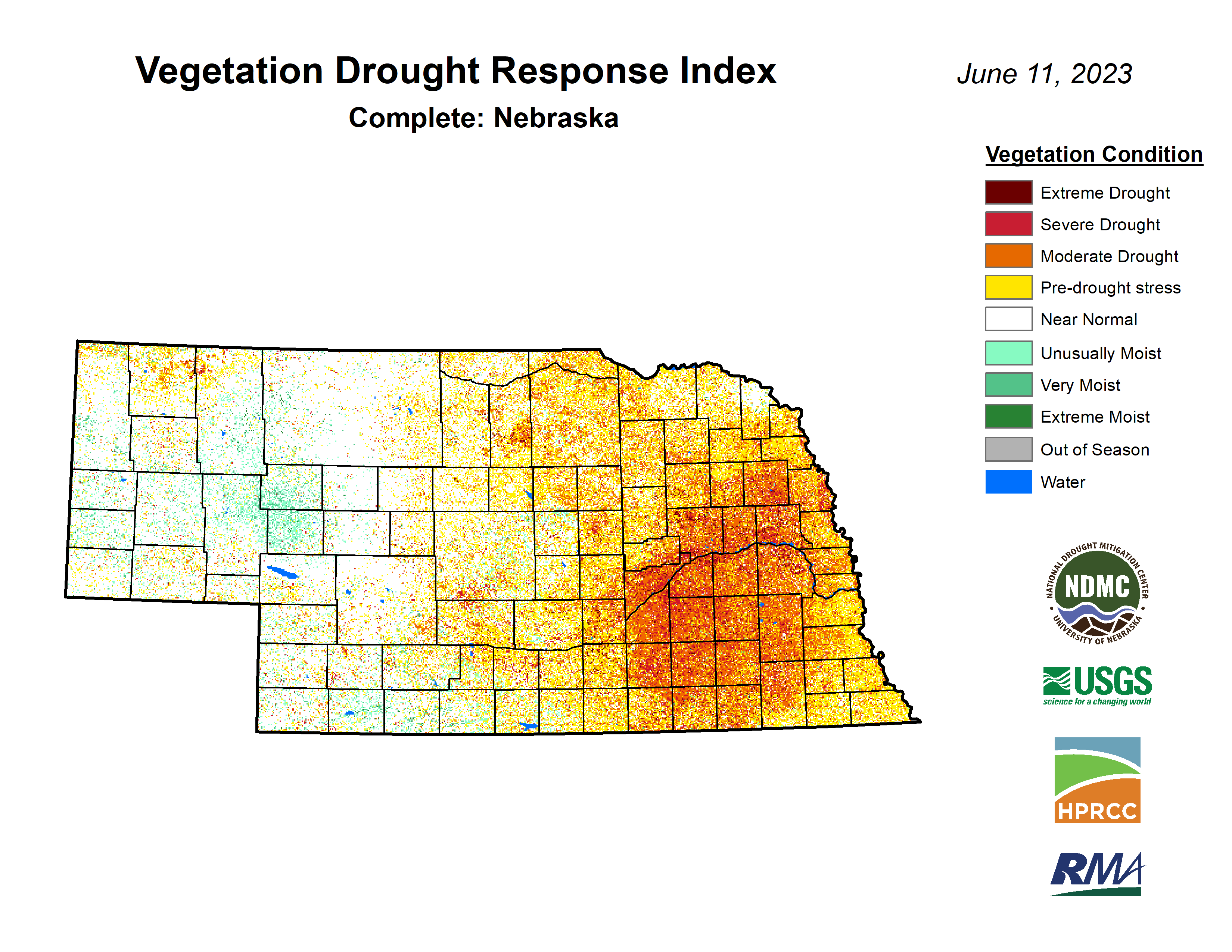
This also is reflected in the latest VegDRI update, which would indicate that most pastures in the western 1/3 of the state are healthy or in strong recovery mode. VegDRI also shows the severity of the drought in eastern Nebraska as well, with the most extreme conditions in the area that is in D3 and D4 on the Drought Monitor. The exception is across far northeast Nebraska where VegDRI is indicating more typical conditions, which may be an indication that the rainfall last week was fairly effective.