Drought Update
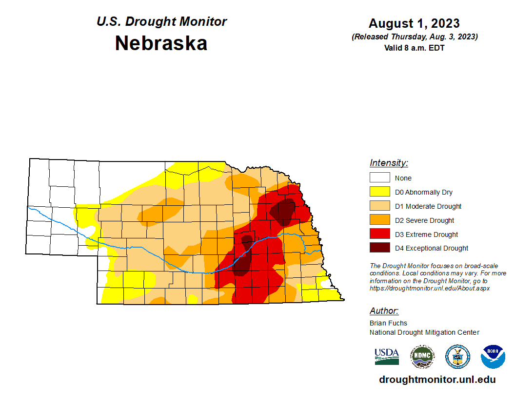
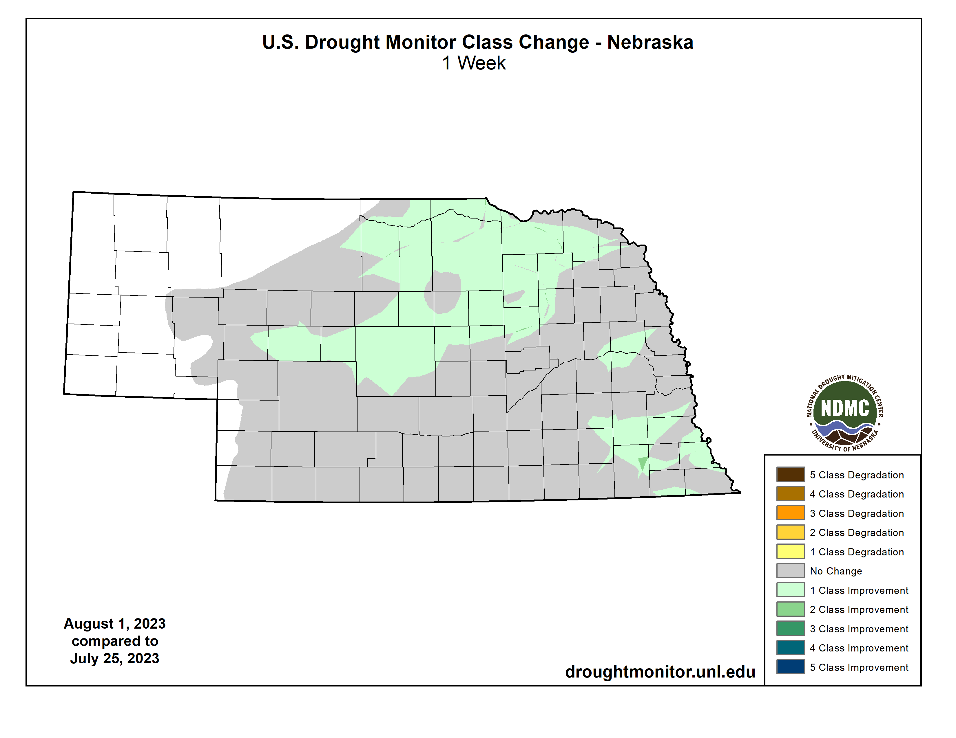
After a few weeks of mostly status quo, there are quite a few improvements to note on this week’s map. A large majority of the state is still in drought (64%) and roughly 16% is in extreme to exceptional drought. But both numbers represent improvements over last week’s map. Areas that saw improvement include a large chunk of north central and northeast Nebraska, northern Saunders and southern Dodge counties, and across a large portion of southeastern Nebraska. Expect to see additional improvements on next week’s Drought Monitor as several locations in drought have received significant precipitation since the data cutoff on Tuesday morning.
Precipitation Update
With the placement of the upper-level ridge a bit further south than last week, the state has been in a favorable area for precipitation. Not everyone has seen significant precipitation but most places picked up at least half an inch. Heaviest events occurred last Saturday morning (29 July) across portions of east central and southeastern Nebraska where upwards of 5” fell in some spots across southern Lancaster County and yesterday morning across the northern half of eastern and central Nebraska. The good news is that many of the locations that have picked up 2-3 inches over the last week are locations that really needed the precipitation.
Last week’s heat
The placement of the ridge last week put the state in the sauna or the blast furnace depending on where you were. Temperatures were over 90F every day in most of southwestern Nebraska where maximum temperatures averaged over 95F last week. Temperatures of 90F and higher were observed at least 4 days last week everywhere else in the state. The highest temperatures were found along the Kansas border between Red Cloud and Hebron where temperatures got into the 105-107F range last Wednesday-Friday. The highest heat index values were found across east central Nebraska from Lincoln to Columbus to Omaha, where a combination of temperatures in the upper 90’s to low 100’s combined with high dewpoints in the upper 70’s to low 80’s led to heat index values between 110-125F.
Soil Moisture
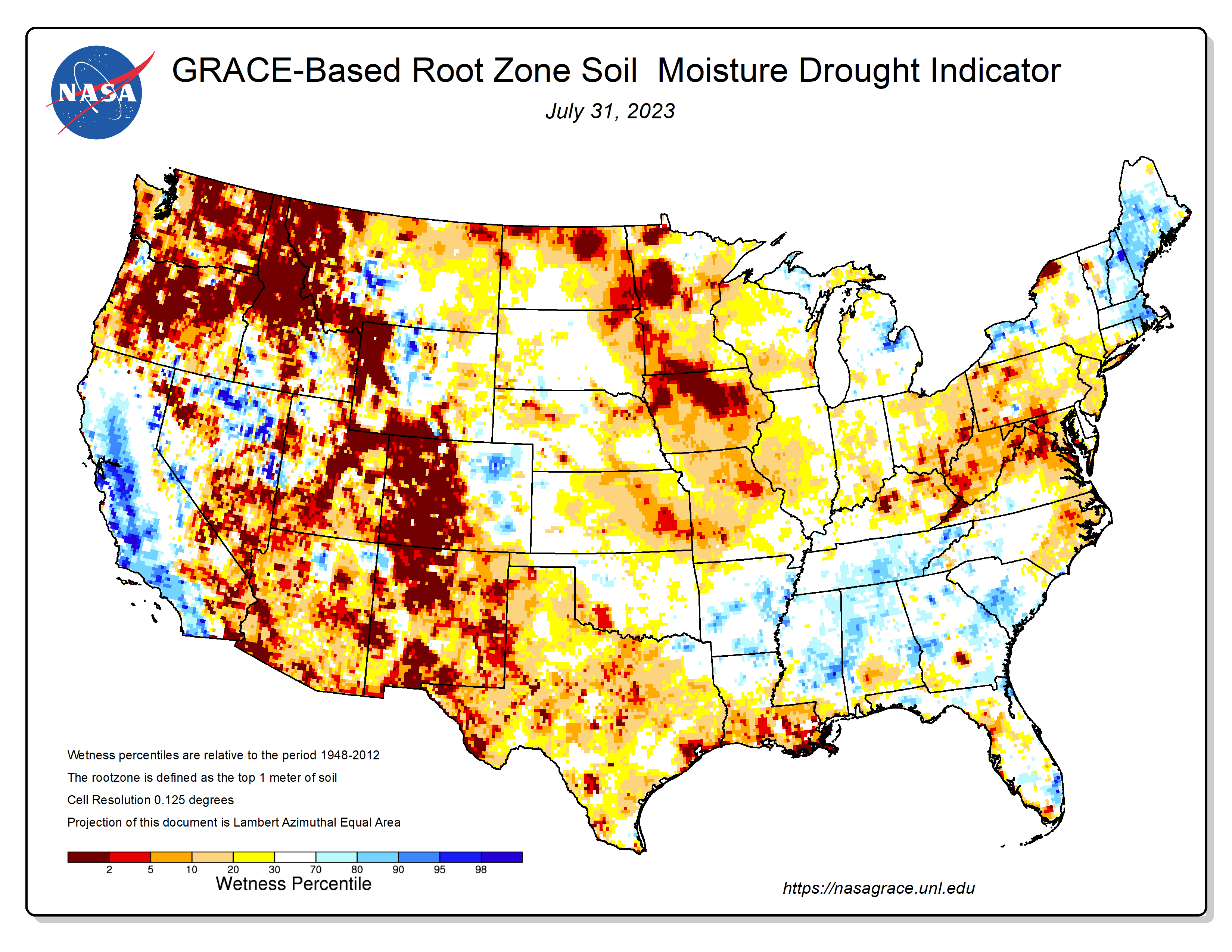
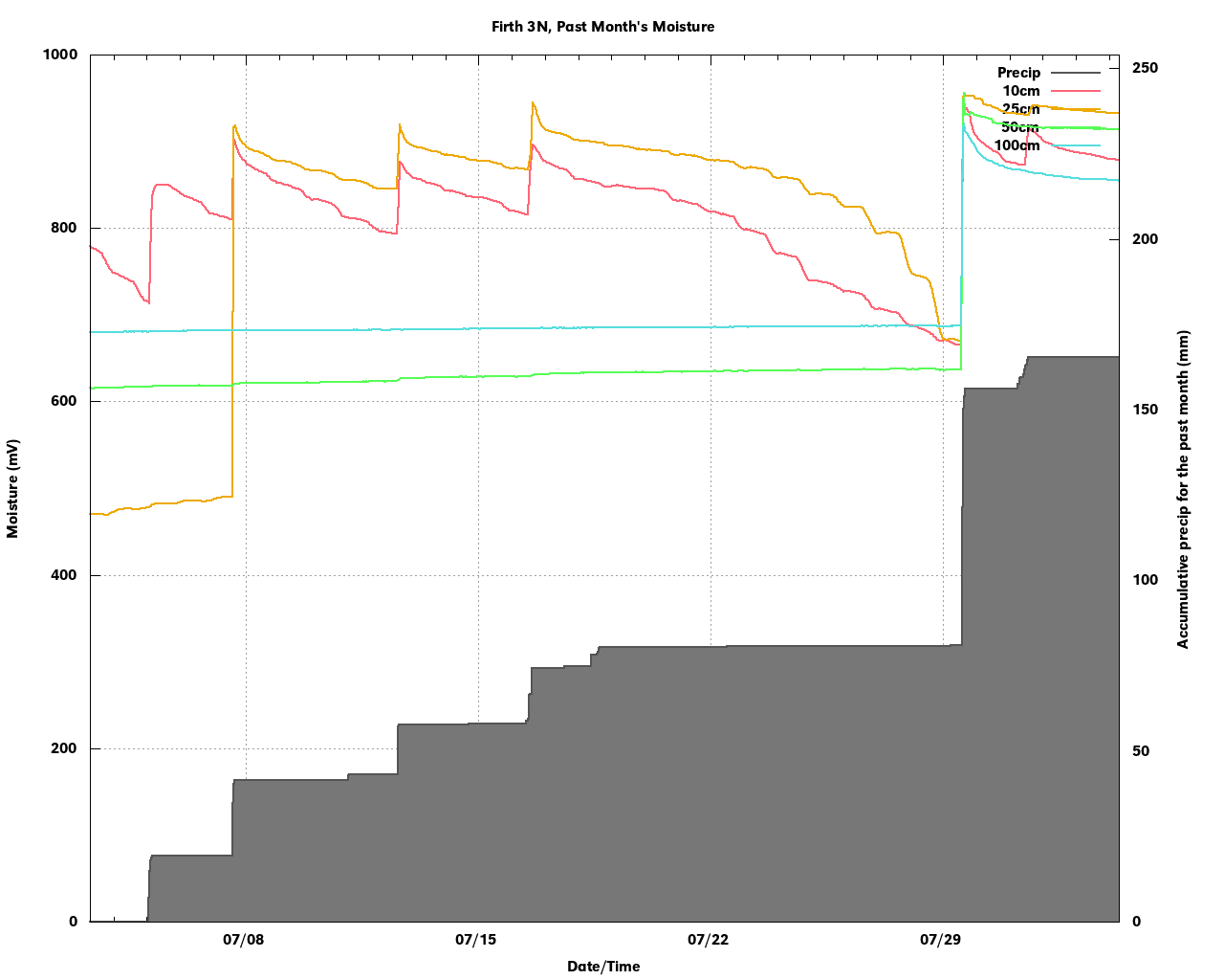
Speaking of soil moisture, the latest root zone percentiles map from GRACE shows that most of the state has root zone soil moisture at or slightly below where it normally would be in late July. A look at raw soil moisture data from sites in eastern Nebraska shows that many places had significant recharge of the deeper depths. The example from Firth (southern Lancaster County) shows that previous rainfall over the previous month failed to recharge but last Saturday’s gully-washer brought decent moisture all the way down to 100 cm. This is good confirmation that a lot of the heavy rain that fell last Saturday morning did indeed do a lot of good. Other sites in eastern Nebraska have shown similar responses with recent heavy rainfall events
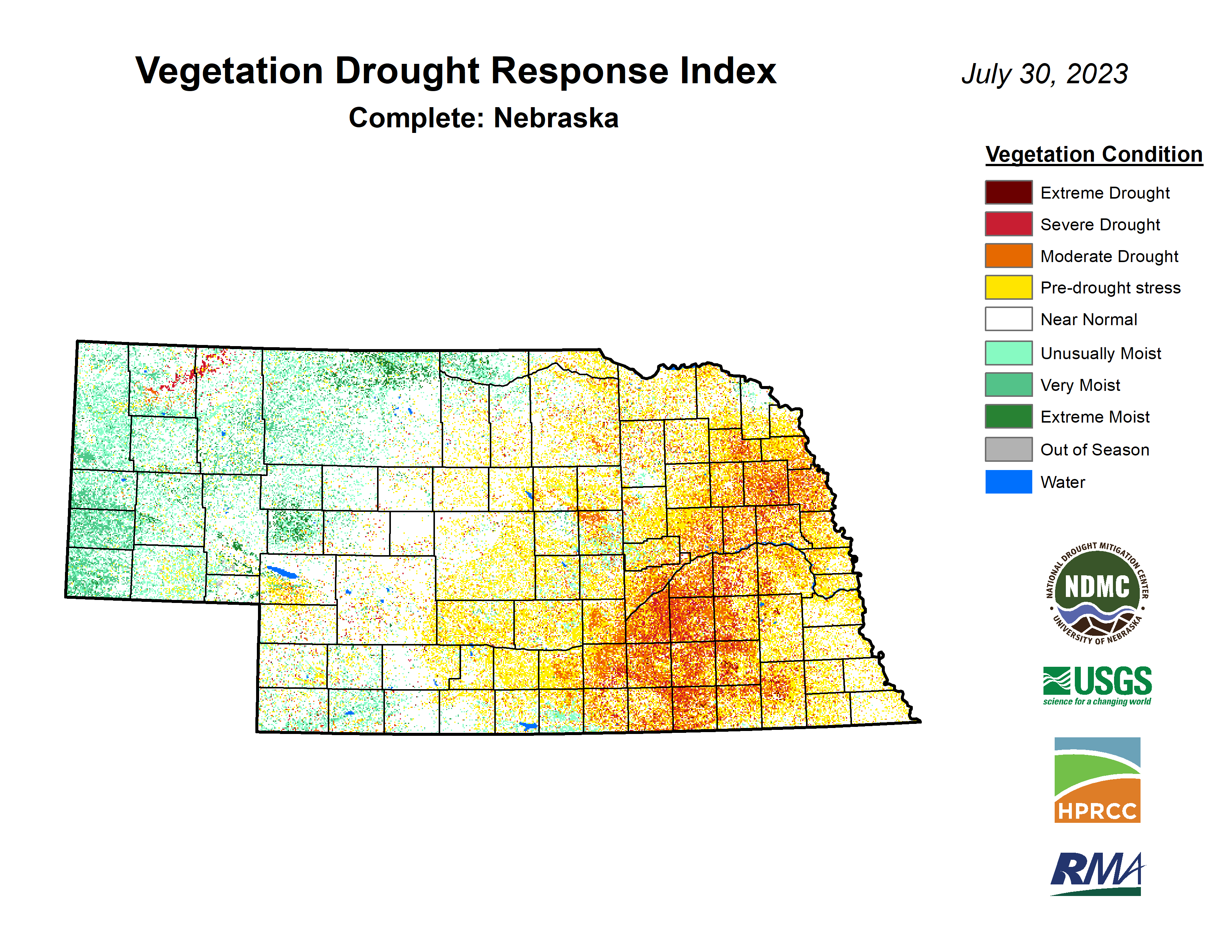
Vegetation and crop condition update
The latest VegDRI map continues to be in good agreement with the U.S. Drought Monitor map, which shows the worst conditions in the area between Grand Island and York and down toward the Kansas border with broad vegetation stress on rainfed crops in the areas west of Lincoln. Areas east of Lincoln are in much better shape. Conditions in the western third of Nebraska are quite good for this time of year, though the heat last week wasn't good for pastures with cool season grasses.
Pastures continue to improve slowly and the percentage of pasture statewide in poor to very poor condition is at 15%, higher than in recent weeks but still better than most of the last few years. 54% of statewide pasture is in good to excellent condition. Corn and soybean came in at 18% and 20% poor-very poor respectively on the latest NASS update. The soybean number has remained around that number for several weeks. The corn rating slid a bit this week though given the heat it is not surprising.
Corn is well into the reproductive stage with 21 percent into the dough stage, which is a bit below the 5-year average. This is likely a reflection of the cooler than average weather that prevailed for much of July. The silking percentage is above the 5-year average of 87 percent. About half of the state’s soybean crop in the state is setting pods, which makes the recent precipitation critical. The percentage in pod setting numbers are right around the 5-year average. 34 percent of the sorghum crop has headed and is in reasonably good shape with 62 percent considered good-excellent. It is behind on heading, also due to the cooler temperatures that prevailed in recent weeks. Wheat harvest accelerated last week but is still not over. Recent precipitation across western Nebraska isn’t going to help finish harvest.
Eric Hunt, University of Nebraska Extension and Nebraska State Climate Office