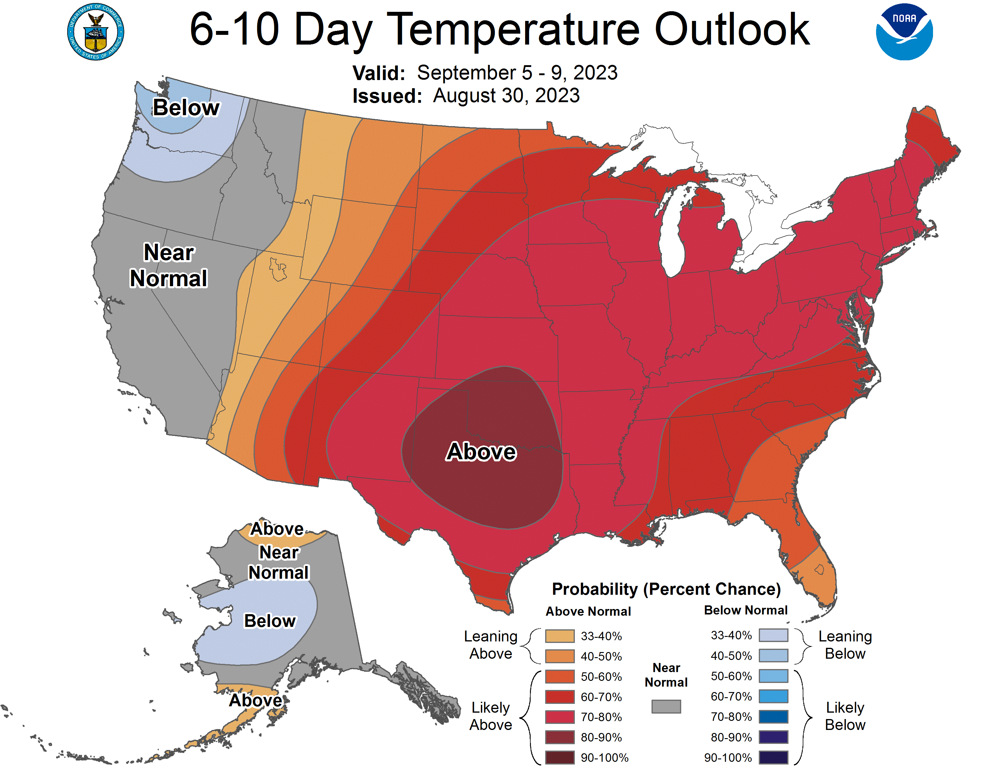
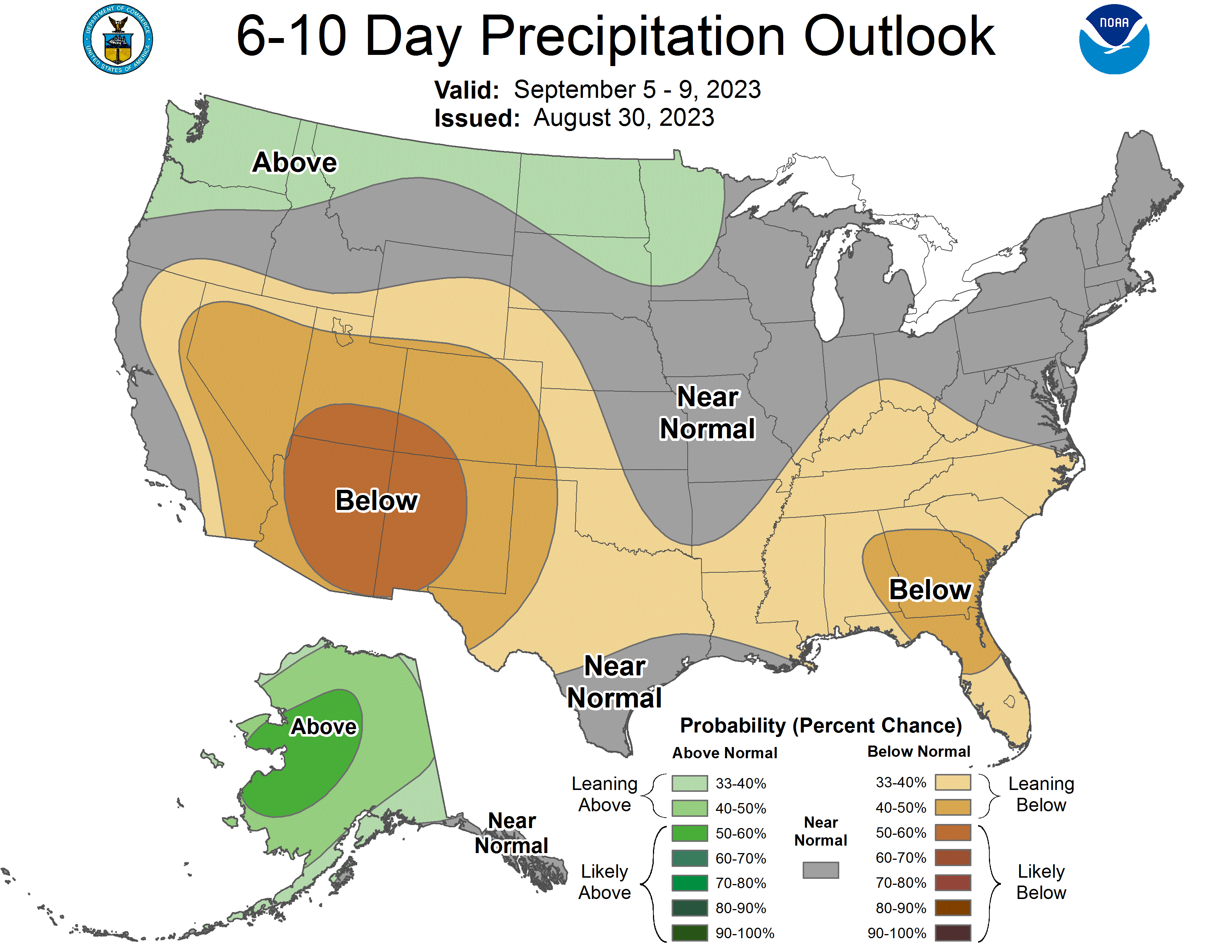
Week Ahead Outlook
After a nice break from the heat, we are entering into another stretch of hot weather. It already has started in western Nebraska where temperatures were in the low to mid 90's yesterday. The good news is that won't be as hot or as humid as the last heat wave. But it will still be well above average for early September and temperatures likely will be at or close to 100F near the Kansas border this weekend and likely will be in the lower 100's in parts of northeast Nebraska. A weak cold front will be moving through the state on Tuesday, which should drop temperatures down somewhat for the middle of next week. The worst news for crops and pastures that need a drink is that widespread precipitation does not appear likely, with the possible exception of parts of western Nebraska. There is some chance for rain on Tuesday evening/night in central and eastern NE but we will need to get better moisture up from the Gulf to get that to happen. If the moisture transport is a bit more robust of if local ET helps moisten the lower boundary layer some, then we could squeeze out a half inch in more places. Regardless- September appears to be shaping up to be quite warm and dry.
Precipitation and Drought Monitor Update
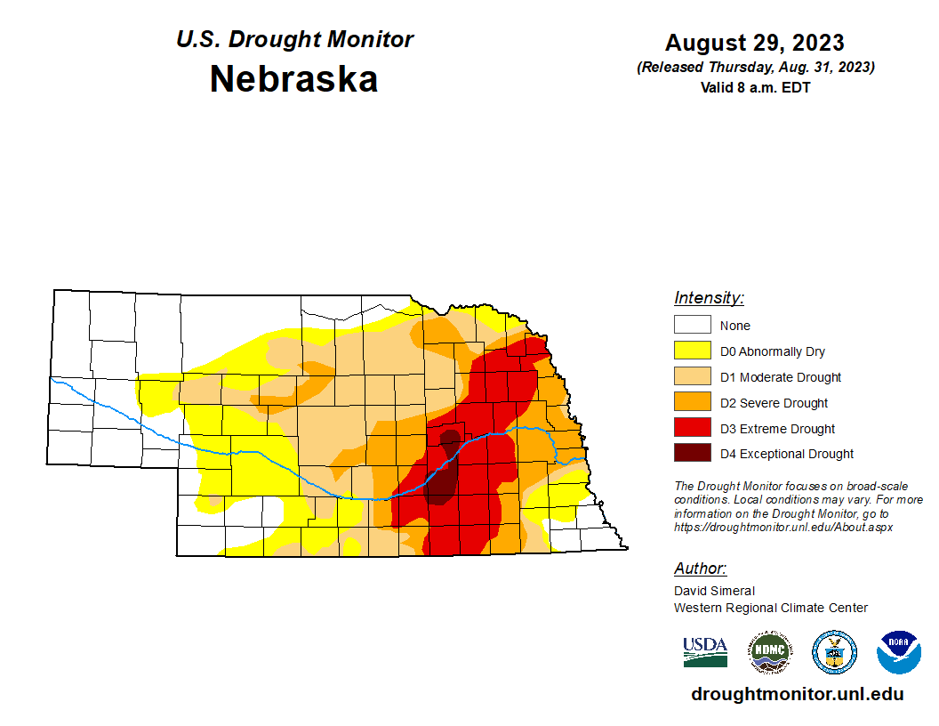
Remnants of Tropical Storm Harold interacted with a slow moving cold front last Friday night and Saturday morning to help provide significant amount of rain to much of the southern third of the state. 1.0-1.5" totals were widespread in the southern Panhandle and in south central and southeast Nebraska between I-80 and the Kansas border. There were also pockets of widespread 2-4" in Adams, Cass, Clay, Franklin, Jefferson, Kearney, Lancaster, Nuckolls, Saline, Thayer, and Webster counties. In the southeastern quadrant of Nebraska, this led to broad 1-category improvements on the U.S. Drought Monitor with parts of Cass County improving 2 categories. We are now down to 50 percent of the state being in drought and 31 percent of the state is free of drought and abnormal dryness.
Soil Moisture Update
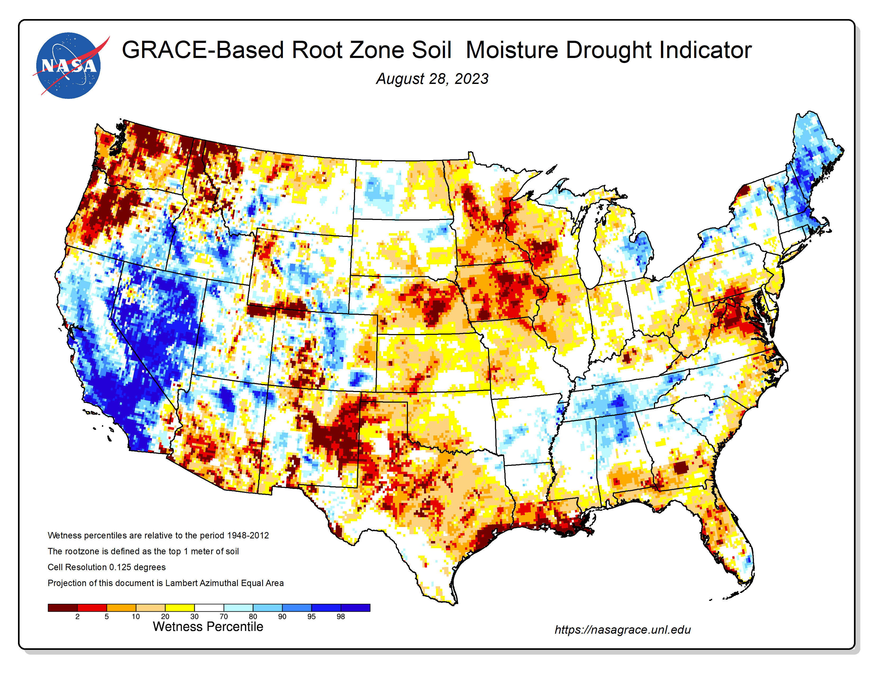
A quick look at soil moisture from the Nebraska Mesonet shows that there was significant moisture added in the top foot of the profile in places that picked up more than 1.5" Some parts of central and eastern Nebraska picked up a quick thunderstorm on Friday afternoon with the frontal passage. But most of north central and the northeastern quadrant of Nebraska missed out on rain and have not had meaningful rain in the last two weeks. The NASA GRACE map shows that most of the state is on the drier side for root zone soil moisture, with only parts of the panhandle having soil moisture in the 70th percentile or better.
Vegetation and Crop Condition Update
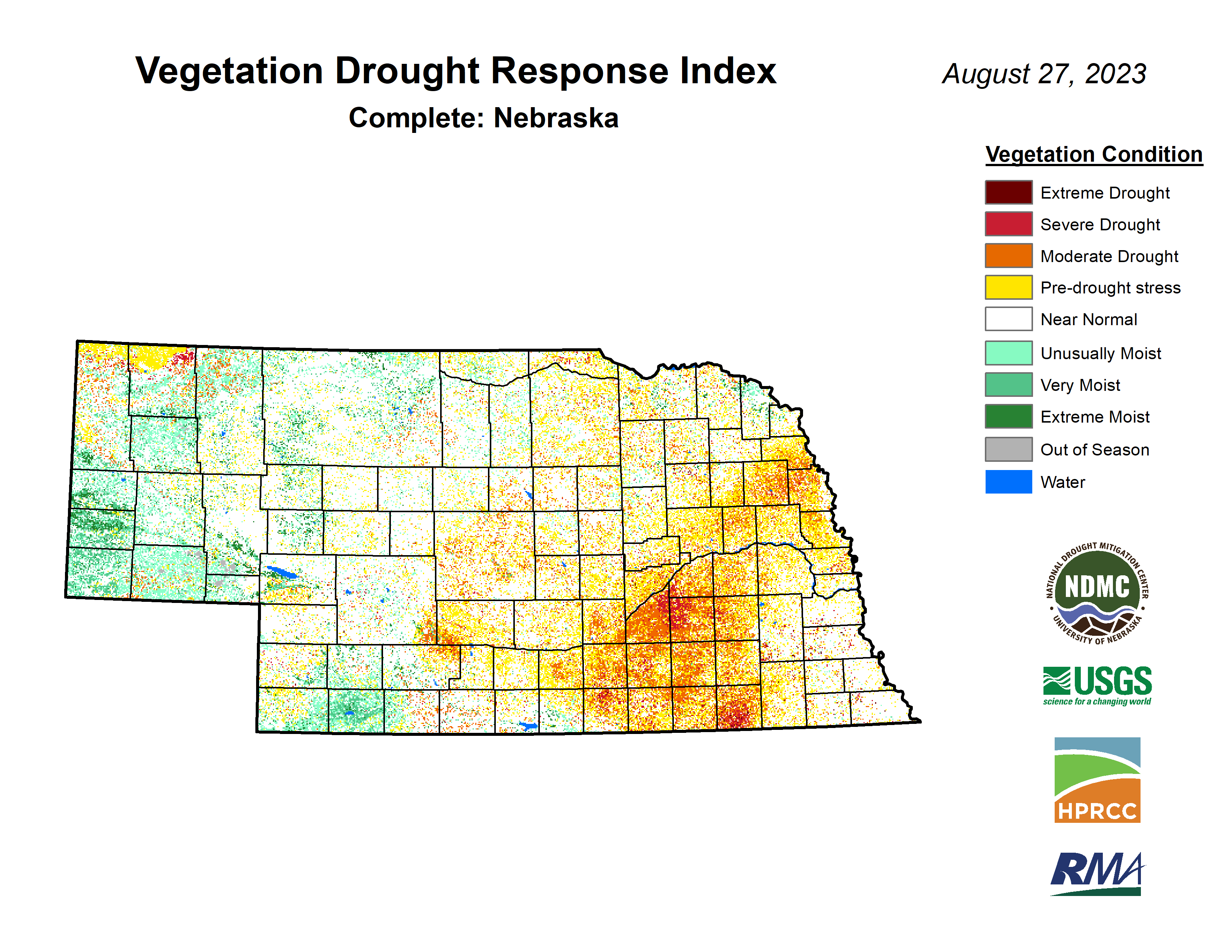
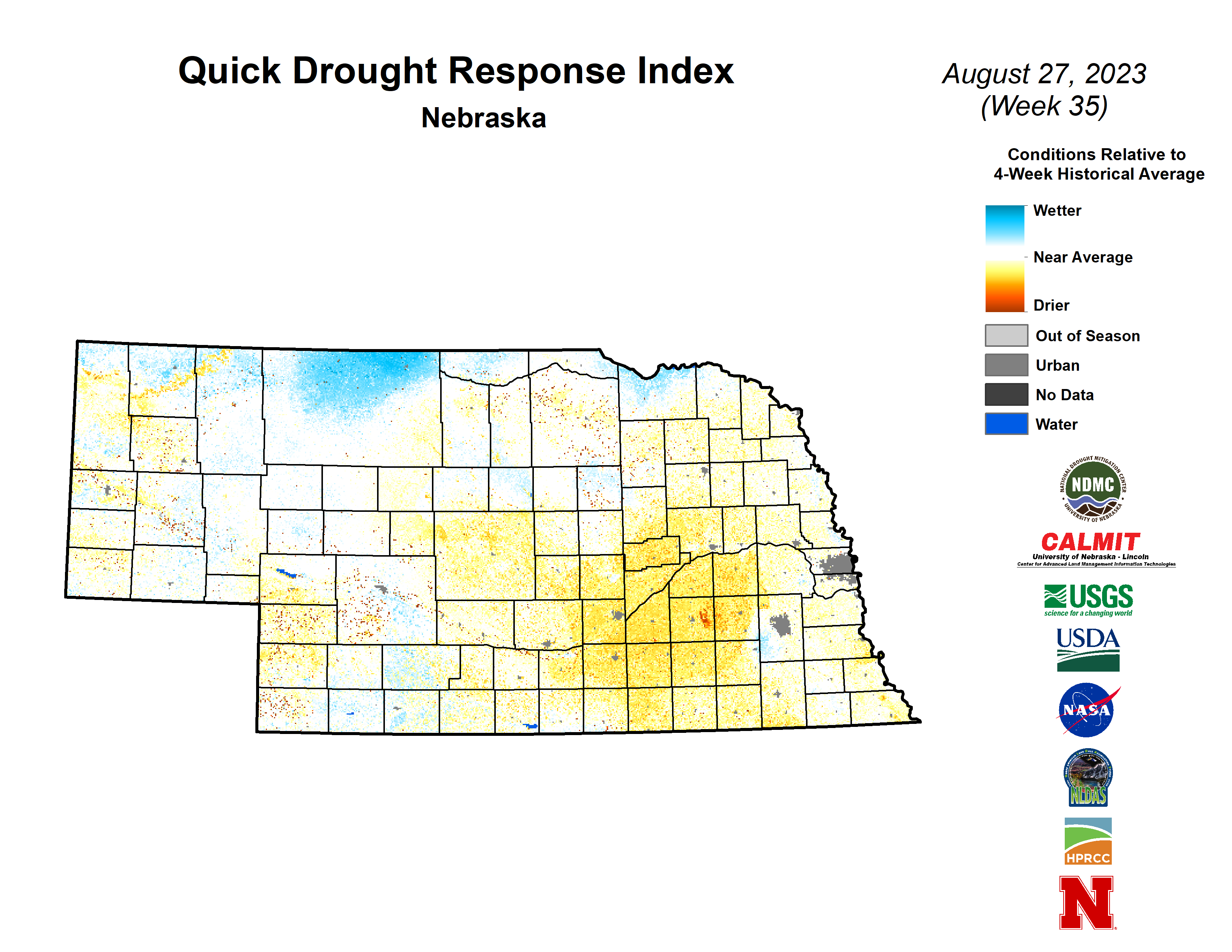
VegDRI continues to show the most acute dryness occurring from Grand Island to Seward and down to the Kansas border. There was also a noticeable degradation across Jefferson County over the past week. Maybe some of the precipitation last week helped. QuickDRI also shows this same area as being stressed and also is picking up on the relative dryness across central Nebraska over the past 3-4 weeks. QuickDRI is depicting widespread average to moist conditions, reflective of healthy vegetation, across Cass, Otoe, and southeastern Saunders counties.
The most recent Crop Progress Report shows that corn is a bit ahead of schedule with 59% in the dent stage. The heat last week was not helpful. Condition ratings as of Monday showed 54% good to excellent (G-E) and 24% poor to very poor (P-VP), which is a big increase in P-VP over the previous week. This is likely a guarantee that statewide corn yield will be under trend, though I still suspect it is better than last year. The big unknown is whether it is 5 bpa better than last year or 15 bpa better.
Soybean is around the 5-year average for setting pods (92%) and dropping leaves (8%). Soybean comes in with a condition rating of 52% G-E and 24% P-VP, a comparable decline to what we saw from corn. The lack of rainfall in the last 14 days for northeast Nebraska is not leading to a good finish for rainfed soybean crops. The heat coming back isn't going to help. Sorghum is checking in with 64% in G-E and 10 % P-VP and is about on track for coloring (44%). Pasture condition ratings also took a big step back from where they have been in recent weeks with 52% G-E and 22% P-VP.
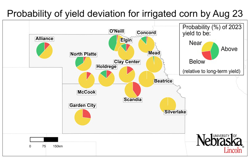
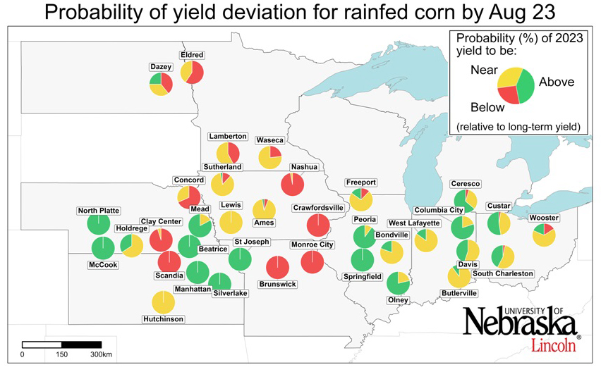
Dr. Patricio Grassini's group also released their latest simulated corn yield probabilities late last week. Their results, which are based only on weather data, show a strong probability of near-trend yields for irrigated corn. Rainfed corn is highly dependent on location. Yields are expected to be above average in western NE and far eastern NE but are pretty much guaranteed to be below average in central/east central NE. I can confirm from extension educators that rainfed corn yields in parts of southern NE will be under 20 bpa this year.
Eric Hunt, University of Nebraska Extension and Nebraska State Climate Office