


Very mild week ahead
After a brief cool down to more seasonal levels the next few days, a large mid-level ridge will set up over the north central U.S. early next week and remain in our area for several days. If this pattern was setting up shop in July or August, I'd be warning you about oppressive heat being likely for parts of the state. But since it's November this will have the effect of delivering beautiful weather. Expect ample sunshine and mild temperatures statewide Monday-Thursday with 70F temperatures not out of the question next Tuesday and Wednesday in the southeastern portion of the state. In general, temperatures will be above average all week and 10-15F above average next Tuesday-Thursday.
Storm on the horizon?
As we head into the latter portion of next week, a trough will begin moving from the southwestern U.S. into the central U.S. The exact track, strength, and timing is uncertain and I recommend paying attention to the forecast next week as details become more clear. Nevertheless, there does appear to be a chance that our area will be in the favored left exit region of a modest subtropical jet, which would help support upper level divergence and surface convergence. In English, this means that models are showing the atmospheric dynamics would favor development of a surface low in our general neck of the woods and bring precipitation to at least the eastern third of the state.
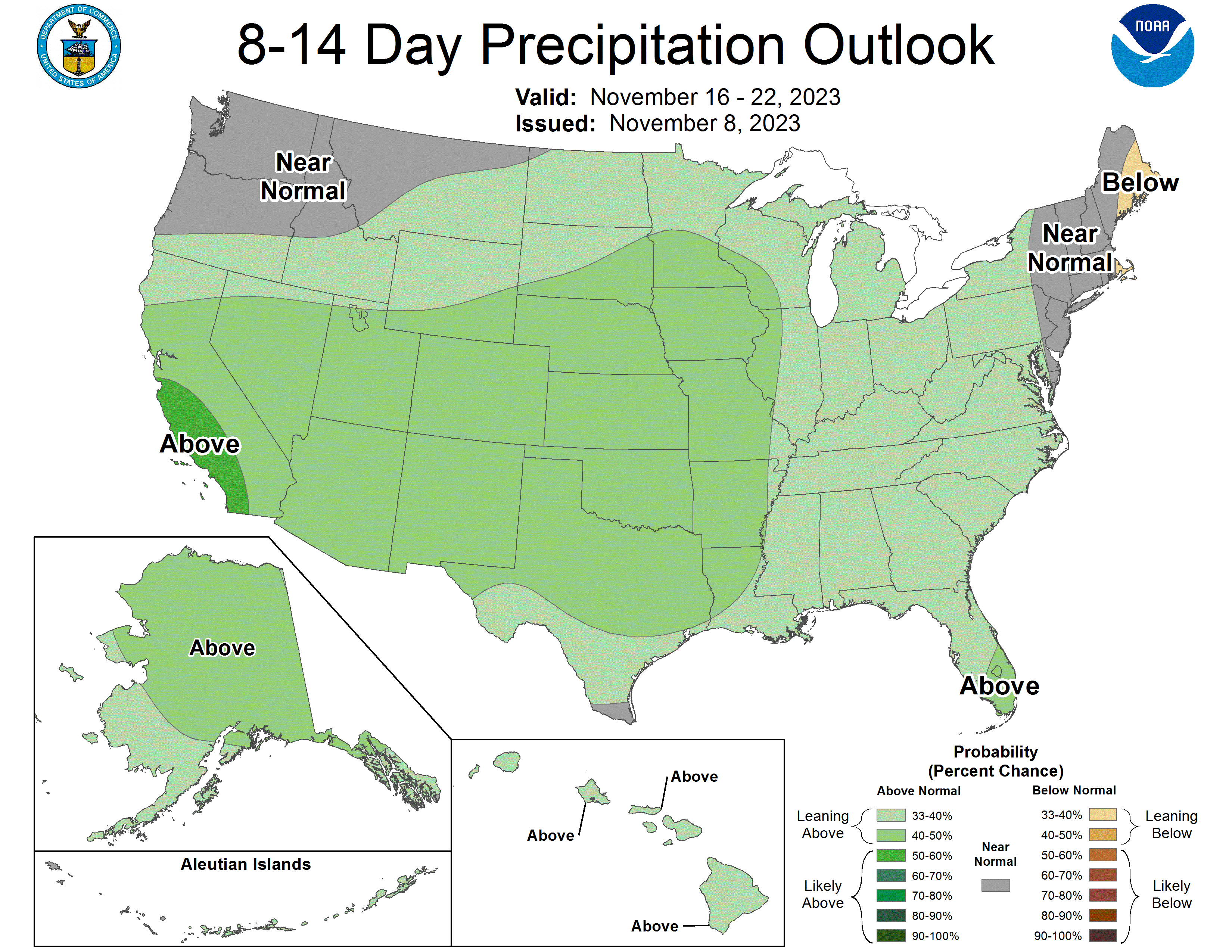
The good news for those who aren't wanting to be concerned about a snowstorm is there isn't going to be much influence (or any) from the polar jet. Thus temperatures should remain mild and plenty warm enough for just rain. For what it's worth, the current 8-14 day precipitation outlook from the CPC is bullish on above average moisture for the entire state. Meaningful rain for the whole state has yet to be a consistent signal in the ECMWF and GFS but the location of the jet and surface low will dictate who gets rain. Too early to make a realistic assessment on amounts but my initial hunch is a reasonable chance at a half inch of moisture in the eastern section of the state with a lower chance of a 1-2" type event.
Drought Monitor and Precipitation Update
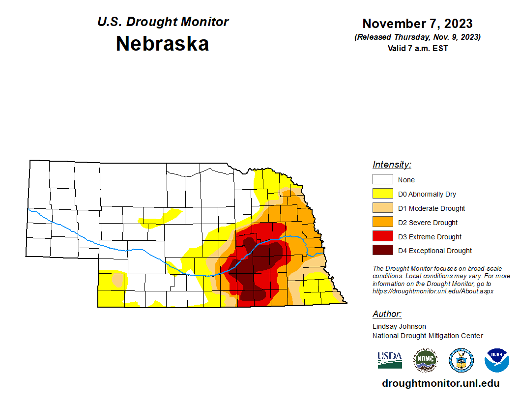
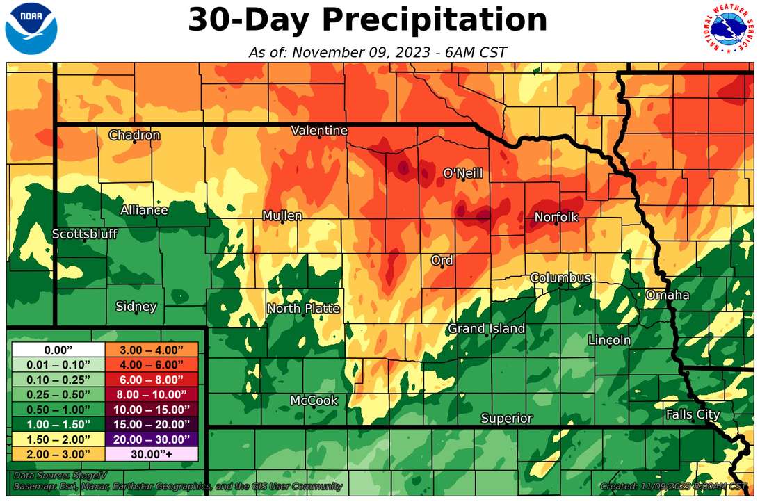
Speaking of precipitation, the southeastern corner of the state would certainly benefit from having an inch of moisture as it's been quite dry this fall. It's been dry enough that there has been some degradation on the last few U.S. Drought Monitor maps, with some introduction of D1 drought into Cass County last week and additional degradation to D0/D1 in several areas to the southeast of Lincoln. The good news is that after improvements on last week's map, the amount of drought in the state is right around 25 percent and 60 percent of the state is free and clear of all drought and abnormal dryness. For the latter, that is the best we have been since June 2020. The recent improvements in central, north central, and northeast Nebraska were brought on by robust precipitation in the last 30 days with many areas north of the Platte receiving 5+ inches of rain.
Soil moisture update
The most recent SPoRT LIS map indicates that soil moisture is generally below the 10th percentile south of the Platte and generally in good shape north of the Platte. This map has been more or less like this since the heavier rains back in mid-October in the northern half of the state. The good news is that there is reasonably adequate soil moisture going into the winter for much of the state, which generally hasn't been the case since 2019.
Pasture and wheat update
Good news to report is that pasture (as of late October) were over 50% good-excellent (G-E), which is a dramatic improvement over late April when it was functionally 0 percent. The winter wheat crop is also off to a much better start than last year with 50 percent considered G-E and 15 percent poor-very poor.