


Storms and cool weekend ahead
The storm system currently affecting the state will start to slowly move out of the region by Saturday. For the rest of today, there is a risk of severe storms in eastern Nebraska, a risk of flash flooding in parts of northeastern and north central Nebraska, and accumulating snow in the higher elevations of the Panhandle. Pinpointing total rainfall amounts for tonight is a bit tricky but most of eastern Nebraska should see over half an inch from thunderstorms and any short-term training could mean some spots get decently over an inch. Most of the northeastern quadrant of the state has picked up well over an inch, with excessive amounts of 5-8" in parts of Antelope, Holt, and Wheeler counties.
Tomorrow will be a cool, raw day for most of the state with highs not getting out of the 40's for areas west of Highway 81. Rain will still be likely across most of northeastern and east central Nebraska through tomorrow afternoon but amounts should be in the 0.10-0.25" range. The biggest issue tomorrow though will be high wind speeds, particularly between Highway 83 and Highway 281, where winds could gust over 50 mph at times.
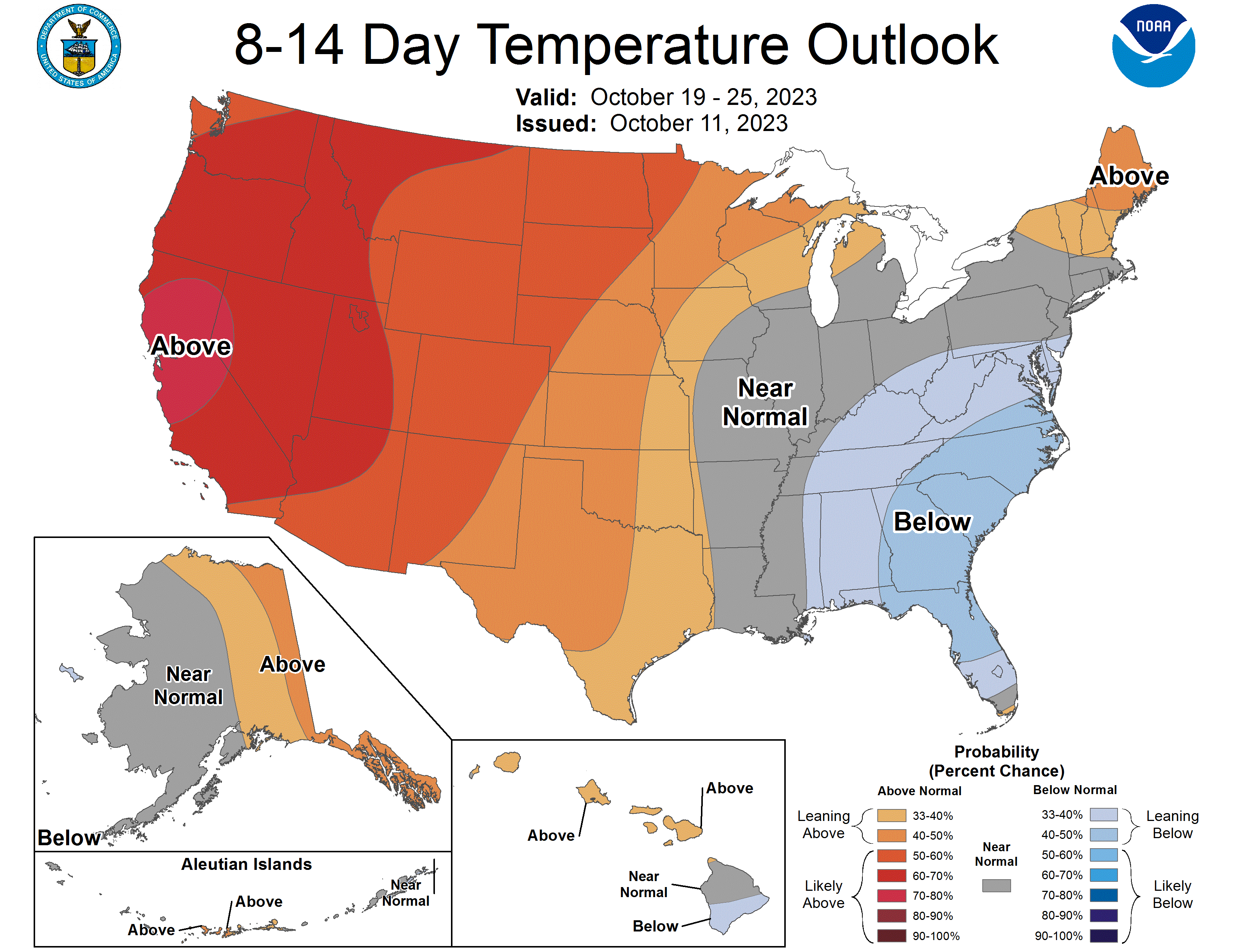
Saturday will be a slight improvement over Friday with a bit lighter winds and some clearing. But it will still be on the cool side with most of the state staying under 55F and some parts of north central and northeast NE won't hit 50F. Parts of far southwest Nebraska may sneak up closer to 60F on Saturday. Sunday will be a bit warmer than Saturday and should feature sunshine for everyone and lighter winds. A light freeze is certainly possible for much of the western half of the state on Sunday morning and again on Monday morning. Current forecast is for most of east central and southeast Nebraska to remain above freezing for minimum temperatures during this period but there is a chance of it being colder than currently forecast if winds can go near calm.
Typical Fall Week
Most of the next week looks fairly typical for our region of the country in mid-October. Temperatures should moderate to more seasonal levels on Monday and Tuesday, with temperatures over 70 likely in the Panhandle, Southwest, and possibly as far as east as Lincoln in the southern half of the state. A cold front will move through the state Tuesday night into midday Wednesday, which will bring rain chances for most everyone. At this time it looks like a short-lived event with most places not picking up more than a 0.25" and some places won't get anything. Temperatures will cool back to the 50's on Wednesday and Thursday before moderating back into the seasonal 62-70 range by the weekend. Right now the weather appears to be very nice for the football game. Beyond next week it appears our area will be under the influence of more upper level ridging, which should keep us on the dry and seasonally warm side.
Soil Moisture and Vegetation
The latest SPoRT LIS map from late yesterday (00Z 12 October) shows that most of the state was below the 30th percentile, though I think it might be overdoing the dryness in western NE. Regardless, root zone soil moisture has improved since the beginning of the month for a broad swath of eastern and south central Nebraska. This is good news for next year's winter wheat crop. The plus of having soils be on the drier side is field work can be resumed more quickly after an inch of rain this year than it would have in say 2018 and 2019 when we had surpluses for most of the state. A quick peek at the rangeland specific VegDRI map shows that pasture conditions are mostly in good shape west of the 100th meridian. Conditions are a bit poorer in central Nebraska but generally showing just abnormal dryness. Exception to this can in Loup, Garfield, and Valley counties where there are pixels with more stress. This overlaps well with the U.S. Drought Monitor.
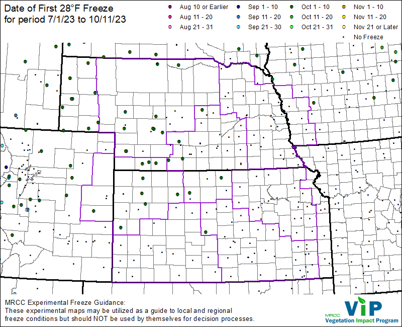
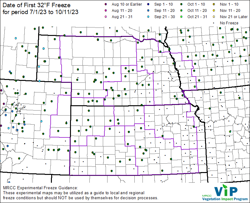
Season's First Freeze
With the first decent blast of cool air this season late last week brought the first light freeze for a large portion of the state. Temperatures managed to drop to 28F across most stations in the western third of the state, with a few readings in the 22-24 range in the western Sand Hills last Saturday morning. Further east temperatures weren't quite as chilly but much of northeast Nebraska managed to drop to 31-32 briefly this past Saturday and/or Tuesday morning. A few sites in southeast Nebraska has also dropped to 32 last Saturday morning. But much of what I'll classify as the Highway 6 corridor from Hastings to Omaha managed to stay above freezing during the last week. Some of those sites closer to Hastings are likely to have the first 32 (or below) reading this weekend and it's possible the broader Omaha-Lincoln area could drop that low Monday morning if radiational cooling is optimal. But looking ahead a bit, if temperatures stay above freezing Monday morning in east central Nebraska, we may need to start talking about the possibility of having the latest first freeze on record for places like Lincoln, Omaha, and Wahoo.
Crop Condition Update
Corn is at 94% maturity (5% points ahead of schedule). Corn harvest is moving along at 32% complete, which is 7 points ahead of the 5-year average but 1 point behind last year. Soybean harvest has accelerated and was 52% complete as of Monday. This is up from 29% last week and 6 points ahead of the 5-year average. 83 percent of sorghum was mature and 18% had been harvested. Winter wheat planting is nearing completion with 91% planted and 65% has emerged. No ratings were given on wheat yet but my understanding is the wheat crop is off to a good start in western Nebraska. Pasture ratings were about the same as last week with 54% G-E and 19% P-VP.
Eric Hunt, University of Nebraska Extension