


Bottom Line Up Front:
The next 7-10 days could feature a bit of severe weather in far eastern NE, heavy rain across a broader swath of eastern NE, possibility of cold temperatures statewide (but especially in the Panhandle and North Central sections), and even a chance of heavy snow. More on the possibility of a White Halloween in a bit.
Weekend Weather into early next week
Game day looks to have near perfect football weather here in Lincoln. A bit of a breeze from the NW and temperatures in the 60's. Expect it to be a bit warmer across the southern part of the state and a bit cooler in north central and northeastern Nebraska. On Sunday, a weak shortwave will traverse the state and bring a chance of showers to western Nebraska on Sunday morning and in the eastern half of Nebraska in the afternoon and early evening. Amounts should be reasonably light where precipitation does fall. A front will enter the state from the northwest on Monday, which will bring seasonally cool afternoon temperatures in the Panhandle, but not much of a chance of rain it appears. Further east Monday looks quiet and seasonally warm, especially along and south of I-80 from Kearney to Omaha. Expect temperatures to possibly flirt with 80 in parts of southeastern Nebraska. There will be a bit more moisture to work with in eastern Nebraska and storms, including a slight risk of severe storms, could affect areas from West Point down to Beatrice and points east from Monday night into Tuesday. This chance seems to be getting lower based on recent model runs though.
Drought Easing Rain
Before you get too excited about drought easing rains, that there is still some uncertainty in this forecast. The following things are still unclear:
Strength and placement of upper level trough: Current prognosis is an upper level trough will dive into the Southern Rockies and then move northeast into the Central Great Plains by Wednesday afternoon. However, if the storm and its surface counterpart end up being weaker than is currently forecast, then the rainfall amounts will certainly be less than current projections. If it ends up being even stronger, then there could be some enhanced rainfall amounts and potential flooding risk in northeast Nebraska where more rain has fallen of late. The placement and movement is also important. A track that is more NE than NNE would mean significantly less rainfall north of I-80 and more in Kansas, Missouri, and southern Iowa. I'm leaning more toward the ECMWF's NNE movement of the storm from New Mexico but I wouldn't put a lot of money on that down at Warhorse Casino.
Southeastern ridge: There is signal in the models for a stronger ridge of high pressure to develop over the southeastern U.S., which would greatly enhance moisture transport from the Gulf of Mexico. That a ridge will be in place in that region in 5-7 days seems likely but the strength and placement of it will help dictate the moisture transport north and potentially how that storm system moves once it rounds the corner so to speak. The ridge also may affected by what ends up happening with Tammy. Referring to Hurricane Tammy in the Atlantic of course and not Tammy Wynette, the country singer who passed 25+ years ago. Speaking of the tropics...
Norma: Another factor of uncertainty is how the remnants of Hurricane Norma affect the U.S. in the next week. Norma is expected to affect the southern Baja region this weekend before heading into western Mexico by Monday morning. Some of the moisture may make its way to the north during the week. Suspect most of it will stay south of the border or at least south of 30N, there is a possibility that Norma's moisture could get "fed" into the coming storm system. This would allow for more precipitable water in the eastern third of Nebraska, which would lead to higher rainfall potentials.
A White Halloween?
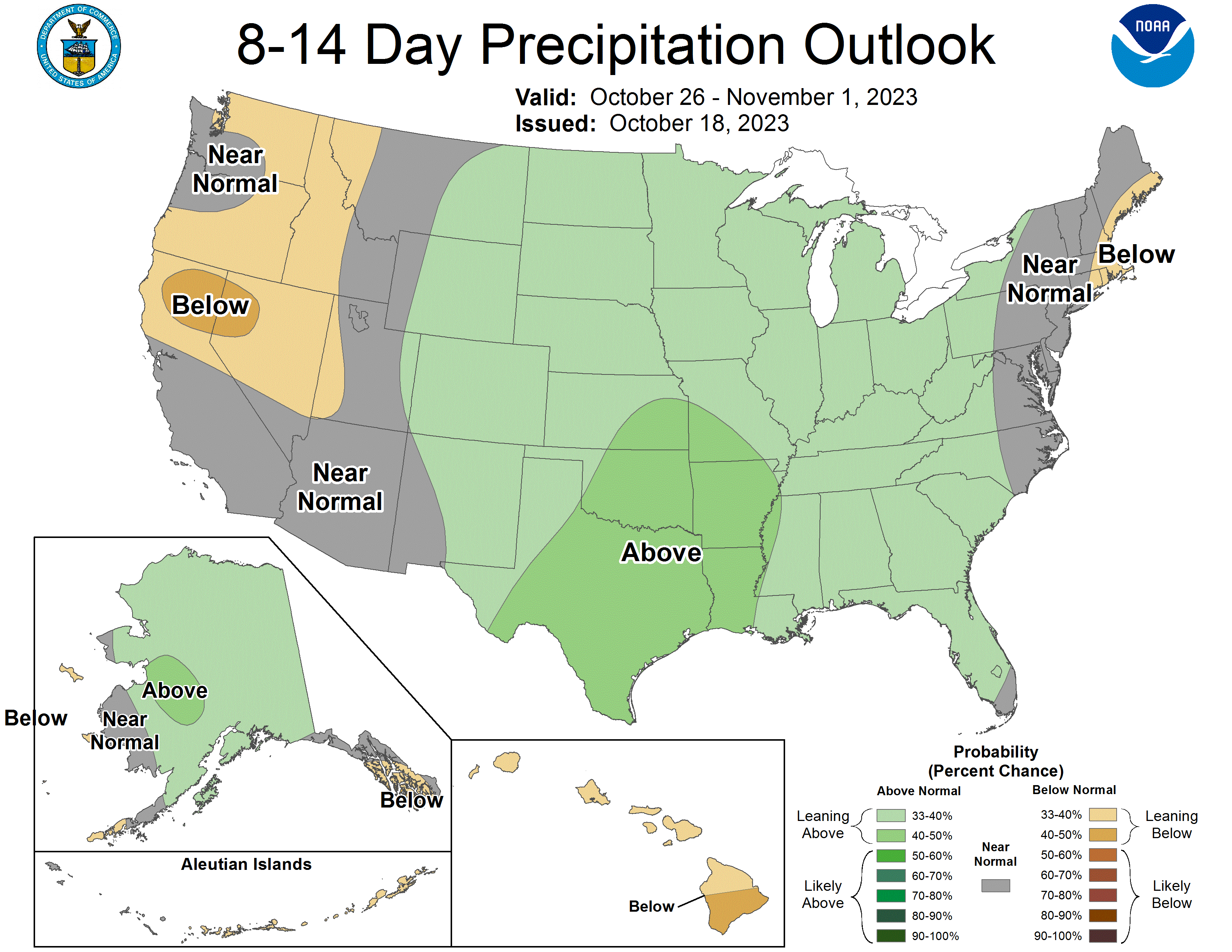
The next item of interest is the CPC putting much of the north central U.S., including Nebraska, into the slight risk category for heavy snow in the period between October 26th and November 1st. Before getting too excited (or upset) about this possibility of having a White Halloween, let's take a deep breath and acknowledge two things that may appear to be contradictions but are both true:
First, heavier snow in late October is certainly not be unprecedented by historical standards, especially in western and north central Nebraska. Many people have memories of the October 1997 storm that dumped upwards of 18" in some parts of south central Nebraska or the Halloween of 1991 when a mix of snow and icy sidewalks cancelled Halloween in some communities in eastern NE. So there is historical precedent for it and thus, can't totally discount it.
Second, the hazard for heavy snow is more a reflection of the 12Z GFS operational run from yesterday that put down a foot-plus of snow from Wyoming through northwestern and north central NE and South Dakota northeast into Minnesota and Wisconsin next Thursday. Today's 00Z GFS had no heavy snow anywhere in the north central U.S. and today's 12Z GFS puts heavy snow in Montana and North Dakota and lighter snow in Nebraska. Point here is there is a tremendous amount of spread just within one model. The ECMWF, which is statistically superior to the GFS and typically outperforms it, has been more consistent with keeping snow well to our north in the Canadian prairies in recent days.
The chance of heavy snow affecting most of Nebraska before Halloween is in the same ballpark as Nebraska winning the Big 10 west this season if they lose on Saturday
There's historical precedent for winning a Big 10 division and it's not technically impossible to still win the division with a Northwestern loss, but it's definitely not the most likely outcome. They should win Saturday though.
How cold is it going to get later next week?
One of the most important ingredients for snow is having some deeper cold air in place. Even that seems to be in question. Both the GFS and ECMWF show a deeper trough moving into the western and north central states in the next 10 days. The difference is the GFS is much faster with its progression east into our area and brings light snow and temperatures in the 30's next Saturday. The ECMWF is considerably slower with the trough. It is suggestive of high temperatures in the 50's and 60's next Saturday, albeit perhaps a bit breezy and maybe on the cloudier side in the west. Regardless that is a big difference in sensible weather across the state. My hunch is to think the ECMWF is closer to reality as it tends to be on the right side of trends in the 7-10 day time frame more quickly than the GFS. But we shall see. It does appear that colder air will be invading the entire state by Halloween or November 1st though.
Precipitation and Drought Monitor Update
The powerful storm that affected the state last week brought rain to the whole state but amounts varied from under a quarter inch down around Superior to 10" on the Holt-Wheeler County line. Most of the northern third of Nebraska picked up 1.5-4" last week, with heavy totals extending into Custer and Dawson counties as well. This led to widespread improvements of 1-category in the north central and northeastern sections of the state and even some pockets of 2-category improvements in Cherry, Wheeler, Holt, Antelope, Pierce, and Madison counties. With these improvements, we now are down to 32 percent of the state in drought (big improvement from 99 percent 6 months ago!) and up to 39 percent of the state being in "None". The last time we had this much "None" was back in mid-June 2021 and hopefully we can have a lot more "None" a month from now. The only degradation to report is a small area of Chase County which went from D0 (abnormal dryness) to D1 (moderate drought).
Soil Moisture, Vegetation, and Harvest Update
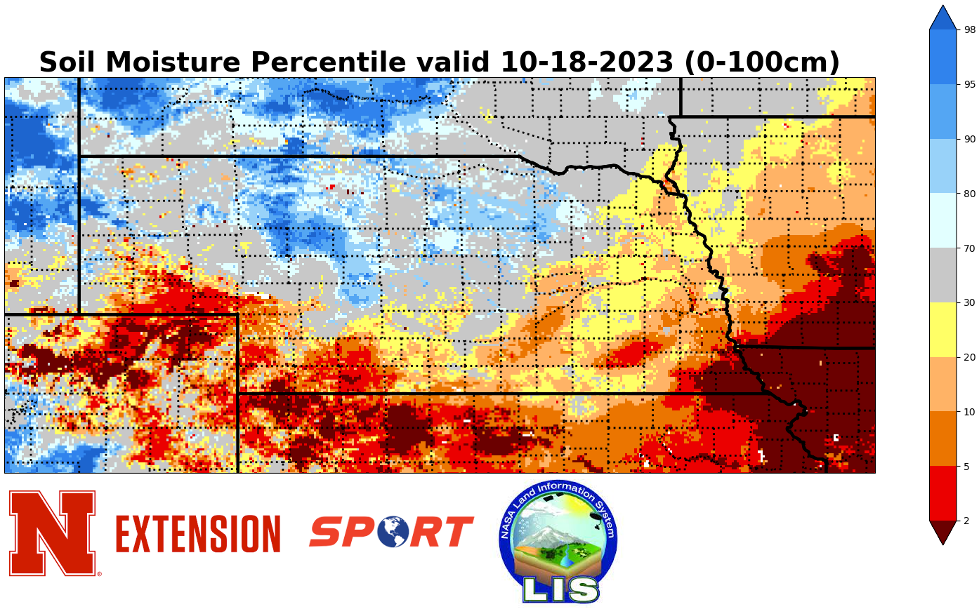
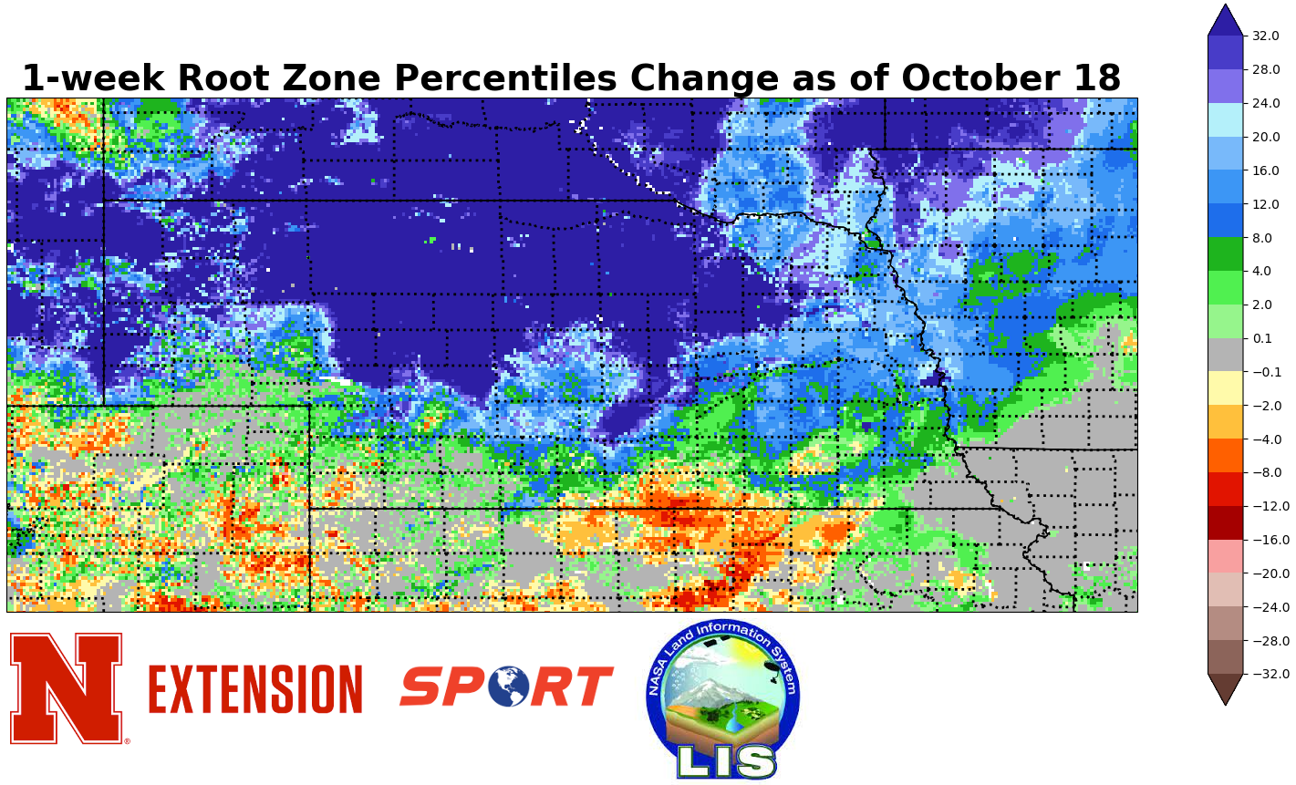
Root zone soil moisture is in or headed toward being in good shape across most of the northern third of the state, with most places being average or a bit wet according to the SPoRT percentiles map. Biggest improvements (30+ points) were predictably in the places that had the most rainfall. More modest improvements were noted in the I-80 corridor from Grand Island to Omaha and some parts of south central and southwestern Nebraska saw some decreases in the root zone percentile. Again this is simply a statistical view of soil moisture relative to the time of year and not an absolute amount of moisture. Regardless, soil moisture is heading in the right direction across much of the state
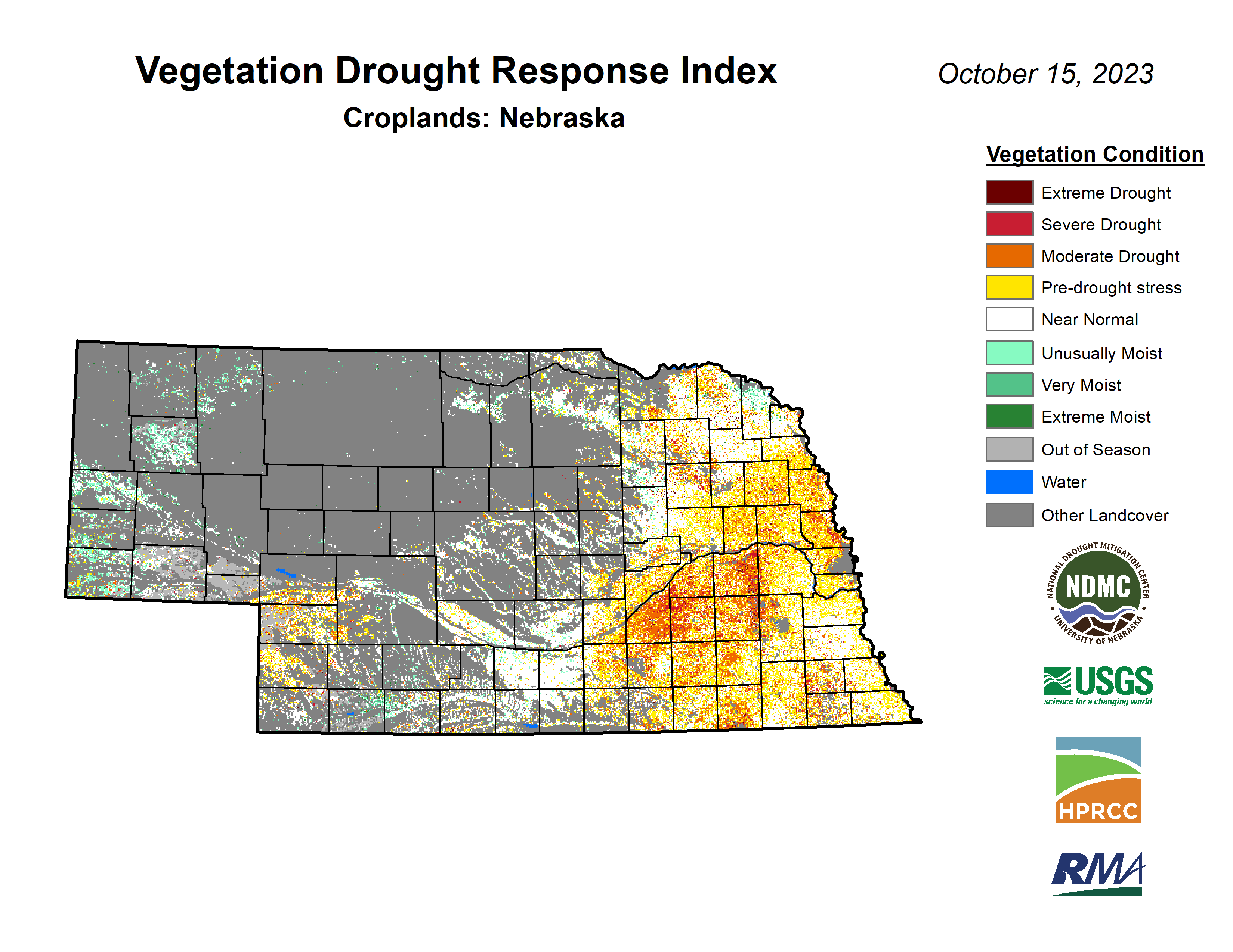
Now that warm season crops like corn and soybean are harvested, VegDRI is not going to be as useful in those cropped areas. However, at this time of year it can be a good indicator as to the progress and health of the winter wheat crop in western Nebraska. Good news is that VegDRI is depicting a good start for next year's winter wheat crop in the Panhandle, where a lot of the state's production is these days. Discussions with educators in that part of the state confirm the wheat crop is off to a good start this year. VegDRI isn't as good in the southern border counties further east but that may well be a reflection of the 9-month SPI being reasonably negative.
Corn harvest was at 44% (same as at this point last year) and soybean at 70% on the latest NASS Crop Progress Report. Both are ahead of the 5-year averages but soybean harvest has accelerated much more quickly than the corn in the last three weeks. Yields are mixed but generally not great due to disease and weather issues. Almost all winter wheat has been planted and 86% had emerged.
Eric Hunt, University of Nebraska Extension and Nebraska State Climate Office