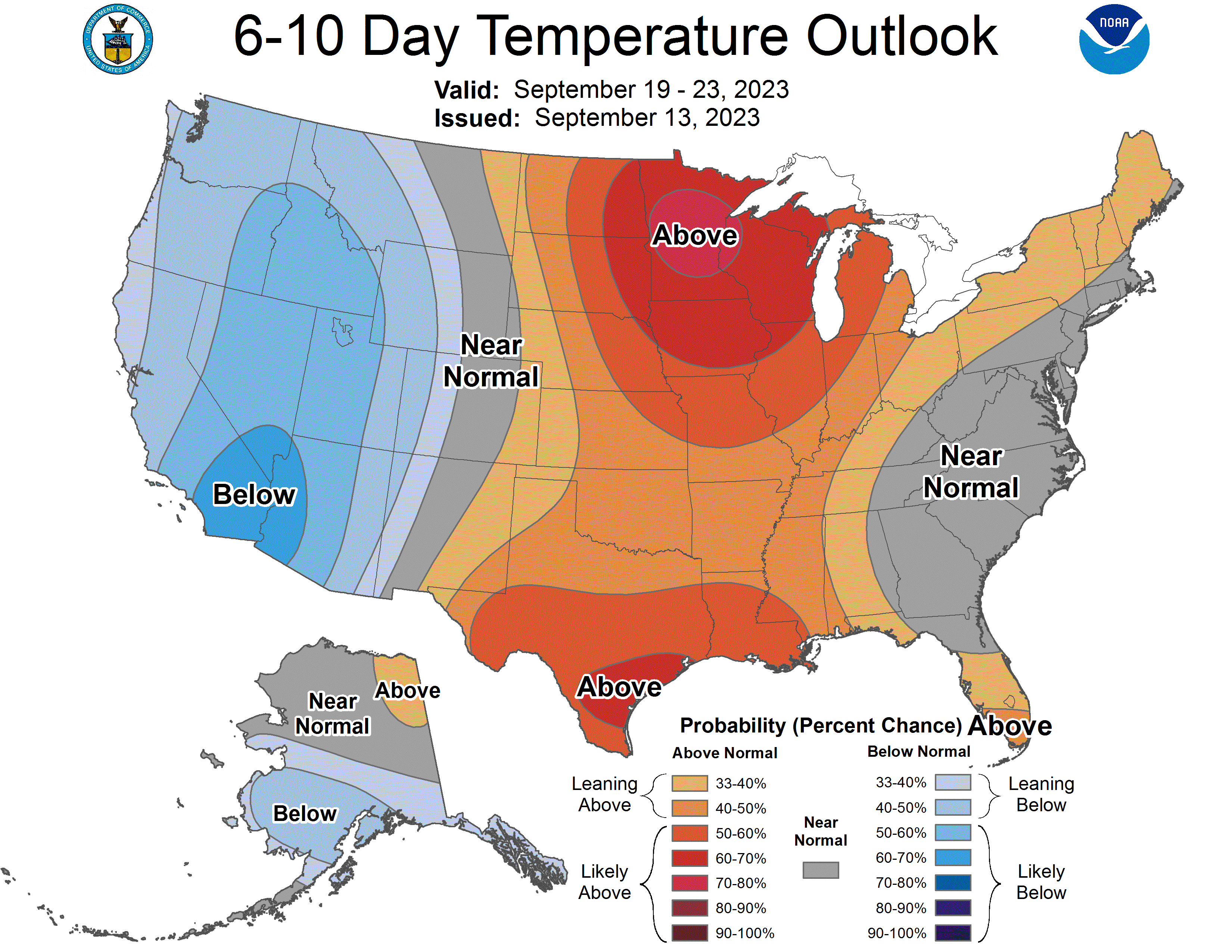


Week Ahead Outlook
The week ahead looks to bring a mix of some beneficial rain and beautiful weather. Tomorrow a cold front with an associated area of low pressure in southern Canada will help lead to widespread showers across the state later tonight in western Nebraska and during the day tomorrow in central and eastern Nebraska. Precipitation amounts look to be heavier in west central Nebraska and lightest in east central Nebraska. Still most places should pick up a tenth of an inch in the next 24 hours. After the frontal passage a beautiful few days look to be in store for the state, with temperatures slightly above seasonal norms. But in mid-September that means highs in the low 80's, not the mid 90's. As we get into mid-week, we will start experiencing effects from a trough in the western U.S. that will help to draw some moisture into our area from the south. It appears that there will be scattered showers and thunderstorms in central Nebraska next Wednesday and into eastern Nebraska next Thursday and Friday. A stronger storm may be moving into the state next weekend that would bring more copious amounts of precipitation. Regardless, the CPC is favoring above average temperatures and precipitation for most of the remainder of the month.
Precipitation and Drought Monitor Update
Almost everyone in the state had precipitation last weekend but the amounts were not equally distributed. Several areas of the state picked up over an inch and some didn't manage a tenth of an inch. Big winners were an area from Scottsbluff to Chadron, from west of McCook up into western Custer County, and then across the northeastern corner of the state. Amounts generally were lightest from central Lancaster County down to Thayer and Jefferson counties. The precipitation did lead to some improvements on the map and now less than half of the state (47%) is in drought. Additionally, there was eradication of the last of the remaining D0 in the Panhandle with Garden County now being free and clear of everything. Other areas that saw improvement include western Custer County, Hitchcock County, parts of Rock, Brown, and Holt counties, and western Wayne County. There was some degradation to D0 (abnormal dryness) in western Keith and western Perkins counties.
Soil Moisture Update
Soil moisture did improve somewhat on the latest root zone product that is produced via the NASA GRACE product, though most of the eastern half of the state is still below the 30th percentile for root zone soil moisture. Some pockets of east central Nebraska are in the bottom 5th percentile. This does not mean only 5 percent of available water over the whole root zone but we are generally deficient, particularly at deeper depths in the eastern half of the state.
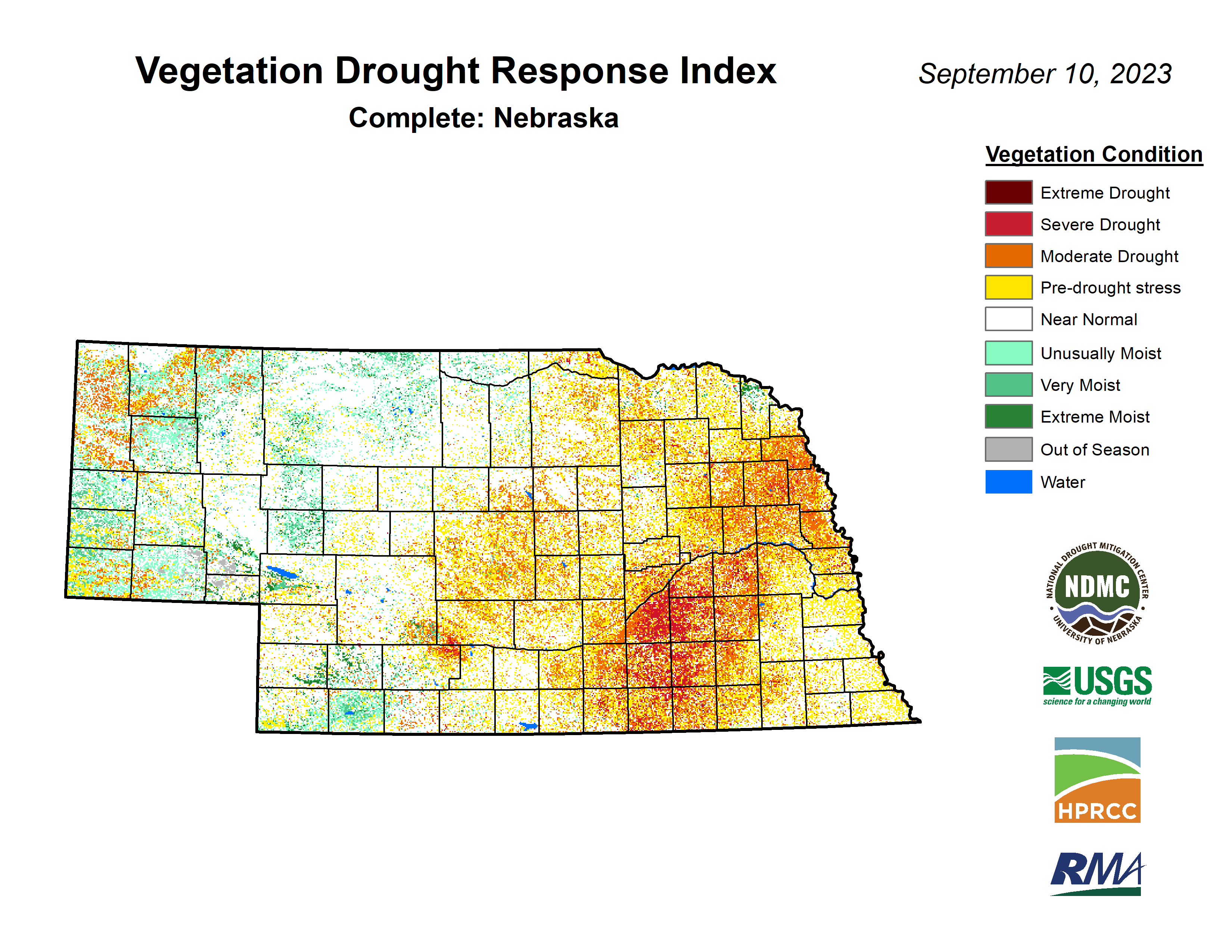
Vegetation and Crop Condition Update
VegDRI continues to show the most acute dryness occurring from Grand Island to Seward and down to the Kansas border. The most recent Crop Progress Report shows that corn is ahead of schedule with 24% at maturity. The heat the past few weeks most assuredly helped accelerate the corn and a sign of reduced yields. Condition ratings as of Monday showed 51% good to excellent (G-E) and 25% poor to very poor (P-VP).
Soybean is around the 5-year average for setting pods (96%) but well above average for dropping leaves (30%). Soybean comes in with a condition rating of 46% G-E and 29% P-VP, around where it was last week. Sorghum is checking in with 60% in G-E and 11% P-VP and is ahead of schedule for coloring (85%) and maturity (16%). The percentage of pasture conditions rating as good or excellent had a big decline for the third week in a row coming in at 36% G-E and 26% P-VP. But the forecast is favorable for that number to start going in a positive direction again.
Eric Hunt, University of Nebraska Extension and Nebraska State Climate Office