Week Ahead Outlook
The most pressing concern is the chance for severe thunderstorms and localized heavy rainfall amount for large portions of the state in the next few days. As of this writing on early Thursday afternoon, portions of northeastern Nebraska have already picked well over an inch of moisture and more is on the way. There will be additional chances for storms this evening in eastern Nebraska and the high-res models are getting more bullish on a thunderstorm complex developing over south central Nebraska late this evening and moving ENE into the Lincoln and Omaha metro areas overnight.
As we get into the day tomorrow, the best chances for severe, supercell type thunderstorms appear to be in the northern section of the state. But there is a chance of storm development further south into portions of central Nebraska as well. Saturday is perhaps the most interesting day as the upper level low moves into eastern South Dakota and a cold front will extend to the south of it. If there is not widespread convection overnight tomorrow, we avoid getting "dry slotted" from the southwest in the lower layers of the atmosphere on Saturday, and the cold front hasn't accelerated into Iowa, thunderstorm development along and east of Highway 81 in the afternoon would be very possible. If things line up, this is a favorable setup for storms to produce hail, high winds and maybe a few tornadoes (particularly in northeast Nebraska) between 2 and 8 PM in the eastern third of the state. While the rain is certainly welcome, high winds aren't and would potentially be a big problem for fields of corn where stands are weaker. Those going to the football game should also be prepared to possibly take shelter for an hour. But it may end up being a decent afternoon for a game if the front has already cleared our area by early afternoon. Recommend paying close attention to the forecast tomorrow night and Saturday morning.
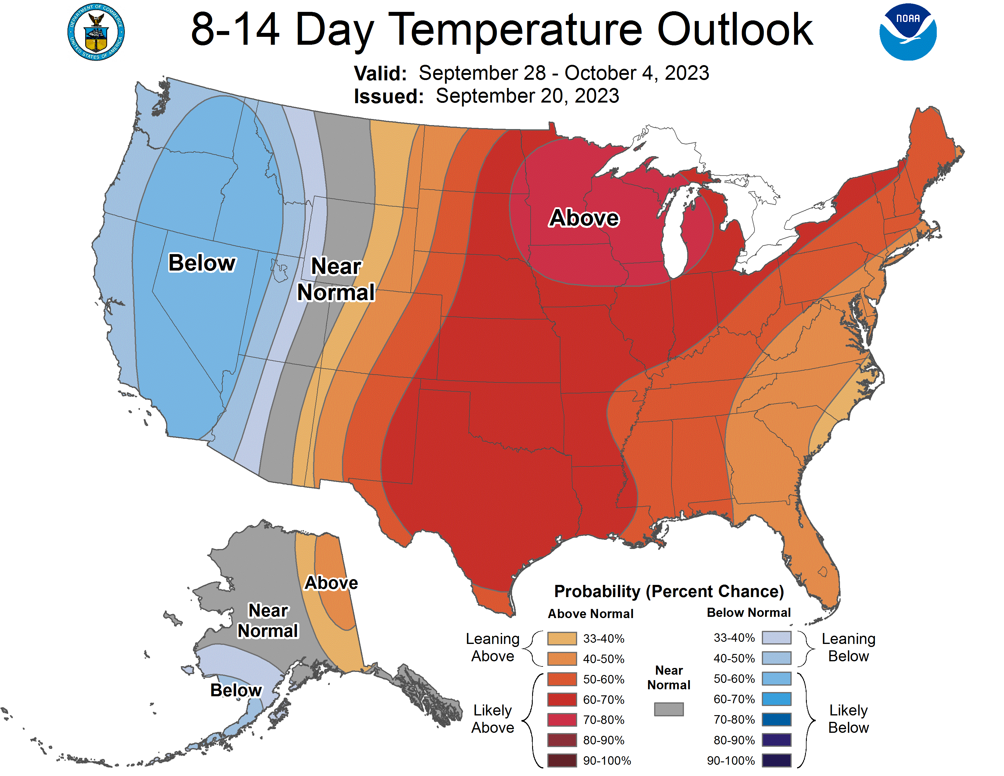
That upper low is expected to cutoff in eastern South Dakota as the subtropical jet weakens and there will be nothing else to "kick it out" until the middle of next week when the next system moves in from the west. That should keep a chance for showers and storms in the forecast into early next week in eastern Nebraska. That other system will enter our region by Wednesday which looks to bring additional chances of precipitation in the eastern half of the state. By later next week a strong trough is expected to enter the western U.S. and keep that region of the U.S. cool and bring more needed rainfall to the Pacific Northwest. Ahead of the trough, warm southerly flow will be the rule in the central U.S. This will keep temperatures seasonally warm and the jackets in the closet a while longer. As of now next weekend appears to be dry with high temperatures in the mid 70's to mid 80's, but a new storm system may be lurking by then if that trough is a little more expedient than currently forecast.
Precipitation and Drought Monitor Update
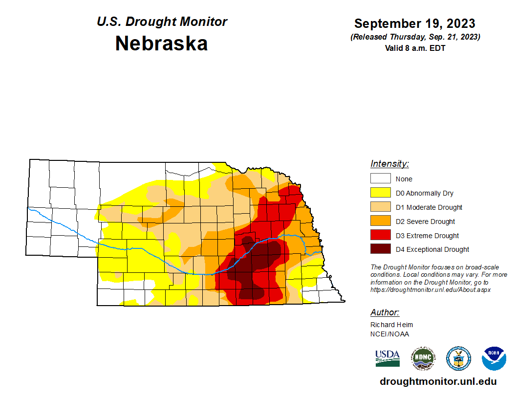
Most of the state has been quite dry over the past 30 days, save for parts of the Panhandle and portions of southern Nebraska. The worst of the dryness has been focused across east central and northeastern Nebraska. CoCoRaHS reveals a broad area from Holt County down to York County and ENE over to Blair picked up under an inch of rain between August 15th and 7:00 this morning. The recent deficits combined with acute longer term precipitation deficits, depleted soil moisture, and historical agriculture impacts, it was enough to push much of York, Seward, Butler, and Polk counties into exceptional drought (D4). Exceptional drought also was expanded into parts or most of Clay, Nuckolls, Thayer, Fillmore, Adams, and Hall counties for the same reasons as further north. An argument could be made that Clay and Nuckolls counties have taken the worst of the beating from the drought this season. Outside the state, drought conditions continue to worsen in other parts of the Midwest. Exceptional drought now encompasses portions of eastern Iowa, southeastern Minnesota and southwestern Wisconsin and a significant portion of all three states are in severe drought or worse. The drought in that part of the Midwest is having a big impact on the level of the Mississippi River and a tough fall for barge traffic appears likely.
Soil Moisture Update
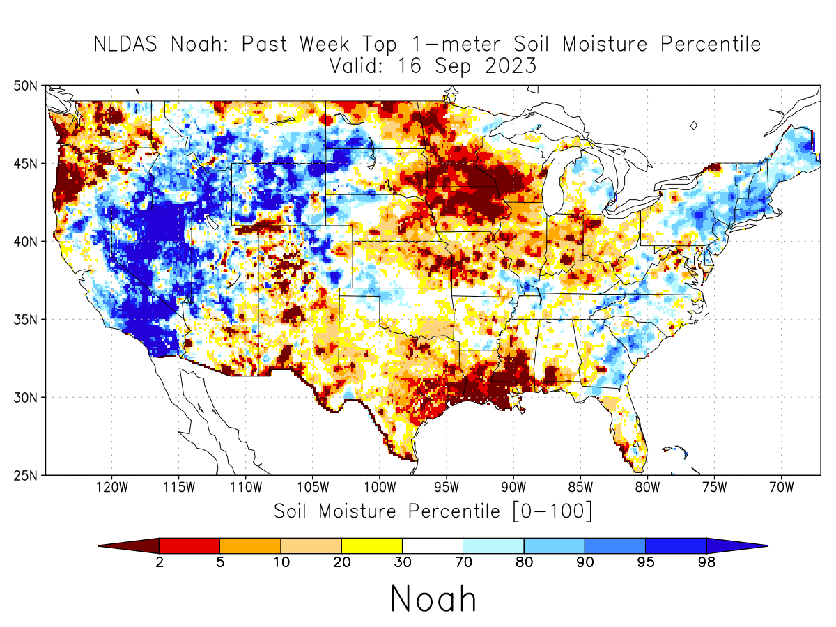
The NLDAS soil moisture product (based on a robust land surface model) shows that most of the eastern half of Nebraska is in the bottom 10th percentile for root zone soil moisture in mid-September. Exception to this is in the far southeastern corner where it has been much wetter this year, as is often the case. The western half of the Sand Hills and Panhanadle generally are around "average" or above the 70th percentile. Keep in mind that a percentile of root zone soil moisture does not necessarily equate to a fraction of available water (likely doesn't at all) nor are these modeled soil moisture products perfect. But they do a reasonably good job at depicting where soil moisture is anomalously deficient and where vegetation may be suffering as a result.
Vegetation and Crop Condition Update
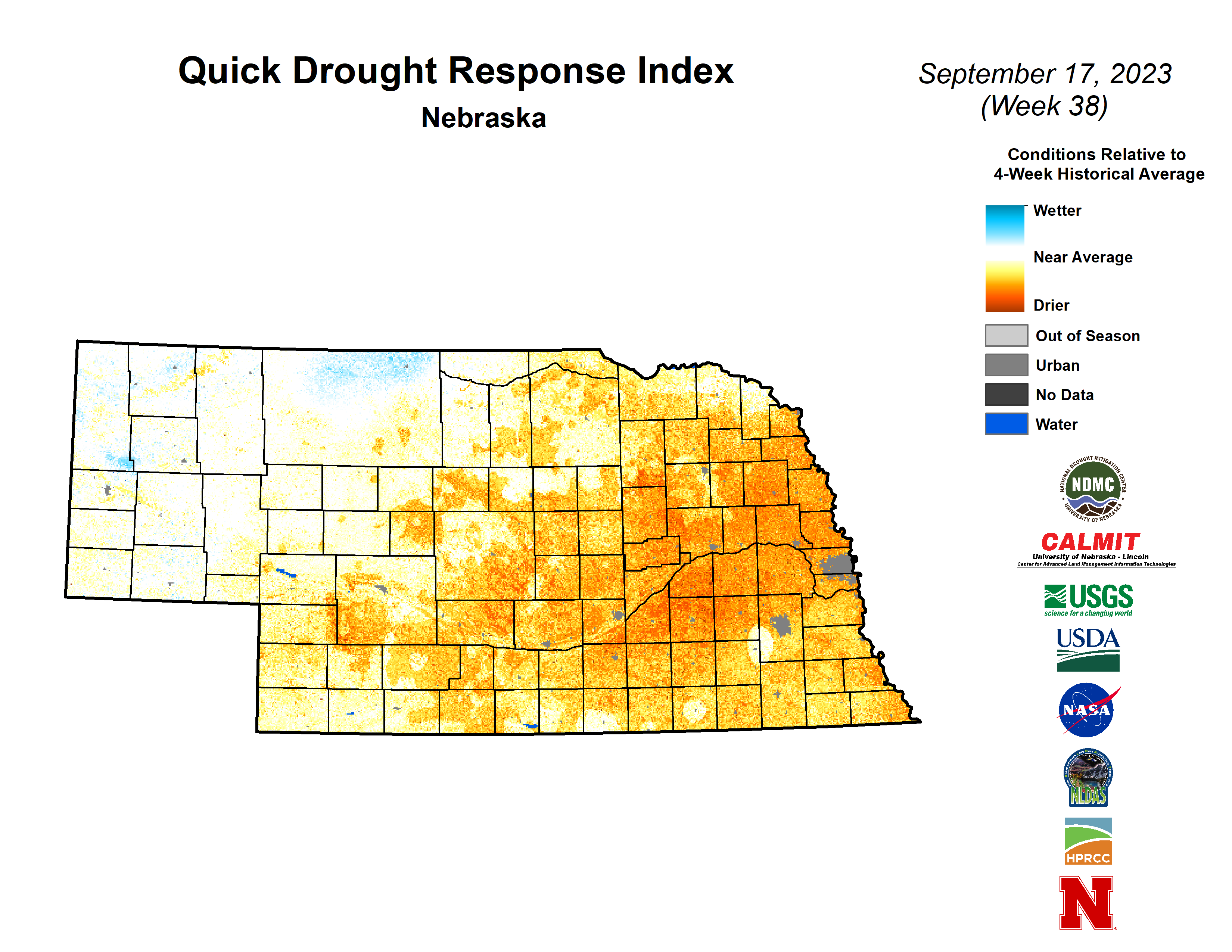
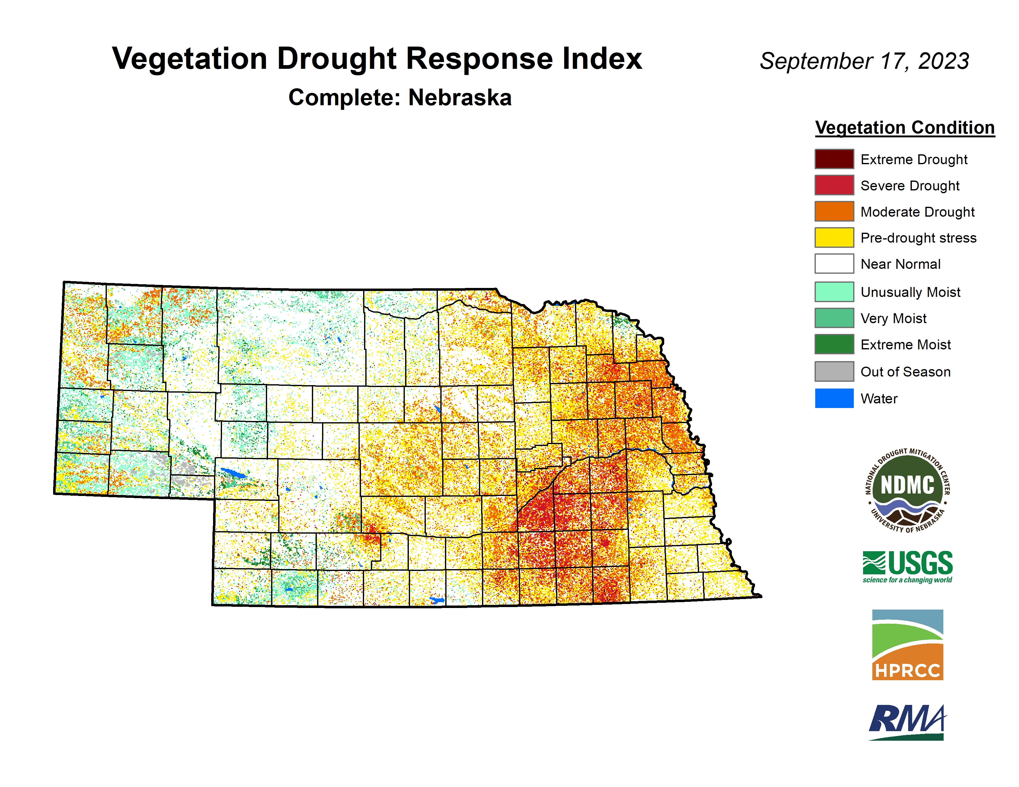
VegDRI continues to show the worst conditions being in south central and east central Nebraska and things aren't too rosy in most of northeast Nebraska either. Some of this is a reflection of lower NDVI values due to the crops maturing early but it is also a reflection of broader stress in the ecosystems. QuickDRI shows the driest areas in the short-term are between Grand Island and Seward and up into northeastern Nebraska. This likely contributed to York, Seward, Butler and Polk counties going back into exceptional drought. VegDRI continues to depict good conditions across the Panhandle, western Sand Hills, and the southwestern corner of Nebraska. This has truly been a rare season where western Nebraska has plentiful moisture and healthy vegetation and eastern Nebraska mostly doesn't.
Corn is at 57% maturity (16% points ahead of schedule) and comes in with a condition rating of 50% good to excellent (G-E) and 27% poor to very poor (P-VP). Soybean is well ahead of schedule for dropping leaves at 72% and came in with condition rating of 47% G-E to 28% P-VP. 27 percent of sorghum was mature and came in with a condition rating of 61% G-E and 13% P-VP. Pasture ratings continue to decline with 32% G-E and 31% P-VP. Hopefully rain in the eastern half of the state in the next week will start to improve those condition ratings.
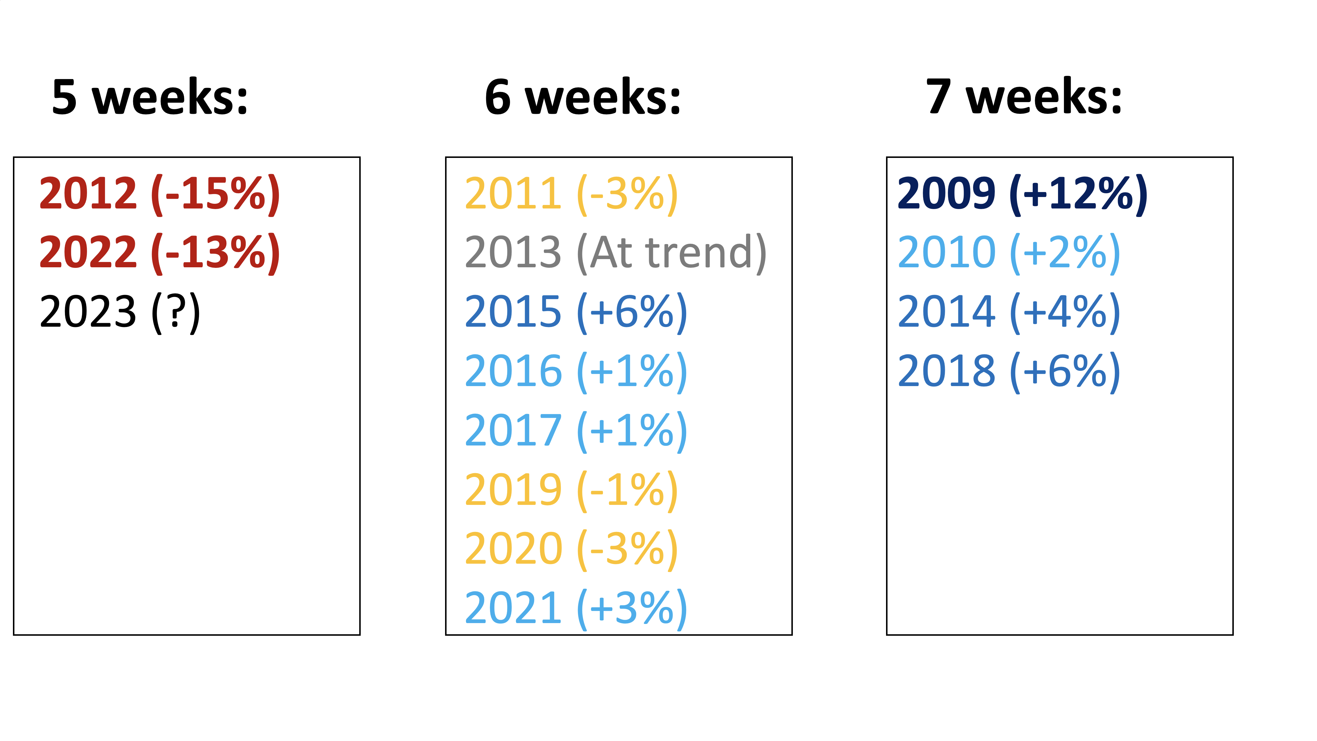
I want to finish up today by talking about the acceleration of this year's corn crop to maturity and what that may mean for yields. Corn in the state typically goes from being >50% dough to >50% maturity (DTM) in six weeks according to USDA NASS. In those years corn has typically been within a few points of trend, with 2015 being a bit of an exception at 6 points above trend (see Figure 7). In the more ideal growing seasons with plentiful mid and late summer precipitation and a lack of extreme heat, that time has been from DTM has been seven weeks and yields generally have been well above trend. The last time we had such a season was 2018. This season has a lot of adjectives that could describe it but ideal is certainly not one of them for most corn growers in the state. With a combination of drought and a late season heat wave, the corn crop really accelerated through the dent stage to maturity and achieved DTM in just five weeks. Since 2009, only 2012 and 2022 had this quick of a DTM. Going back a bit further, DTM was this fast in 2000, 2002, 2003 as well. Of those five years, only one (2003) had a statewide corn yield better than 10 points below trend. Based on this metric, there is roughly an 80 percent chance corn is 10 points or more below trend. There is some chance higher rainfed corn yields in the southeast could offset struggles elsewhere. But between irrigated yields likely being somewhat under trend and the prospect of very low rainfed yields in areas currently in D4, it is hard for me to see how the statewide corn crop achieves 175 bpa this year. I am starting to even wonder if corn yields this year are going to be better than the 165 bpa that was achieved last year. It is not impossible if the combines show consistent -10% against trend for the irrigated corn in D4 counties. This was not necessarily the case in 2012 and 2022 but the conditions going into mid-summer this year were much worse than last year and 2012. So 10 points under trend may be a reasonable estimate. Guess time will tell.
Eric Hunt, University of Nebraska Extension and Nebraska State Climate Office