


Week Ahead Outlook
The next several days will be above average almost everywhere in the state and temperatures will be near record warmth tomorrow through Monday in central and eastern Nebraska. Across western Nebraska, temperatures should be just seasonally warm and not in record territory. In addition to being very warm, we will have a strong breeze from the south for the next several days. This sets the stage for high fire danger, especially across portions of east central Nebraska that have been very dry over the past several weeks and have low amounts of soil moisture and stressed vegetation. We haven't seen as many wildfires across the state this fall as last fall but this weekend may put that improved trend to a test.
A slow moving trough will be entering the western U.S. this weekend and will slowly move east into the central U.S. by Tuesday. This will bring chances of precipitation to western Nebraska early Tuesday and across the eastern half of the state Tuesday afternoon into Wednesday. This is a favorable setup for widespread precipitation with over an inch of rain possible across portions of central and northeast Nebraska. The position of the upper level low and speed is such that the rainfall could be even more robust than this if we are able to tap into adequate moisture from the Gulf of Mexico. Regardless, places in eastern Nebraska that have been very dry in September (e.g., Seward) could be looking at the first significant rain since July or early August.
There are hints in the models that there will be highly amplified flow in the upper levels of the atmosphere in the Northern Hemisphere with a sharp trough coming into the north central U.S. by later next week. If this verifies, temperatures next Friday and Saturday would be in the 50's across most of the state for highs with the potential for scattered showers in eastern Nebraska. If this trough ends up not coming to fruition, which would be what the CPC is favoring at the moment, then temperatures likely will be seasonal to seasonally warm by the end of next week. Regardless the near-record temperatures should be over after Monday.
Precipitation and Drought Monitor Update
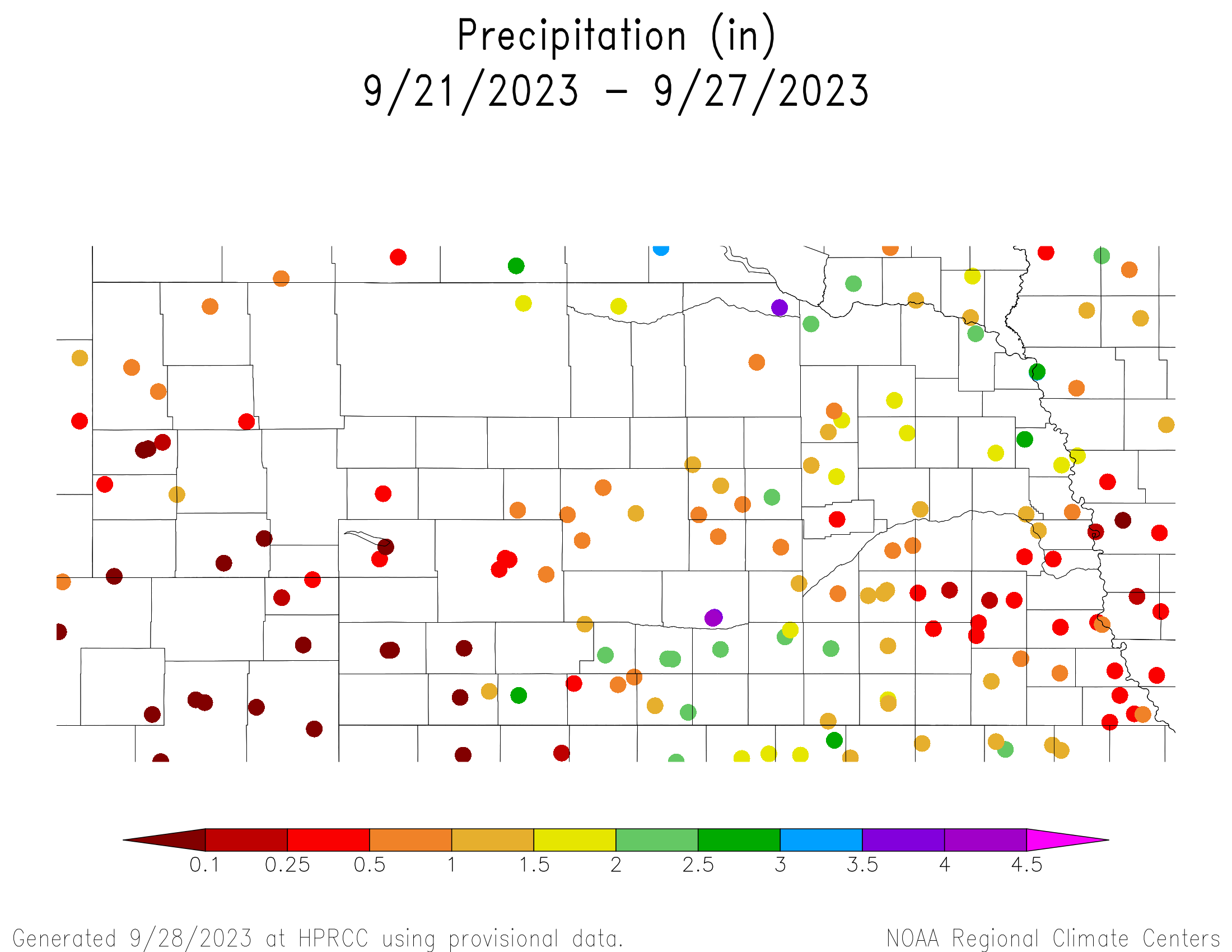
Precipitation was quite robust across much of the south central, southwestern, northeastern sections of the state over the past week. Big winners were Lynch (3.69") and Kearney (4.06") but many areas in those sections of the state saw between 1.5-3". This precipitation was adequate enough to warrant improvements on the U.S. Drought Monitor across southern Nebraska from McCook over toward Hastings and across Brown, Rock, Boyd, and Holt counties. There was also a pocket of a 1-category improvement in Dakota County as well.
Precipitation was much more spotty in the Panhandle and far southwestern Nebraska, with some places not picking up anything. Farther to the east, most of the southeastern quadrant of Nebraska picked up some moisture last Thursday night from a weakening mesoscale complex (that soaked places further west) but in general, amounts were under half an inch. Some of the I-80 corridor from York and Geneva over to the western half of Lancaster County has been very dry this month with amounts generally under an inch. Lincoln will have its 12th driest September on record, putting it in good company with 2021 which came in at 12th driest. Last year wasn't great with only ~ an inch either.
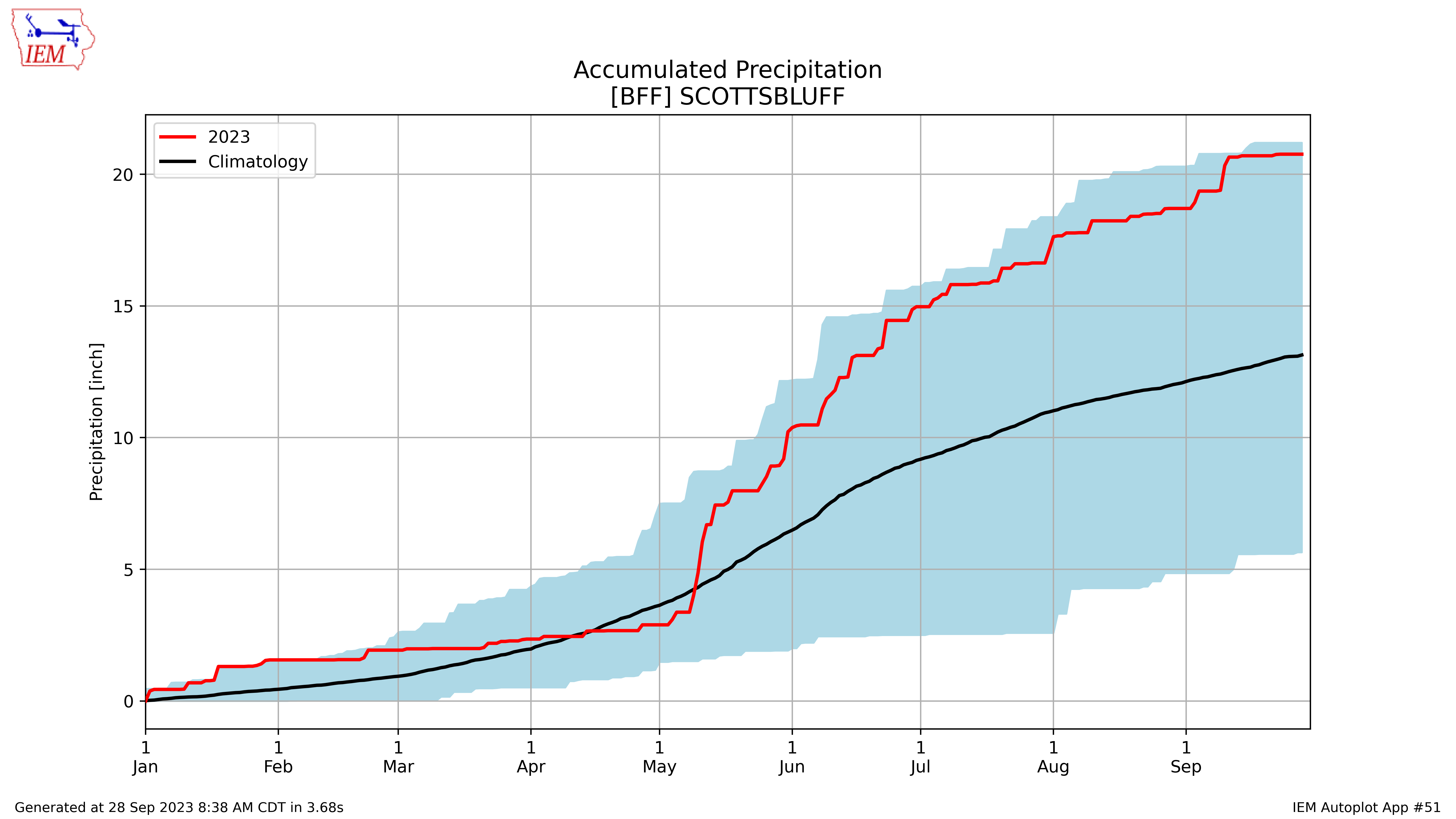
When all is said and done in 2023, we will likely look back at the relative extremes of precipitation that have existed and to some degree, persisted, across the state this year. Much of the prime irrigated territory of central and eastern Nebraska from Hastings to York to Columbus is having one of its driest years on record. For example, Columbus has received around 12" of rain this year so far, which is close to the lowest ever through late September. Conversely, it has been a very wet year across much of western Nebraska. Scottsbluff has had more than 20", more than most places in eastern NE have had this year, more than double the total for all of 2022, and near a record maximum for the year-to-date. Scottsbluff could achieve its wettest year ever with 3-4 more big storms between now and New Year's Eve.
Soil Moisture and Vegetation Update
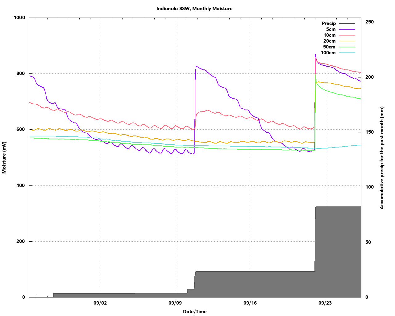
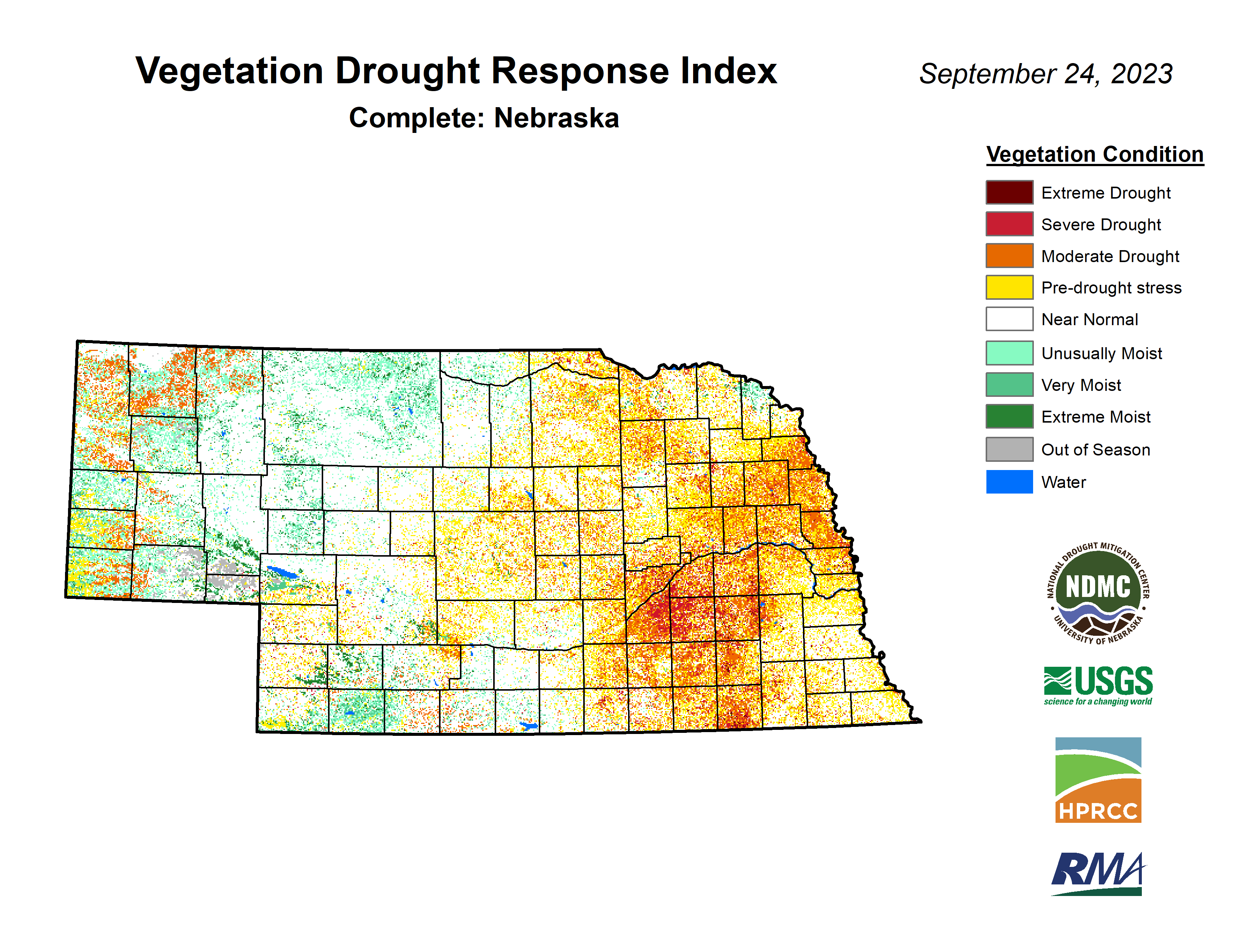
There is good news and bad news in this section. The good news is much of northeastern and central Nebraska saw meaningful improvements to soil moisture in the top foot of the profile. This was reflected in the raw soil moisture data at Mesonet sites (e.g., Indianola) and in modeled products like SPoRT LIS. There is still a shortage of deeper moisture but recharging below 25 cm is a good step in the right direction. The bad news is parts of east central and southeastern Nebraska are not only short on deep moisture, there isn't much in the top either. This means vegetation is more stressed than usual (e.g., see VegDRI map in the images section) and more conducive to burning. The wildfire risk is a concern over the next few days with the heat, lower relative humidity and breezy conditions and will be most acute in places where soil moisture is most deficient. A Red Flag warning may be issued by the local Weather Service offices for portions of the state over the weekend so be mindful of their guidance.
Crop Condition Update
Corn is at 70% maturity (6% points ahead of schedule) and comes in with a condition rating of 49% good to excellent (G-E) and 29% poor to very poor (P-VP). Corn harvest is progressing nicely at 15%, which is 5 points ahead of the 5-year average. Soybean is ahead of schedule for dropping leaves at 86% and came in with condition rating of 47% G-E to 28% P-VP. Soybean harvest is 14% complete. 45 percent of sorghum was mature and came in with a condition rating of 63% G-E and 11% P-VP. Winter wheat planting is also ahead of schedule this year with 60% planted, 9% above the 5-year average. Pasture ratings improved some this week with 40% G-E and 23% P-VP.