


Fire danger at critical levels
Fire danger is at critical levels across the eastern two-thirds of the state this afternoon and will remain elevated through tomorrow. Soil moisture levels are very low across the entire region, there is plenty of dormant grasses and dry leaves for fuel load, and relative humidity is low. Please be extremely careful. Conditions should improve slightly tomorrow and will be better by this weekend.
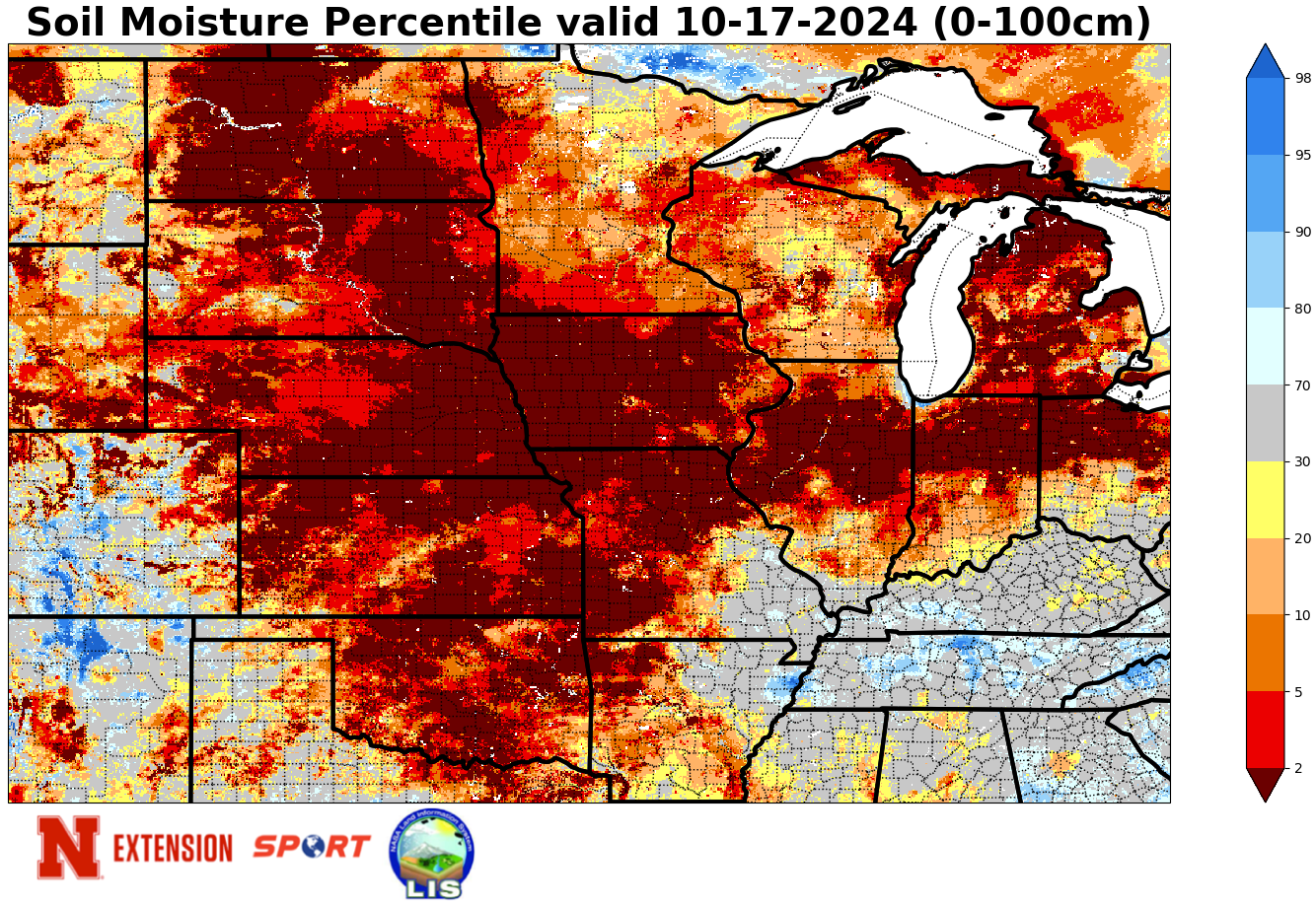
Three consecutive weeks of no rain
In proper Jeopardy style, the question in the title this week is the appropriate response to the answer: "This hasn't happened anywhere in Nebraska in three weeks." Yesterday marked what is effectively the third consecutive week without precipitation in the entire state. That is thankfully going to change in the next 24-48 hours (more on that later). But another week with no precipitation has led to further worsening of drought conditions across the state. We now have drought covering over 80 percent of the state with severe drought covering almost 50 percent of the state. Furthermore, severe drought (D2) is present in portions or all of 56 counties across the state and seven counties have been in D2 or worse for eight consecutive weeks. The southwest corner of the state is technically free of drought still but was downgraded to abnormal dryness on this week's map. If you have drought impacts to report, we would appreciate your feedback and you can use the National Drought Mitigation Center's Condition Monitoring Observer Report (CMOR) system to report impacts.
Yield impacts to crops seem to be minimal or modest compared to what they would have been had this started earlier in the season. But soybean moisture levels are very low- hearing a lot of 6 to 8 percent moisture contents the past few weeks from folks who have been harvesting. Similar story for corn, which has dried down very quickly with some moisture contents down around 11 percent.
Rain chances
The good news is that for the first time in ages there are chances for precipitation across the state. A cold front will moving into western Nebraska tonight and this will bring chances of precipitation and much cooler temperatures for places like Scottsbluff and Alliance. Highs may struggle to get above 50 in parts of the western Panhandle tomorrow. Then our attention turns toward an upper level low that will move into the southwest U.S. and subsequently get cut off from the main flow, which will be up in Canada. Areas to the east and northeast of the upper level low will be in a favorable spot for precipitation thanks to persistent rising motion. This includes the western third of the state starting tomorrow evening into Saturday morning. Amounts up to an inch may be possible in southwest Nebraska with most of western NE seeing a reasonable chance of getting 0.25" over the next 60 hours.
The upper level low gets booted out into the central Plains by Monday morning, which will bring reasonable chances of precipitation to the eastern half of the state. The SPC does not have us in a risk for severe weather at the present time but thunderstorms will be possible during the day on Monday in eastern Nebraska. Moisture return isn't optimal and this isn't an overly potent storm. So, this is not likely going to be a significant rain maker for the Western Corn Belt. But any precipitation at the moment is welcome and most places in the eastern half of Nebraska should get between a tenth and a quarter of an inch. Areas south of the Platte have a shot at getting upwards of a half inch according to the most recent ECMWF ensemble. Not drought busting rains by any means but at least it would reduce the wildfire risk for a while.
Tranquil Weather
The remainder of the week looks quiet and tranquil after the upper low exits on Monday night. A weak cold front will move through the state Tuesday afternoon into early Wednesday, which will bring a bit cooler temperatures and a breeze from the northwest on Wednesday. No precipitation expected. Fire danger will be elevated on Wednesday if rain doesn't materialize in the next several days. Otherwise, expect plenty of sunshine and high temperatures to be mostly in the low to mid 70's next week. Subfreezing temperatures will be possible in western and north central NE on Thursday morning. But in general low temperatures next week will be in the 30's (western NE) and the lower 40's in eastern and southern sections of the state. There is some hint for much colder air invading the state around Halloween but above average temperatures seem a safe bet for at least another 10 days in this region. The CPC shows the eastern sixth of Nebraska and points east as having above average chances for precipitation in the 8-14 day period. This is not a safe bet but the latest ECMWF does suggest a trough digging into western U.S. in 10 days, which would possibly help initiate a surface low in the central U.S. that could help produce precipitation from eastern Nebraska to the Great Lakes. Worth hoping that solution is right.
Football forecast
Conditions in Bloomington, IN will be ideal for football. Sunshine and temperatures getting up to around 70 by the fourth quarter. There should be almost no wind so no excuses for poor kicking! Neither Camille or I are very confident in the outcome... but we think Nebraska spent the bye week working out some of the offensive kinks. Our projections:
Camille's prediction: Nebraska 32 Indiana 27
Eric's prediction: Nebraska 27 Indiana 24
Temperature and Precipitation Summary
Attached are pdf's containing the maximum/minimum temperature, average temperature, number of days with maximum temperatures ≥95F, minimum temperatures ≥70F, degree days, and total precipitation for each Mesonet station over the period from October 6-12. Soon we will be transitioning to winter statistics.
Below are the temperature and precipitation extremes around the state over the past week:
Maximum Daily High Temperature: 92, Tecumseh 1 S
Minimum Daily High Temperature: 54, Fordyce 4NW Mesonet
Minimum Daily Low Temperature: 19, Broken Bow Municipal Airport
Maximum Daily Low Temperature: 58, Gretna
Weekly Precipitation: 0.00", No rain for anyoneEric Hunt, University of Nebraska Extension
Camille Shifrin, Nebraska State Climate Office


