Main Highlights
The average temperature for the state of Nebraska in April 2025 was 49.3°F, which was 1.6°F above the 20th-century average and the 44th warmest overall. Nebraska's average precipitation in April 2025 was 0.41 inches, which is 1.12 inches below the 20th-century average and the 17th driest on record.
Below are relevant maps from NCEI's Climate at a Glance.
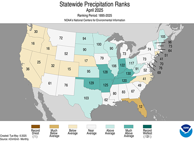
Figure 1. April 2025 statewide precipitation ranks
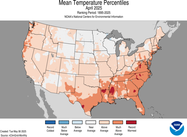
Figure 2. April 2025 average temperature percentiles
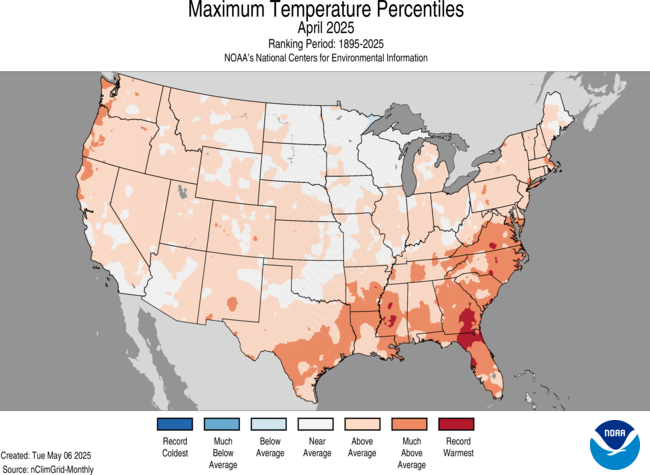
Figure 3. April 2025 maximum temperature percentiles
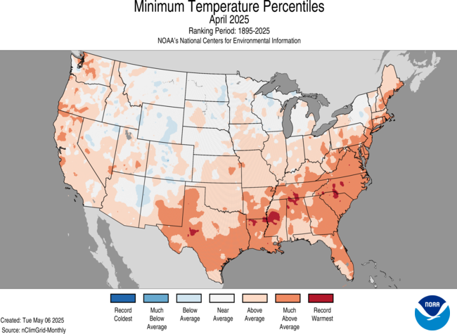
Figure 4. April 2025 minimum temperature percentiles
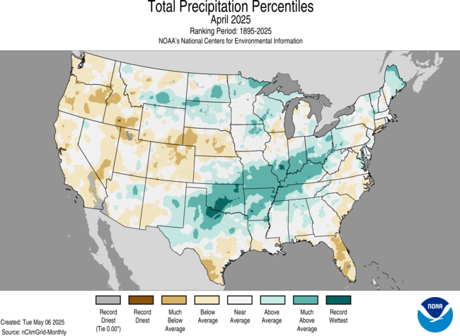
Figure 5. April 2025 total precipitation percentiles
Moisture Inequality
Most of the state saw below average precipitation in April but parts of eastern Nebraska were right at or slightly above the long-term average while most locations in the Panhandle and several places in central Nebraska were well below the long-term average. The Panhandle climate division averaged 0.63" and both the south central and central climate divisions averaged under an inch.
Areas that did see slightly above average precipitation for the month were areas that had most of it fall in short periods of time with heavy thunderstorms. Maximum precipitation for the month of April occurred in the eastern half of Omaha where a few CoCoRaHS observers reported over 4", though much of that fell in less than two hours on the evening of April 24th. Areas around Fairbury also received almost 4" during the month of April but most of that also fell in a shorter period on the 24th. Significant precipitation from severe thunderstorms also fell in parts of Sheridan, Cherry, and Boyd counties on the 27th, which brought monthly totals around or a bit above average.
Severe Storms
April was a dry month and severe storms were not a frequent threat. But the few days that did have severe weather were impactful. The first was on the evening of Thursday, April 17th when several tornadoes occurred in east central Nebraska as a result of a "triple point" of a dry line, surface low, and cold front. 11 tornadoes were reported that evening with the strongest tornado (EF-3) occuring between Bennington and Ft. Calhoun. Large hail also was a big problem that evening. The afternoon and evening of the 24th brought a few tornadoes to the southeast qudrant of the state and a huge supercell in the Sand Hills on the 27th produced several tornadoes.
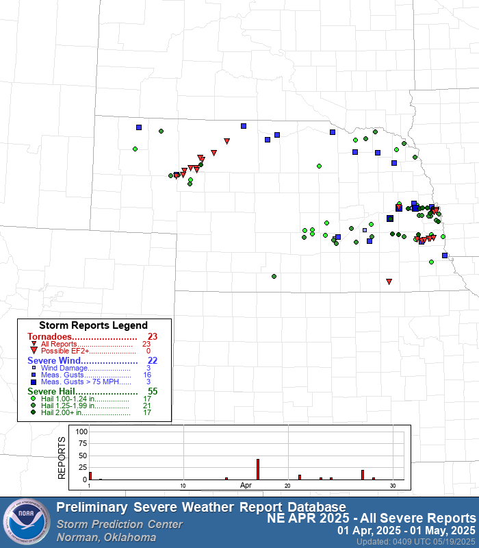
Figure 6. April 2025 storm reports for the state of Nebraska
Drought Update
Drought expanded and/or intensified across a good portion of the state with the dry conditions in April. The area with the most significant change was centered around Grand Island with a 2-category degradation from abnormal dryness (D0) to severe drought (D2). Degradation also occurred in the southwest and southeast corners of the state and much of central and parts of east central Nebraska saw a 1-category degradation to varying levels of drought severity.
A pocket of southeast Nebraska focused on Thayer and Jefferson counties saw a 1-category improvement to abnormal dryness. Other small pockets around the state saw minor improvements following late-month rainfall.
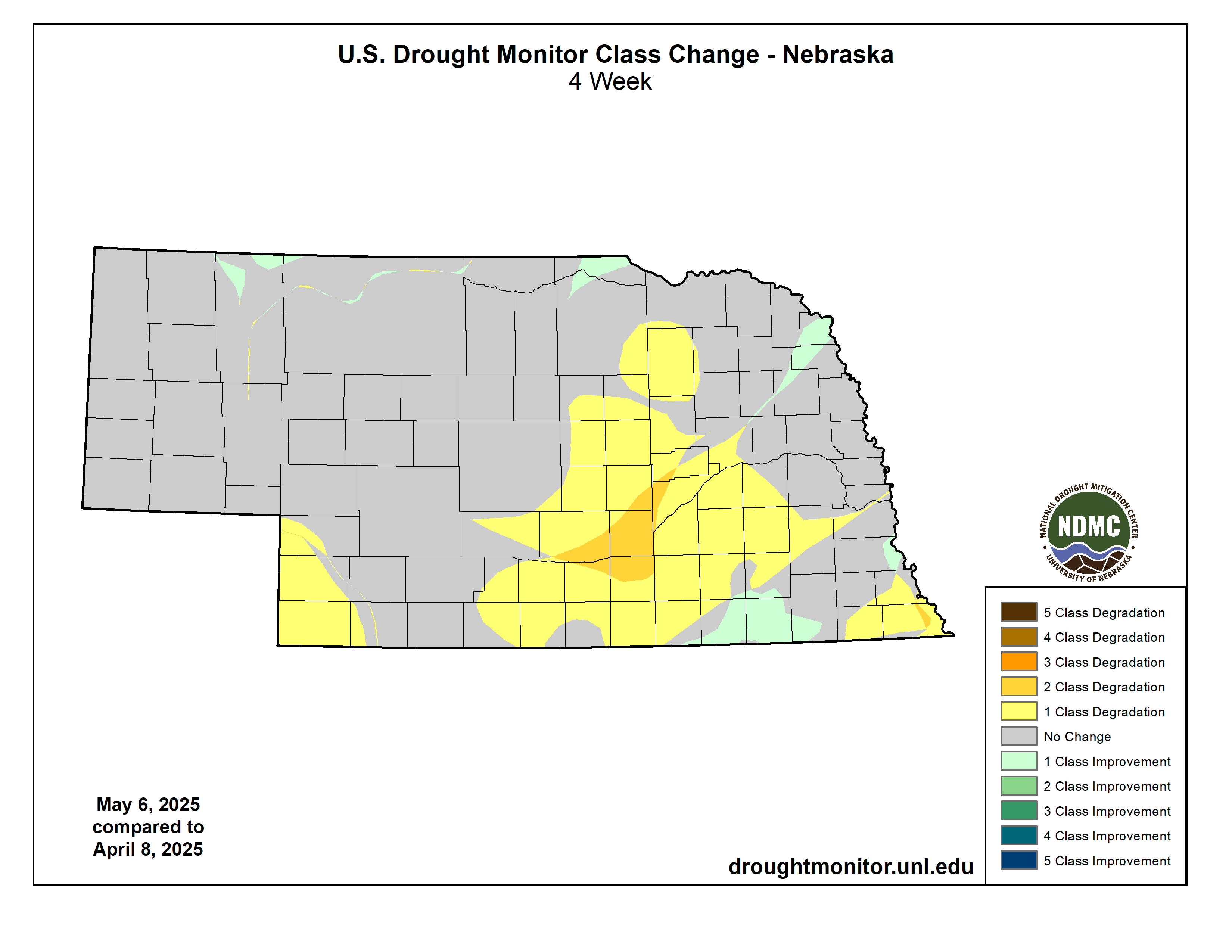
Figure 7. Changes in Drought Monitor category
Temperature and Precipitation Extremes
The Mesonet summary contains the absolute maximum and minimum temperatures, the average temperature, the number of days with subfreezing high temperatures and subzero low temperatures, the number of growing-degree days, the average soil temperature, and the average cattle comfort index.
Here are the temperature and precipitation extremes around the state:
Maximum high temperature: 93°F, Tekamah
Minimum high temperature: 32°F, Bushnell 15 S
Maximum low temperature: 62°F, Falls City Brenner Field
Minimum low temperature: 11°F, Agate 3 E
Maximum precipitation: 4.05", Omaha 2.9 W
Minimum precipitation: 0.07", Arcadia


