Storm chances and initial cool down
Current 500-mb analysis shows Hurricane Erin off the east coast, a stout ridge over the southwest responsible for intense heat in that region, and a sharp trough moving into Saskatchewan and Manitoba. In our area, we are still under the influence of ridging to our southwest and temperatures will remain warm this afternoon, especially in western Nebraska where mid to upper 90's will be common.
The aforementioned trough will be moving southeast and a surface cold front will be entering the state by later tonight Scattered showers and storms will be possible in the Panhandle and northwestern section of the Sand Hills. The front should make some progress tomorrow, likely getting to the Highway 30 corridor by later in the day. Areas to the north will be cooler while another relatively warm and muggy day (southeast NE) will be the rule south of it.
Thunderstorms will be possible tomorrow afternoon and evening around the front and the SPC does have the entire state in the marginal risk for severe weather. Storms that form will be relatively fast moving to the south-southeast so excessive rainfall is not a huge concern. Biggest risk would be small hail. Storms will be possible across western sections of Nebraska
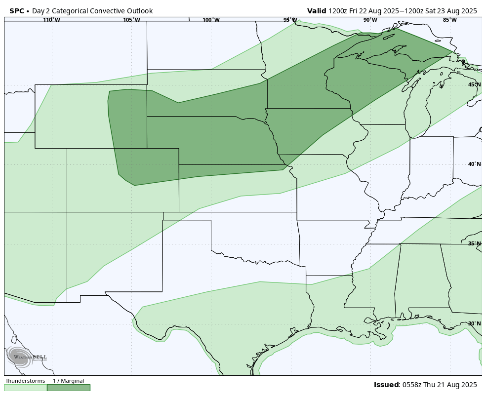
Figure 1. SPC severe risk tomorrow
Saturday should be mostly dry across the state and noticeably cooler with highs in the upper 70's to lower 80's. Another shortwave will be moving into the western portion of the state on Saturday night into Sunday morning. This will open up chances for precipitation across the Sand Hills into south central and possibly southeastern Nebraska on Sunday morning. Northeast sections of the state likely to remain dry. Total precipitation expectations from the WPC over the several days ranges from around an inch for Sidney and Imperial to a tenth of an inch for much of central Nebraska. Note that it is possible that much of that area has a chance of storms tomorrow afternoon and again on Sunday morning, so those amounts may be too low.
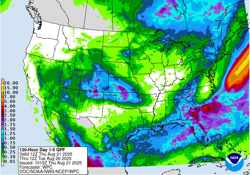
Figure 2. WPC precipitation projections through next Tuesday morning
Cool week
With a deep trough over the eastern U.S. most of next week, we will remain in northwest flow and this will help reinforce cold advection into the region through most of next week. High temperatures likely will be below 80 statewide through Wednesday and may remain below 80 for the most of the week in much of eastern Nebraska. We also will be getting much drier air into the eastern half of the state. This will allow for temperatures to drop to levels we haven't seen since early June, with lows sub-50°F on Monday and Tuesday mornings possible as far south as Highway 6/34. Temperatures may even dip into the lower 40's across portions of north central Nebraska. This likely will be the coolest week we have had in late August in this region in several years.
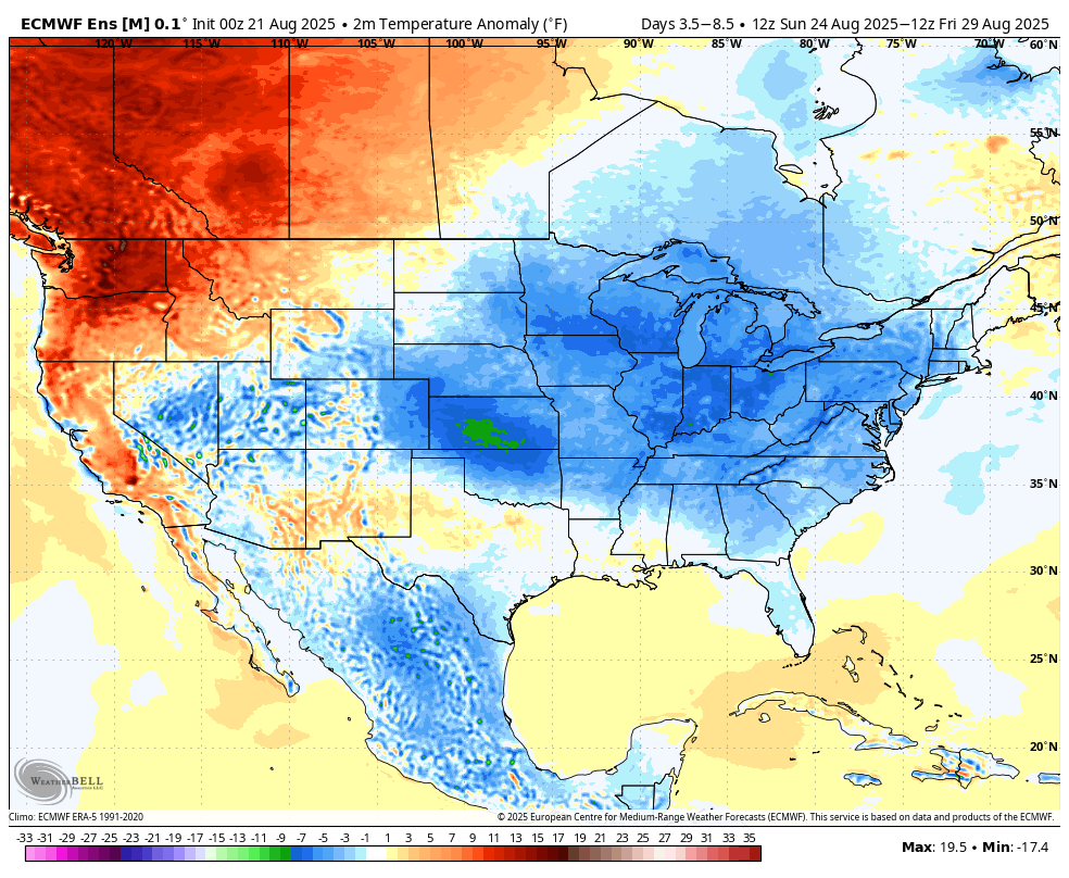
Figure 3. Temperature anomalies next week
Rain chances later in the week
Most of the eastern half to two-thirds of the state should remain dry for the first half of the work Western Nebraska will be in more favorable area to have chances for precipitation on Sunday night into Monday and possibly again into Tuesday. Heaviest rain will likely be to the south in Kansas and northern Oklahoma along a near-stationary frontal boundary early in the week.
Bigger uncertainty comes later in the week when a system comes into the Central Plains. Some model solutions build the southwest ridge further north and take more of the vorticity/energy closer to us and some keep these things further south, which would put the southern half of Kansas, Oklahoma, and Missouri in line for more rain. WPC is favoring the latter while the AI runs are a bit further north.
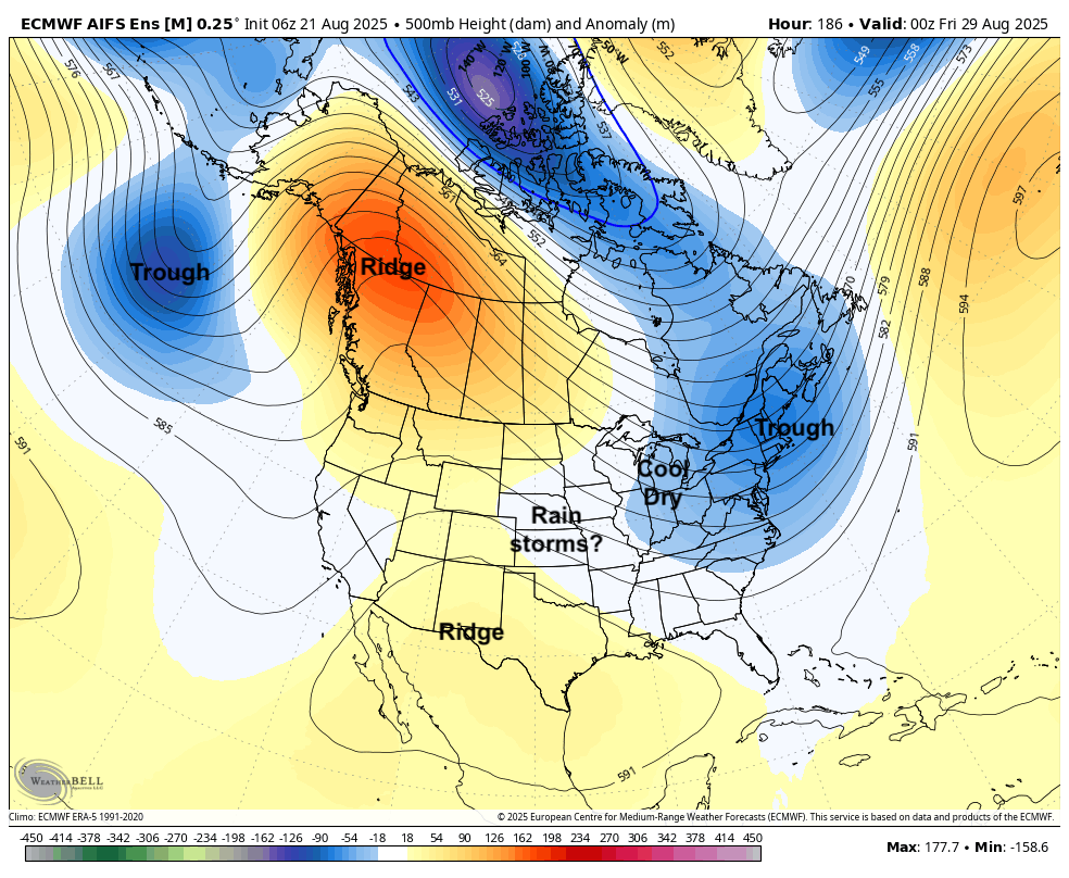
Figure 4. Projected 500-mb height anomalies next Thursday evening
In plain English, this means that we may get a decent shot at rain on Thursday into Friday, particularly in the southern half of the state. There appears to be a better shot of significant precipitation to our south along the I-70 corridor, which could make the game in KC next Thursday night interesting depending on timing of rain/storms.
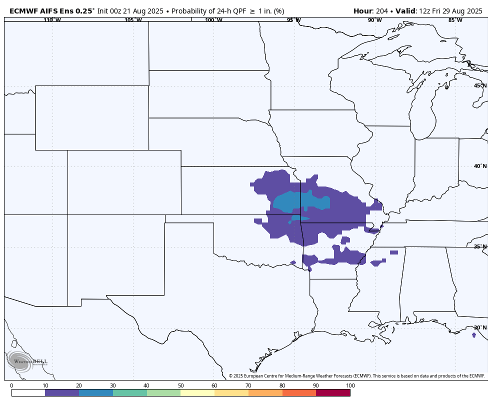
Figure 5. ECMWF probability of 1" of precipitation next Thursday and Friday morning