
Soil moisture decline
This weekend featured a combination of hot temperatures and persistent strong winds, especially for central and eastern sections of the state. This combination led to a rapid decline in soil moisture according to NASA's SPORTLIS. Check out the difference in soil moisture percentiles across south central and eastern Nebraska between Figures 1a (near-current) and Figure 1b (last Thursday).
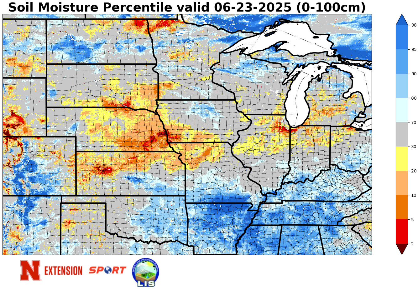
Figure 1a. Current soil moisture percentiles
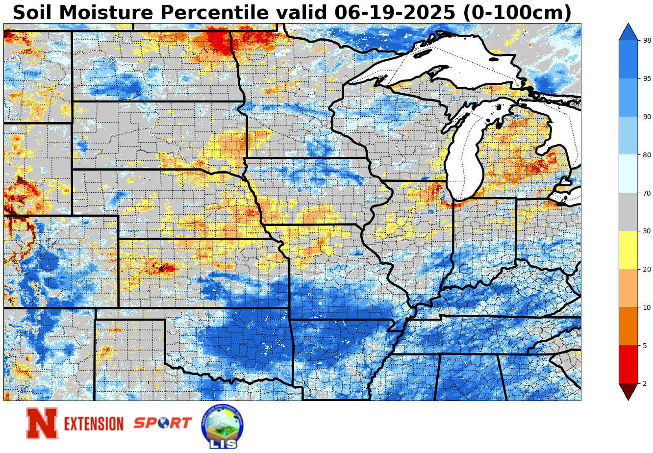
Figure 1b. Soil moisture percentiles as of last Thursday morning
Potential ET
The reason for the soil moisture decline was that the combination of wind and heat maximized potential ET. There are various ways to calculate potential (or reference) ET but for purposes of this article, the standard Penman-Monteith method was used and assumed alfalfa for ground cover (this is common). Based on those assumptions, almost every Mesonet site had at least 1.5" of potential ET over the three-day period ending last night. Some sites were over 2 inches and the Indianola 8 SW site near McCook had over 2.5".
This does not mean that the actual ET was that high over a corn field as most corn around the state is not far enough along for the crop coefficient to be 1.0 or higher just yet. Nevertheless, even a more conservative estimate of 0.7 would yield 1" plus of ET for all but the Panhandle sites that were considerably cooler on Sunday thanks to getting the front first. In other words, there's a reasonably good chance most fields lost an inch-plus of moisture this weekend. We will need the rain that is coming in the coming days to replenish what we lost or this weekend may well have been the beginning of a flash drought for the Central Plains and Western Corn Belt.
The table below shows the accumulated potential ET by site.
| Mesonet Station: | Total Pot ET |
| Alda 5NW | 1.863 |
| Alliance 6NW | 1.389 |
| Arthur 8S | 1.558 |
| Axtell 5NE | 1.867 |
| Big Springs 6SE | 1.838 |
| Big Springs 8NE | 1.667 |
| Broadwater 7N | 1.26 |
| Bushnell 12SE | 1.521 |
| Central City 3W | 1.694 |
| Concord 2E | 1.877 |
| Cook 4SW | 1.71 |
| Decatur 7S | 1.814 |
| Dickens 1NE | 1.774 |
| Eagle 3NW Beta | 1.707 |
| Emmet 2E | 1.397 |
| Enders 10SW | 1.973 |
| Firth 3N | 1.71 |
| Fordyce 4N | 1.878 |
| Gothenburg 2NW | 2.063 |
| Guide Rock 3E | 1.607 |
| Harrisburg 1N | 1.64 |
| Harvard 4SW | 1.611 |
| Hayes Center 3N | 1.889 |
| Holdrege 5N | 1.925 |
| Indianola 8SW | 2.51 |
| Kearney 3E | 2.061 |
| Keystone 4W | 1.808 |
| Leigh 1W | 1.759 |
| Lexington 4S | 1.853 |
| Lincoln 1500 N 45th | 1.647 |
| Long Pine 20S | 1.566 |
| Memphis 4N | 1.576 |
| Memphis 5N | 1.598 |
| Merna 2SW | 1.451 |
| Naper 12SW | 1.753 |
| Nebraska City 3W | 1.742 |
| North Platte 3SW Beta | 1.503 |
| Oakland 4W | 1.773 |
| Ord 2N | 1.801 |
| Oshkosh 6N | 1.607 |
| Overton 6SE | 1.867 |
| Pierce 2SW | 1.722 |
| Plattsmouth 2SE | 1.538 |
| Rulo 5SW | 1.502 |
| Scottsbluff 2NW | 1.34 |
| Scottsbluff 6NW | 1.529 |
| Shelton 2SW | 1.831 |
| Sidney 2NW | 1.522 |
| Smithfield 2E | 1.827 |
| Valparaiso 6NW | 1.515 |
| Walton 5NW | 1.682 |
| Whitman 5NE | 1.146 |
| Wilber 1W | 1.775 |
| Winslow 6E | 1.665 |
| Wood River 5SE | 1.684 |
| York 2W | 1.347 |


