Meteorology setup
A vigorous jet was apparent on the 12Z analysis last Wednesday from the Southern Plains into the Midwest with an upper level low centered over northern Kansas. There was impressive upper level divergence with the storm system, which led to rapid deepening of the surface low as it moved into northeast Kansas and northwest Missouri during the morning hours. With higher pressure building in from the north and west, it meant a very tight pressure gradient across Nebraska.
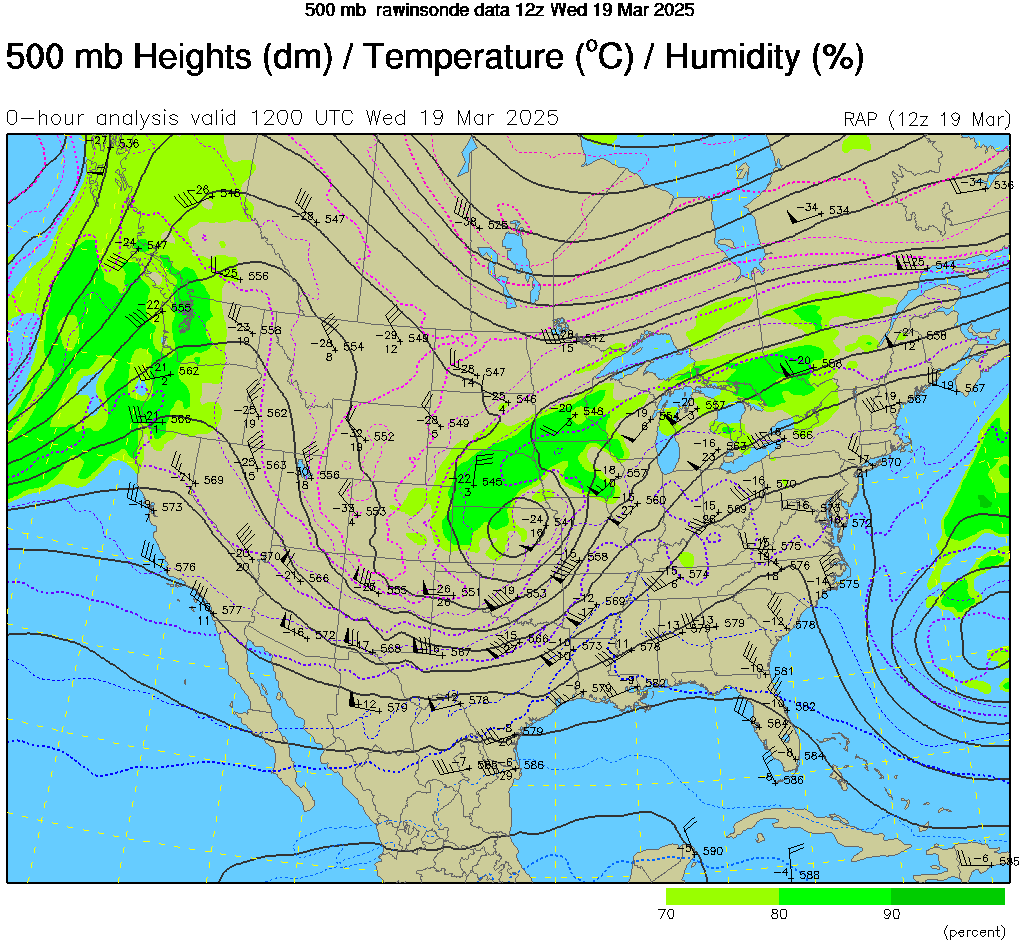
Figure 1. 500-mb map from 12Z last Wednesday morning
At the surface a strong cold front had started moving through the state on Tuesday and by late afternoon, there was a sharp temperature gradient between the northern Panhandle where temperatures were below freezing and southeast Nebraska where temperatures were in the 70's. By midnight on Wednesday, the front had passed through the entire state, and winds were strong from the north everywhere.
Wind
The result of the aforementioned tight pressure gradient was very high wind speeds, with most of the state having wind gusts over 50 mph and several sites having wind gusts over 60 mph. Both Hastings and Lincoln managed gusts over 70 mph. The Wahoo and Fremont sites lost power early in the morning so we don't have accurate wind gust measurements for that area unfortunately. The combination of high wind speeds and heavy snow rates meant that visibility was very poor- under a quarter mile in many cases and near-whiteout conditions in some cases between Lexington and Lincoln. The sustained high wind speeds also led to a significant number of snapped power poles with over 150,000 customers without power at one point. Thousands were still without power as of early this week. The damage was sufficient enough for Governor Pillen to declare 21 counties in the southeast quadrant of the state a disaster area (see related links).

Figure 2. Peak wind gusts last Wednesday
Moisture
The good news is the storm brought ample moisture to much of south central and eastern Nebraska and some moisture to almost everyone. Precipitation started as rain before the transition and in eastern Nebraska, where instability was greatest, thunderstorms with rain, hail, and sleet were common between midnight and the pre-dawn hours. A look at the radar loop on the National Weather Service summary shows the higher reflectivity from the mix of sleet and hail during the early morning hours. Total precipitation amounts of over half an inch were common from Araphoe and Lexington northeast into the Sioux City metro area. Amounts of an inch were common in east central sections of the state and pockets of 2 inches fell between Seward and David City.
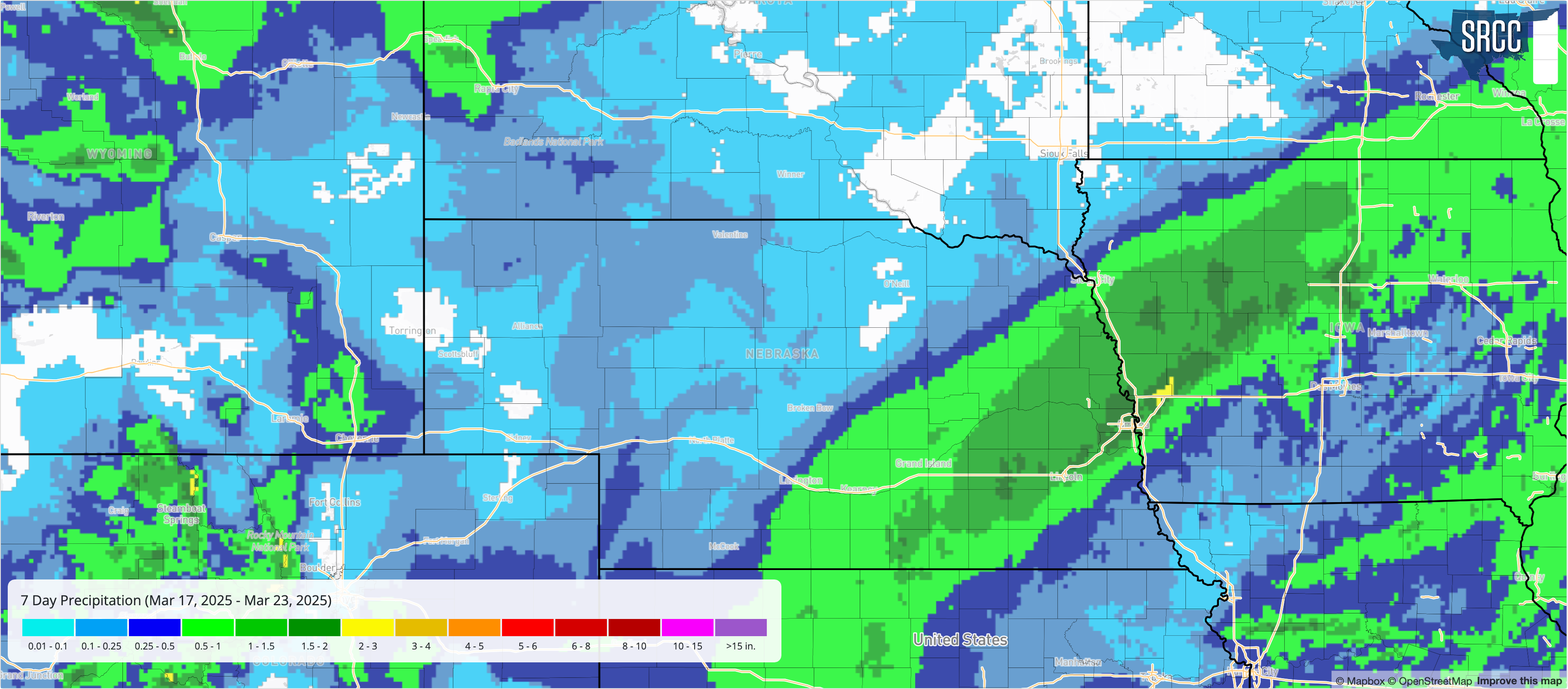
Figure 3. Total precipitation from last week's storm
Precipitation amounts dropped off significantly in far southeast Nebraska where the dry slot was prominent in the morning hours on the 19th and between Lexington-Kearney-Ord and the western half of the Sand Hills. Parts of southwest Nebraska managed around a quarter inch of moisture but most of western and north central Nebraska had precipitation amounts around a tenth of an inch or a little less.
Snow
As the storm system moved east and areas got on the back side of the system, it was sufficiently cold enough to produce all snow. Snow fell in the overnight hours in western Nebraska and transitioned to snow during the early morning hours further east. Amounts of 1-2" were scattered in western Nebraska with some locations picking up no snow at all. Given the position and makeup of the storm, snowfall amounts of over 4" were generally concentrated in a southwest to northeast band between Red Cloud and Superior in south central Nebraska to Wayne and Macy in northeast Nebraska. Highest snowfall amounts of 10-12" were around York with broader area picking of east central picking up 6". Snowfall decreased sharply to the southeast of Lincoln, with only minor accumulations falling in Auburn, Pawnee City, and Salem.
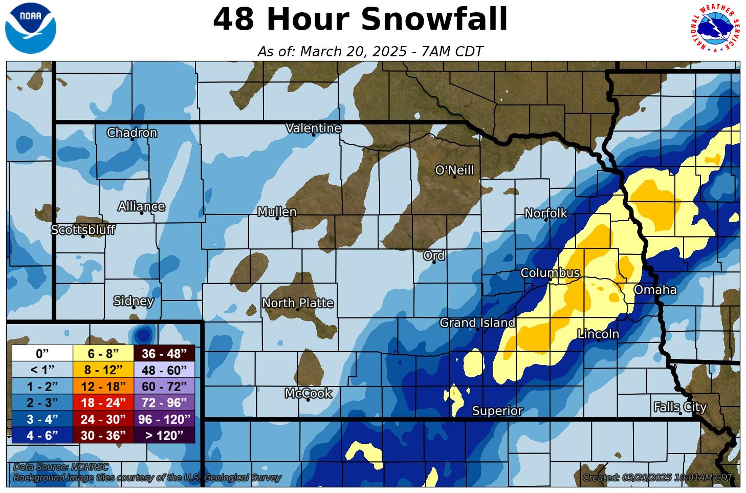
Figure 4. Total snowfall from last week's storm


