Mild and breezy
A look at current upper air analysis shows strong zonal (west to east) flow over the U.S. with a weak shortwave disturbance entering the Northern Plains region. At the surface, high pressure is to our east and winds are relatively breezy from the south and southeast for most of us. Winds will remain elevated throughout the day and will shift to the west or west-northwest through the day as the shortwave passes to the north and east. This downslope component will help temperatures get into the 60's for most of us, though the extensive cloud cover associated with the shortwave may keep temperatures down a bit.
Similar story tomorrow with breezy winds from the WNW for most of us but most places will see more sunshine tomorrow, especially across the eastern portion of the state. Temperatures tomorrow will be similar to today; likely a bit cooler across the northern section of the state and a bit warmer in southeast Nebraska where sunshine will be more prevalent.
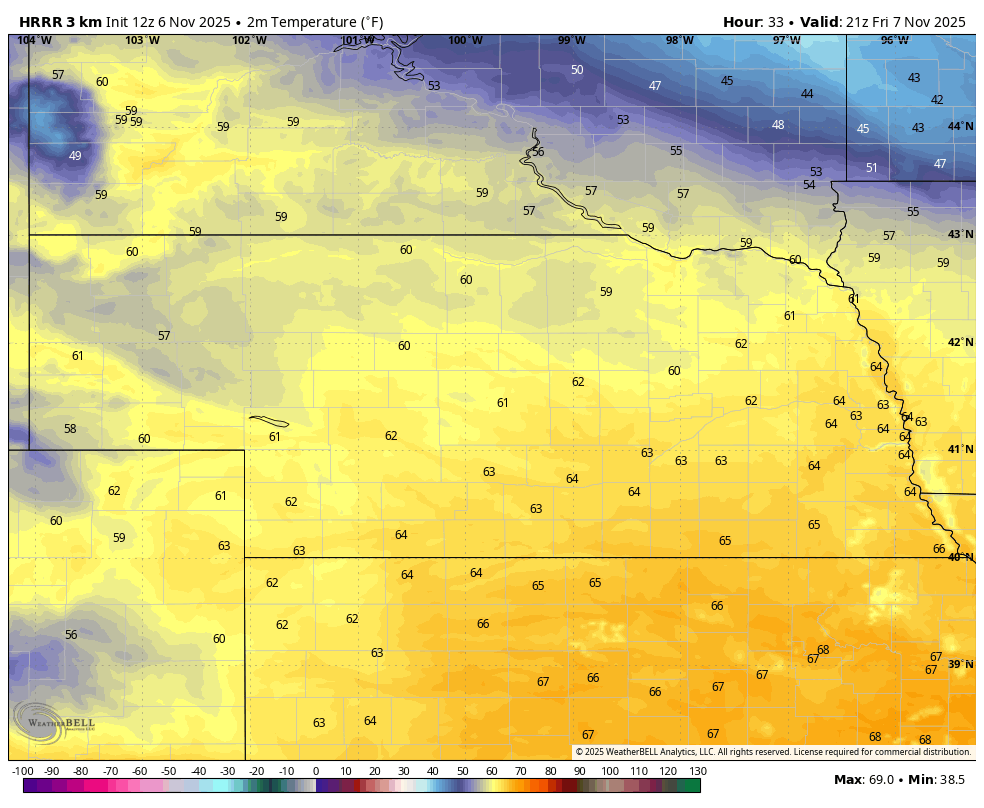
Figure 1. Projected temperatures at 3 CST/2 MST tomorrow
Quick taste of winter
By Saturday morning, a ridge in the western U.S. will start to amplify and a trough is expected to deepen over Hudson Bay and push toward the southeast. That will drag a stronger cold front through the region during the day Saturday, which will bring colder temperatures and breezy winds from the north-northwest. Temperatures likely will top out in the lower 50's across the southern portion of the state with highs in the 40's elsewhere. There will be a chance of showers across northeast Nebraska on Saturday morning but amounts should remain light. The rest of us will just see some cloud cover on Saturday morning with some clearing expected by Saturday afternoon.
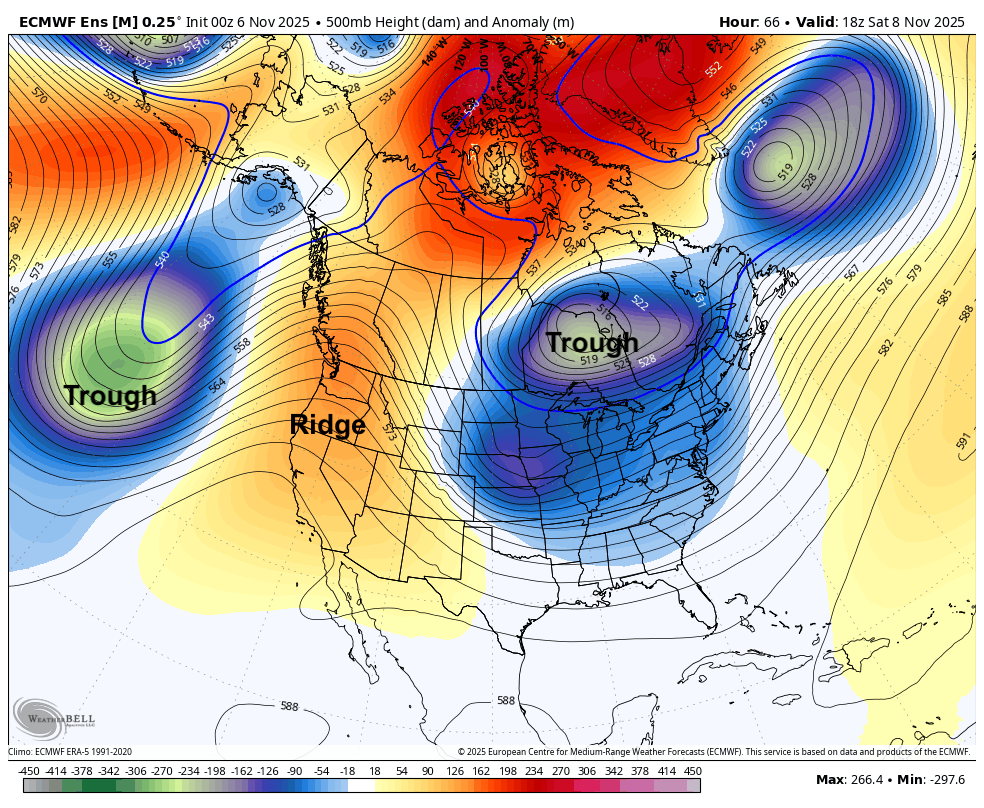
Figure 2. 500-mb heights midday Saturday
The coldest air will come in overnight Saturday into Sunday and temperatures will be kept well below seasonal averages. High temperatures should make it into the 40's in western Nebraska with highs of 35-40°F elsewhere. It's possible the far northeast corner will struggle to get above freezing on Sunday. Coldest temperatures of the autumn season thus far for all but the Panhandle will be with us on Monday morning with lows in the teens for most of the state. At least the sun should be out on Sunday and winds will back off somewhat. That should help take the bite out of the air.
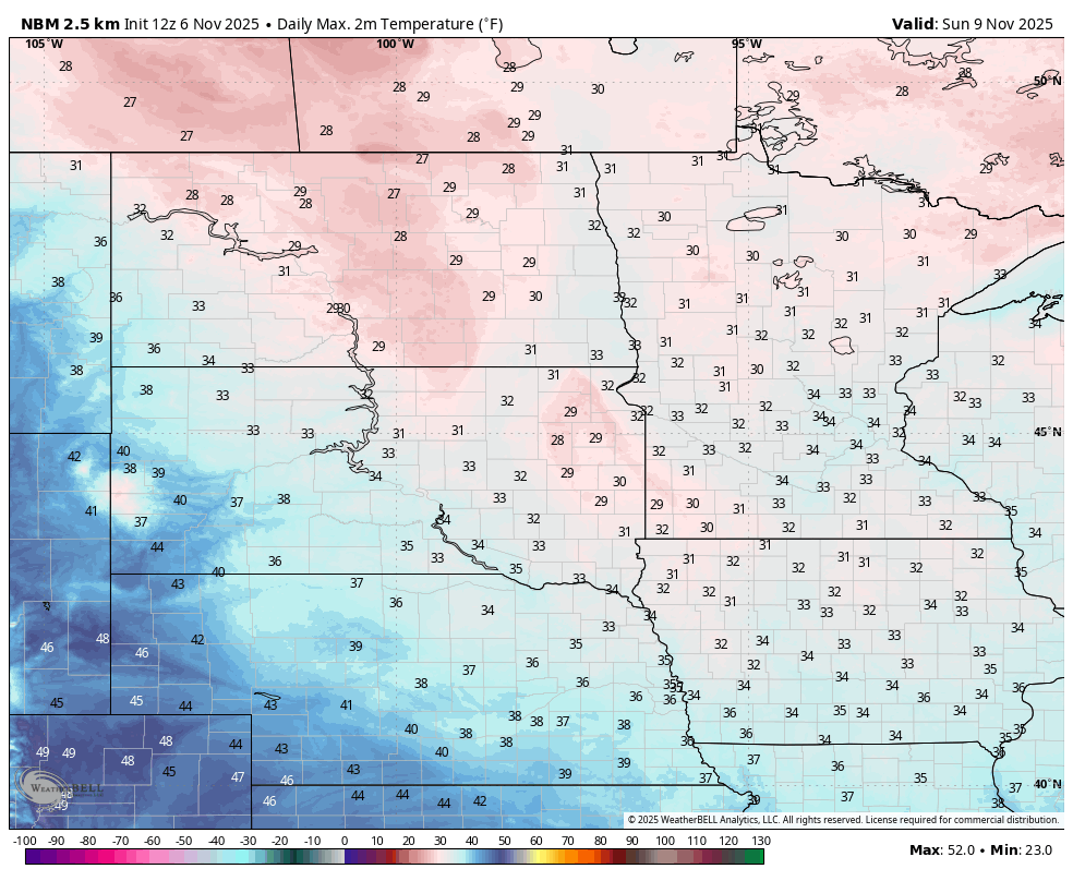
Figure 3. Projected high temperatures on Sunday
Warm-up
As the surface high shifts east during the day on Monday, warmer air will return the western side of the state with highs getting into the 60's (western Panhandle) and upper 40's to 50's in West Central Nebraska. The eastern side of the state will have one more chilly day to contend with highs mostly in the lower to mid 40's. The warmer air will make good eastward progress on Tuesday with highs in the 60's statewide with lower 70's probable in southwest Nebraska. A nice treat for Veterans Day.
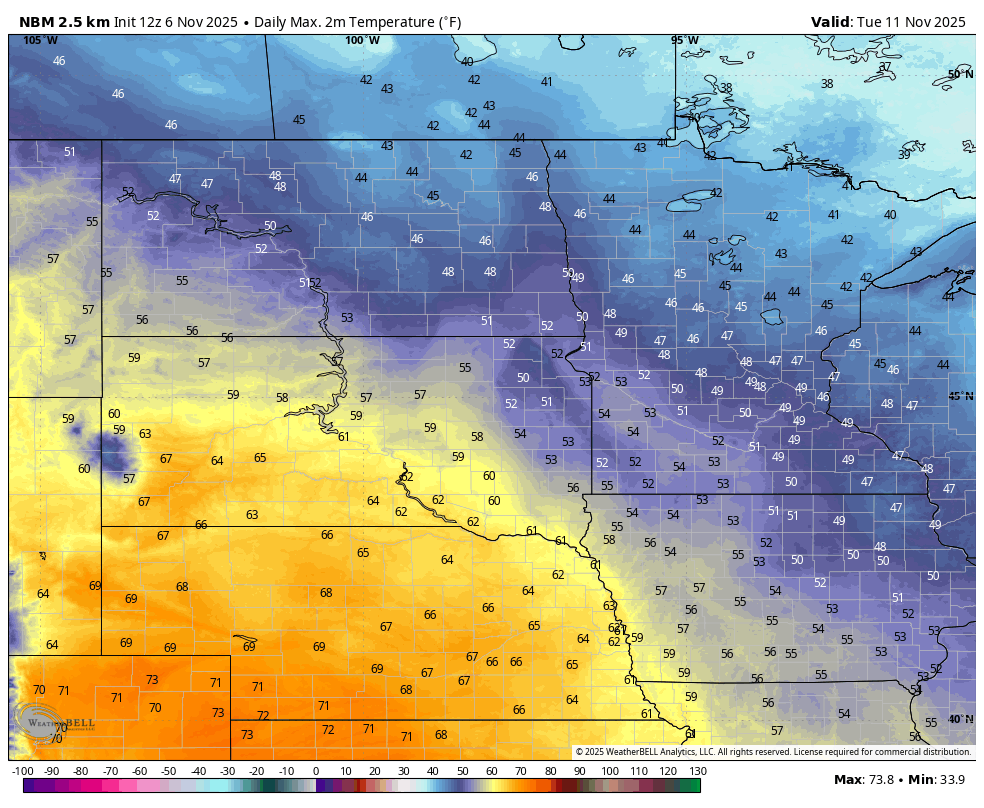
Figure 4. Forecast high temperatures on Tuesday
With ridging in place over the western and central U.S. later in the week, temperatures will be quite mild by mid-November standards with temperatures generally running 10-15°F for the remainder of the week. There are some hints in the ECMWF AI model that late next week may be exceptionally mild in eastern Nebraska as southerly flow increases ahead of western troughing. Regardless expect a lot of days with highs in the 60's next week and low temperatures that are seasonally mild. Wind speeds should be on the lighter side from Monday-Thursday, but may be a bit breezy from the south in the eastern half of the state by Friday.
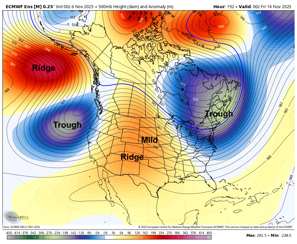
Figure 5. 500-mb height anomalies next Thursday evening
Rain chances
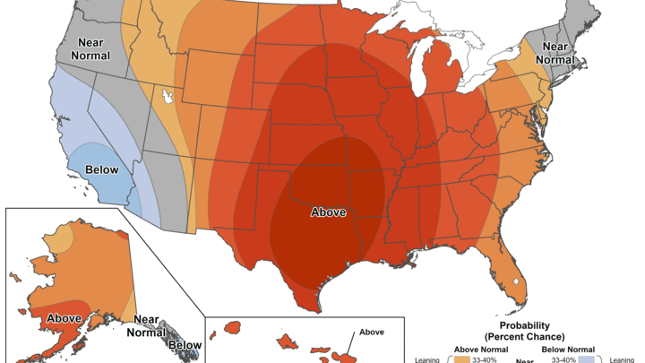
By next weekend troughing in the western U.S. is expected to head toward the Central Plains. This should open up chances for precipitation across the state by later in the weekend. Amounts and timing will depend on where the surface low develops and goes and how quickly it moves. A slower evolution would mean more time to draw up moisture from the Gulf and would increase the chances that more of the state gets a decent shot of moisture. For most of us it likely will be the first measurable precipitation in the month of November. The CPC is more bullish on the 8-14 day period being wetter across the state and most of the country. Additional chances of moisture appear possible around the 20th-21st. Temperatures generally will remain mild through the period.
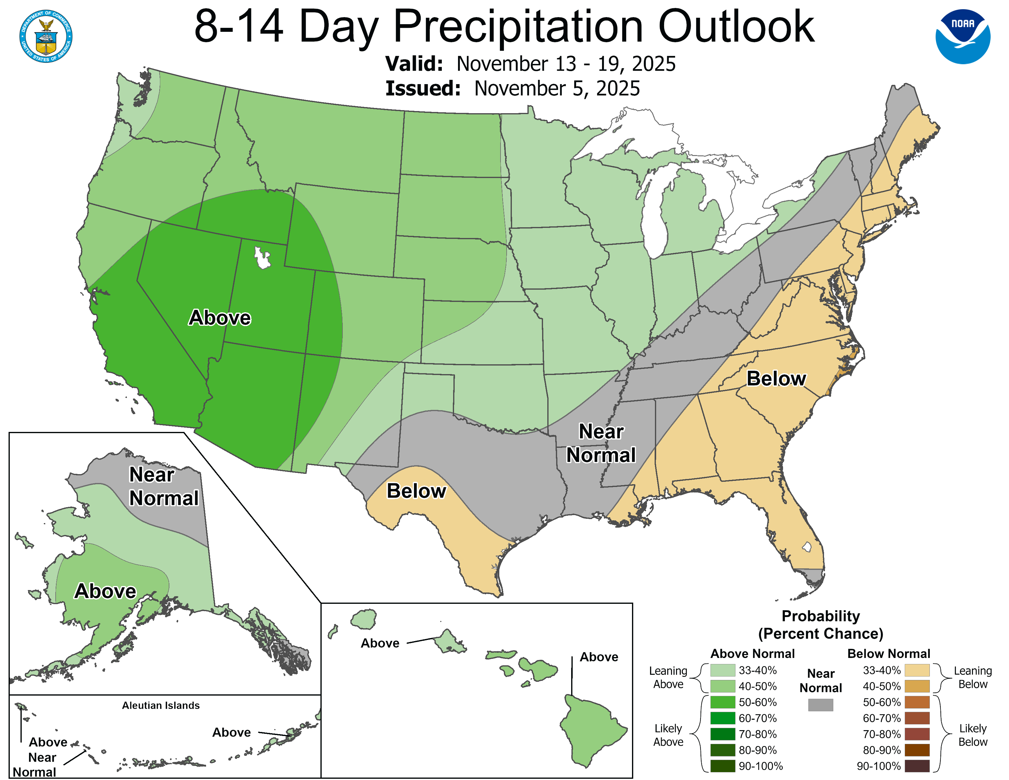
Figure 6. CPC 8-14 day precipitation outlook


