Severe storms and flash flood potential
A shortwave is currently moving into the High Plains region which will help initiate showers and thunderstorms across a good portion of the state starting this afternoon in the southern Panhandle, west central Nebraska and the northern section of the state east of Valentine. Additional development is likely during the evening hours further south and east as the low-level jet kicks in, with the prospects a full blown mesoscale convective system looking fairly good. This should yield some moisture for most everyone in central and eastern Nebraska. But as has been the case most of this summer, the amounts will not be equitable. Some areas, particularly around Highway 20 in northeastern Nebraska, will have flash flooding risk. Higher winds and hail also are possible overnight and cannot rule out a tornado in the early evening hours particularly north of Highway 30 and east of Highway 183. SPC currently has a slight risk out for much of the eastern half of the state today.
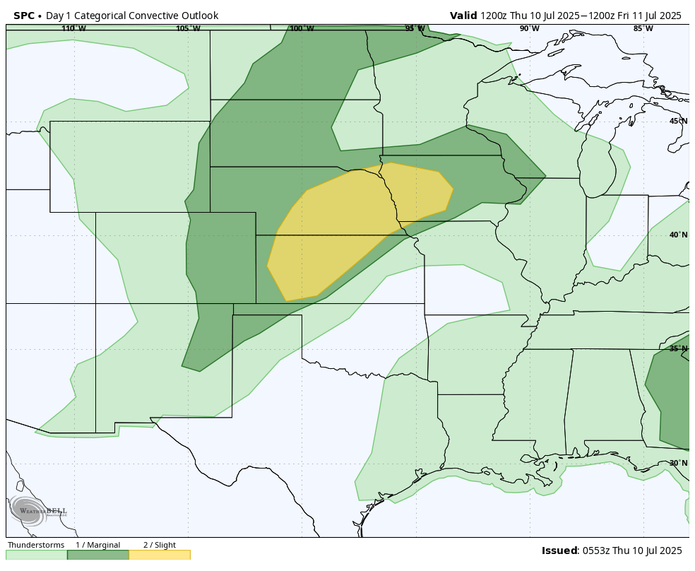
Figure 1. SPC severe storm risk today and tonight
Additional chances of severe weather exist across southeast Nebraska into Illinois tomorrow afternoon with chances for another line of storms moving southeast across the state on Friday night along the cold front. Temperatures tomorrow will be highly dependent on cloud cover and outflow boundaries from storms tonight. Highs in the 80's are likely statewide with temperatures getting over 90°F certainly possible in southern and eastern sections of the state if there is enough clearing. Temperatures will be cooler in the Panhandle. But temperatures getting above 90°F tomorrow would increase the risk of thunderstorms in the afternoon hours. All in all, most of the state outside the northern Panhandle has a shot at getting useful moisture in the next 36-48 hours.
Pleasant Saturday
After the frontal passage we will enjoy a brief break from the warmer temperatures with highs in the lower 80's for most of us on Saturday and temperatures dropping into the upper 50's and low 60's on Sunday morning. Clouds may linger for part of the morning in eastern Nebraska but full sunshine should be the rule by afternoon for everyone. All in all the weather looks very nice for outdoor activities on Saturday and Saturday evening, especially with a gentle breeze expected.
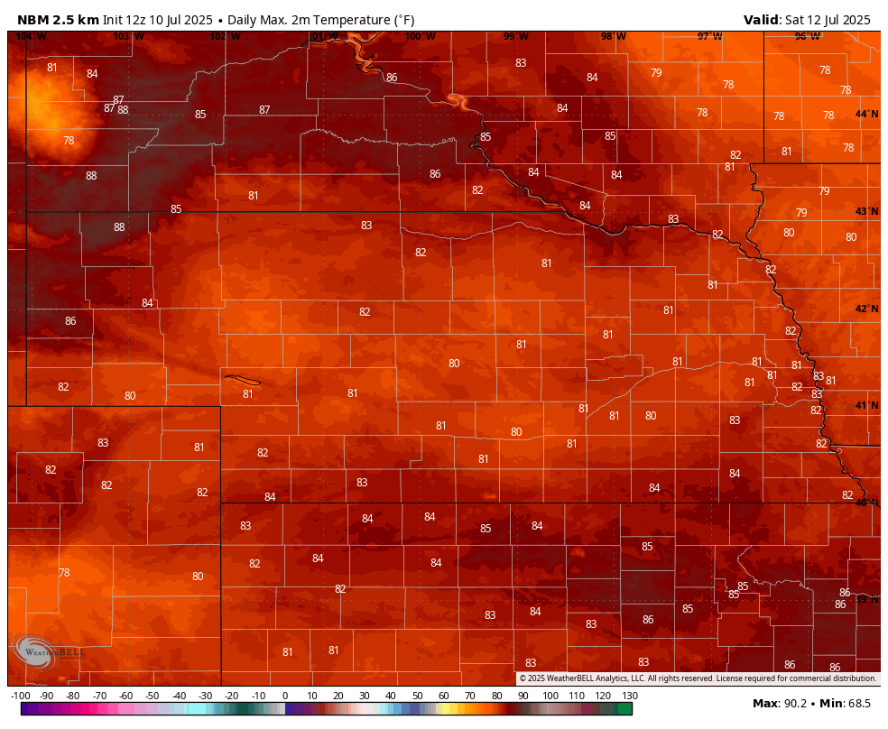
Figure 2. Projected high temperatures on Saturday
Brief return to heat
Ridging will briefly become prominent again across the north central U.S. early next week and by Monday afternoon, there looks to be a very warm nose of air at 850-mb spreading east across the Dakotas and into Nebraska. This will translate to a hot day statewide with air temperatures well into the 90's in western Nebraska, possibly approaching 100°F near Chadron. Central and eastern Nebraska will be southeast of the warmest air at 850-mb (~5200 feet above sea level) and with low-level southerly flow helping to increase dewpoints, temperatures should stay below the mid 90's. But with dewpoints likely getting into the 70's, the heat index may exceed 100°F at times in the eastern portion of the state.
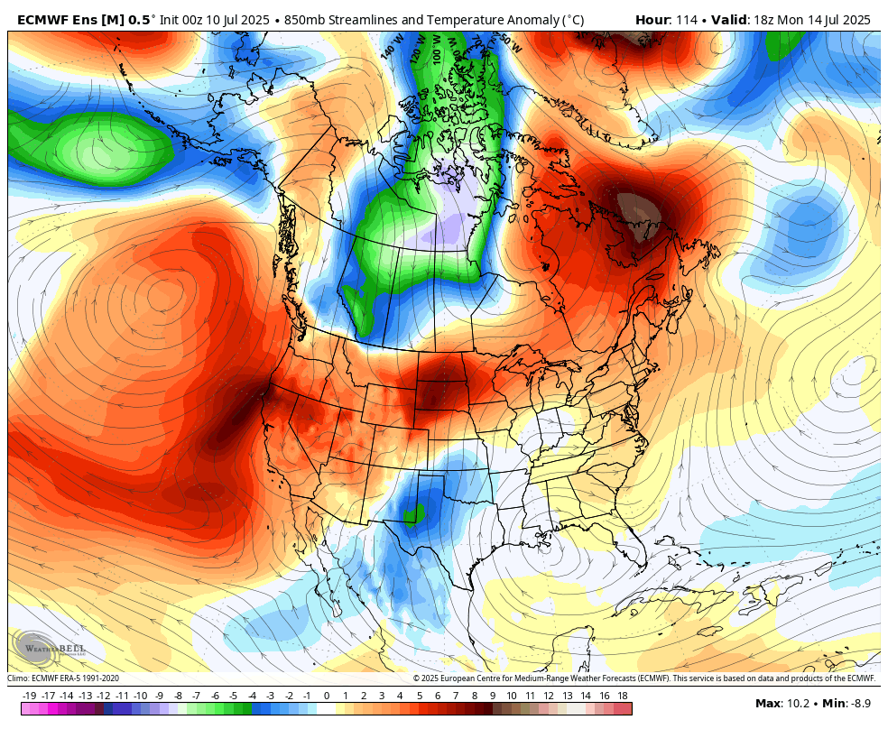
Figure 3. 850-mb temperature anomalies on Monday afternoon
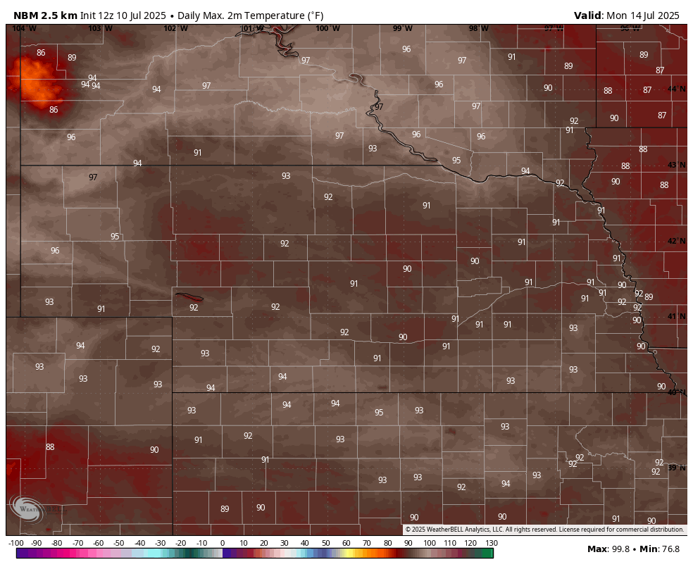
Figure 4. Forecast high temperatures on Monday according to the National Blend of Models
Rain chances and cooler temperatures
By Tuesday afternoon a sharper trough at 500-mb will be coming out of Canada into the north central U.S. and at the surface, a seasonally strong cold front will be moving through the state. This will bring down temperatures quite a bit for the northwestern 1/4 to 1/3 of the state while seasonal temperatures prevail ahead of the front. This also may be a slower moving front as ridging to the east may help hinder its eastward progress for a time. This means that temperatures may remain seasonal through the day Wednesday in the southeast quadrant of the state, while being well below average in the Sand Hills and Panhandle. Weather looks favorable for wheat harvest in western Nebraska through the middle of next week with a possible delay later on Wednesday.

Figure 5. 500-mb height anomalies next Wednesday afternoon
A slower moving front also complicates the precipitation forecast. It's possible that one round of showers and thunderstorms could work through much of the northern part of the state on Tuesday night with another round focused between Highways 30 and 36 on Wednesday afternoon into Wednesday night. Regardless, this could be a favorable scenario for some places to pick up over 2 inches of rain during the middle portion of next week. Recommend checking back on Monday as details should be more clear by then.
Temperatures should be seasonally cool statewide by Thursday with highs likely not getting out of the 70's for most. Low temperatures should easily dip into the 50's across the northern half of the state on Thursday morning and may drop that cool everywhere if the front is a little more expedient. Temperatures look to remain pleasant between 80-84°F on Friday in eastern and central sections of the state, while a return to the upper 80's looks likely in the Panhandle. Saturday will feature more seasonal temperatures across the state with highs from the mid 80's to lower 90's likely.
Favorable pollination period
A look a little deeper into the crystal ball via the ECMWF AI model shows a chance for another shot of moisture and cooler temperatures coming around July 21st. The CPC shows no real signal on precipitation but favors cooler than average across the main corn/soybean producing region of the U.S. in the 8-14 day outlook. If the pattern remains active like this for the next few weeks, it is probable that most of the prime corn/soy area in Nebraska, the 'I' states, and Minnesota will be going through the pollination period of corn and early soybean pod setting stages with favorable weather. The periodic shots of cooler air with occasional drops in humidity with northerly surface flow may be beneficial for limiting some disease spread.
Crop condition ratings for corn and soybean came in strong for Nebraska in the latest Crop Progress Report and generally very good (see related links) across the Corn Belt with only pockets of northern Illinois experiencing drought issues. If central and northern Illinois gets the rain it needs in the next week, which is probable, then we may be setting ourselves on a path toward a record corn and soybean crop. Long way to go and August could still bring trouble. But at this point, barring a catastrophically bad August, I see no reason to think that there are going to be significant declines in total crop production compared to last year.


