Fire danger will be high today across central sections of Nebraska where Red Flag Warnings are currently in place. It will be elevated elsewhere in the state. Reason for the danger is the combination of windy conditions combined with low relative humidity levels this afternoon. Winds should be a bit lighter tomorrow afternoon and should be low enough on Wednesday and Thursday to keep fire danger levels down. It will certainly be mild the next several days with most of the state spending time in the 50's each afternoon through Thursday. With a lack of snow cover and downsloping westerly winds, I suspect we will see temperatures approach 60 tomorrow in places Holdrege, Hastings, Grand Island, and Crete.
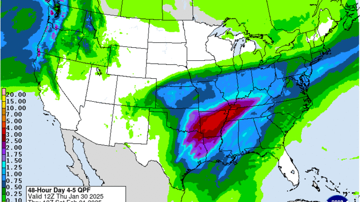
By late Thursday afternoon the upper level low that is currently bringing heavy rain to California will be moving into the Central Plains. This will bring a good chance of rain to the southern half of the state, with the possibility of getting closer to an inch of rain in southeast Nebraska. Moisture return looks adequate and the speed of the storm is such that a modestly long duration of rain can be expected. If this storm was able to tap into colder air, we would be looking at the possibility of significant snow along the I-80 corridor and points south (east of Lexington). But given that this system is cut off from the polar jet, the air mass will be sufficiently warm for all or mostly rain. Depending on the dynamics of the system, it is possible that there could be a period of snow between Omaha and York on Friday morning but right now, all rain is the expectation.


