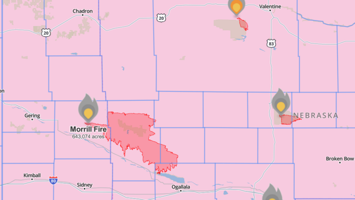
Over a decade after its last record-breaking fire, Nebraska finds itself battling four simultaneous fires. On March 12th, the Morrill Fire was first reported and quickly grew into the Cornhusker State's largest wildland fire ever. The ensuing blaze has seen the state order evacuations from multiple towns and put seven counties into a state of emergency. Agencies and volunteer departments across the state came together under the guidance of the Rocky Mountain Complex Incident Management Team. Now, a week later, the Morrill Fire is almost completely contained and its smaller companions are also 60-80% contained. While the official investigation into the exact cause is ongoing, what weather conditions put Nebraska at risk last Thursday?
The Red Flag Warning
On March 12th, 2026, the National Weather Service issued Red Flag Warnings for the entire state of Nebraska. While this is a warning Nebraskans are becoming more used to seeing, what does it mean? A Red Flag means your area is at high risk for both quick fire ignition and high fire intensity. This means authorities are not just worried about fire starts, but how much damage those fires will be able to do in the short time it takes firefighters to respond. In most counties, this means any burn permits previously issued are temporarily suspended. Though, even if your permit isn't suspended, it is recommended you still avoid burning. Additionally, the Nebraska Game and Parks Commission may close trails or entire areas during these times for public safety. Any gatherings or events involving fireworks or pyrotechnics are likely cancelled during this time. Even if you have a fire extinguisher handy and are confident with it, don't risk an open flame! Red Flag Warnings are specifically calibrated for weather that can overtake you and grow any small spark into a burgeoning blaze.
The 30-30-30 Rule
First, some background to better understand what parts of weather we study for wildfire: The international shorthand for fire weather is to look out for the "30-30-30". This measures three weather variables: relative humidity, temperature, and windspeed. The first sign is when your relative humidity is below 30%. This is an incredibly dry atmosphere-- not something we always have here in Nebraska! Imagine a field of prairie grass, like what covers most of our state. With this low air moisture, the more water will evaporate from our grasses to fulfill atmospheric demand. This begins to dry out the grass field.
The second sign is when the air temperature is over 30°C (or roughly 85°F for us Americans). Going back to our prairie grass, they dry faster as hot air increases the atmosphere's capacity for water. The high heat and low air moisture makes for easy ignition conditions. A spark struck by a poorly-secured trailer or an errant cigarette will take advantage of these dried fuels within a second. But what of the third 30?
The third sign is when your wind speed is over 30 kilometers per hour (or about 18 miles per hour). High wind speeds "push" fire into erratic behaviors when they would otherwise remain relatively stationary. In our hypothetical prairie, a fire start in one corner might only slowly creep through the brush under slow winds. But with high wind gusts, the flames are moved into other patches of hot and dry grass. It isn't just visible flame that is a problem, either. The wind provides a convective current over the fire. This moves heat to potential fuels and pre-heats them. By the time actual flames touch this pre-heated grass, its internal temperature is high enough that fire spreads to it rapidly.
Think of the last gusty day you experienced, with how random and fierce the wind was. Now, think of how that would move fire through a hot and dry field. The unpredictability and strength makes an already urgent situation chaotic for first responders. With even just two out of the three criteria met, wildfires can threaten nature and Nebraskans alike.
Morrill's "30-30-30" on March 12
So, how did the Morrill Fire compare with the 30-30-30 rule? The Nebraska Mesonet archives* show that at the time the fire was reported, Morrill county was experiencing a relative humidity of 19.6% and a temperature of 67°F. While that's not the hottest environment, that's pretty dry air for the grasslands to be under. When we check our last part of this trio, however, we see why things got so intense so quickly. The surface winds at time of ignition were averaging 34 miles per hour.
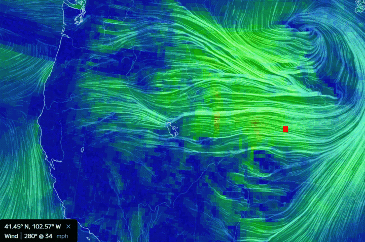
So, we can see that Morrill met two out of the three conditions. While we still don't know the exact ignition cause, we know now just how serious the 12th's Red Flag Warning was. You don't need extreme heat for extreme fires to still happen. Referencing back to Figure 1, we can see just how far these winds spread these fires. Morrill Fire especially shows just how dramatically high winds influence fire behavior.
Looking Forward
One of the Student Intern projects for the Nebraska State Climate Office this year has been to analyze Nebraska's future wildfire vulnerability. This is being done using statistically-downscaled climate modelling to simulate the next century's worth of weather. When finished, the office will be able to provide a better understanding of which areas of the state are more vulnerable, when, and to which specific weather variables. More will be published on this project by the end of the academic year.
*Nebraska Mesonet station Broadwater 7N


