Heat
The biggest story the next few days will be the heat. An upper-level ridge is building eastward and will be centered near the Great Lakes by Saturday night. The warmest air in the lower levels (e.g., around 850-mb) will be on the western side of the ridge this weekend and with decent mixing expected, temperatures will be well above average statewide the next few days. Record temperatures will be possible tomorrow in McCook and Omaha could flirt with breaking a record high on Sunday. In general maximum temperatures the next few days will fall short of the peak heat experienced during this period of June in 1988.
Temperatures at first pitch for the CWS Finals games this weekend likely will be in the upper 90's to around 100°F with a heat index between 105-110°F both Saturday and Sunday. A stronger breeze from the south may help a little, but the most extreme threshold for heat danger using the Wet Bulb Global Temperature (WBGT) and Cattle Comfort Index (CCI) likely will be reached in the afternoon hours the next few days and possibly on Sunday. Both also take solar radiation and wind speed into account to get a more accurate assessment of heat risk to humans and livestock.
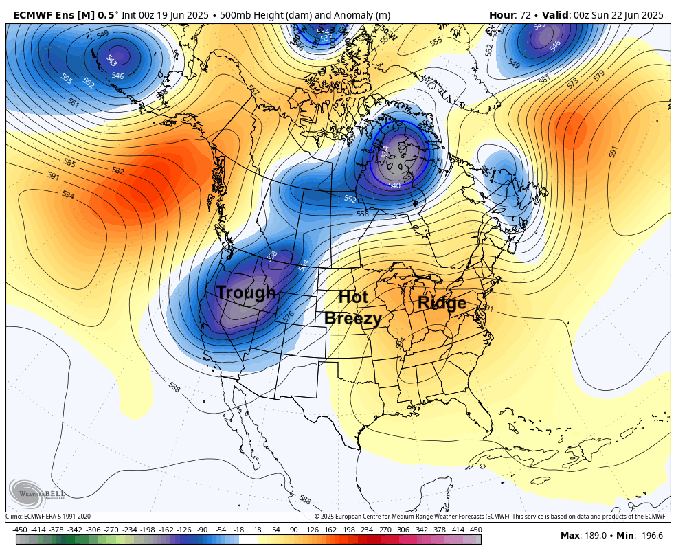
Figure 1. 500-mb height anomalies this weekend.
Reasonable chance almost everyone hits 100°F tomorrow and/or Saturday. Exception may be the highest elevations in the Panhandle and the lowest elevations in the far southeast corner where humidity will be highest. Warmest temperatures likely will be from McCook to Harlan County where 105-107°F will be possible and around Valentine where temperatures are likely to be over 104°F the next few days. Dewpoints will be over 60°F in central and are likely to be over 70°F at times in eastern NE the next few days, which will make the apparent temperatures higher. With a pressure gradient setting up between high pressure to our southeast and low pressure to our west, wind speeds will be higher this weekend. Between the breeze and dewpoints likely remaining below the mid 70's, we aren't looking at a repeat of mid-August 2023. But this will easily be the hottest weather so far this year and caution is advised for outdoor activities. In addition, overnight temperatures may well not drop below 80°F in the most urban areas of Omaha and Lincoln this weekend.
Biggest uncertainty will be the chance that maximum air temperatures either overachieve due to better than expected mixing or underachieve a bit due to increased low-level moisture coming up from the abnormally wet southern Plains. There will also be slight chances for storms to develop in the afternoons if convective temperatures are achieved. In addition, there is a slight chance for storms overnight tonight in central and eastern NE. Those likely would be well out of here by tomorrow morning. But any lingering cloud cover in the morning may knock down temperatures a little.
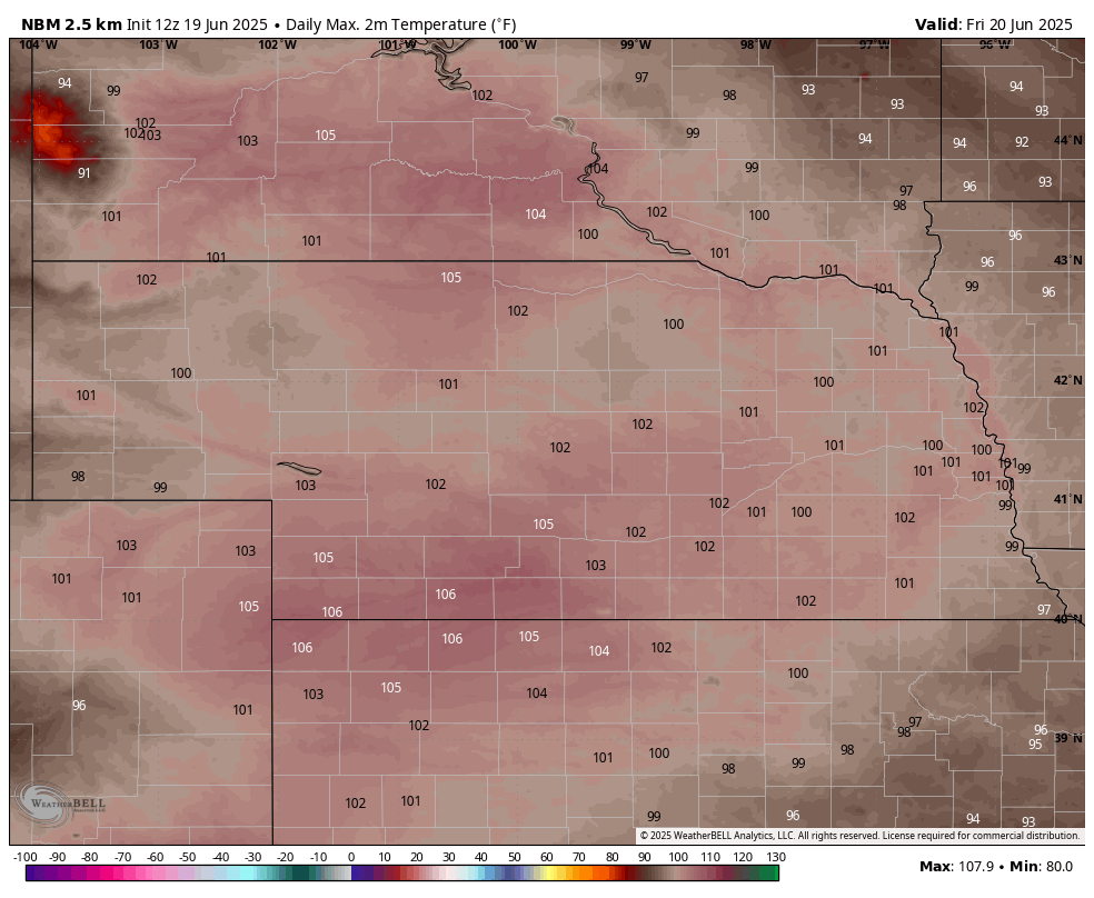
Figure 2. Forecast high temperatures tomorrow
Tricky temperature forecast Monday
A cold front will begin moving through the state on Saturday night and should clear the Panhandle during the day on Sunday and should be along a line from North Platte to O'Neill by Sunday evening. Out ahead of it, temperatures will be in the upper 90's to around 100°F. Behind it temperatures will be in the mid 80's. Thunderstorms will be likely in western and north central sections of the state on Sunday evening with over a half inch possible. The front will continue to make progress during the day on Monday but exactly how far it makes it and when/where it stops is still a little uncertain.
Getting through Kearney and Norfolk by midday is very likely and it should clear Grand Island and Columbus by early afternoon. There is a chance it could even clear the Lincoln and Omaha metro areas before midday and a good chance it does by evening. Ahead of the front it will be another sultry day and immediately behind it will be seasonal. Thus, parts of eastern NE could see highs only get into the lower to mid 80's and it may be in the mid 90's. Temperatures will be very pleasant in western and north central sections of the state with highs in the lower 70's.
Heavy rain
By Monday night the ridge in the east will be well-entrenched and this will act as a strong barrier to the southeastward progression of the cold front. It is possible it could clear the state entirely by Monday night but it is possible it may stall in a line roughly from western Kansas into southern Wisconsin, which means it may be effectively stationary for a prolonged period of time between Lincoln and Falls City to St. Joseph, MO early next week.
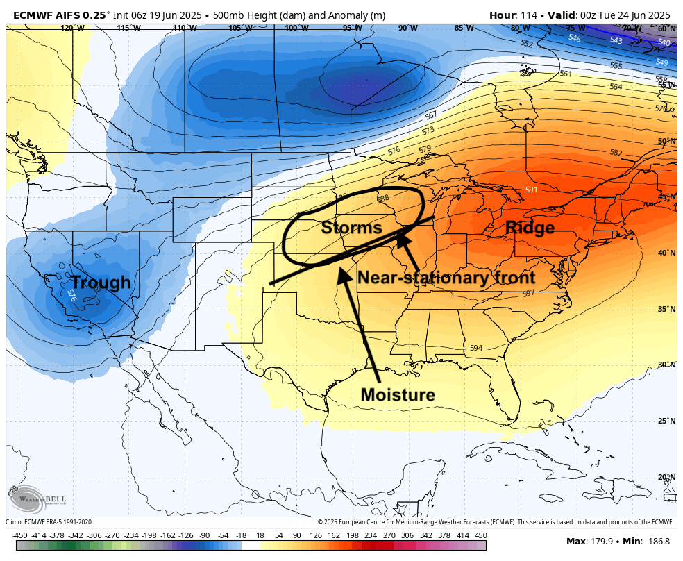
Figure 3. 500-mb height anomalies next Monday evening
This near-stationary boundary (as shown in Figure 3) will be the focal point for multiple rounds of showers and storms starting Monday night through early Thursday, possibly even beyond that, for central and eastern sections of the state. This setup of a stout eastern ridge, western trough, and near-stationary front over our region is a very good recipe for heavy rainfall. That some places will get excessive amounts of rain between Monday afternoon and Thursday evening is not the question. The biggest question will be where.
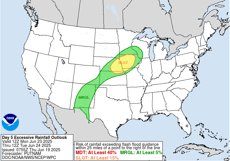
Figure 4. WPC excessive rainfall outlook
Monday night could be quite wet for much of south central and eastern Nebraska and severe weather may be possible too. The WPC does have much of the eastern half of NE and western IA in the slight risk category for excessive rainfall. Where storms develop in subsequent days will be highly contingent on where the boundary is sitting, which will be influenced by the broader upper level flow and convective out flow. It seems possible it could get as far south as the northern end of the KC metro area on Monday night before retreating north during the day on Tuesday and then retreating back to the southeast on Wednesday night. This may focus the heaviest rainfall north of Highway 30 on Tuesday and south of it on Wednesday night into Thursday.
Regardless, areas between Highway 136 and Highway 20 in central eastern sections of the state have a chance at getting several inches of rain next week. I feel reasonably confident some places will get over 6" of rain in the eastern third of NE but I have little confidence in where that may be. How warm temperatures get in the afternoons and where storms/excessive rainfall potential will be hinges on this boundary exists.
Temperatures should remain on the cool side through mid-week in western NE with a return to more seasonal temperatures by later in the week. There also will be chances of moisture between Tuesday night and Thursday morning, especially in the eastern Panhandle and Sand Hills. But the heavier rain should remain east of Highway 83. Temperatures will be seasonal to seasonally warm later in the week statewide with some chance of showers and storms in the northern section of the state. The CPC shows warmer and wetter than average favored to close out the month.
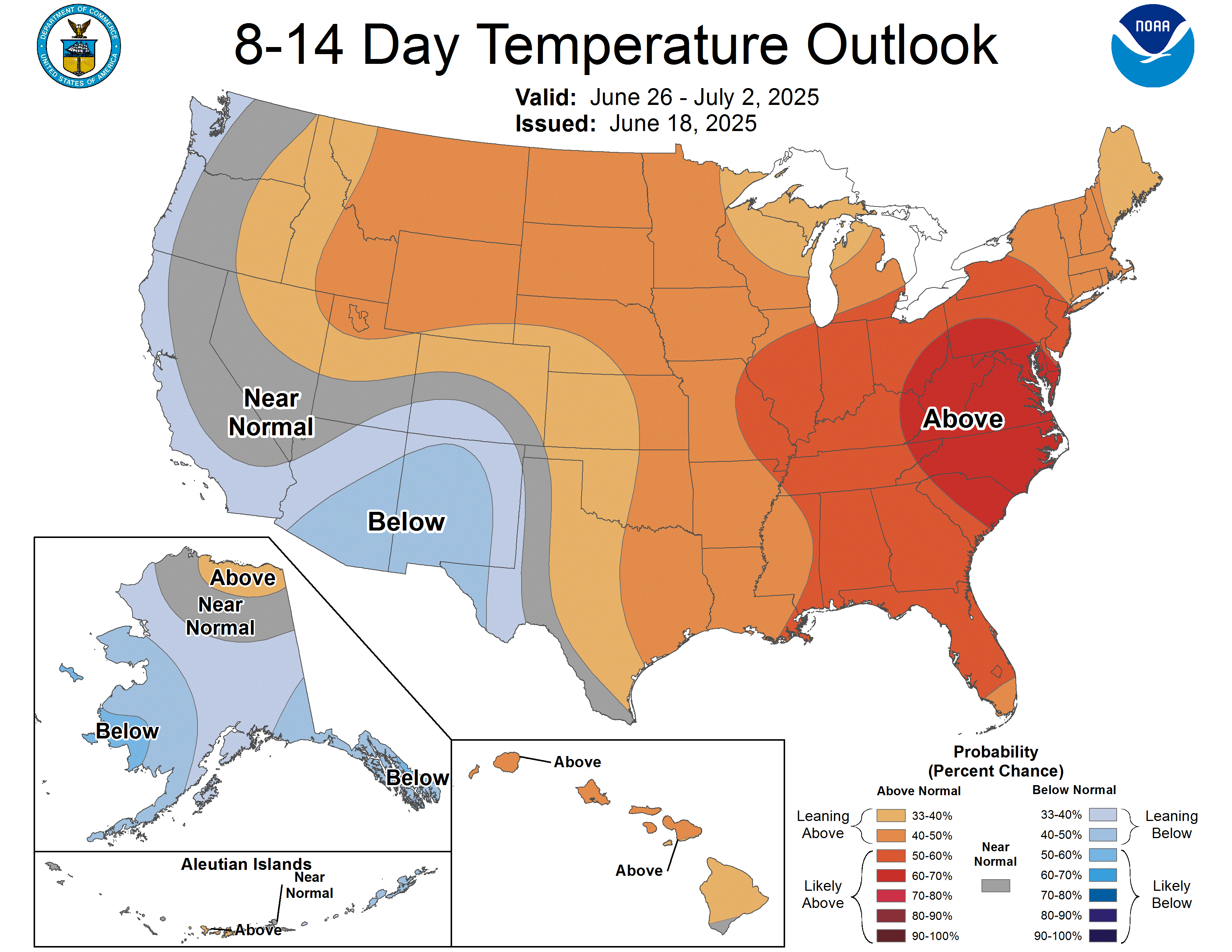
Figure 5. CPC's 8-14 day temperature outlook
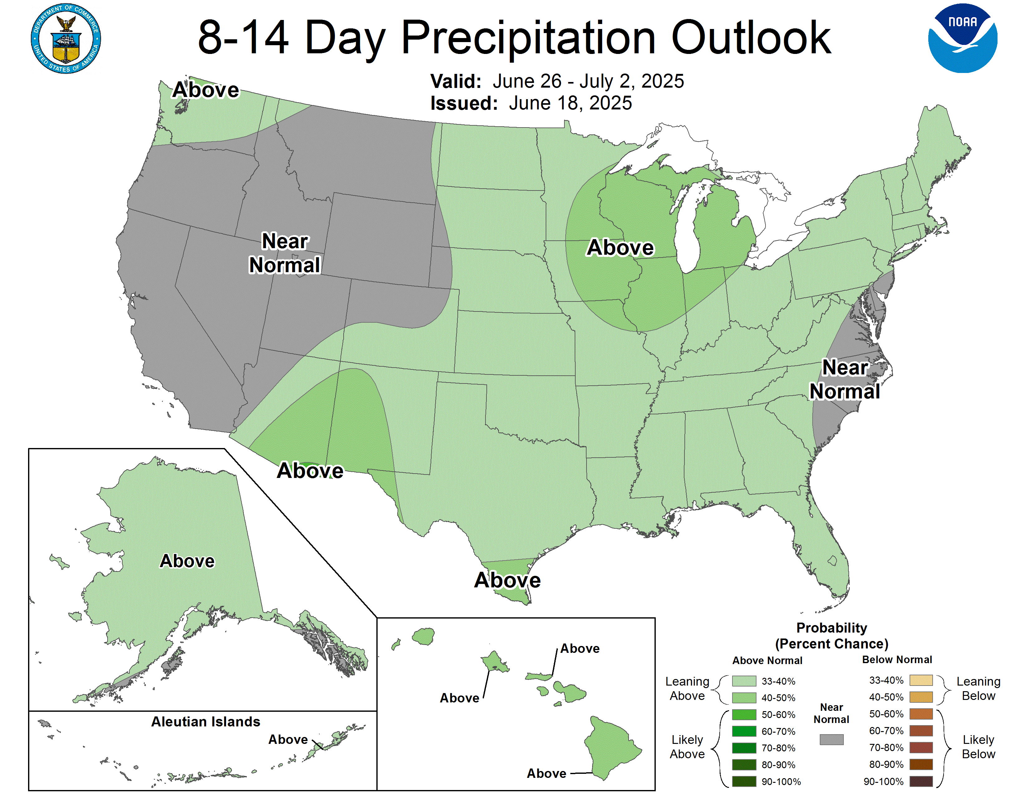
Figure 6. CPC's 8-14 day precipitation outlook


