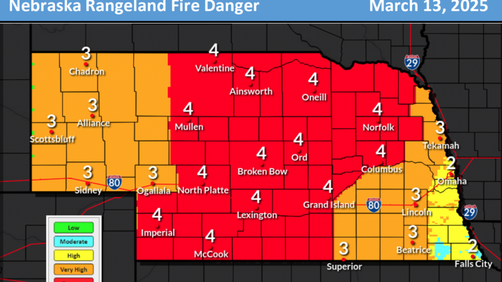
High Fire Danger Thursday
After a relatively calm day today, a tightening pressure gradient will lead to strengthening wind speeds across much of western, central and northeastern Nebraska tomorrow afternoon. When combined with near-record high temperatures, lower humidity, and mostly dormant vegetation, the setup is favorable for high fire danger. Expect red flag warnings to be issued tomorrow for all but southeastern Nebraska and the western half of the Panhandle. Fire danger levels will be highest in the central Sand Hills.
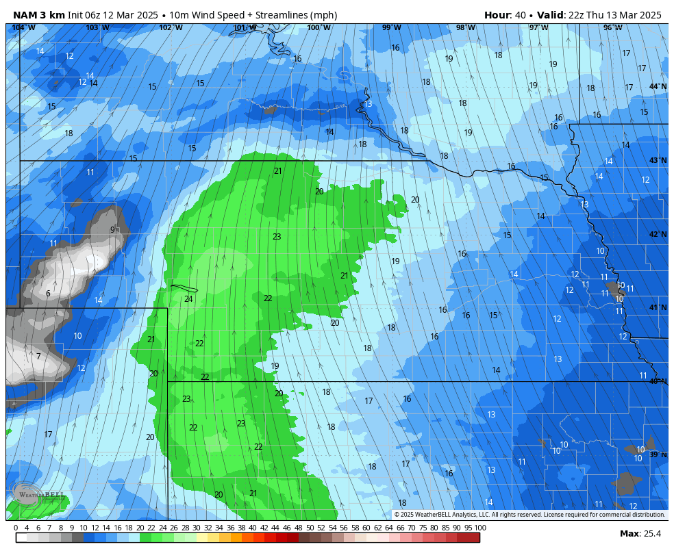
Figure 1. Sustained wind speeds tomorrow afternoon
Bomb cyclone
A storm moving from the Front Range into the Central will strengthen rapidly due to optimal amounts of upper air divergence that comes with the left exit region of a powerful jet stream. Impacts from the storm will be mostly in the form of higher wind speeds but at levels below last Tuesday and Wednesday. Precipitation will be likely for everyone but only northeastern Nebraska is likely to receive a half inch or more. Most areas of the state are likely going to be under a quarter inch unless showers and thunderstorms are more numerous and intense than is currently forecast.
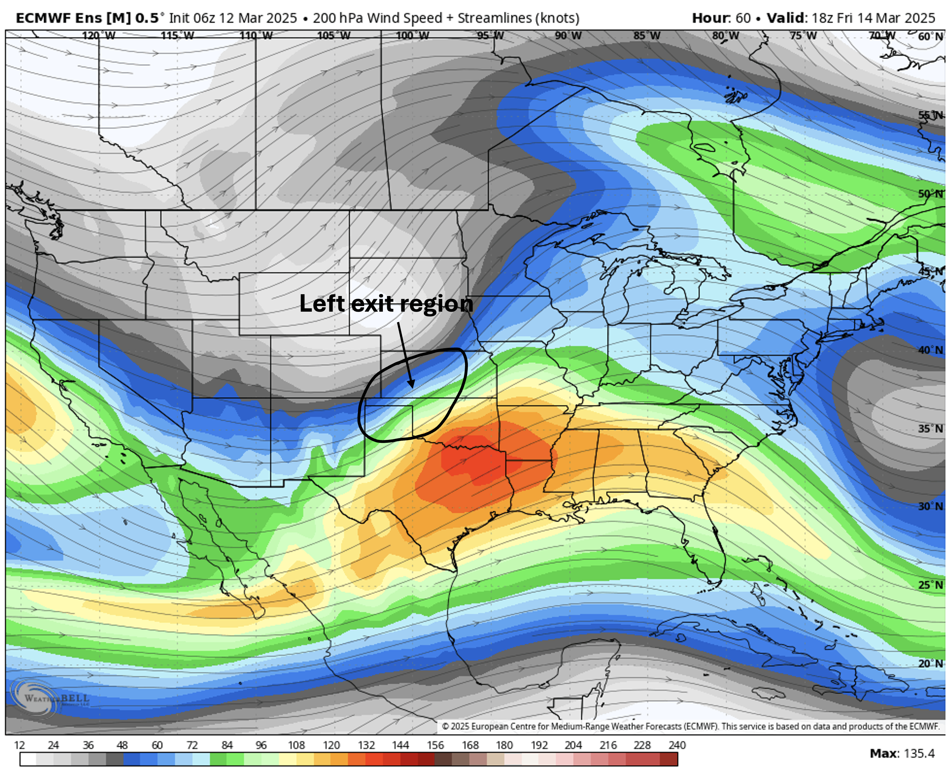
Figure 2. Highlighted area of maximum upper air divergence on the 200-mb wind speed map.
The storm will begin to affect the state starting Friday morning as showers begin to develop across the Panhandle. Rain likely will change to snow later in the day across western Nebraska and winds will be gusty from the northwest. Further east temperatures will be warmer, likely getting into the 70's in eastern Nebraska and into the 60's across the central section of the state. It also will be breezy and showers and a few thunderstorms are likely east of Kearney during the afternoon hours. Severe thunderstorms may be possible in far eastern Nebraska, though the best chance of those are further east. Enhanced risk of severe storms from western Illinois down to Mississippi.
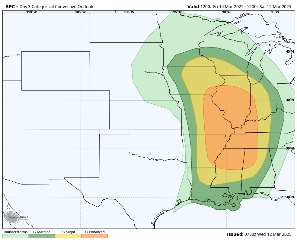
Figure 3. SPC outlook for severe thunderstorms on Friday and Friday night
By Friday night the surface low will be to our east in Iowa and a deformation band of precipitation should set up in the eastern third of the state (excluding the Kansas border counties). This will be more rain than snow but residents in Knox and Holt counties may get a period of heavy snow. Wind speeds will be in the 20-30 mph statewide on Friday night and on Saturday with gusts possibly approaching 45-50 mph in north central and northeastern Nebraska. Not as bad as last week but enough to cause visibility issues in areas where snow does fall. The speed of the storm and the large dry slot near the surface low will prevent anyone from picking up a two inch soaking.
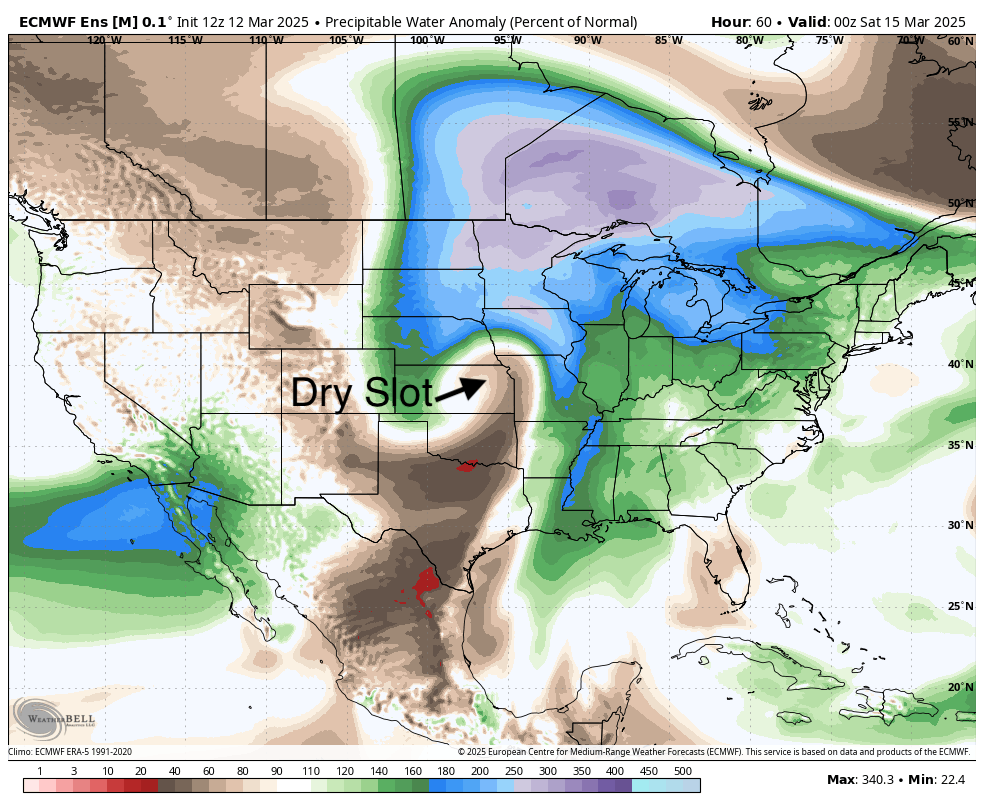
Figure 4. Demonstration of the dry slot in the storm via precipitable water anomalies on Friday evening.
Nevertheless most areas should pick up some moisture on Friday and early Saturday, with amounts over a half inch most likely in northeast Nebraska where the deformation precipitation is likely to be heaviest and of longest duration. Most of western Nebraska should pick up some moisture, including some in the form of snow, but amounts are likely to be under a quarter inch.
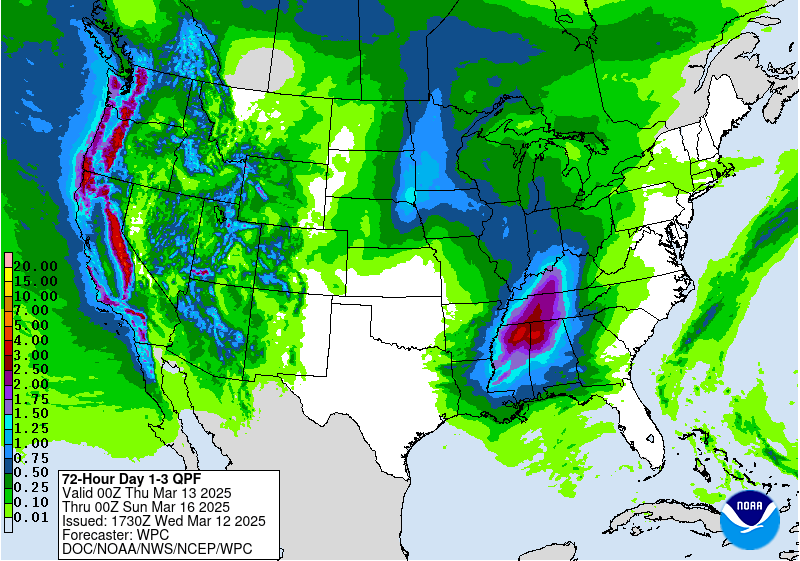
Figure 5. Projected precipitation from the WPC
The central and northeastern sections will have a chance to pick up some showers on Friday morning with more rain likely to fall on Friday night on the back side of the storm. Areas from Ord to O'Neill likely to get a half inch of rain or more with an inch of moisture possible between Wayne and Ponca. Snow will be likely along and north of Highway 20. Best chance of getting 3 inches of snow would be around Niobrara.
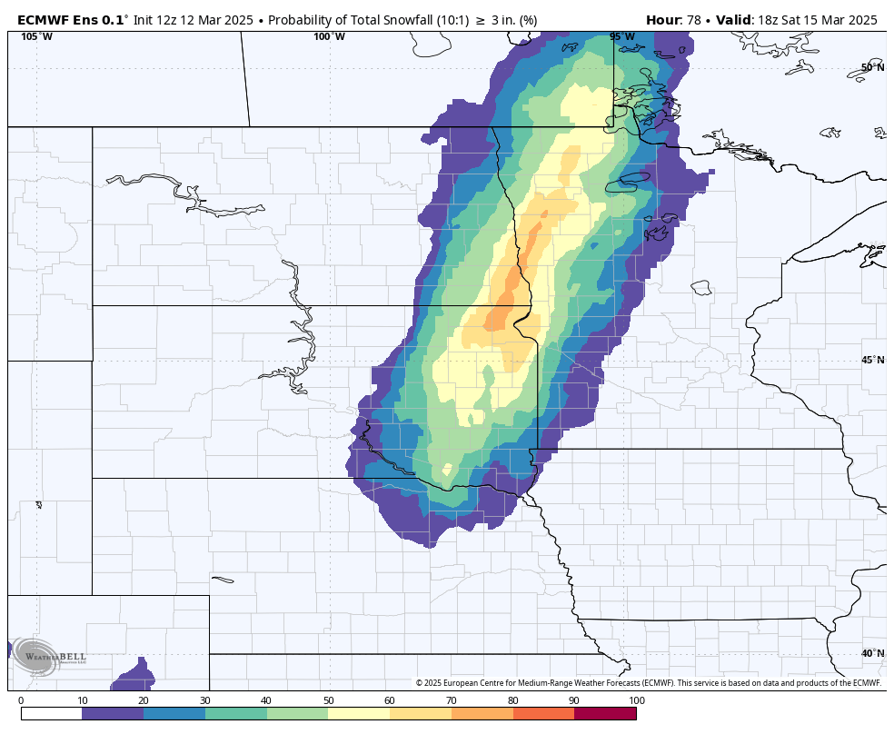
Figure 6. Probability of getting 3" of snow on Friday night and Saturday morning.
The southeastern quadrant of the state is a bit trickier. Some spots could pick up a quarter to half inch early Friday afternoon from thunderstorms and precipitation on Friday night could extend as far south as Lincoln and Nebraska City. But the dry slot is likely to preclude most of southeast Nebraska from getting precipitation on Friday evening and the precipitation on the back side of the low likely won't make it south of Highway 2. So there is a possibility places from Fairbury to Falls City could get nothing but wind from this storm. Fire danger may also be elevated near the Kansas border in southeast Nebraska on Friday evening once the dry slot moves in.


