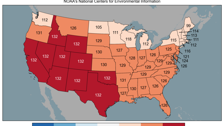
Humid summer so far
It has been a wet and warmer than average summer for most of Nebraska and it has been an abnormally humid summer for pretty much everyone east of the Rockies according to a recent Washington Post article. When we speak of humidity in the summer time, it is better to talk about the dew point: the temperature at which condensation/droplets would start to form. Wet-bulb temperature is probably the best method for determining how oppressive the humidity is but that is a story for another day. The dew point scale with emojis (Figure 1) from the Tampa area NWS office is a good reference.
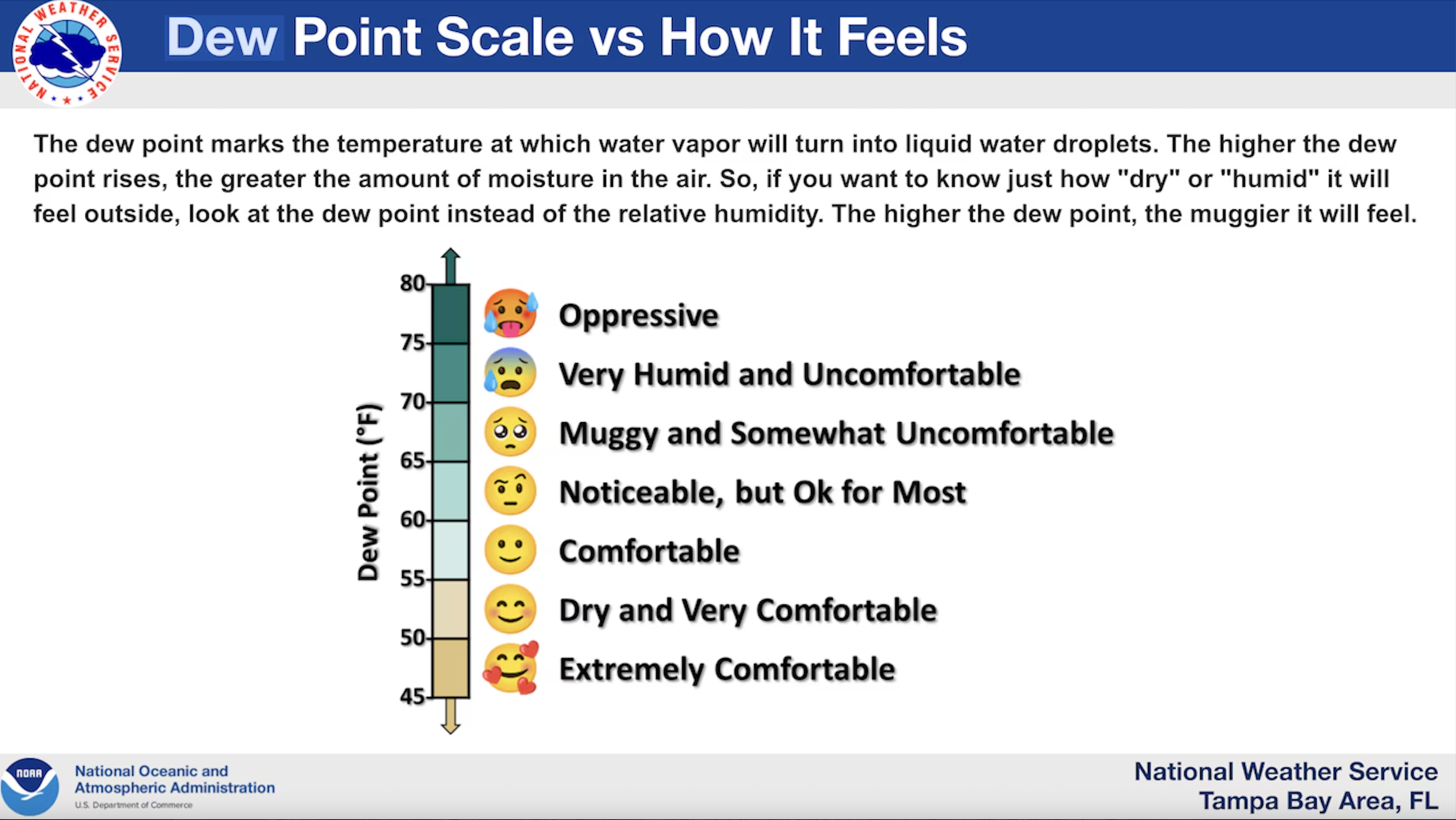
Figure 1. Dew point reference scale compliments of the Tampa Bay Area NWS
A quick look at average daily dew points from long-term stations in Nebraska shows this is also the case here. Since the first of June (period June 1- August 14) the average dew points are top 5 in Omaha, Lincoln, Grand Island, North Platte, and Valentine. Only Scottsbluff has had average daily dew points that are around average and only the summer of 2010 was consistently more humid than this summer at most sites in the eastern half of the state.
July is typically the month when dew points peak in most of Nebraska, though August can best July in some years. This year did not bring record average dew points to any long-term stations but they were generally well above average. PRISM analysis suggests average dew points last month ranged from the low 70's in far southeast Nebraska to the upper 40's in the far southwest Panhandle (Figure 2). Most of the state had average dew points in the mid 60's, with dew points falling into the low 60's and 50's in western Nebraska. This gradient is normal, albeit it is a bit sharper than some years, especially between Bushnell and North Platte.
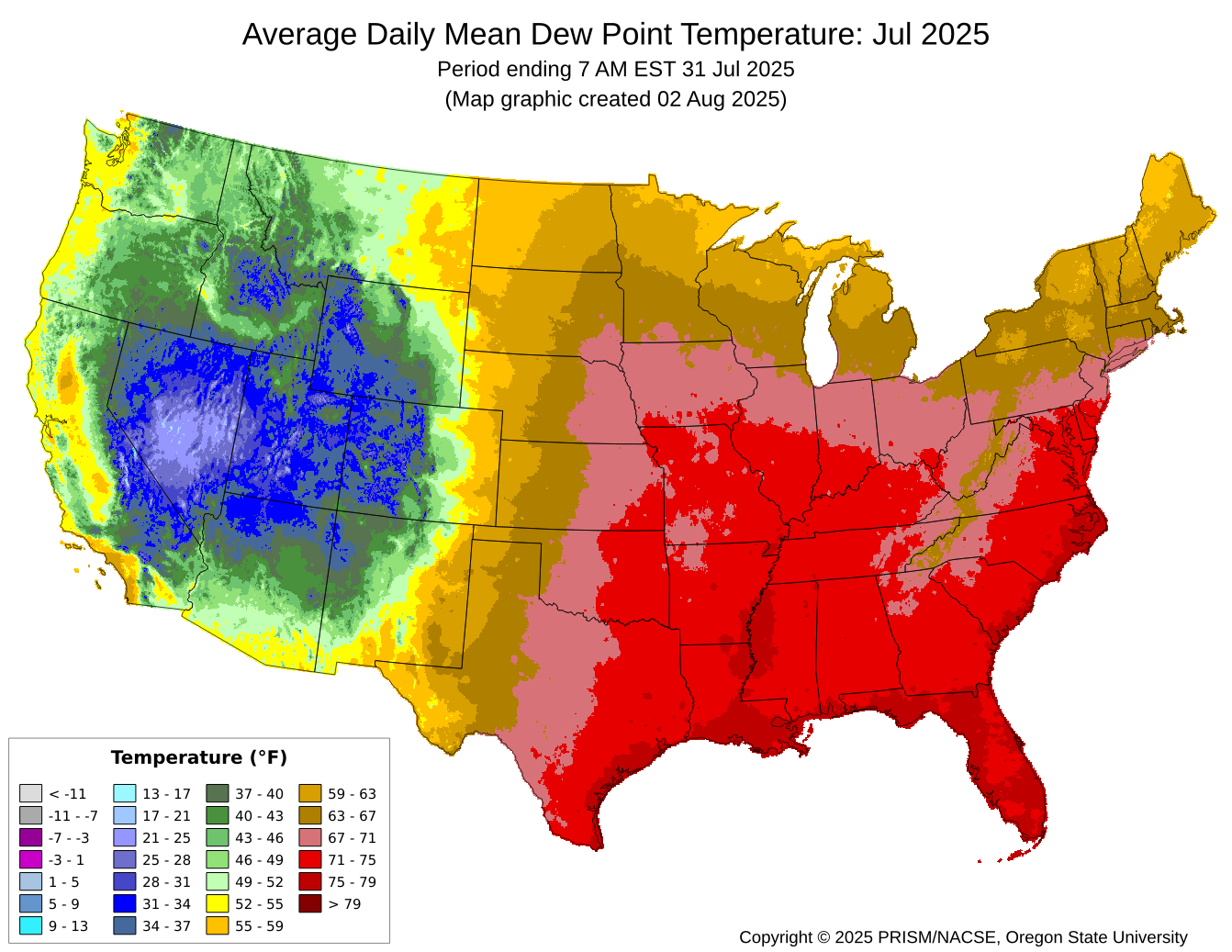
Figure 2. Average dew points in July 2025 from PRISM
In-situ data from stations around the state confirm the PRISM analysis with dew point averages ranging from 70.0°F in Falls City to 51.9°F in Kimball (Table 1).
| Station | 2025 | Avg | Top |
| Omaha | 69.0°F | 64.8°F | 71.5°F (2011) |
| Lincoln | 67.7°F | 64.5°F | 70.8°F (2011) |
| Falls City | 70.0°F | 67.1°F | 74.8°F (2011) |
| Norfolk | 67.0°F | 62.4°F | 69.5°F (2011) |
| Grand Island | 66.8°F | 62.3°F | 68.9°F (2011) |
| Holdrege | 66.7°F | 62.4°F | 67.2°F (1998) |
| North Platte | 64.1°F | 59.8°F | 67.0°F (2011) |
| Broken Bow | 64.1°F | 61.7°F | 67.4°F (2011) |
| Valentine | 62.8°F | 57.3°F | 63.7°F (2001) |
| McCook | 63.1°F | 60.8°F | 66.3°F (2001) |
| Scottsbluff | 54.5°F | 54.2°F | 61.2°F (2018) |
| Kimball | 51.9°F | 50.8°F | 54.4°F (2023) |
Table 1. Average dew point for various stations across Nebraska in July 2025. Thanks to the Iowa Environmental Mesonet (IEM) for easy access to station data.
All stations were above average for dew point last month but only Grand Island, Holdrege, and Valentine had a top 5 average July dew point. The honor for the most sultry July goes to 2011 when average dew points over 70°F extended to Lincoln and upper 60's extended almost to North Platte. Years with the lowest average dew points in July tend to either be drought years (e.g., 2012) or years with abnormally northerly flow that brings in more pleasant air masses from Canada (e.g., 2004).
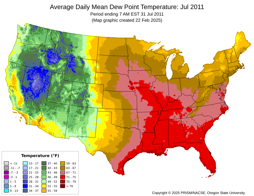
Figure 3. Average dew point in July 2011 according to PRISM
Reasons for humid summer
It was a wet spring across the southern U.S. (Figure 4), sea-surface temperatures in the Gulf and the Atlantic have been quite warm (Figure 5), there has been anomalous ridging at 500 mb over the eastern U.S. (Figure 6), and the Bermuda High has been expansive (Figure 7).
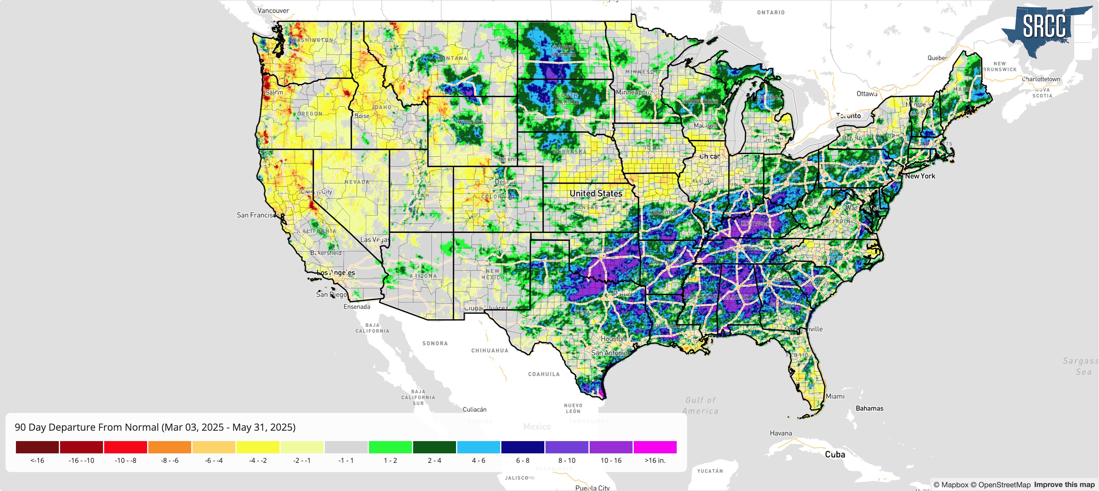
Figure 4. Spring 2025 precipitation anomalies
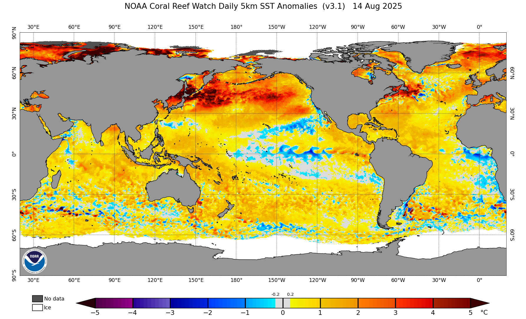
Figure 5. Sea surface temperature anomalies
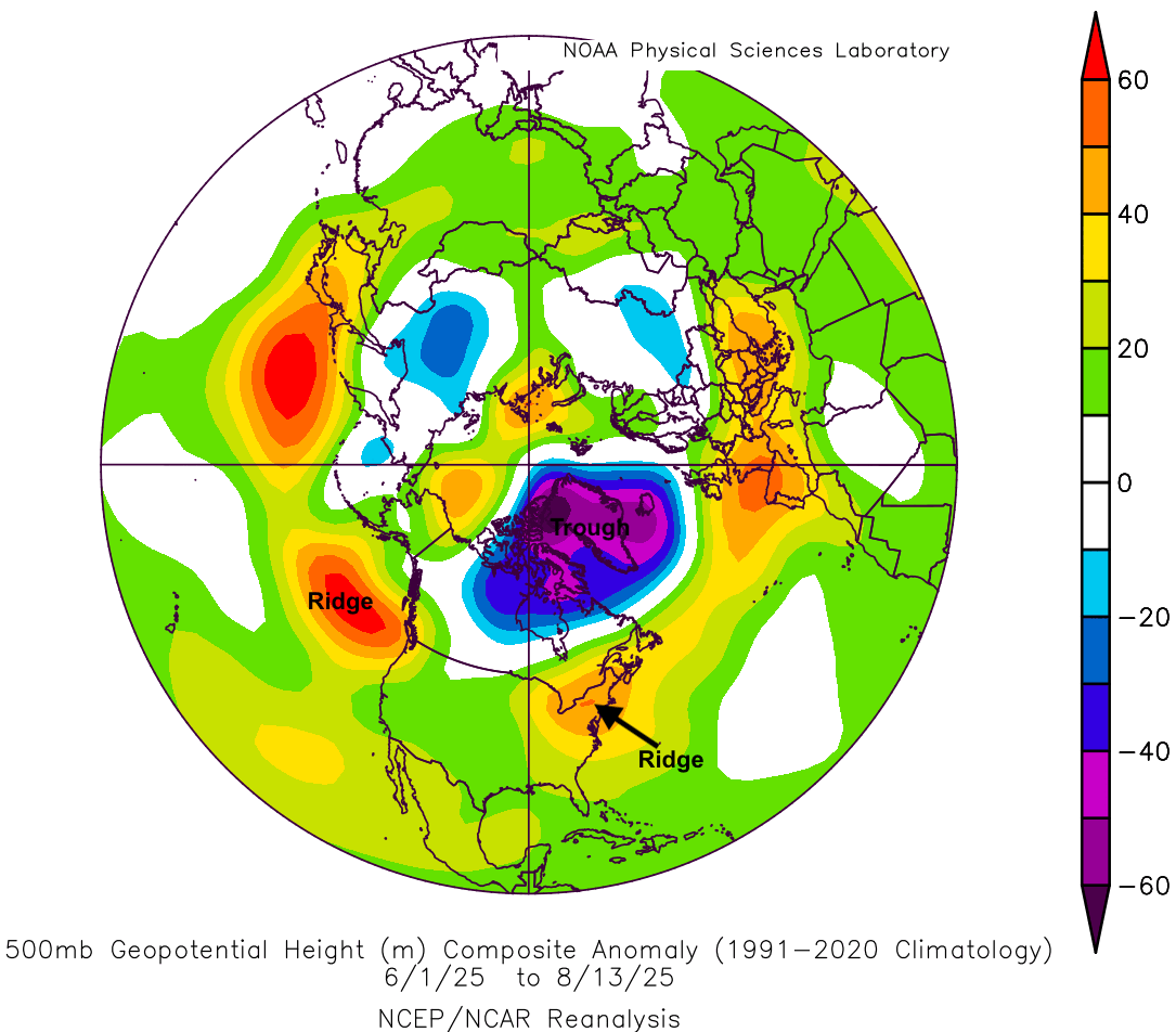
Figure 5. 500-mb height anomalies from June 1 to August 13th in the Northern Hemisphere
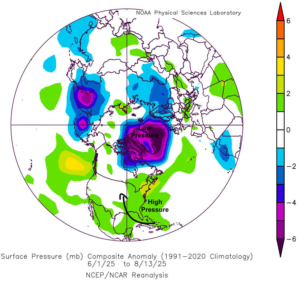
Figure 6. Surface pressure anomalies from June 1 to August 13th in the Northern Hemisphere
The wet spring across the southern U.S. meant that evapotranspiration (ET) in that region would not be impeded by water stress in the first part of summer, which in turn meant advection to the north from the Gulf would not be "robbed" by drier soils in the southern U.S. The expansiveness of the Bermuda High (Fig. 6) has meant more access to the Gulf and Atlantic than usual and the warm SST's ensure that it is very moist, humid air heading north. All of these factors have helped lead to a very wet summer in the Western Corn Belt. They also have led to abnormally high dew points for most of the eastern two-thirds of the U.S., including much of Nebraska.
The higher dew points combined with higher air temperatures has led to a large number of heat advisories and excessive heat warnings this summer east of the 100th meridian (which runs right through Cozad, NE). These warnings have been more common in recent years because of higher dew points and likely will become more frequent in future years as a warming planet means extra water vapor can be held. In other words, summers in much of Nebraska are going to be sultry more often than not in the coming years.