Hello NSCO Community, I hope all is going well. As we are halfway through February, I thought it would be important to discuss what we witnessed with the weather in January of 2026. So, below, I will discuss what was the general trend for the state in terms of temperatures, precipitation, weather events, and synoptic events for Nebraska.
January was a highly variable winter month across much of Nebraska, characterized by unseasonably warm periods early in the month, followed by multiple Arctic blasts, frequent strong wind events, and generally light but recurring snowfall, especially across northern and eastern Nebraska. While monthly precipitation totals were modest, the month featured several impactful cold snaps with dangerous wind chills, reinforcing the wintry character of late January. Large temperature swings and persistent northwest flow aloft also played a dominant role in shaping conditions statewide for most of the month.
Temperatures
Temperatures across Nebraska during January 2026 showed many spikes and dips, with sharp contrasts between early-month warmth and late-month cold.
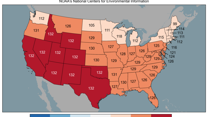
The first half of the month was marked by anomalous warmth, particularly from January 5–14. During this period, strong upper-level ridging and persistent warm air advection near 850 mb allowed afternoon highs to climb into the 50s and even into the 60s, especially across western and central Nebraska. These values were more typical of fall than of midwinter and contributed to heightened fire weather concerns on multiple days, driven by low relative humidity and gusty winds. Thank you to the Nebraska-Lincoln Climate Department Extension Educator, NSCO member, and employee, Eric Hunt, for providing the following figure to illustrate these unusually high temperatures.

The figure above shows specifically where we fell this January (us being the star). This shows the large, warm air prevailing over most of the state for the month, along with lower precipitation rates. Beginning around mid-month, the pattern transitioned as repeated Arctic air masses surged southward into the central United States. Temperatures moderated briefly at times but trended well below normal during the latter half of January, with a few mornings recording single-digit or sub-zero lows across most of Nebraska. The coldest conditions occurred late in January, when a strong surface high-pressure system combined with brisk northerly winds to produce wind chills ranging from −10°F to −35°F, particularly across northern and eastern Nebraska, specifically near Valentine, and Scottsbluff. Despite the late-month cold, brief warm-ups continued to occur, especially in western Nebraska, highlighting the persistent west-to-east temperature gradient across the state throughout the month.
Precipitation
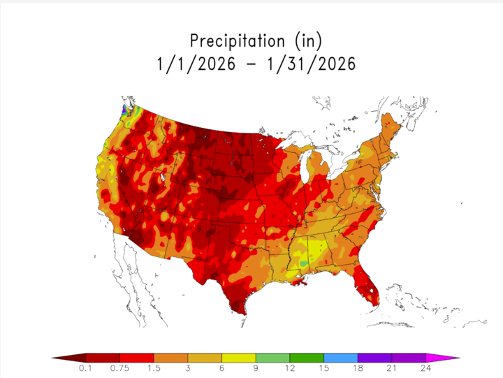
Overall, January 2026 was a relatively dry month, with most locations receiving below-normal precipitation, though a few light snowfall events contributed to minor accumulations.
The most notable precipitation occurred during those small systems rather than prolonged storms, as is normally seen in early to mid-spring. Early in the month, precipitation fell primarily as rain before transitioning to light snow in some areas, particularly in the southeastern and north-northeast sections of the state. As colder air became more established later in January, precipitation increasingly fell as snow, though accumulations generally remained light, often under an inch per event.
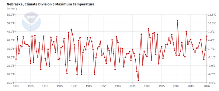
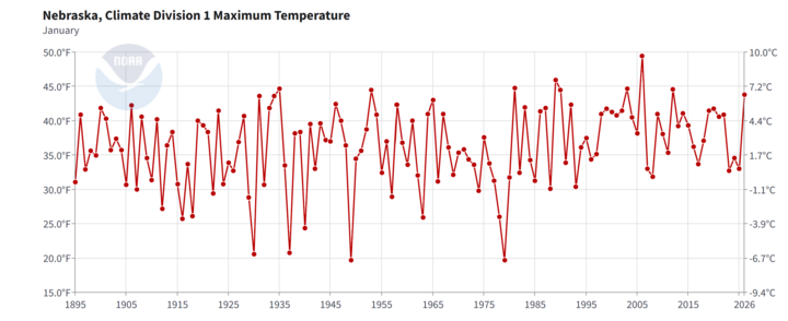
Northern and northeastern Nebraska experienced the highest snowfall totals, benefiting from weak frontogenesis bands and better moisture availability during several late-month systems. In contrast, central western portions of the state saw fewer snow impacts, with many events producing only flurries or trace amounts. The figure below represents specifically the very small amounts of precipitation experienced in the state for the month of January, including winter weather, and regular liquid precipitation.
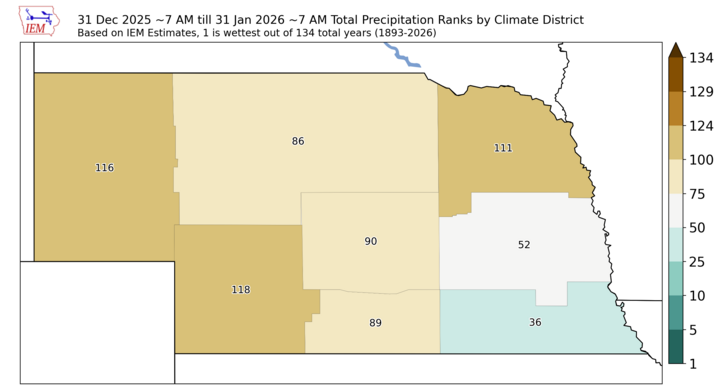
While no major winter storms occurred, the frequency of light snow events, combined with cold temperatures, contributed to periodic slick travel conditions, particularly on untreated roads, and along I-80. The figure below gives another correlation to those slightly higher precipitation values seen in the state, showing that east-central Nebraska, and southeast Nebraska got average to slightly above average for the majority of the month, while the other parts of the state experienced significantly less amounts.
Important Weather Events
Wind was a major contributor to weather impacts during January 2026. Several periods featured strong to damaging northwest winds, with gusts frequently exceeding 40 mph and occasionally reaching 50 mph or more.
These wind events played a dual role:
Early in the month, they heightened fire weather concerns amid warm, dry conditions across western Nebraska.
Later in the month, they exacerbated cold conditions, resulting in dangerously low wind chills across most of the state.
Multiple Cold Weather Advisories, Wind Advisories, and Extreme Cold Watches were issued during the second half of the month, reflecting the severity of the Arctic air masses affecting the region, and again impacting most parts of the state, especially north-central Nebraska.
To wrap things up, I wanted to reiterate important features for this past month's weather, precipitation, and temperature trends:
Conclusions
The highly variable temperatures created both near-record warmth and dangerous cold snaps across Nebraska.
We had below-normal precipitation, dominated by light snow events, which led to higher fire weather risks.
Frequent strong winds, which contributed to fire weather risk early, and extreme cold, which impacted later in the month, were the main issues for the state this past January.
Northern and eastern Nebraska experienced the most persistent winter impacts, which align with usual wintertime trends but leave the southern parts of the state with less-impacted areas regarding winter weather.