Record warm to cold in a few hundred miles
The orientation of how the ongoing polar vortex stretching is coupled in the troposphere is leading to a very sharp temperature gradient across the state. A look at upper air analysis shows broad ridging over the southwestern U.S., a deep trough over Quebec, and a strong NW-SE oriented jet stream from the Pacific Northwest into the southeastern U.S. In the lower part of the atmosphere, we have strong westerly, downslope flow that has led to very warm temperatures in eastern Wyoming and the Panhandle. That warm air will spread east into central sections of the state and will make an honest effort to get into southeastern Nebraska. Given the orientation of the NW-SE surface boundary this afternoon, temperatures will be much colder in northeast Nebraska. Southwestern Nebraska will be at or at least near record warm temperatures in the lower 70's this afternoon. Winds will be quite strong this afternoon in the Panhandle from the WNW.
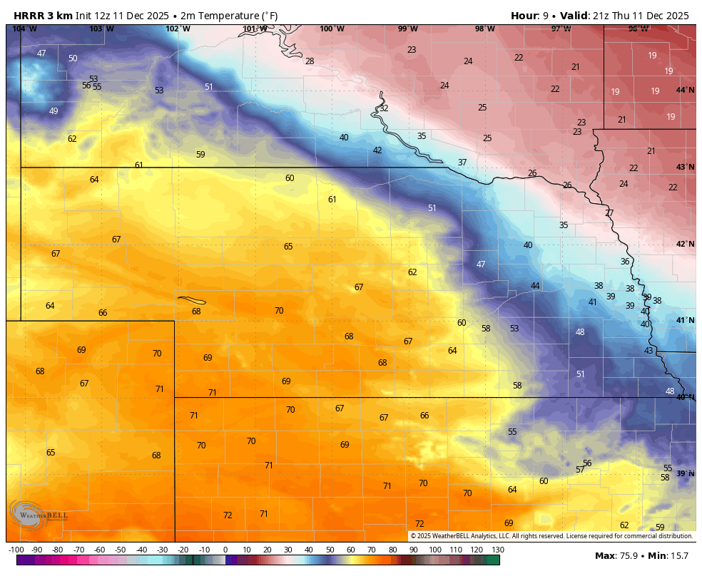
Figure 1. Afternoon high temperatures
Cold snap and snow chances
An arctic front will slide into the state overnight and winds will turn to the north. This will bring in colder temperatures for Friday, though the coldest temperatures will remain in northeast Nebraska. A strong arctic high pressure system will build into the Upper Midwest by Friday night and this will shift our winds to the northeast and east. There will be an area of surface convergence and rising motion along a NW-SE track from Montana into Iowa where light snow will be likely between later Friday into Saturday. Most of the state is likely to miss out on this but there will be a chance for an inch or two of snow between O'Neill over toward Wayne and Tekemah. This track may shift a bit north or south though, so pay attention to the forecast tomorrow night.
Saturday will be the coldest day in the state with highs in the single digits and teens in much eastern of north central Nebraska with 20's in south central Nebraska. Temperatures will be considerably warmer in far southwest Nebraska and the southern Panhandle where highs in the 40's will be likely. It is possible Bushnell could get into the lower 50's. Sunday morning will be cold to very cold for most of the state with subzero low temperatures likely for the northeast quadrant of the state.
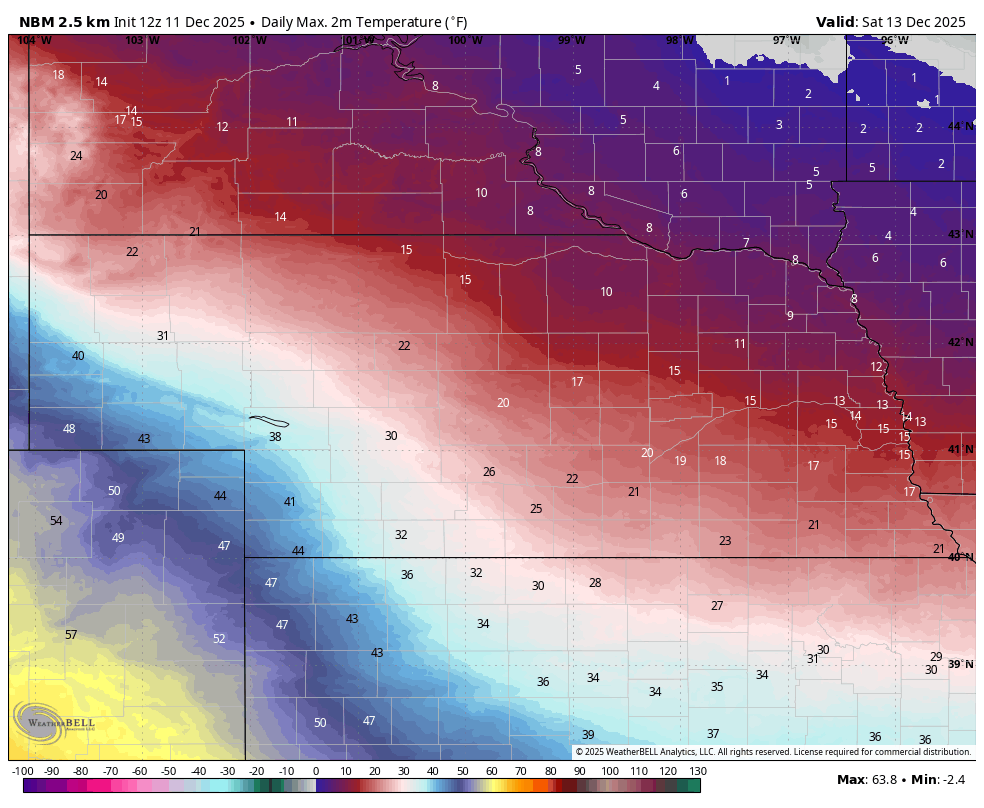
Figure 2. Forecast high temperatures on Saturday
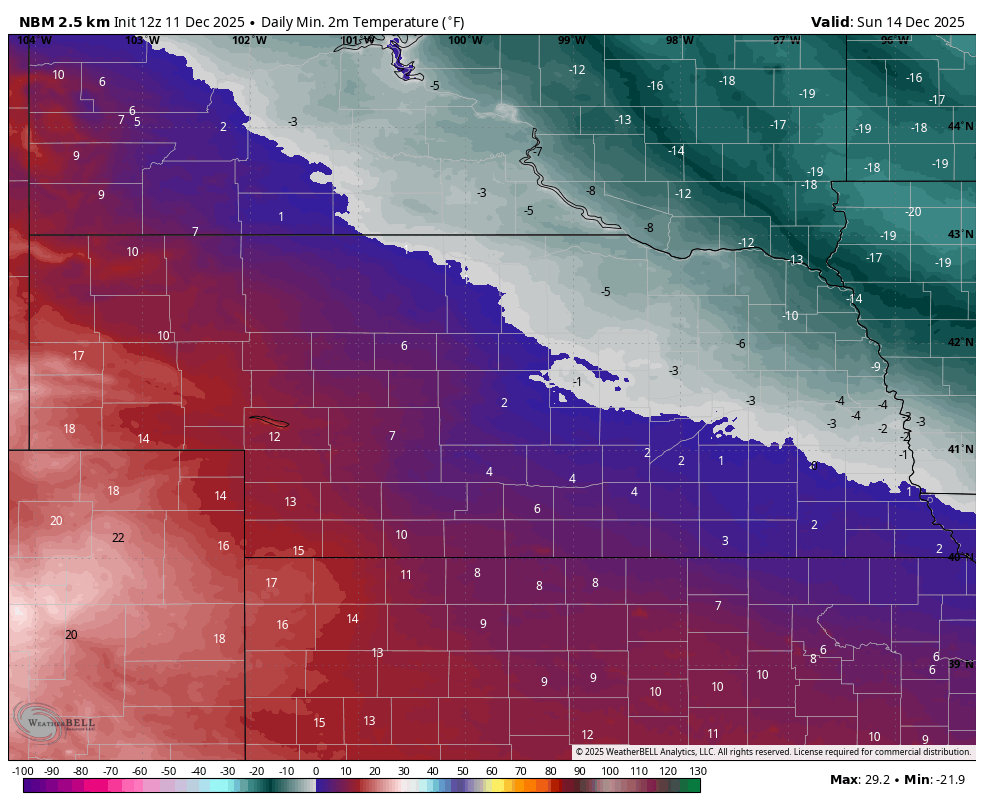
Figure 3. Forecast low temperatures on Sunday morning
The thaw
By Sunday afternoon the arctic high will be over western Illinois, which will put all of Nebraska back into southerly flow and moderating temperatures. The cold will still hang tough over eastern Nebraska where highs will remain in the upper teens to mid 20's, but still at least 5°F warmer than Saturday. The strong southerly winds will make for cold wind chills though. Temperatures will get progressively warmer heading west in the state with highs in the 30's across much of central Nebraska, 40's in west central Nebraska and highs getting into the 50's in the Panhandle. The warming trend continues early into the week with temperatures shooting up into the 40's and 50's in eastern sections of the state and remaining in the upper 50's to mid 60's elsewhere by Tuesday. No precipitation is expected during this period.
Brief return to cold temperatures
Mid-to-upper level ridging will be prominent across the central U.S. on Tuesday and Wednesday, which will help bring much more seasonal temperatures back to the broader region and significantly decrease the west-to-east temperature gradient that has been prominent of late. By Thursday morning another trough will enter the Great Lakes region and a cold front will move through the north central U.S. This will bring colder temperatures to the state temporarily, with coldest temperatures in the northeast part of the state. There will be a possibility of scattered showers in northern sections of the state with the frontal passage but the bulk of the moisture should remain to our north and east. Most places in the state are not likely to receive any significant precipitation next week and areas along and south of I-80 may not have any precipitation before Christmas.
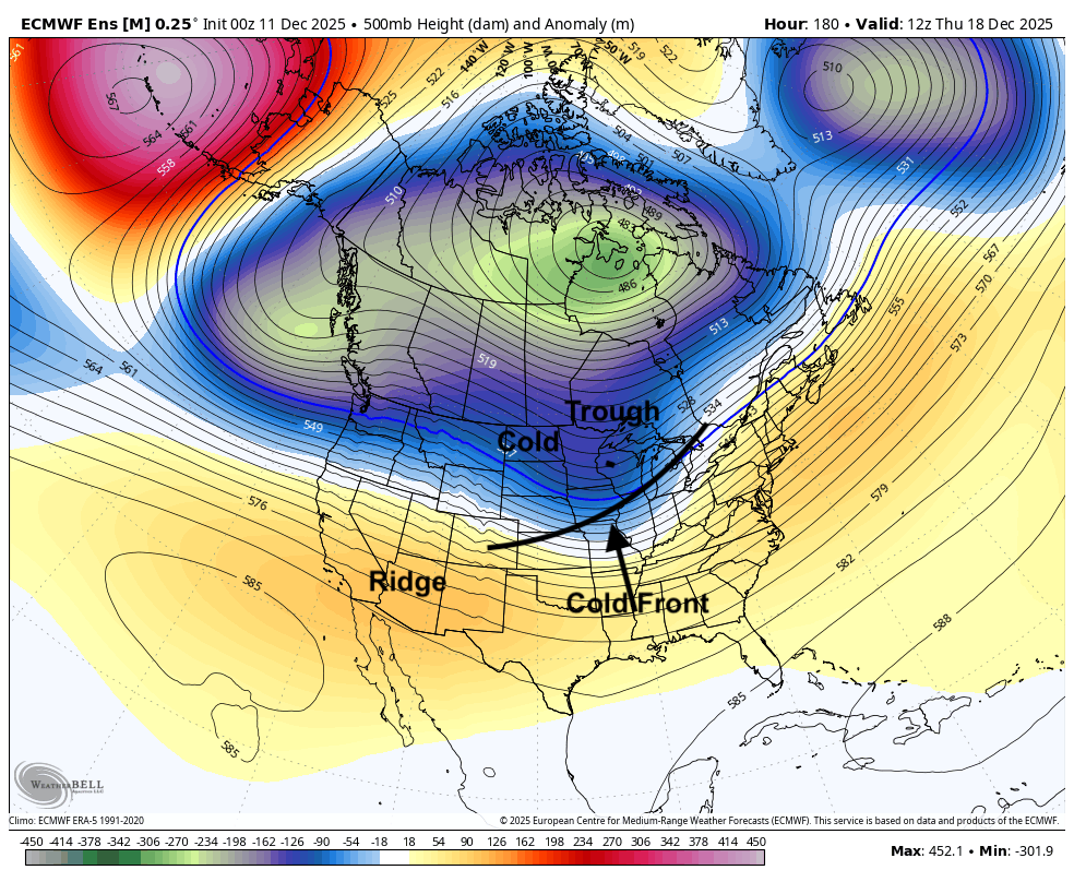
Figure 4. Projected 500-mb height anomalies next Thursday
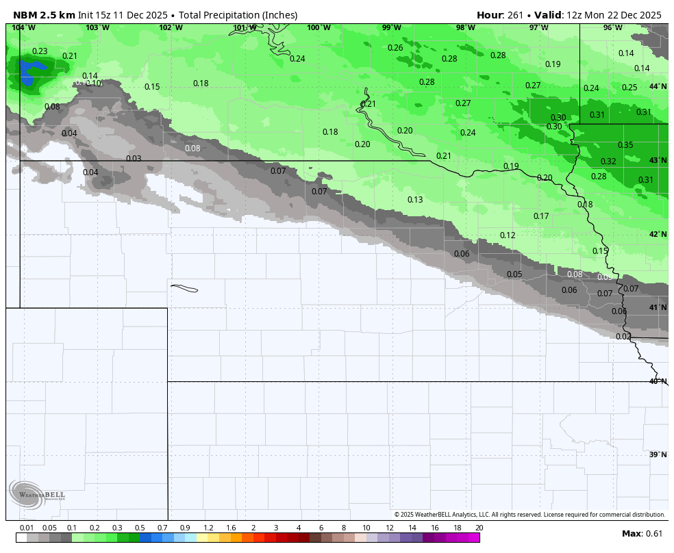
Figure 5. Projected precipitation totals through December 22nd from the National Blend of Models
Major pattern shift
The late week troughing over the Great Lakes region looks to be the end of the polar vortex stretching train and the beginning of a new pattern that will be drastically different than the one that we are in. This will feature broad ridging over the central U.S. with western troughing. This will lead to mild temperatures from the Rockies to the Great Lakes and very warm temperatures across the southern portion of the country in the period leading up to Christmas.
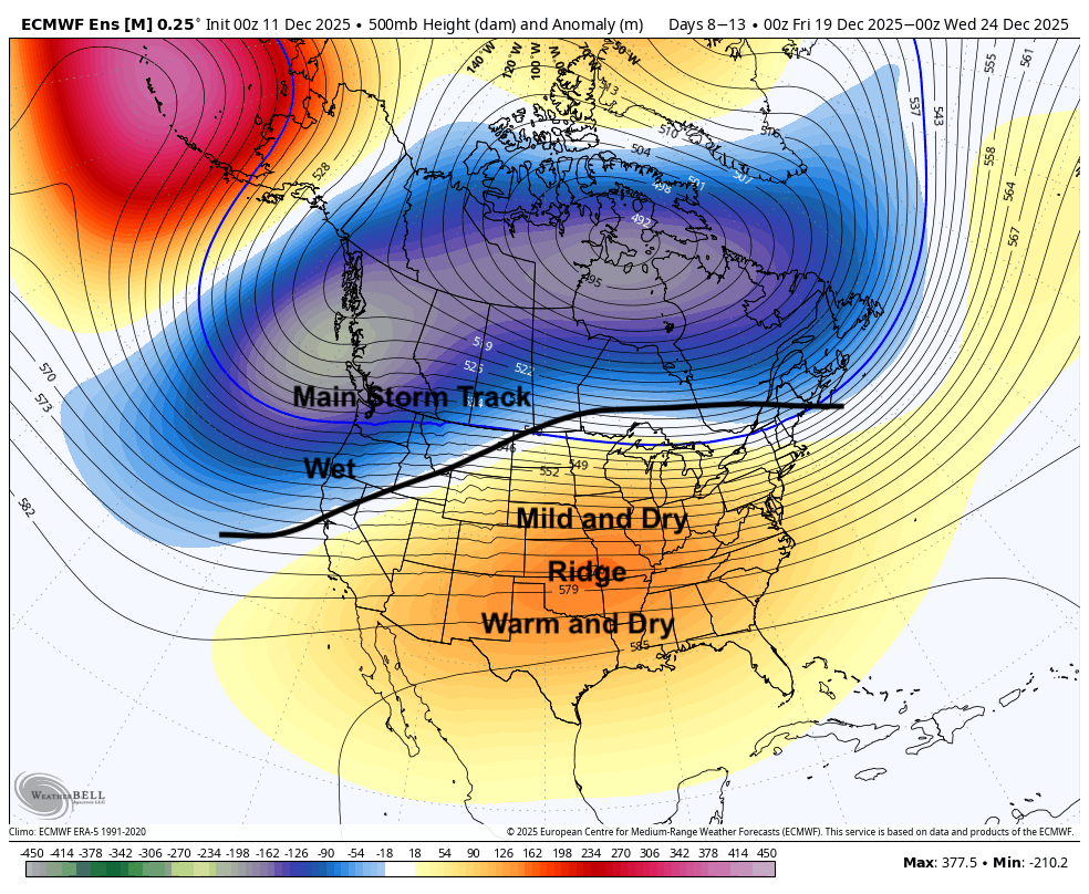
Figure 6. 500-mb height anomalies in the five days leading up to Christmas Eve.
With the main storm track well to our north and west, we should remain mostly dry during this period. It is possible a more active pattern would set up after Christmas if the troughing gets deeper into the west. Regardless, most indications are that our region would be warmer than average to finish out the month, so precipitation that does fall would most likely be in the form of rain. There is significant uncertainty as to what follows the early holiday season though. If the MJO swings around from phases 7 and 8 (Pacific) back into phases 1, 2, and 3 (Indian Ocean), that would likely lead to more deep troughing in the western U.S. with colder temperatures possibly coming back into the High Plains region. It also is possible this broader pattern is in place into January and winter takes an extended break.