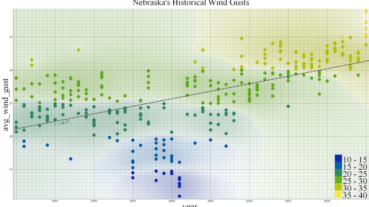
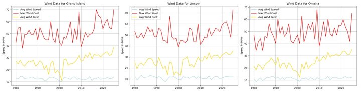
As time goes on, it has felt like the Midwest, and Nebraska particularly, is getting windier. Performing a climatology of our wind data going back forty five years shows that this is partially true. Compared to our neighboring states, Nebraska’s average wind speed has been 14% lower and our average wind gusts have been 20% weaker. Since 1985, the average wind speeds for Nebraska have steadily decreased; however, since 2000, we have recorded a significant increase in wind gusts. For the entire state, seven of the top ten recorded wind gusts occurred this year. On a location-by-location basis, six out of eight mesonet stations recorded their top ten years for wind gusts after 2000. Out of the eight stations, Grand Island, Lincoln, and Omaha showed the most drastic trends in terms of gusts. Though, their wind speeds only show a slight downward movement.
Decreased wind speed benefits us by reducing soil erosion that would otherwise threaten crop nutrients and riverbanks. Unfortunately, it also means a colder climate in general for spring time. This could delay plans for planting crops as the ground takes longer to thaw. This delayed thawing could also be exacerbated by high wind gusts. The gusts carry with them high wind chill and prevent further warming Increased wind gusts will also test standing vegetation, increasing the risk of tree fall in areas with shallower root systems such as suburban zones.
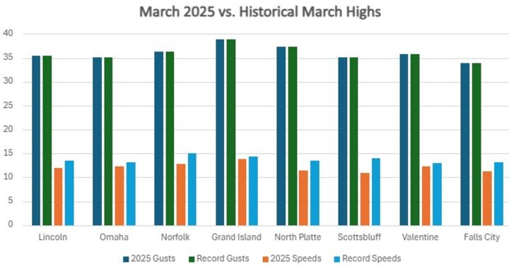
International research has previously highlighted the potential for a ‘global stilling’ by the year 2100 wherein wind speeds overall see a decrease by 10%. Our data shown here is consistent with global climate models. Current trends in Nebraska show a movement towards extremes. Average wind speeds decreasing and gust intensity increasing both reinforce global model predictions. It should be noted, however, that our analysis is isolated to the month of March and not for an entire year.